Florida Weather
Moderator: S2k Moderators
Forum rules
The posts in this forum are NOT official forecast and should not be used as such. They are just the opinion of the poster and may or may not be backed by sound meteorological data. They are NOT endorsed by any professional institution or STORM2K.
Re: Florida Weather
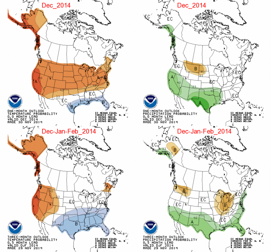
Big bust by the CPC which was calling for a cooler average month for FL, despite a very cool second week in December across the Peninsula the whole State ended up 1-3 deg F warmer than average for the month. The Caribbean Ridge was underestimated by the models.


0 likes
Re: Florida Weather
There was light convective rain activity on tuesday over the mainland. This is in the heart of dry season.
0 likes
- gatorcane
- S2K Supporter

- Posts: 23708
- Age: 48
- Joined: Sun Mar 13, 2005 3:54 pm
- Location: Boca Raton, FL
Its looking like Florida will cool down late next week. Details to be worked as we get closer to this event.
NWS Miami snippet:
AT THE SAME TIME...MODELS SURGE A 1050 MB SURFACE HIGH INTO THE
DAKOTAS BEFORE MODIFYING AND SETTLING OVER THE APPALACHIANS LATE
IN THE WEEK. THE ECMWF SHOVES THIS HIGH MUCH FURTHER TO THE SOUTH
WHICH TRANSLATES TO A MUCH COOLER SOLUTION FOR SOUTH FLORIDA
THURSDAY MORNING DEPICTING LOWS ACROSS PALM BEACH IN THE MID 50S
WHILE MEX GUIDANCE IS NEARLY 10 DEGREES WARMER. WEIGHTED MEX
NUMBERS MORE HEAVILY IN THIS FORECAST PACKAGE FOR NOW TO BETTER
BLEND WITH NEIGHBORING OFFICES. EITHER WAY...SLIGHTLY COOLER
TEMPERATURES SHOULD BE IN STORE FOR THE LATTER PART OF NEXT WEEK.

0 likes
-
TheStormExpert
- gatorcane
- S2K Supporter

- Posts: 23708
- Age: 48
- Joined: Sun Mar 13, 2005 3:54 pm
- Location: Boca Raton, FL
Ridge is starting to build in as the skies have becoming partly cloud across SE Florida with SE winds starting to pick up now across the terminals. Look for the winds to pick up even more later tonight and tomorrow for the weekend as the ridge builds. A very summer-like pattern in the upper atmosphere starting to setup though low-level temps remain pleasant with lows in the lower 70s and highs around 80F for the next several days. Can't ask for better weather for the first week in January.
0 likes
Re: Florida Weather
GFS for next week has upper 30s to lower 40s for lows for cfla, Euro has low to mid 30s, Euro ensemble slightly warmer than Euro, and finally GFS parallel warmer than the Euro and its ensemble and the GFS. Let's see how this will pan out. All the models show a general consensus of hostile teleconnections for Arctic air, so I am stunned by the GFS and (Euro's colder) persistent forecast for cold weather.
Additionally, there seems to be a SSW forming; will that save our winter? What do you all think will happen to our weather in the next month in addition to the SSW being a factor?
Additionally, there seems to be a SSW forming; will that save our winter? What do you all think will happen to our weather in the next month in addition to the SSW being a factor?
0 likes
This post is NOT AN OFFICIAL FORECAST and should not be used as such. It is just the opinion of the poster and may or may not be backed by sound meteorological data. It is NOT endorsed by any professional institution including storm2k.org. For Official Information please refer to the NHC and NWS products.
NWS has much cooler highs for us by late week...mid 60's around tampa bay to near 70 in ft myers. those early estimates are below normal by a few degrees but they get us there very slowly ( a few degree drop per day)...we all know it usually doesn't work this way so perhaps it's a low confidence forecast...temp forecasts frequently bust this time of year, especially in the extended but certainly worth keeping an eye on. with so much of the country cold you would have to think eventually we're gonna get chilly
0 likes
- northjaxpro
- S2K Supporter

- Posts: 8900
- Joined: Mon Sep 27, 2010 11:21 am
- Location: Jacksonville, FL
Yeah, the very latest model runs are seemingly coming into agreement and finally, it appears we will see a pattern change by Wednesday of next week. A trough looks to develop and amplify across the Eastern CONUS as some of that cold air across Canada will finally filter down toward the Deep South. At this time, the cold doesn't appear to be extreme, but looks to at least bring a return of minimum temps to near freezing across North Florida this time next week. As asd123 mentioned, the teleconnections still are considerably hostile as far as bringing in extreme or arctic cold in our region at this time. However, now that we may be seeing at least some shift in the pattern, still ample time for Mother Nature to deliver a big time cold air outbreak across the Eastern US from now until into the mid part of February in my view.
0 likes
NEVER, EVER SAY NEVER in the tropics and weather in general, and most importantly, with life itself!!
________________________________________________________________________________________
Fay 2008 Beryl 2012 Debby 2012 Colin 2016 Hermine 2016 Julia 2016 Matthew 2016 Irma 2017 Dorian 2019
________________________________________________________________________________________
Fay 2008 Beryl 2012 Debby 2012 Colin 2016 Hermine 2016 Julia 2016 Matthew 2016 Irma 2017 Dorian 2019
Re: Florida Weather
I wouldn't doubt the ECMWF's last couple of runs are correct about much "colder" weather coming for the FL Peninsula by the middle of next week in its very good medium range forecast but given the NAO going back to positive the cold of core Arctic air will stay to the north of us and exit quickly towards the Atlantic, the Euro shows the Caribbean Ridge claiming back its territory quickly afterwards. By the way, last night's Euro run has low temps in the low 30s all the way down to the suburbs of Tampa, mid to upper 30s for the Orlando area, widespread mid 20s for North FL. IMO, it might be a little too cold on its forecast, lets see if it keeps with this trend.
Until then temps back to the 80s for central FL this weekend
Until then temps back to the 80s for central FL this weekend
0 likes
-
SouthFloridian92
- Tropical Storm

- Posts: 120
- Age: 33
- Joined: Tue Dec 11, 2012 4:50 pm
- Location: Sebring, Florida
interestingly enough the 8-14 day outlook shows above normal temps and the 6-10 day shows normal... with highs in the upper 50's being way below normal this would seem to imply the cold shot is transient as we would need a return to above normal conditions before day 10 to average out to normal for the period.
0 likes
-
TheStormExpert
Re:
gatorcane wrote:Indeed models are latching onto this mid to end-of-week front for Florida next week...18Z GFS 2M Temps at their coldest. Looking nippy across Florida!
http://i59.tinypic.com/28w06ye.png
Both the 12z GFS & Euro have backed off a little.
0 likes
-
TheStormExpert
Re:
psyclone wrote:interestingly enough the 8-14 day outlook shows above normal temps and the 6-10 day shows normal... with highs in the upper 50's being way below normal this would seem to imply the cold shot is transient as we would need a return to above normal conditions before day 10 to average out to normal for the period.
Yeah this would be a very brief cool down if it happens, followed by a return to the stubborn SE Ridge pattern we've been in since just before Christmas.
0 likes
Re: Florida Weather
Well just as I thought it would do, the 12z Euro has backed away from freezing temps reaching I-4 from its run last night.
Is even a tad warmer for the peninsula from yesterday's 12z run.
But a cool down is still in the works.
Is even a tad warmer for the peninsula from yesterday's 12z run.
But a cool down is still in the works.
0 likes
- northjaxpro
- S2K Supporter

- Posts: 8900
- Joined: Mon Sep 27, 2010 11:21 am
- Location: Jacksonville, FL
Thanks NDG for the update on the trends with the very latest from the model runs. Yeah, the coopl down next week will be likely very brief, so at this point I will take any cool weather we can get, which has not happened the past couple oif weeks.
0 likes
NEVER, EVER SAY NEVER in the tropics and weather in general, and most importantly, with life itself!!
________________________________________________________________________________________
Fay 2008 Beryl 2012 Debby 2012 Colin 2016 Hermine 2016 Julia 2016 Matthew 2016 Irma 2017 Dorian 2019
________________________________________________________________________________________
Fay 2008 Beryl 2012 Debby 2012 Colin 2016 Hermine 2016 Julia 2016 Matthew 2016 Irma 2017 Dorian 2019
Re: Florida Weather
I haven't seen the 12z euro "back off" significantly. In fact, the long wave trough has consistently been shown to be rather deep all the way to the GOM from the last couple of days of ECM runs. From HPC:
...SENSIBLE WEATHER HIGHLIGHTS...
DAY 3/MONDAY BEGINS WITH A LARGE COLD ANTICYCLONE SPREADING ACROSS
THE EASTERN US WITH THE COLDEST CONDITIONS ACROSS THE NORTHERN
HALF OF THE STATES. ANOTHER EVEN COLDER ANTICYCLONE WILL BE POISED
OVER WESTERN CANADA TO DIVE SOUTHEASTWARD OVER THE NEXT SEVERAL
DAYS...BRINGING SOME OF THE COLDEST TEMPERATURES OF THE SEASON SO
FAR TO THE EAST.
BY DAY 4...LOW PRESSURE WILL DEVELOP OUT AHEAD OF THE SURGING COLD
AIR WITH SNOW DEVELOPING NORTH OF THE SYSTEM. ACCUMULATIONS LOOK
TO BE FAIRLY LIMITED ALTHOUGH SUCH SYSTEMS OFTEN HAVE A MESOSCALE
BAND/S OF HEAVIER SNOW BUT LOOKS TO AFFECT THE NORTHERN
PLAINS/MIDWEST AND PARTS OF THE NORTHEAST. A SURFACE HIGH WITH
PRESSURES PROBABLY EXCEEDING 1050 MB WILL MOVE TOWARD THE NORTHERN
PLAINS WITH COLD AIR SURGING ACROSS ALL OF THE EASTERN STATES INTO
THE GULF OF MEXICO. THIS PROCESS WILL OCCUR THROUGH DAYS 5 AND
6/WEDNESDAY INTO THURSDAY.
0 likes
Re: Florida Weather
Regarding the 12z Euro backing off, some of us were talking about it backing away from last night's run which showed low temps in the low 30s all the way down to Tampa. In today's 12z run it showed low temps higher in the upper 30s to low 40s along the I-4 corridor for next Friday morning.


0 likes
Return to “USA & Caribbean Weather”
Who is online
Users browsing this forum: Cpv17, Iceresistance and 117 guests


