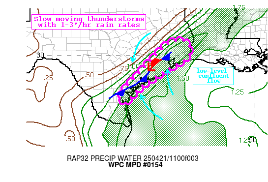
Mesoscale Precipitation Discussion 0154
NWS Weather Prediction Center College Park MD
1123 PM EDT Tue Apr 23 2019
Areas affected...North Texas
Concerning...Heavy rainfall...Flash flooding possible
Valid 240322Z - 240645Z
Summary...Several clusters of thunderstorms should move across
North Texas tonight. The tracks of these storms may overlap,
providing several rounds of heavy rainfall. This may lead to
localized flash flooding, with hourly rain rates in the strongest
storms approaching 2 inches.
Discussion...At 03Z, regional radars showed two convective
clusters with a similar overall mesoscale structure.
Forward-propagating clusters (compact bow echoes) were located
over Comanche and Tarrant Counties. Each cluster had a distinct,
broad and strong mesovortex on the northern half of the cluster,
and a wing of convection extended east from each. And finally,
trailing convection was noted on the upshear flank of both
clusters, likely forming on the periphery of some weak boundary
layer cold pools. The potential tracks of each cluster and its
associated convective elements do create some opportunities for
overlap. For example, the preceding wing of convection from the
Comanche County cluster was actually north of the trailing
convection associated with the Tarrant County cluster. And the
wing of convection on the northeast side of the DFW metro area has
already produced very heavy rain over southern Collin County, and
upstream convection may track over the same area. Therefore, some
locations could conceivably receive 1-2 hours of training
convection, which could lead to flash flooding, particularly if it
occurs over an urbanized area.
The environment will remain favorable for organized convection
over the next few hours. RAP analyzed MUCAPE exceeds 1000 j/kg and
the 00Z FWD sounding showed around 1700 j/kg of CAPE rooted near
the surface. When combined with precipitable water values around
1.5 inches (GPS-PW; 00Z FWD sounding), hourly rain rates
approaching 2 inches seems reasonable. One limiting factor will be
the forward propagating nature of the dominant convective
clusters. Forecast forward-propagating storm motions are nearly
west-to-east, while the deep layer mean wind is more southwesterly
(roughly parallel to the surface front and thetae gradient). The
result should be a tendency to move off the surface boundary,
which typically reduces the time frame for training. Nevertheless,
as described above, there should still be opportunities for
training in more focused areas, which could yield some localized
flash flooding. Upstream convection over the Concho Valley region
of Central Texas will be monitored for potential additional
rainfall layer in the night, beyond 06Z. This could maintain a
flash flood threat into the early morning hours in some parts of
North Texas.
Lamers
Winter time post are almost exclusively focused on the DFW area.


