Texas Spring 2025

U.S. & Caribbean Weather Discussions and Severe Weather Events

Moderator: S2k Moderators

Forum rules

The posts in this forum are NOT official forecast and should not be used as such. They are just the opinion of the poster and may or may not be backed by sound meteorological data. They are NOT endorsed by any professional institution or STORM2K.

Help Support Storm2K
Message
Author
User avatar
txtwister78
Category 5
Category 5
Posts: 1854
Joined: Wed Jan 30, 2019 12:56 pm
Location: San Antonio

Re: Texas Spring 2025

#981 Postby txtwister78 » Thu May 01, 2025 11:23 pm

Edwards Limestone wrote:
Edwards Limestone wrote:21z HRRR shows the later activity largely splitting SA and Austin with the large complex missing SA to the south from 1-3 am

Hopefully it's wrong, but it has been pretty spot on lately.


Split perfectly. HRRR nailed this. Nada for Austin south to New Braunfels.

Maybe the cold front will come through tomorrow but I won’t be betting on much in my backyard.

Glad the Hill Country got some isolated relief today at least.


I would say they did a little better than isolated relief tonight my friend. Widespread 1-2 inches of rain as far east as Sabinal with a few isolated 3 inch plus totals here and there so not bad at all considering certain models like the HRRR had little to nothing on previous runs out that way of which you actually cited earlier in a post as a reason to throw in the towel on today completely and focus on tomorrow's rain if I read that post correctly, so it's definitely had better days as a forecast tool than what we saw from it today that's for sure. Days like today can lead to surprises and yes disappointment I guess for some and so sometimes it's a little more complex than what any given model shows for a particular timeframe.

Jokingly, be sure to send any rain you don't want down my way tomorrow though. I'll gladly take it. :wink:

Seriously though, I'm willing to bet you do a little better than you think tomorrow. Good luck!
2 likes   

User avatar
wxman22
Category 5
Category 5
Posts: 1492
Joined: Mon Jan 30, 2006 12:39 am
Location: Wichita Falls, TX
Contact:

Re: Texas Spring 2025

#982 Postby wxman22 » Fri May 02, 2025 7:13 am

Enhanced risk issued today…

Image

Image

Image
0 likes   

User avatar
jasons2k
Storm2k Executive
Storm2k Executive
Posts: 8245
Age: 51
Joined: Wed Jul 06, 2005 12:32 pm
Location: The Woodlands, TX

Re: Texas Spring 2025

#983 Postby jasons2k » Fri May 02, 2025 8:47 am

From Jeff:

A higher end severe weather threat will evolve over the region today into this evening.

Have multiple ways to receive warnings!

An active day of weather is on tap for the region as a weak cold front move into an increasingly unstable air mass. Widespread thunderstorms will erupt as surface heating removes weak capping in place by late morning into the early afternoon hours with then large clusters or lines moving southward across the region into the late afternoon and evening hours. Activity should reach the coast and push offshore around midnight.

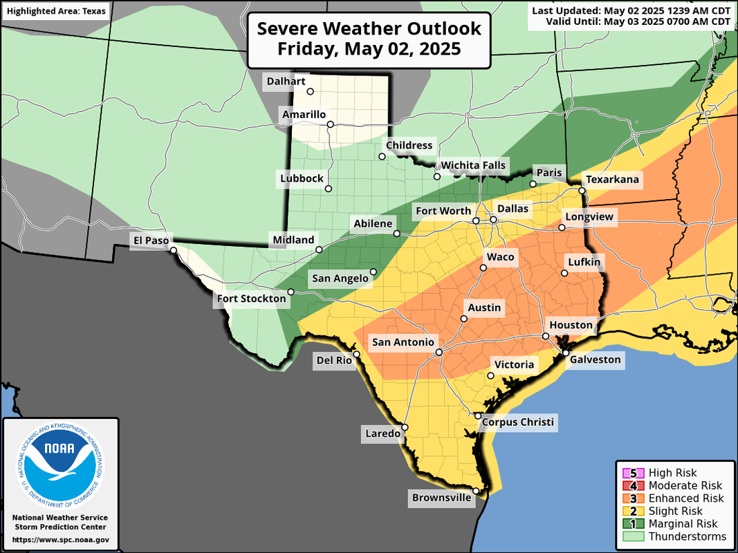
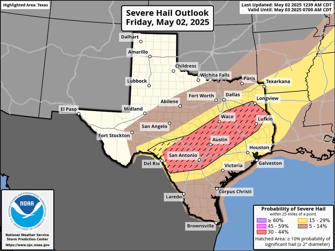
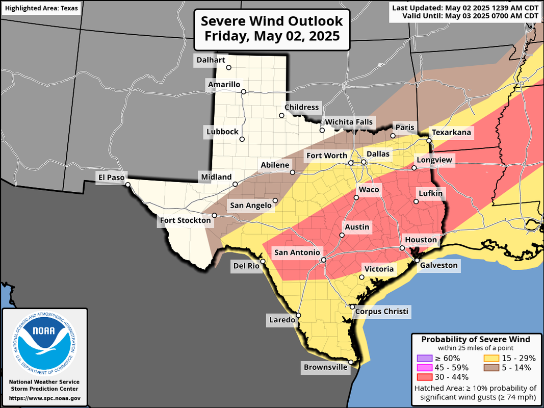
There is a pronounced severe weather threat this afternoon given high levels of instability in the atmosphere and increasing shear. All severe modes will be possible with damaging winds to 70mph and large hail up to 1-2 inches in diameter being the main threats. SPC has upgraded much of the region into an enhanced (level 3 out of 5) risk for severe weather. While the tornado threat is low, it is not zero and low level boundary mergers could result in local enhanced low level shear and a brief tornado. This is a day you want to be paying attention to the weather!

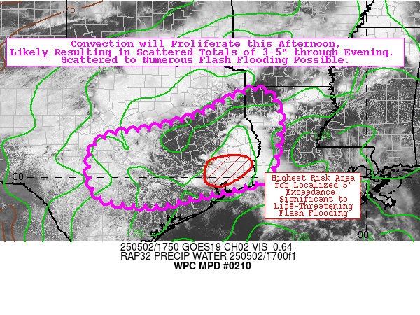
Given the slow moving nature of the frontal boundary along with the potential for storms and storm clusters to repeatedly move over the same areas the flash flood threat will be increased this afternoon and evening. Areas north of I-10 have now experienced at least two rounds of storms in the last 48 hours with grounds becoming increasingly saturated while much of the metro area and points south have seen little rainfall. Given the moisture in place, good low level feed off the western Gulf, and potential for training thunderstorms flash flooding and urban flooding could quickly develop. Widespread rainfall amounts of 1-3 inches will be likely with isolated higher totals upwards of 4-5 inches in a few hours.

Storm clusters or a large complex will make its way across the region early this evening and offshore by late evening with a drier air mass filtering in early Saturday and left over showers ending by sunrise.

Timing: Storms look to begin to develop as early as noon-100pm north of I-10 with more significant development and coverage in the 100-300pm timeframe with activity lasting well into the late evening hours especially for locations south of I-10.

Dry air and weak ridging will result in a fair and somewhat cooler weekend, but southerly flow quickly returns by late Sunday and Gulf moisture comes rushing back northward ahead of what looks to be a slow moving storm system for the mid to late part of next week. Overall pattern will support several rounds of severe thunderstorms and heavy/flooding rainfall across the state. This looks to be an increasingly classic May severe and flash flood scenario, but the fine details on timing, rainfall amounts, and the severe weather will have to be worked out in the coming days.

Jeff Lindner
Director Hydrologic Operations Division/Meteorologist
Harris County Flood Control District
9900 Northwest Freeway | Houston, Texas 77092
346-286-4000 (main) | 346-286-4165 (direct) | 281-924-2091 (cell)
Jeff.Lindner@hcfcd.hctx.net | Twitter: @jefflindner1
0 likes   

User avatar
Edwards Limestone
S2K Supporter
S2K Supporter
Posts: 476
Age: 36
Joined: Tue Dec 28, 2021 11:05 am
Location: Smithson Valley, TX

Re: Texas Spring 2025

#984 Postby Edwards Limestone » Fri May 02, 2025 10:59 am

txtwister78 wrote:
Edwards Limestone wrote:
Edwards Limestone wrote:21z HRRR shows the later activity largely splitting SA and Austin with the large complex missing SA to the south from 1-3 am

Hopefully it's wrong, but it has been pretty spot on lately.


Split perfectly. HRRR nailed this. Nada for Austin south to New Braunfels.

Maybe the cold front will come through tomorrow but I won’t be betting on much in my backyard.

Glad the Hill Country got some isolated relief today at least.


I would say they did a little better than isolated relief tonight my friend. Widespread 1-2 inches of rain as far east as Sabinal with a few isolated 3 inch plus totals here and there so not bad at all considering certain models like the HRRR had little to nothing on previous runs out that way of which you actually cited earlier in a post as a reason to throw in the towel on today completely and focus on tomorrow's rain if I read that post correctly, so it's definitely had better days as a forecast tool than what we saw from it today that's for sure. Days like today can lead to surprises and yes disappointment I guess for some and so sometimes it's a little more complex than what any given model shows for a particular timeframe.

Jokingly, be sure to send any rain you don't want down my way tomorrow though. I'll gladly take it. :wink:

Seriously though, I'm willing to bet you do a little better than you think tomorrow. Good luck!


I've def been a negative nancy lately. It's just been so hard to be positive after the last few years of bad luck down here. Hard to watch Canyon Lake make new all-time lows every day...

Hopefully this spring is the beginning of a long term pattern change for SCTX!
2 likes   
The above post is NOT an official forecast and should not be used as such. It is just the opinion of the poster and may or may not be backed by sound meteorological data. It is NOT endorsed by any professional institution including Storm2k. For official information, please refer to NWS products.

User avatar
jasons2k
Storm2k Executive
Storm2k Executive
Posts: 8245
Age: 51
Joined: Wed Jul 06, 2005 12:32 pm
Location: The Woodlands, TX

Re: Texas Spring 2025

#985 Postby jasons2k » Fri May 02, 2025 11:12 am

Mesoscale Discussion 0647
NWS Storm Prediction Center Norman OK
1105 AM CDT Fri May 02 2025

Areas affected...central into eastern Texas and far western Louisiana

Concerning...Severe potential...Severe Thunderstorm Watch likely

Valid 021605Z - 021800Z

Probability of Watch Issuance...95 percent

SUMMARY...The severe threat should increase into the afternoon hours as storms develop and become more widespread. The stronger storms may produce severe hail/wind gusts, and a couple of tornadoes cannot be ruled out. A Severe Thunderstorm Watch will eventually be needed over the next few hours.

DISCUSSION...A convective outflow boundary from earlier storms continues to slowly drift southward across central TX into LA, with clearing and insolation contributing to continued boundary-layer destabilization on both sides of the boundary. While strong storms may develop from re-intensifying convection across northern TX, the most likely location for the development of robust severe storms will be along the outflow boundary, as well as with convection that has already initiated in the warm sector across southeast TX. 7-8 C/km mid-level lapse rates are overspreading a moist boundary layer, characterized by 70+ F surface dewpoints, contributing to 3000+ J/kg MLCAPE. As the mid-level trough over the Plains states undergoes amplification this afternoon, and is overspread by 80+ kts of 300 mb westerly flow from an approaching sub-tropical jet stream, deep-layer shear should increase, supporting well over 40 kts of effective bulk shear. When considering the strong instability in place, several supercells should develop, accompanied by a severe wind and hail threat. Multiple instances of 2+ inch diameter hail are possible given the expected increase of strong mid to upper-level shear, and a couple of tornadoes cannot be ruled out, especially with any dominant supercell structures interacting with mesoscale boundaries. A Severe Thunderstorm Watch will be needed in the next few hours to address the impending severe threat.

..Squitieri/Hart.. 05/02/2025

...Please see www.spc.noaa.gov for graphic product...

ATTN...WFO...LCH...SHV...HGX...FWD...CRP...EWX...SJT...

MOST PROBABLE PEAK TORNADO INTENSITY...85-115 MPH
MOST PROBABLE PEAK WIND GUST...65-80 MPH
MOST PROBABLE PEAK HAIL SIZE...2.00-3.50 IN
0 likes   

TomballEd
Category 2
Category 2
Posts: 695
Age: 61
Joined: Wed Aug 16, 2023 4:52 pm
Location: Spring/Klein area, not Tomball

Re: Texas Spring 2025

#986 Postby TomballEd » Fri May 02, 2025 11:25 am

Image Graphic is good until about this time next year. All the image/gif sites blocked at work.

Image
1 likes   

rwfromkansas
Category 5
Category 5
Posts: 2627
Joined: Sat Aug 27, 2005 12:47 am
Location: North Fort Worth

Re: Texas Spring 2025

#987 Postby rwfromkansas » Fri May 02, 2025 11:58 am

Another .60 IMBY very quickly.
0 likes   

TomballEd
Category 2
Category 2
Posts: 695
Age: 61
Joined: Wed Aug 16, 2023 4:52 pm
Location: Spring/Klein area, not Tomball

Re: Texas Spring 2025

#988 Postby TomballEd » Fri May 02, 2025 12:04 pm

15Z HRRR shows widespread inch and a half rain totals through tonight in Houston, with a couple of small bombs over six inches. We need the rain. As long as I get home before it starts
0 likes   

Gotwood
Category 2
Category 2
Posts: 627
Joined: Wed Dec 14, 2022 7:18 pm
Location: Brock Tx

Re: Texas Spring 2025

#989 Postby Gotwood » Fri May 02, 2025 12:37 pm

Love the much needed rain. HRRR failed again.
0 likes   

TomballEd
Category 2
Category 2
Posts: 695
Age: 61
Joined: Wed Aug 16, 2023 4:52 pm
Location: Spring/Klein area, not Tomball

Re: Texas Spring 2025

#990 Postby TomballEd » Fri May 02, 2025 12:39 pm

Very brief but very heavy showers FM 2920/Imperial Valley/Hardy Tollroad area. Severe warning for confirmed hail not far NE of here.
0 likes   

TomballEd
Category 2
Category 2
Posts: 695
Age: 61
Joined: Wed Aug 16, 2023 4:52 pm
Location: Spring/Klein area, not Tomball

Re: Texas Spring 2025

#991 Postby TomballEd » Fri May 02, 2025 12:41 pm

0 likes   

User avatar
txtwister78
Category 5
Category 5
Posts: 1854
Joined: Wed Jan 30, 2019 12:56 pm
Location: San Antonio

Re: Texas Spring 2025

#992 Postby txtwister78 » Fri May 02, 2025 1:26 pm

Instability a little less today than yesterday with the cloud cover managing to hang around longer but nonetheless still supportive for severe storms. Tons of moisture to work with and so look for some messy storm clusters with some potential cell mergers putting down some heavy rain in spots. Right now, models in general seem to be converging on SC TX from north of US highway 90 to along and just north of the I-10 corridor from west to east as the favored area for heavier rainfall.

Perhaps with the cloud cover/lower instability today we can minimize some of that large hail risk, but lapse rates definitely support the enhanced risk especially across the areas that manage to break out of the cloud cover and maximize daytime heating later this afternoon.

Hopefully everyone gets some good rain today but keep an eye out for the hail threat and potentially an isolated Tornado risk along any outflow boundary.
Last edited by txtwister78 on Fri May 02, 2025 1:27 pm, edited 1 time in total.
1 likes   

rwfromkansas
Category 5
Category 5
Posts: 2627
Joined: Sat Aug 27, 2005 12:47 am
Location: North Fort Worth

Re: Texas Spring 2025

#993 Postby rwfromkansas » Fri May 02, 2025 1:27 pm

A FB friend has a farm in OK right on the Red River. It’s out of the banks flooding their pecan orchard. Second time in 10 years.
0 likes   

User avatar
txtwister78
Category 5
Category 5
Posts: 1854
Joined: Wed Jan 30, 2019 12:56 pm
Location: San Antonio

Re: Texas Spring 2025

#994 Postby txtwister78 » Fri May 02, 2025 1:28 pm

WPC already highlighting the region for potential flash flooding.

Image
1 likes   

User avatar
txtwister78
Category 5
Category 5
Posts: 1854
Joined: Wed Jan 30, 2019 12:56 pm
Location: San Antonio

Re: Texas Spring 2025

#995 Postby txtwister78 » Fri May 02, 2025 1:31 pm

Another watch likely per SPC for portions of the Hill Country and southern Edwards Plateau region.

Image
1 likes   

Bhow
Tropical Depression
Tropical Depression
Posts: 61
Joined: Wed Jul 06, 2016 11:52 am

Re: Texas Spring 2025

#996 Postby Bhow » Fri May 02, 2025 1:57 pm

txtwister78 wrote:Instability a little less today than yesterday with the cloud cover managing to hang around longer but nonetheless still supportive for severe storms. Tons of moisture to work with and so look for some messy storm clusters with some potential cell mergers putting down some heavy rain in spots. Right now, models in general seem to be converging on SC TX from north of US highway 90 to along and just north of the I-10 corridor from west to east as the favored area for heavier rainfall.

Perhaps with the cloud cover/lower instability today we can minimize some of that large hail risk, but lapse rates definitely support the enhanced risk especially across the areas that manage to break out of the cloud cover and maximize daytime heating later this afternoon.

Hopefully everyone gets some good rain today but keep an eye out for the hail threat and potentially an isolated Tornado risk along any outflow boundary.

After being stuck under clouds until around noon temps have skyrocketed south of Austin with almost completely clear skies. Currently sitting at 88 with dewpoint of 76
0 likes   

rwfromkansas
Category 5
Category 5
Posts: 2627
Joined: Sat Aug 27, 2005 12:47 am
Location: North Fort Worth

Re: Texas Spring 2025

#997 Postby rwfromkansas » Fri May 02, 2025 1:58 pm

Almost up to an inch of rain in north FW/Saginaw area.

Up to almost 6.50 over the past 7 days.

After getting missed so much this spring, nice to get ours.

I hope S TX can cash in.
1 likes   

mmmmsnouts
Tropical Storm
Tropical Storm
Posts: 152
Joined: Tue Sep 05, 2023 10:04 pm
Location: Arlington, TX

Re: Texas Spring 2025

#998 Postby mmmmsnouts » Fri May 02, 2025 2:07 pm

Another solid rain event in DFW. No flash flooding this time, which is even better. I just wish this pattern didn’t keep washing out every single outdoor activity my kids’ school tries to put together.
0 likes   

User avatar
txtwister78
Category 5
Category 5
Posts: 1854
Joined: Wed Jan 30, 2019 12:56 pm
Location: San Antonio

Re: Texas Spring 2025

#999 Postby txtwister78 » Fri May 02, 2025 2:37 pm

Bhow wrote:
txtwister78 wrote:Instability a little less today than yesterday with the cloud cover managing to hang around longer but nonetheless still supportive for severe storms. Tons of moisture to work with and so look for some messy storm clusters with some potential cell mergers putting down some heavy rain in spots. Right now, models in general seem to be converging on SC TX from north of US highway 90 to along and just north of the I-10 corridor from west to east as the favored area for heavier rainfall.

Perhaps with the cloud cover/lower instability today we can minimize some of that large hail risk, but lapse rates definitely support the enhanced risk especially across the areas that manage to break out of the cloud cover and maximize daytime heating later this afternoon.

Hopefully everyone gets some good rain today but keep an eye out for the hail threat and potentially an isolated Tornado risk along any outflow boundary.

After being stuck under clouds until around noon temps have skyrocketed south of Austin with almost completely clear skies. Currently sitting at 88 with dewpoint of 76


Yeah went from 78 to 85 here so definitely seeing some breaks in the cloud cover now across the region. That will enhance hail threat for those areas.
0 likes   

TomballEd
Category 2
Category 2
Posts: 695
Age: 61
Joined: Wed Aug 16, 2023 4:52 pm
Location: Spring/Klein area, not Tomball

Re: Texas Spring 2025

#1000 Postby TomballEd » Fri May 02, 2025 3:04 pm

0 likes   


Return to “USA & Caribbean Weather”

Who is online

Users browsing this forum: utpmg and 31 guests