
Thought I'd start a thread. Heat warnings for the entire central part of the US, except for Texas which would be under head warnings all summer if they used the same standards.
597 ridge right over Kansas City which is quite something for that far north. Dew points near 80 over MN/IA/SD with RUC showing due points of 84 over central Minnesota.
Mid-July Heat Wave
Moderator: S2k Moderators
Forum rules

The posts in this forum are NOT official forecast and should not be used as such. They are just the opinion of the poster and may or may not be backed by sound meteorological data. They are NOT endorsed by any professional institution or STORM2K.
Mid-July Heat Wave
0 likes


North Texas is in a heat advisory.
Dallas and Waco are under heat advisories, Austin isn't. Dividing line seems to be Bruceville-Eddy TX.
The daytime temps are the same in both places but Dallas and Waco are only getting down to 81 at night where Austin is hitting 77.
http://www.cpc.ncep.noaa.gov/products/p ... hreats.gif
Dallas and Waco are under heat advisories, Austin isn't. Dividing line seems to be Bruceville-Eddy TX.
The daytime temps are the same in both places but Dallas and Waco are only getting down to 81 at night where Austin is hitting 77.
http://www.cpc.ncep.noaa.gov/products/p ... hreats.gif
0 likes

I think this could become a very deadly and historic heatwave since it's been a long time since I've seen such a widespread (and potentially very long lasting) area of insane heat and humidex values. One reading in the US already almost matched the current Canadian record at 126F (52C) for a humidex value. It was just 1C short of the all time Canadian humidex record of 53C in Manitoba July 2007. The forecasts for southern Ontario are for near 30ºC air temps. for 7 full days at least with around 40ºC humidex accompanying them  .
.
While worldwide 2010 was the king of heatwaves for sure, this one in North America I think maybe much worse then anything last year here which is amazing.
BTW, there should be more recognition on Wikipedia of heatwaves as only the worst are actually separate articles. I couldn't find anything on this one coming up right now and heat is the number 1 killer in all weather related deaths.
Last edited by Cyclenall on Fri Jul 22, 2011 12:14 am, edited 2 times in total.
0 likes
-
Rgv20

- S2K Supporter

- Posts: 2466
- Age: 39
- Joined: Wed Jan 05, 2011 5:42 pm
- Location: Edinburg/McAllen Tx
Northern Minnesota, Wisconsin, Michigan, and almost all of the Province of Ontario is going to be unseasonably HOT as much as 5 degrees Celsius according to the GFS. 
GFS anomalies for the upcoming week.
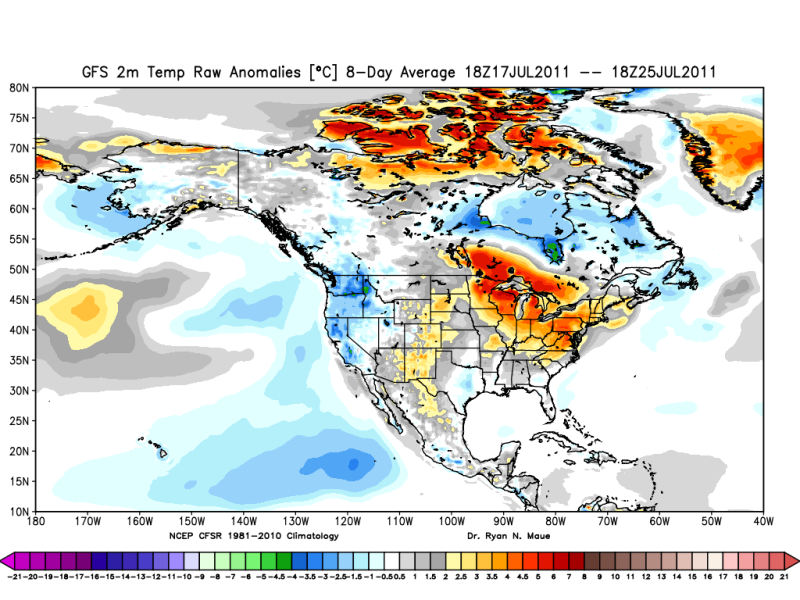
GFS anomalies for the upcoming week.
0 likes
The following post is NOT an official forecast and should not be used as such. It is just the opinion of the poster and may or may not be backed by sound meteorological data. It is NOT endorsed by any professional institution including storm2k.org For Official Information please refer to the NHC and NWS products.
-
somethingfunny

- ChatStaff

- Posts: 3926
- Age: 37
- Joined: Thu May 31, 2007 10:30 pm
- Location: McKinney, Texas
Re: Mid-July Heat Wave
^ GFS must be on crack if it's forecasting a below average temperature anomaly for Central Texas this upcoming week!
0 likes
I am not a meteorologist, and any posts made by me are not official forecasts or to be interpreted as being intelligent. These posts are just my opinions and are probably silly opinions.
Re: Mid-July Heat Wave
somethingfunny wrote:^ GFS must be on crack if it's forecasting a below average temperature anomaly for Central Texas this upcoming week!
I was wondering about that myself but saw Weather Underground forecast and it's 97 all week. It's below avg if avg is 100...
0 likes
-
SaskatchewanScreamer
-
SaskatchewanScreamer
-
Stephanie

- S2K Supporter
- Posts: 23843
- Age: 63
- Joined: Thu Feb 06, 2003 9:53 am
- Location: Glassboro, NJ
Re: Mid-July Heat Wave
We're supposed to get to 100 degrees on Friday/Saturday. They said 40 states are going to be under a "heat dome".
0 likes
Re: Mid-July Heat Wave
Lucky Lake, Saskatchewan recorded a dewpoint of 27C (80.6F) today... Yea, folks that's in Canada.
0 likes

-
angelwing

- S2K Supporter
- Posts: 4462
- Age: 64
- Joined: Tue Jan 18, 2005 3:06 pm
- Location: Kulpsville, PA
Re: Mid-July Heat Wave
Started up the van at 5AM and temp read 82, dew point was 70...up here we are not used to that yet
0 likes
Re: Mid-July Heat Wave
Maybe we should start comparing this heat wave to 1936...
-The state of Minnesota broke its all-time highest dew point when the city of Madison recorded a DP of 88F(31C). Previous record was 86F(30C)
-The state of Minnesota tied its highest heat index reading ever when Madison hit 124F(51C). BTW-Heat index is NOT humidex.
-The city of Minneapolis also broke its all-time DP when they hit 82F(28C). Previous record was 81F.
-Winnipeg tied its all-time highest humidex today while some cities in Manitoba/Saskatchewan had their highest humidex ever.
-I won't even talk about the records being broken in the south...
0 likes
-
Stephanie
- S2K Supporter
- Posts: 23843
- Age: 63
- Joined: Thu Feb 06, 2003 9:53 am
- Location: Glassboro, NJ
Re: Mid-July Heat Wave
Thank God we had some thundershowers this evening. Cooled things down and is helping to save everything from drying up in this heat.
0 likes
Re:
SaskatchewanScreamer wrote:Cyclenall the weather network just had 53C as Carman, Manitoba's record Canadian humidex high. I wonder which is accurate re 52 vs 53 C?
Feels like (dewpoint + temperature) here was 43°C (109.4°F) today.
Yeah I just heard that yesterday and thought about what I posted here as 52C was suppose to be 53C.
Nicko999 wrote:Lucky Lake, Saskatchewan recorded a dewpoint of 27C (80.6F) today... Yea, folks that's in Canada.
Never thought I'd ever see that
Nicko999 wrote:Maybe we should start comparing this heat wave to 1936...
-The state of Minnesota broke its all-time highest dew point when the city of Madison recorded a DP of 88F(31C). Previous record was 86F(30C)
-The state of Minnesota tied its highest heat index reading ever when Madison hit 124F(51C). BTW-Heat index is NOT humidex.
-The city of Minneapolis also broke its all-time DP when they hit 82F(28C). Previous record was 81F.
-Winnipeg tied its all-time highest humidex today while some cities in Manitoba/Saskatchewan had their highest humidex ever.
-I won't even talk about the records being broken in the south...
I was thinking of comparing the heatwave to 1988, 1980, and 1936 but more from an Ontario perspective. The July of 1988 was among the hottest I have ever read about in modern history for parts of southern Ontario with just endless streaks of 30ºC+ temperatures reaching near 38ºC some days. But to be honest I'm really not well versed with heatwave history so I have little to compare to.
About Heat index not being the same as Humidex, I had no idea that was the case!
Really this heatwave is very different from past heatwaves because I don't think I have ever felt so hot for such a extended period of time. Sleeping is hard currently and there are zero sheets with a fan on its highest setting. A news report on the heatwave four days ago said that overnight lows for the central plains in the US would exceed some normal daytime highs (coupled with extraordinary high dewpoints) and that would be devastating for those without air conditioning! Good choice of words
Here is the latest summary of the heatwave from the HPC:
HPC wrote:STORM SUMMARY NUMBER 05 FOR HIGH HEAT INDICES
NWS HYDROMETEOROLOGICAL PREDICTION CENTER CAMP SPRINGS MD
500 AM EDT TUE JUL 19 2011
...COMBINATION OF VERY HOT TEMPERATURES AND HIGH HUMIDITY WILL
CREATE DANGEROUS HEAT INDICES OVER THE CENTRAL U.S. THE HOT
WEATHER WILL SPREAD INTO THE EASTERN U.S. THIS WEEK...
EXCESSIVE HEAT WATCHES...WARNINGS AND HEAT ADVISORIES ARE IN
EFFECT FOR A LARGE PORTION OF THE CENTRAL U.S. AND OHIO RIVER
VALLEY. TEMPERATURES WILL FEEL LIKE 100 TO 110 DEGREES OR HIGHER
DURING THE AFTERNOON HOURS.
FOR A DETAILED GRAPHICAL DEPICTION OF THE LATEST
WATCHES...WARNINGS AND ADVISORIES...PLEASE SEE http://WWW.WEATHER.GOV
HEAT INDEX SAFETY INFORMATION AND MEANINGS OF WATCHES...WARNINGS
AND ADVISORIES CAN BE FOUND AT http://WWW.WEATHER.GOV/OM/HEAT/INDEX.SHTML
GRAPHICAL HEAT INDEX FORECASTS CAN BE FOUND AT
http://www.hpc.ncep.noaa.gov/heat_index_MAX.shtml
...SELECTED HIGH HEAT INDEX VALUES FROM MONDAY JUL 18 2011...
...ILLINOIS...
FREEPORT 124
MOLINE 112
RANTOUL 111
SAVANNAH 110
QUINCY 106
TAYLORVILLE 105
...INDIANA...
GRISSOM AFB 110
LAFAYETTE 106
INDIANAPOLIS 101
...IOWA...
KNOXVILLE 131
NEWTON 129
ATLANTIC 126
COUNCIL BLUFFS 126
ORANGE CITY 123
ALGONA 122
ANKENY 122
SPENCER 118
SIOUX CITY 117
WATERLOO 116
DES MOINES 114
...KANSAS...
LAWRENCE 110
TOPEKA 108
GREAT BEND 107
SALINA 107
WICHITA 107
HAYS 106
HILL CITY 106
...MICHIGAN...
LENAWEE COUNTY ARPT 107
ANN ARBOR 105
HILLSDALE 105
JACKSON 105
...MINNESOTA...
MADISON 124
HUTCHINSON 123
AUSTIN 121
REDWOOD FALLS 119
ROCHESTER 118
MARSHALL 117
MINNEAPOLIS 117
ST JAMES 117
NEW ULM 114
PIPESTONE 114
...MISSOURI...
KIRKSVILLE 107
WHITEMAN AFB 106
KANSAS CITY 105
...OKLAHOMA...
SHAWNEE 111
CHANDLER 109
ARDMORE 108
OKLAHOMA CITY 106
PONCA CITY 106
STILLWATER 106
...NEBRASKA...
OFFUTT AFB 117
TEKAMAH 117
HEBRON 115
FALLS CITY 113
LINCOLN 111
ALBION 110
KEARNEY 107
...SOUTH DAKOTA...
CHAMBERLAIN 115
MITCHELL 115
ABERDEEN 114
HURON 113
PIERRE 113
SIOUX FALLS 111
WATERTOWN 109
...TEXAS...
DALLAS 108
PARIS 106
TYLER 105
...WISCONSIN...
WATERTOWN 119
BOSCOBEL 117
LONE ROCK 115
MADISON 114
PRAIRIE DU CHIEN 114
VOLK 114
EAU CLAIRE 113
STEVENS POINT 110
MILWAUKEE 107
A LARGE RIDGE OF HIGH PRESSURE IN THE UPPER LEVELS OF THE
ATMOSPHERE REMAINS IN PLACE ACROSS THE CENTRAL U.S...KEEPING HOT
TEMPERATURES IN PLACE. THE HOT TEMPERATURES COMBINED WITH HIGH
RELATIVE HUMIDITY WILL CREATE DANGEROUS HEAT INDICES WELL ABOVE
100 DEGREES OVER A LARGE PORTION OF THE NATION. THE UPPER-LEVEL
RIDGE WILL EXPAND EASTWARD THIS WEEK. BY MIDWEEK...THE HOT
TEMPERATURES WILL BEGIN TO SPREAD INTO THE EASTERN STATES...WITH
HIGH TEMPERATURES IN THE MID TO UPPER 90S ARRIVING IN THE
MID-ATLANTIC STATES AS SOON AS WEDNESDAY. HIGH TEMPERATURES NEAR
100 DEGREES WILL BE POSSIBLE BY THURSDAY ACROSS MUCH OF THE
MID-ATLANTIC STATES AND PARTS OF THE SOUTHEAST U.S. THESE
TRIPLE-DIGIT TEMPERATURES ARE FORECAST TO REMAIN IN PLACE ACROSS
THE EASTERN U.S. THROUGH THE WEEKEND.
THE NEXT STORM SUMMARY WILL BE ISSUED BY THE HYDROMETEOROLOGICAL
PREDICTION CENTER AT 500 AM EDT...WEDNESDAY JULY 20. PLEASE REFER
TO YOUR LOCAL NATIONAL WEATHER SERVICE OFFICE FOR ADDITIONAL
INFORMATION ON THIS EVENT.
RYAN
Link: http://www.hpc.ncep.noaa.gov/discussions/nfdscc5.html
I can't even comprehend what 131F or 55C would feel like being outside. I have never seen such a value like that and I imagine it would be extremely dangerous to be outside for even a short time. The Canadian Humidex scale ranks anything above 54C as "Heat Stroke Imminent". Was outside work that was not necessary or emergency related canceled for the day there? I would treat that like a blizzard in terms of closures except cooling center operations. Just think, it would feel 4C cooler than what the all time worldwide record for hottest temperature ever recorded was
I don't have the number for the US highest Heat Index value record, does anyone know what it is and if 131F beat it or not?
7000th Post!!!
0 likes
-
angelwing
- S2K Supporter
- Posts: 4462
- Age: 64
- Joined: Tue Jan 18, 2005 3:06 pm
- Location: Kulpsville, PA
Re: Mid-July Heat Wave
Stephanie wrote:Thank God we had some thundershowers this evening. Cooled things down and is helping to save everything from drying up in this heat.
None in Philly last night at work and nothing at home in Lansdale...had a few measly drops on 476 on the way home last night but that was it, though it was not as humid as it was the night before!
0 likes
Re: Mid-July Heat Wave
July avg to date:
Topeka, Kansas: 87.9F (record warmest July is 90.5F in 1980)
Tulsa, Oklahoma: 90.0F (record warmest July is 91.7F in 1980)
Oklahoma City, Oklahoma: 89.2F (record warmest July is 88.3F in 1980 and 1934)
Huge heat wave for sure and we're not done yet...
Topeka, Kansas: 87.9F (record warmest July is 90.5F in 1980)
Tulsa, Oklahoma: 90.0F (record warmest July is 91.7F in 1980)
Oklahoma City, Oklahoma: 89.2F (record warmest July is 88.3F in 1980 and 1934)
Huge heat wave for sure and we're not done yet...
0 likes

Here in Tampa Bay, we do not see 130F heat index, but our AVERAGE July afternoon is in the 90's, dewpoints around 76F which means our average heat index is around 105-110F daily. This is unless a cooling storm comes by which this summer has provided precious little of. Even at 10am my local obs was 87F humidity 81% heat index 101F and it is only morning. BUt, we are used to it. Folks in the upper midwest are suffering for sure, and I hope it cools soon.
BTW PLEASE sends some rain to Tampa Bay, we are in desperate need of it! Driest summer I can remember in my 24 years here..
BTW PLEASE sends some rain to Tampa Bay, we are in desperate need of it! Driest summer I can remember in my 24 years here..
0 likes
Return to “USA & Caribbean Weather”
Who is online
Users browsing this forum: Cpv17, Stratton23, txtwister78 and 98 guests