The atmosphere had taken off, and the beginning of a record outbreak was on about now.
5 people died on this day in 2011 from tornadoes, and a few more from other severe weather. The worst tornado was in Vilonia, AR, with numerous other bad tornadoes.
Little did we know:
* The next 72 hours would see almost continuous tornadic activity - with only short breaks (something that was unprecedented)
* We were two days away from an absolute catastrophe
And this all as I was about to go on vacation, I missed out seeing on TV most of the extreme tornadoes, although I got a front row seat...
One year ago...
Moderator: S2k Moderators
Forum rules

The posts in this forum are NOT official forecast and should not be used as such. They are just the opinion of the poster and may or may not be backed by sound meteorological data. They are NOT endorsed by any professional institution or STORM2K.
-
CrazyC83
- Professional-Met

- Posts: 34315
- Joined: Tue Mar 07, 2006 11:57 pm
- Location: Deep South, for the first time!
One year ago...
0 likes
-
CrazyC83
- Professional-Met
- Posts: 34315
- Joined: Tue Mar 07, 2006 11:57 pm
- Location: Deep South, for the first time!
Here is how it flowed from what I could recall:
ROUND 1 - Initial supercells form in Texas, track into Arkansas that evening
ROUND 2 - Additional supercells from Round 1 quickly form into a QLCS which develops early in the morning of April 26 in Kentucky and southward before breaking later in the morning
Then, the only real break occurs - a brief one in the late morning and early afternoon of April 26, lasting about 5 hours
ROUND 3 - Redevelopment in Texas once again, tracking into Louisiana and southern Arkansas on the afternoon and evening of April 26
ROUND 3A - Concurrent isolated activity in the Great Lakes and Northeast on April 26
ROUND 4 - Late evening supercells on April 26 from Round 3 develop into an initial QLCS overnight into the morning of April 27
ROUND 5 - Another QLCS adds misery in Tennessee and Alabama late in the morning of April 27, setting up the outflow boundaries
ROUND 6 - CATASTROPHIC tornadoes develop in the heart of the outbreak, with extremely intense supercells virtually all producing violent tornadoes in Alabama and Mississippi on the afternoon of April 27
ROUND 6A - While the main event was happening, a secondary area of many tornadoes spread from Virginia and North Carolina all the way up to the eastern Great Lakes in Canada that afternoon and evening
ROUND 7 - The cold front itself takes over from 6 and 6A, with the supercells reforming into a QLCS/squall line near midnight into the morning of April 28, yet still producing tornadoes
ROUND 8 - The atmosphere tries to reload as the QLCS dissipates on the east coast on April 28, yet mercifully only manages to produce weak tornadoes as the supercells reach the Atlantic
0 likes
-
CrazyC83
- Professional-Met
- Posts: 34315
- Joined: Tue Mar 07, 2006 11:57 pm
- Location: Deep South, for the first time!
Re: One year ago...
0 likes
-
HurricaneBill
- Category 5

- Posts: 3419
- Joined: Sun Apr 11, 2004 5:51 pm
- Location: East Longmeadow, MA, USA
Re:
CrazyC83 wrote:I'm just wondering...did the 1974 Super Outbreak have significant tornado days leading into the big event on April 3, 1974? (In other words, were April 1 and 2 active?)
If I recall, yes they were.
April 1, 1974 had 19 tornadoes, including 3 F3s. One of the tornadoes produced a fatality.
April 2, 1974 produced 4 tornadoes, the strongest was an F2. Again, one of the tornadoes produced a fatality.
On both days, the tornadoes occurred in pretty much the same region that would be impacted by the Super Outbreak.
0 likes
-
CrazyC83
- Professional-Met
- Posts: 34315
- Joined: Tue Mar 07, 2006 11:57 pm
- Location: Deep South, for the first time!
Re: Re:
HurricaneBill wrote:CrazyC83 wrote:I'm just wondering...did the 1974 Super Outbreak have significant tornado days leading into the big event on April 3, 1974? (In other words, were April 1 and 2 active?)
If I recall, yes they were.
April 1, 1974 had 19 tornadoes, including 3 F3s. One of the tornadoes produced a fatality.
April 2, 1974 produced 4 tornadoes, the strongest was an F2. Again, one of the tornadoes produced a fatality.
On both days, the tornadoes occurred in pretty much the same region that would be impacted by the Super Outbreak.
Interesting, so there does seem to be a strong parallel. Of course, there probably were more unsurveyed tornadoes back in the day. Big similarity!
There is only one difference I can think of: the lack of Midwest activity in the 2011 outbreak (there were only a handful of twisters in IL/IN/OH/MI), while the Northeast/Mid-Atlantic (NY/PA/MD) didn't have that much in the 1974 outbreak.
0 likes
-
Dave

- Retired Staff

- Posts: 13442
- Age: 75
- Joined: Tue Aug 01, 2006 3:57 pm
- Location: Milan Indiana
- Contact:
There's a good article here about the April 3 - 4 outbreak that hit this area.
http://www.popularmechanics.com/science/environment/natural-disasters/4219870
Even using primitive 1950s-era radars, National Weather Service forecasters could tell something bad was brewing over the central United States. On April 2, 1974, a sprawling mass of cold, dry air dropped down from Canada towards the Mississippi and Ohio River valleys, and an opposite mass of warm, moist air pushed northwards from the Gulf of Mexico. They were set to converge beneath an intense jet stream with 140-mph winds at an altitude of 40,000 ft.
The forecasters knew these conditions made for extreme storms, but they had no idea exactly how strong they would be, how widespread, or even precisely where they would erupt. They issued 28 severe weather watches and 150 tornado warnings around the central and eastern United States.
As the three patterns collided, the contrast between the cold and warm fronts caused the warming air to rush upwards. The winds spiraled counterclockwise, and the jet stream propelled everything forward. It was a textbook formula for tornado creation.
On April 3, all hell broke loose: The storm system spun 148 tornadoes across 13 states. The first twisters touched down at 2 pm in Bradley County in south central Tennessee and Gilmer County in northwestern Georgia. Ten minutes later and 450 miles away, tornadoes were loosed across Central Illinois -- and across Indiana 10 minutes after that. Twisters raged as far south as Laurel, Miss., as far north as Detroit, and all the way east to Staunton, Va. A state trooper in Martinsburg, Ind., reported that the town just disappeared. After 15 hours, the tornadoes finally died down. They had traveled 2014 miles; the longest twister wreaked havoc for more than 100 miles.
See article for more...
Read more: Super Tornado Outbreak - 1974 - History - Interviews - Aftermath - Top Disasters - Popular Mechanics
0 likes
This post is NOT AN OFFICIAL FORECAST and should not be used as such. It is just the opinion of the poster and may or may not be backed by sound meteorological data. It is NOT endorsed by any professional institution including storm2k.org. For Official Information please refer to the NHC and NWS products.
-
CrazyC83
- Professional-Met
- Posts: 34315
- Joined: Tue Mar 07, 2006 11:57 pm
- Location: Deep South, for the first time!
Re: One year ago...
We were in a brief pause right now. About 70 tornadoes touched down on this day a year ago plus many more in the overnight leading into April 27. One person was killed in the evening and five people were killed overnight in Mississippi. The SPC outlook for April 26, 2011:

SPC AC 261234
DAY 1 CONVECTIVE OUTLOOK
NWS STORM PREDICTION CENTER NORMAN OK
0734 AM CDT TUE APR 26 2011
VALID 261300Z - 271200Z
...THERE IS A HIGH RISK OF SVR TSTMS LATE THIS AFTERNOON INTO
TONIGHT FOR NE TX...FAR SE OK...EXTREME NW LA...AND THE SRN HALF OF
AR...
...THERE IS A MDT RISK OF SVR TSTMS SURROUNDING THE HIGH RISK...FROM
NE TX/SE OK TO THE CONFLUENCE OF THE MS/OH RIVERS...
...THERE IS A SLGT RISK OF SVR TSTMS IN A BROAD SWATH FROM THE SRN
PLAINS EWD/NEWD TO THE MS/OH VALLEYS AND THE LOWER GREAT LAKES...
...DANGEROUS TORNADO AND SEVERE THUNDERSTORM OUTBREAK EXPECTED LATE
THIS AFTERNOON INTO TONIGHT FROM NE TX ENEWD TO THE MS RIVER...
...SYNOPSIS...
AN INITIAL SHORTWAVE TROUGH OVER MO/IL WILL EJECT NEWD TOWARD LOWER
MI TODAY...WHILE AN INTENSE UPSTREAM JET STREAK PROGRESSES ESEWD TO
THE SRN PLAINS BY TONIGHT. MORNING SUBSIDENCE OVER AR /IN THE WAKE
OF THE DEPARTING WAVE/ WILL BE REPLACED BY ASCENT BEGINNING ALONG
THE RED RIVER VALLEY OF N TX/SRN OK LATER THIS AFTERNOON...SPREADING
EWD THIS EVENING INTO SE OK/NE TX AND SRN AR OVERNIGHT. A STRONG
SURFACE CYCLONE WILL DEVELOP EWD ALONG THIS SAME CORRIDOR IN
RESPONSE TO STRONG UPPER DIVERGENCE IN THE LEFT EXIT REGION OF THE
90-100 KT MIDLEVEL JET. THE CYCLOGENESIS WILL ALSO PROMOTE THE
DEVELOPMENT OF A STRENGTHENING SLY/SSWLY LLJ FROM THE ARKLATEX TO
THE LOWER MS VALLEY OVERNIGHT. MEANWHILE...RICH BOUNDARY LAYER
MOISTURE ACROSS E TX...BENEATH A PLUME OF STEEP MIDLEVEL LAPSE RATES
ORIGINATING TO THE W...WILL PROVIDE MODERATE-STRONG WARM SECTOR
INSTABILITY IN ADVANCE OF THE DEVELOPING CYCLONE. THE NET RESULT
WILL BE A STRONGLY SHEARED AND UNSTABLE WARM SECTOR LATE THIS
AFTERNOON INTO TONIGHT...WHICH APPEARS SUPPORTIVE OF A DANGEROUS
TORNADO AND SEVERE THUNDERSTORM OUTBREAK.
...S/SE AR INTO NW MS TODAY...
INITIAL WARM ADVECTION STORMS WILL FORM DURING THE DAY ALONG AND N
OF THE OUTFLOW/WARM FRONT ACROSS S/SE AR AND NW MS...AS LOW-LEVEL
WAA INCREASES WITH A DEVELOPING LLJ. A FEW SUPERCELLS ARE EXPECTED
ALONG THE WARM FRONT...WHERE MODERATE INSTABILITY AND EFFECTIVE SRH
AOA 200 M2/S2 WILL BE SUPPORTIVE OF A FEW TORNADOES...IN ADDITION TO
LARGE HAIL AND DAMAGING WINDS.
...ARKLATEX/SE OK LATE THIS AFTERNOON INTO EARLY TONIGHT...
OVERNIGHT CONVECTION THAT MOVED OVER AR/NW MS LEFT AN E-W OUTFLOW
BOUNDARY THAT WILL BECOME THE EFFECTIVE WARM FRONT TODAY. FARTHER
S...A WEAKENING MCS OVER SRN LA/MS HAS GENERATED A COLD POOL ACROSS
CENTRAL LA/E TX...BUT AN UNIMPEDED FEED OF LOW 70S BOUNDARY LAYER
DEWPOINTS REMAINS TO THE W OF THIS CONVECTION ACROSS SE TX. THE SE
TX MOISTURE WILL SURGE NWD TODAY AS THE SRN LA STORMS
DISSIPATE...WHILE STEEP MIDLEVEL LAPSE RATES WILL CONTINUE TO
OVERSPREAD THE WARM SECTOR FROM THE W. THESE PROCESSES...COMBINED
WITH DAYTIME HEATING...WILL CONTRIBUTE TO AFTERNOON MLCAPE VALUES OF
2500-3500 J/KG IN THE NE TX WARM SECTOR...WITH SOMEWHAT LESSER
INSTABILITY FARTHER E ACROSS NRN LA/SRN AR...AND FARTHER N INTO SE
OK.
SUPERCELLS ARE EXPECTED TO INITIATE BY MID-LATE AFTERNOON ACROSS
N/NE TX...ALONG THE WARM FRONT AND DRYLINE TO THE IMMEDIATE E/SE OF
THE SURFACE LOW...AND SPREAD EWD TOWARD SW AR/NW LA THROUGH TONIGHT.
THE STRONG INSTABILITY...EFFECTIVE BULK SHEAR IN EXCESS OF 60
KT...EFFECTIVE SRH OF 300-500 M2/S2...AND A SUFFICIENTLY MOIST
BOUNDARY LAYER WILL BE FAVORABLE FOR LONG-TRACK/DAMAGING TORNADOES
WITH DISCRETE AND CLUSTER SUPERCELLS INTO THE LATE EVENING/EARLY
NIGHTTIME HOURS. VERY LARGE HAIL AND DAMAGING WINDS WILL ALSO BE
LIKELY WITH THE INITIAL SUPERCELLS.
...NRN LA/SE AR/NW MS/WRN TN TONIGHT...
AS THE STRONG SYNOPTIC CYCLONE PROGRESSES EWD AND INTERACTS WITH THE
UNSTABLE WARM SECTOR...INTENSE CONVECTION IS LIKELY THROUGH THE
OVERNIGHT HOURS. INITIAL TORNADIC SUPERCELLS IN NE TX/SW AR AREA
SHOULD EVENTUALLY GROW UPSCALE INTO ONE OR MORE INTENSE
MCS/S...WHICH COULD EVOLVE INTO BOW ECHOES WITH THE POTENTIAL FOR
WIDESPREAD/INTENSE DAMAGING WINDS...AS WELL AS TORNADOES. THIS
ACTIVITY SHOULD PROGRESS QUICKLY EWD/NEWD TO THE MS RIVER LATE
TONIGHT AS THE SYNOPTIC WAVE BEGINS TO EJECT ENEWD.
...OH VALLEY REGION THROUGH EARLY TONIGHT...
THE EJECTING LEAD SHORTWAVE TROUGH WILL PROVIDE A BROAD SWATH OF
MODERATE-STRONG SWLY MIDLEVEL FLOW...ABOVE RESIDUAL BOUNDARY LAYER
DEWPOINTS IN THE UPPER 50S TO LOWER 60S. THE LINGERING CLOUDS AND
RESIDUAL OUTFLOW FROM PRIOR CONVECTION MAKE THE CONVECTIVE EVOLUTION
SOMEWHAT UNCERTAIN TODAY ACROSS THE OH VALLEY REGION...THOUGH
SURFACE-BASED INSTABILITY WILL BE SUFFICIENT FOR A FEW SUPERCELLS
AND/OR BOWING SEGMENTS WITH A RISK FOR A COUPLE OF
TORNADOES...DAMAGING WINDS...AND ISOLATED LARGE HAIL.
..THOMPSON/COHEN.. 04/26/2011
CLICK TO GET WUUS01 PTSDY1 PRODUCT
NOTE: THE NEXT DAY 1 OUTLOOK IS SCHEDULED BY 1630Z
Last edited by CrazyC83 on Thu Apr 26, 2012 10:02 am, edited 2 times in total.
0 likes
-
CrazyC83
- Professional-Met
- Posts: 34315
- Joined: Tue Mar 07, 2006 11:57 pm
- Location: Deep South, for the first time!
Re: One year ago...
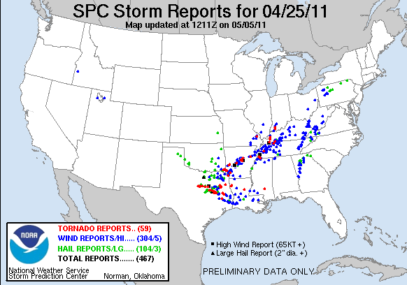
The end result for April 25, 2011 - a significant tornado outbreak day in its own right:
0 likes
-
Stephanie

- S2K Supporter

- Posts: 23843
- Age: 63
- Joined: Thu Feb 06, 2003 9:53 am
- Location: Glassboro, NJ
Re: One year ago...
April does seem to have some of the more extreme outbreaks, even though the most number of tornadoes are in May on average. The country is just waking up or close to waking up from winter and the warmth of spring is trying to make it's entrance. It kind of makes sense that there would be a several day outbreak as the opposing air masses fight their way across the country.
0 likes
-
CrazyC83
- Professional-Met
- Posts: 34315
- Joined: Tue Mar 07, 2006 11:57 pm
- Location: Deep South, for the first time!
At this point, the main event for April 26 had happened in Texas and Louisiana. It had started to form the squall line that was the first of three rounds of activity in the heart of Dixie Alley...the third one being the KO punch.
And for me? I was getting ready to go to bed, head out on vacation, not knowing what lied ahead...
And for me? I was getting ready to go to bed, head out on vacation, not knowing what lied ahead...
0 likes
-
CrazyC83
- Professional-Met
- Posts: 34315
- Joined: Tue Mar 07, 2006 11:57 pm
- Location: Deep South, for the first time!
Re: One year ago...
0 likes

It so it began...
Its midnight one year ago on the day that will remain legendary for weather freaks everywhere.
0 likes
-
CrazyC83
- Professional-Met
- Posts: 34315
- Joined: Tue Mar 07, 2006 11:57 pm
- Location: Deep South, for the first time!
Re: One year ago...
The INITIAL Day 1 forecast for April 27, 2011. Words simply cannot do justice. Although the area may have been too small, the greatest threat area was VERY well pinpointed.
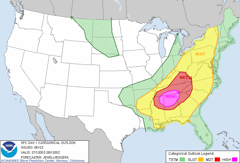
SPC AC 270610
DAY 1 CONVECTIVE OUTLOOK CORR 1
NWS STORM PREDICTION CENTER NORMAN OK
0110 AM CDT WED APR 27 2011
VALID 271200Z - 281200Z
...THERE IS A HIGH RISK OF SVR TSTMS OVER PORTIONS OF NRN
MS...AL...FAR NWRN GA AND SRN MIDDLE TN...
...THERE IS A MDT RISK OF SVR TSTMS OVER MUCH OF CNTRL AND NRN MS
AND AL...NWRN GA...MUCH OF TN AND KY...WRN CAROLINAS...
...THERE IS A SLGT RISK OF SVR TSTMS FROM THE LOWER MS VALLEY/GULF
COAST STATES NWD TO THE CANADIAN BORDER...
CORRECTED FOR SPELLING ERROR
...SYNOPSIS...
AN UPPER TROUGH AXIS WILL BE CENTERED ACROSS THE SRN PLAINS AT 12Z
WED...WITH A 100 KT MID LEVEL JET ACROSS N TX. THIS FEATURE WILL
STRENGTHEN THROUGH 00Z AS IT EJECTS NEWD ACROSS THE LOWER MS AND
INTO THE TN/OH VALLEYS DURING THE DAY. AT THE SURFACE...LOW PRESSURE
IS FORECAST TO BE OVER W CNTRL AR AT 12Z...WITH A DEVELOPING COLD
FRONT TRAILING SWWD INTO ERN TX. THESE FEATURES WILL MOVE RAPIDLY
ENEWD...WITH THE SURFACE LOW NEARING SRN INDIANA BY 00Z AND A SHARP
LOW PRESSURE TROUGH EXTENDING SWD INTO CNTRL KY...MIDDLE TN...ERN MS
AND WRN AL.
AHEAD OF THE FRONT...A VERY WARM AND MOIST AIR MASS WILL ALREADY BE
IN PLACE BY MIDDAY WITH 68-72 BOUNDARY LAYER DEWPOINTS LIKELY FROM
THE GULF COAST INTO MS/AL...AND MID TO UPPER 60S F OVER TN AND SRN
KY WHERE SUBSTANTIAL MORNING CONVECTION WILL LIKELY BE ONGOING. WITH
RELATIVELY COOL TEMPERATURE PROFILES ALOFT...AN EXTREMELY UNSTABLE
ATMOSPHERE WILL RESULT ACROSS THE WARM SECTOR. WIND FIELDS
THROUGHOUT THE TROPOSPHERE WILL STRENGTHEN WITH THE APPROACHING
TROUGH/JET MAX...AND THE COMBINATION OF THE TWO IS EXPECTED TO
RESULT IN A TORNADO OUTBREAK...WITH LONG-TRACKED STRONG TO VIOLENT
TORNADOES POSSIBLE OVER THE HIGH RISK AREA.
TO THE E...THE BROAD SLY FLOW ACROSS THE WARM SECTOR WILL EXTEND
INTO THE MID ATLANTIC REGION...WITH A SECONDARY MOIST PLUME OFF THE
ATLANTIC NWD INTO THE CAROLINAS AND WRN VA BY AFTERNOON.
--- AN OUTBREAK OF TORNADOES AND DAMAGING WINDS IS EXPECTED TODAY
THROUGH EVENING OVER PORTIONS OF NRN MS...NRN AL...TN AND KY. ---
...LOWER MS VALLEY INTO TN/OH VALLEYS...
A COMPLICATED FORECAST SCENARIO WILL UNFOLD TODAY...BEGINNING RATHER
EARLY IN THE PERIOD OVER SRN AND ERN AR AND NRN LA. MODELS ARE IN
RELATIVELY GOOD AGREEMENT WITH THE PLACEMENT OF THE SURFACE LOW OVER
AR BETWEEN 12-15Z...THEN DEVELOPING IT NEWD ACROSS TN/KY BY 00Z.
NUMEROUS THUNDERSTORMS WILL BE ONGOING...AND SOME WILL BE
SEVERE...FROM NRN LA/SRN AR EWD ACROSS NRN MS...WRN AND MIDDLE TN
AND KY. DESPITE TIME OF DAY...PRESENCE OF RICH LOW LEVEL MOISTURE
WILL RESULT IN LITTLE CAPPING AND SURFACE BASED EFFECTIVE PARCELS.
THUS...A TORNADO AND DAMAGING WIND THREAT WILL BE PRESENT WITH THIS
ACTIVITY.
SOUTH OF THE ONGOING ACTIVITY...STRONG DAYTIME HEATING WILL OCCUR.
WITH BOUNDARY LAYER DEWPOINTS IN THE LOW 70S F...THIS WILL CREATE
STRONG TO EXTREME INSTABILITY OVER MS AND AL NWD TO THE ONGOING
CONVECTION. A CAPPING INVERSION WILL LIKELY KEEP MUCH OF THE WARM
SECTOR S OF THE EARLY STORMS CAPPED...ALLOWING A BUILD UP OF
INSTABILITY TO BE RELEASED WHEN LARGE SCALE FORCING ARRIVES DURING
THE AFTERNOON ALONG THE COLD FRONT AND ESPECIALLY NEAR THE
FRONT/OUTFLOW BOUNDARY INTERSECTION. THE RESULT WILL BE FAST MOVING
TORNADIC SUPERCELLS CAPABLE OF STRONG TO VIOLENT TORNADOES. GIVEN
THE FAST STORM MOTIONS AND RELATIVELY WIDE WARM SECTOR...SOME
TORNADOES COULD BE LONG LIVED. THE GREATEST THREAT FOR THESE TYPES
OF STORMS WILL BE OVER THE HIGH RISK AREA...OVER NRN MS AND
AL...INTO EXTREME NWRN GA AND SRN MIDDLE TN. THIS ACTIVITY WILL
PERSIST TO THE E...BUT CELLS MAY EVENTUALLY MERGE INTO MORE OF A
QLCS STRUCTURE CAPABLE OF PARTICULARLY DAMAGING WINDS AND A FEW
TORNADOES.
...WRN NC/VA...
A CONDITIONAL SEVERE THREAT WILL EXIST BY LATE AFTERNOON OVER WRN
NC/VA. STRONG HEATING WILL RESULT IN STEEP LOW LEVEL LAPSE
RATES...BUT FORECAST SOUNDINGS SHOW A CAPPING INVERSION AROUND 700
MB...WHICH SHOULD KEEP THE AIR MASS CAPPED. HOWEVER...MOISTURE
ADVECTION...AS WELL AS SELY UPSLOPE FLOW MAY RESULT IN ISOLATED
THUNDERSTORMS DURING THE AFTERNOON OVER THE HIGHER TERRAIN. WIND
PROFILES WOULD FAVOR SUPERCELLS...CAPABLE OF PRODUCING TORNADOES
HAIL AND WIND. WILL MAINTAIN LOW PROBABILITIES FOR THE DAYTIME
CONVECTION.
..JEWELL.. 04/27/2011
CLICK TO GET WUUS01 PTSDY1 PRODUCT
NOTE: THE NEXT DAY 1 OUTLOOK IS SCHEDULED BY 1300Z
0 likes
-
CrazyC83
- Professional-Met
- Posts: 34315
- Joined: Tue Mar 07, 2006 11:57 pm
- Location: Deep South, for the first time!
Re: One year ago...
Stephanie wrote:April does seem to have some of the more extreme outbreaks, even though the most number of tornadoes are in May on average. The country is just waking up or close to waking up from winter and the warmth of spring is trying to make it's entrance. It kind of makes sense that there would be a several day outbreak as the opposing air masses fight their way across the country.
In this case, I believe it was that the big-picture setup was conducive right through. But the big difference appears to be that the jet stream got sharper and shear kept increasing, which made each day become more and more violent up to the climax (April 28 was the post-climax phase).
0 likes
April 27 2011 Historic Outbreak
Its interesting how we all talk about the 1974 Super Outbreak and make comparisons to it while everyone hushes about any similarities to it simply because the Super Outbreak was just so out of this world. I really didn't know if it was going to repeat again but the amount of comparisons to April 3, 1974 wasn't as large as I thought it should have been considering last year was by far the closest to it. I see we're not comfortable to rising April 27, 2011 to April 3, 1974's level yet probably because it wasn't as bad (number of tornadoes and violent ratios/widespread) but yet it is by far the most similar outbreak to it. Seems like Modern-Day Super Outbreak is sticking and not Super Outbreak II which would be on par with 1974. Most people agree its a solid #2 for worst tornado outbreak ever outperforming the Palm Sunday 1965 Tornado Outbreak. I also like to call it the Alabama Super Outbreak as most of the insanity occurred in the northern section and was the worst ever for that state but its not fair for MS and GA among a few.
I'm still kicking myself at not paying full attention to this tornado outbreak before and during and probably the whole month of April in reality. I just wasn't into tornadoes as much and there was a lot of other stuff going on. Its a crying shame I wasn't glued to the computer and TV during those 72 hours non-stop analyzing everything to its fullest and witnessing one of the most dramatic weather events. I did start watching somewhat on April 25 but did not appreciate how bad it was becoming. I thank God though I did not miss the entire day of April 27 and did follow it sporadically until 8:00 pm EDT when the news broke in about the Tuscaloosa disaster.
Some questions and mysteries still remain however for me that I haven't found the answers to yet. For example, why is there such sparse information regarding the other EF5 tornadoes that totally cleaned-house in so many other areas and why is there no up-close video of them? An incredible fact from one of the EF5's still burns in my mind, a medium section of earth in terms of feet deep and wide was completely ripped out of the ground...actually uplifted it was that intense. Hardly any in-depth analysis was done on those and all I have is the reports of the damage. Another one, KY, OH, ID; with some other states had hardly any tornadoes if any. Was a MCS responsible and was there potential for there to be intense tornadoes occurring in those regions? Is there any grand map with all the tornado tracks of the day like the maps of the 1974 one? Something that would "put the pieces together" so to speak would be an interactive map with all the tracks and videos of the tornadoes in certain locations of the lines and times.
In regards to national media coverage, they completely failed during April 27, 2011 up until around 7:30 pm EDT to convey the enormity of what was happening. For what was going on, there should have been non-stop coverage without commercials basically all day long. CNN did better for March 2, 2012 I do have to say though. There wasn't even coverage during the peak of the event when Tuscaloosa was being destroyed! Total failure. Of course the local media down there did a great job because they knew very well what was going on. Worse yet, the media coverage didn't last 3 days! Too much other news got in the way compared to Joplin's event where the media coverage lasted a solid week.
I think the Tuscaloosa EF4 was really an EF5 at its peak during its entire time on the ground. It just doesn't make much sense for something that violent that was on the ground for hours in the best environment not to cross into EF5 territory at least a bit. Its possible I'm confusing the Philadelphia, MS tornado to this one but both tornadoes look so much alike so I assume they are the same one. Another remarkable etch this event had was the insane flooding to the north of the major tornado events. I have those NWS warnings and watches graphics and it still startles me everytime of how many flood watches and warnings there was to the north at the same time. It was just total weather armageddon in the US. Vast swaths of flash flood warnings in TN like never before too.
Hackleberg EF5 Tornado Video Link: http://www.youtube.com/watch?v=CW7i4CbYLEQ
I found this and didn't know this tornado was captured. Man, that is so scary and creepy with all that lightning and the clouds are phenomenal. Looks way larger than 3/4 mile wide but the video was taken 2.5 miles away from it. Its so big you can hardly see it most of the time!!
[youtube]http://www.youtube.com/watch?v=Rvlcuodab1U[/youtube]
This I saw recently but I thought this would be a change from all the Tuscaloosa videos that are well known. Cullman AL EF4 Tornado here with James Spann. This is one of the weirdest morphing tornadoes I've ever seen, it changes shape so fast and the multiple vortices are spectacular, coupled with the very rare horizontal funnels sticking out of the side(s) of it at once. At 10:48 there is a massive sideways funnel that basically makes up the visible part for a few seconds which is so weird and at 11:57 two horizontal funnels parallel to each other at once!!

This image is of the Philadelphia, MS tornado and how large it was. Reed Timmer thought the noise he was hearing was continuous thunder but it was actually the tornado roar.

Large and violent tornado with funnel coming out of the side (or satellite). I'll post two more pics later.
Link to Original Topic on S2K: viewtopic.php?f=24&t=110691&start=0
I love reading through this one. I'm almost completely caught up on it.
I didn't know that, interesting. You didn't miss much in terms of national TV but I agree with the online streaming aspect of it.
This was answered but in general why isn't there much info on April 1974 in totality? What other major tornado outbreaks occurred that month other than SO? With that said, I would like to study the entire pattern of April 2011 with regards to the jet stream/troughs and how all those outbreaks were crammed into one month like that.
First warnings of the whole event?
That's what I think too, March and April seem to almost have more "potential" even though May has more tornadoes overall and you can count on more outbreaks that month in any given year. The top 3 outbreaks weren't in May...
I'm still kicking myself at not paying full attention to this tornado outbreak before and during and probably the whole month of April in reality. I just wasn't into tornadoes as much and there was a lot of other stuff going on. Its a crying shame I wasn't glued to the computer and TV during those 72 hours non-stop analyzing everything to its fullest and witnessing one of the most dramatic weather events. I did start watching somewhat on April 25 but did not appreciate how bad it was becoming. I thank God though I did not miss the entire day of April 27 and did follow it sporadically until 8:00 pm EDT when the news broke in about the Tuscaloosa disaster.
Some questions and mysteries still remain however for me that I haven't found the answers to yet. For example, why is there such sparse information regarding the other EF5 tornadoes that totally cleaned-house in so many other areas and why is there no up-close video of them? An incredible fact from one of the EF5's still burns in my mind, a medium section of earth in terms of feet deep and wide was completely ripped out of the ground...actually uplifted it was that intense. Hardly any in-depth analysis was done on those and all I have is the reports of the damage. Another one, KY, OH, ID; with some other states had hardly any tornadoes if any. Was a MCS responsible and was there potential for there to be intense tornadoes occurring in those regions? Is there any grand map with all the tornado tracks of the day like the maps of the 1974 one? Something that would "put the pieces together" so to speak would be an interactive map with all the tracks and videos of the tornadoes in certain locations of the lines and times.
In regards to national media coverage, they completely failed during April 27, 2011 up until around 7:30 pm EDT to convey the enormity of what was happening. For what was going on, there should have been non-stop coverage without commercials basically all day long. CNN did better for March 2, 2012 I do have to say though. There wasn't even coverage during the peak of the event when Tuscaloosa was being destroyed! Total failure. Of course the local media down there did a great job because they knew very well what was going on. Worse yet, the media coverage didn't last 3 days! Too much other news got in the way compared to Joplin's event where the media coverage lasted a solid week.
I think the Tuscaloosa EF4 was really an EF5 at its peak during its entire time on the ground. It just doesn't make much sense for something that violent that was on the ground for hours in the best environment not to cross into EF5 territory at least a bit. Its possible I'm confusing the Philadelphia, MS tornado to this one but both tornadoes look so much alike so I assume they are the same one. Another remarkable etch this event had was the insane flooding to the north of the major tornado events. I have those NWS warnings and watches graphics and it still startles me everytime of how many flood watches and warnings there was to the north at the same time. It was just total weather armageddon in the US. Vast swaths of flash flood warnings in TN like never before too.
Hackleberg EF5 Tornado Video Link: http://www.youtube.com/watch?v=CW7i4CbYLEQ
I found this and didn't know this tornado was captured. Man, that is so scary and creepy with all that lightning and the clouds are phenomenal. Looks way larger than 3/4 mile wide but the video was taken 2.5 miles away from it. Its so big you can hardly see it most of the time!!
[youtube]http://www.youtube.com/watch?v=Rvlcuodab1U[/youtube]
This I saw recently but I thought this would be a change from all the Tuscaloosa videos that are well known. Cullman AL EF4 Tornado here with James Spann. This is one of the weirdest morphing tornadoes I've ever seen, it changes shape so fast and the multiple vortices are spectacular, coupled with the very rare horizontal funnels sticking out of the side(s) of it at once. At 10:48 there is a massive sideways funnel that basically makes up the visible part for a few seconds which is so weird and at 11:57 two horizontal funnels parallel to each other at once!!
This image is of the Philadelphia, MS tornado and how large it was. Reed Timmer thought the noise he was hearing was continuous thunder but it was actually the tornado roar.
Large and violent tornado with funnel coming out of the side (or satellite). I'll post two more pics later.
Link to Original Topic on S2K: viewtopic.php?f=24&t=110691&start=0
I love reading through this one. I'm almost completely caught up on it.
CrazyC83 wrote:Little did we know:
* The next 72 hours would see almost continuous tornadic activity - with only short breaks (something that was unprecedented)
*Cut*
And this all as I was about to go on vacation, I missed out seeing on TV most of the extreme tornadoes, although I got a front row seat...
I didn't know that, interesting. You didn't miss much in terms of national TV but I agree with the online streaming aspect of it.
CrazyC83 wrote:I'm just wondering...did the 1974 Super Outbreak have significant tornado days leading into the big event on April 3, 1974? (In other words, were April 1 and 2 active?)
This was answered but in general why isn't there much info on April 1974 in totality? What other major tornado outbreaks occurred that month other than SO? With that said, I would like to study the entire pattern of April 2011 with regards to the jet stream/troughs and how all those outbreaks were crammed into one month like that.
CrazyC83 wrote:Just after 7 pm CDT on April 25, 2011:
http://www.srh.noaa.gov/images/lzk/images2/ol042511.gif
First warnings of the whole event?
Stephanie wrote:April does seem to have some of the more extreme outbreaks, even though the most number of tornadoes are in May on average. The country is just waking up or close to waking up from winter and the warmth of spring is trying to make it's entrance. It kind of makes sense that there would be a several day outbreak as the opposing air masses fight their way across the country.
That's what I think too, March and April seem to almost have more "potential" even though May has more tornadoes overall and you can count on more outbreaks that month in any given year. The top 3 outbreaks weren't in May...
0 likes
-
CrazyC83
- Professional-Met
- Posts: 34315
- Joined: Tue Mar 07, 2006 11:57 pm
- Location: Deep South, for the first time!
Re: One year ago...
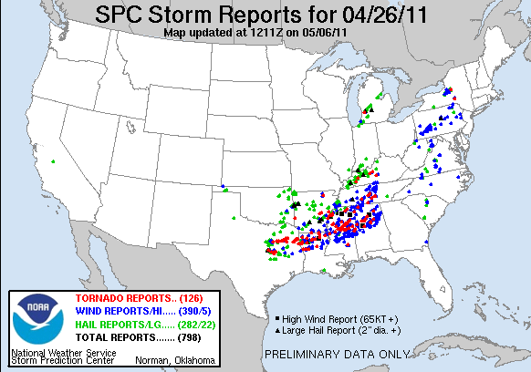
Here was April 26, 2011 in the end. EXTREMELY active, yet it would only get MUCH worse!!!
0 likes
Return to “USA & Caribbean Weather”
Who is online
Users browsing this forum: AnnularCane and 58 guests