Texas Spring 2024

U.S. & Caribbean Weather Discussions and Severe Weather Events

Moderator: S2k Moderators

Forum rules

The posts in this forum are NOT official forecast and should not be used as such. They are just the opinion of the poster and may or may not be backed by sound meteorological data. They are NOT endorsed by any professional institution or STORM2K.

Help Support Storm2K
Message
Author
snownado
Tropical Storm
Tropical Storm
Posts: 115
Joined: Sat Dec 09, 2023 7:00 pm
Location: Plano, TX

Re: Texas Spring 2024

#1021 Postby snownado » Sat May 04, 2024 4:14 pm

Stratton23 wrote:After this weekends rain, id he fine with not seeing anymore rain for a few weeks , exceeded over 8 inches here, send the rest to central or west texas, se texas does not need anymore rain, unless you live at the coast


^^^Amen to that!!!
0 likes   

User avatar
bubba hotep
S2K Supporter
S2K Supporter
Posts: 5526
Joined: Wed Dec 28, 2016 1:00 am
Location: Collin County Texas

Re: Texas Spring 2024

#1022 Postby bubba hotep » Sat May 04, 2024 4:45 pm

rwfromkansas wrote:
bubba hotep wrote:FWD expanded the flood watch to include all of the DFW metro area.


Is tonight’s rain still supposed to be south of DFW?

Their updated graphic only shows .50-1.00 total for most of DFW.


Models are all over the place but the 18z 3k NAM would deliver

Image
1 likes   
Winter time post are almost exclusively focused on the DFW area.

User avatar
bubba hotep
S2K Supporter
S2K Supporter
Posts: 5526
Joined: Wed Dec 28, 2016 1:00 am
Location: Collin County Texas

Re: Texas Spring 2024

#1023 Postby bubba hotep » Sat May 04, 2024 4:50 pm

Looks like another big tornado on the ground in SW TX
0 likes   
Winter time post are almost exclusively focused on the DFW area.

User avatar
bubba hotep
S2K Supporter
S2K Supporter
Posts: 5526
Joined: Wed Dec 28, 2016 1:00 am
Location: Collin County Texas

Re: Texas Spring 2024

#1024 Postby bubba hotep » Sat May 04, 2024 4:53 pm

2 likes   
Winter time post are almost exclusively focused on the DFW area.

HockeyTx82
S2K Supporter
S2K Supporter
Posts: 2008
Joined: Tue Oct 27, 2009 11:17 am
Location: Ponder, TX

Re: Texas Spring 2024

#1025 Postby HockeyTx82 » Sat May 04, 2024 6:32 pm


Not quite sure why, but there's something very majestic about a tornado out in the open plains or desert.
3 likes   
Don't hold me accountable for anything I post on this forum. Leave the real forecasting up to the professionals.

Location: Ponder, TX (all observation posts are this location unless otherwise noted)

User avatar
Edwards Limestone
S2K Supporter
S2K Supporter
Posts: 373
Age: 35
Joined: Tue Dec 28, 2021 11:05 am
Location: Smithson Valley, TX

Re: Texas Spring 2024

#1026 Postby Edwards Limestone » Sat May 04, 2024 8:11 pm

Kinda losing the faith down south after another day of sweltering humidity with no precip. CAMs look like maybe 1-1.5” for my area with a quick line moving through overnight. Suppose I shouldn’t complain.

It’s amazing the difference between north/central and south/central TX the last week.
1 likes   
The above post is NOT an official forecast and should not be used as such. It is just the opinion of the poster and may or may not be backed by sound meteorological data. It is NOT endorsed by any professional institution including Storm2k. For official information, please refer to NWS products.

User avatar
bubba hotep
S2K Supporter
S2K Supporter
Posts: 5526
Joined: Wed Dec 28, 2016 1:00 am
Location: Collin County Texas

Re: Texas Spring 2024

#1027 Postby bubba hotep » Sat May 04, 2024 8:46 pm

00z HRRR gets a lot of people rain overnight and into tomorrow morning.

Image
3 likes   
Winter time post are almost exclusively focused on the DFW area.

User avatar
Edwards Limestone
S2K Supporter
S2K Supporter
Posts: 373
Age: 35
Joined: Tue Dec 28, 2021 11:05 am
Location: Smithson Valley, TX

Re: Texas Spring 2024

#1028 Postby Edwards Limestone » Sat May 04, 2024 8:52 pm

bubba hotep wrote:00z HRRR gets a lot of people rain overnight and into tomorrow morning.

https://m2o.pivotalweather.com/maps/models/hrrr/2024050500/040/qpf_acc-imp.us_sc.png


Definitely an improvement over the 23z for south TX
2 likes   
The above post is NOT an official forecast and should not be used as such. It is just the opinion of the poster and may or may not be backed by sound meteorological data. It is NOT endorsed by any professional institution including Storm2k. For official information, please refer to NWS products.

User avatar
bubba hotep
S2K Supporter
S2K Supporter
Posts: 5526
Joined: Wed Dec 28, 2016 1:00 am
Location: Collin County Texas

Re: Texas Spring 2024

#1029 Postby bubba hotep » Sat May 04, 2024 9:31 pm

Image

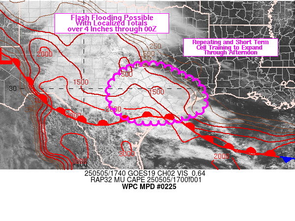
Mesoscale Precipitation Discussion 0225
NWS Weather Prediction Center College Park MD
1012 PM EDT Sat May 04 2024

Areas affected...west-central to central TX

Concerning...Heavy rainfall...Flash flooding likely

Valid 050211Z - 050800Z

Summary...Flash flooding is likely to continue over portions of
west-central into central TX over the next 6 hours. Some
significant flash flooding will be possible, especially over
central TX, west of I-35 and south of I-20 where an additional 3
to 6+ inches is expected through 08Z.

Discussion...0145Z radar imagery over TX showed areas of
widespread thunderstorms within a messy distribution of convection
and surface boundaries. An MCV was noted over the southeastern TX
Panhandle, tracking toward the northeast, parallel to a slow
moving cold front which was preceded by a broken region of
thunderstorms. In addition, slow moving thunderstorms were noted
over central TX, north of a composite outflow boundary that
extended from near TPL, west-southwest to just north of 6R6.
Instability of 1000 to 2000+ J/kg was in place across TX,
supported by steep 700-500 mb lapse rates of 8-9 C/km as sampled
by 00Z soundings from DRT, MAF and FWD.

Large scale lift ahead of a shortwave trough, tracking east across
NM, will continue to overspread a large portion of TX overnight,
with highly divergent/diffluent flow aloft setting up over
portions of central TX, within the right entrance and left exit
regions of associated upper level jet maxima. Precipitable water
values have increased into the 1.5 to 1.7 inch range for much of
the region ahead of the cold front and southeasterly winds at 850
mb are forecast by the RAP to sustain at roughly 20-30 kt,
supporting lift atop rain-cooled air at the surface.

Eventual congealing into a more organized MCS is expected through
06Z, but with the longest residence time of heavy rainfall
occurring for the region of central TX south of I-20 and west of
I-35, where rainfall rates of 2 to 3+ in/hr will be most likely to
continue within areas of training and cell mergers. Portions of
central TX are more sensitive to flash flooding due to recent
rainfall and the addition of another 3 to 6+ inches could lead to
areas of significant flash flooding. Farther north, the track of
the MCV into southern OK may support a narrow stripe of heavier
rainfall near the slow moving frontal boundary. Farther west,
across southern portions of the Permian Basin, a supercell
tracking into Crockett and Val Verde counties is expected to
continue toward the east while convective development, along the
southwestern edge of the expected MCS, potentially leads to
training for portions of the Hill Country overnight.

Otto

ATTN...WFO...EWX...FWD...HGX...LUB...MAF...OUN...SJT...

ATTN...RFC...ABRFC...WGRFC...NWC...
0 likes   
Winter time post are almost exclusively focused on the DFW area.

User avatar
ElectricStorm
Category 5
Category 5
Posts: 4593
Age: 23
Joined: Tue Aug 13, 2019 11:23 pm
Location: Skiatook, OK / Norman, OK

Re: Texas Spring 2024

#1030 Postby ElectricStorm » Sat May 04, 2024 10:27 pm

Welp... 0z model suite is a little more concerning than I expected it to be. Hoping the cap stays strong and cloud cover stays down here because that's gonna be a nasty environment if we end up getting supercells. Might be trending towards a nocturnal event too

Luckily CAMs at 48hrs out can be a little wonky. Interested to read the SPC discussion tonight
1 likes   
I am in no way a professional. Take what I say with a grain of salt as I could be totally wrong. Please refer to the NHC, NWS, or SPC for official information.

Boomer Sooner!

User avatar
bubba hotep
S2K Supporter
S2K Supporter
Posts: 5526
Joined: Wed Dec 28, 2016 1:00 am
Location: Collin County Texas

Re: Texas Spring 2024

#1031 Postby bubba hotep » Sat May 04, 2024 10:29 pm

Wow, some super impressive cloud to ground lightning out there tonight!
0 likes   
Winter time post are almost exclusively focused on the DFW area.

HockeyTx82
S2K Supporter
S2K Supporter
Posts: 2008
Joined: Tue Oct 27, 2009 11:17 am
Location: Ponder, TX

Re: Texas Spring 2024

#1032 Postby HockeyTx82 » Sat May 04, 2024 10:33 pm

bubba hotep wrote:Wow, some super impressive cloud to ground lightning out there tonight!


Yeah, my mom lives in Carrollton. I just got off the phone with her after ter the hockey game ended in overtime. She was just telling me about it. They're in the middle of it right now.
0 likes   
Don't hold me accountable for anything I post on this forum. Leave the real forecasting up to the professionals.

Location: Ponder, TX (all observation posts are this location unless otherwise noted)

User avatar
ElectricStorm
Category 5
Category 5
Posts: 4593
Age: 23
Joined: Tue Aug 13, 2019 11:23 pm
Location: Skiatook, OK / Norman, OK

Re: Texas Spring 2024

#1033 Postby ElectricStorm » Sun May 05, 2024 1:33 am

Day 2 moderate :eek:
Image
1 likes   
I am in no way a professional. Take what I say with a grain of salt as I could be totally wrong. Please refer to the NHC, NWS, or SPC for official information.

Boomer Sooner!

mmmmsnouts
Tropical Depression
Tropical Depression
Posts: 66
Joined: Tue Sep 05, 2023 10:04 pm
Location: Arlington, TX

Re: Texas Spring 2024

#1034 Postby mmmmsnouts » Sun May 05, 2024 2:15 am

This is wild - 3 feet of hail east of San Angelo reported by NWS in a flash flood warning:

https://kamala.cod.edu/offs/KSJT/2405050134.wgus54.html
1 likes   

Cpv17
Category 5
Category 5
Posts: 4372
Joined: Wed Dec 07, 2016 2:24 pm
Location: Wharton/El Campo, TX

Re: Texas Spring 2024

#1035 Postby Cpv17 » Sun May 05, 2024 2:19 am

ElectricStorm wrote:Day 2 moderate :eek:
https://i.imgur.com/lu7GcmG.gif


Pretty rare stuff right there. Looking like an all week event too.
0 likes   

DallasAg
Tropical Storm
Tropical Storm
Posts: 159
Joined: Sun Feb 14, 2021 11:20 am
Location: Dallas, TX

Re: Texas Spring 2024

#1036 Postby DallasAg » Sun May 05, 2024 7:52 am

bubba hotep wrote:00z HRRR gets a lot of people rain overnight and into tomorrow morning.

https://m2o.pivotalweather.com/maps/models/hrrr/2024050500/040/qpf_acc-imp.us_sc.png

3.74" IMBY North Dallas about 5 miles ENE from KDAL. Seems like Dallas County has consistently been the winner this spring. Hopefully a drier week ahead.

Tbh, the last 3-4 weeks have reminded me of what I remember spring being like in Texas when I was growing up (Plano), especially with all of the activity that west Texas has been getting. Daily severe weather, mostly way west of us, organizing into squall lines or MCS that sweep in over night. In various forms or fashions through June. In a world where nothing is like it used to be, it's nice to see something familiar.

Now if Mother Nature can find a way to fill in the holes for those who've missed out hopefully we can enter summer with enough of a surplus to stave off the heat dome or at least delay its onset.
1 likes   

Fifty Rock
Tropical Depression
Tropical Depression
Posts: 50
Joined: Mon Sep 11, 2023 10:08 am
Location: Albany, Texas

Re: Texas Spring 2024

#1037 Postby Fifty Rock » Sun May 05, 2024 8:34 am

Can’t seem to find rainfall totals for shackelford county texas
0 likes   

User avatar
bubba hotep
S2K Supporter
S2K Supporter
Posts: 5526
Joined: Wed Dec 28, 2016 1:00 am
Location: Collin County Texas

Re: Texas Spring 2024

#1038 Postby bubba hotep » Sun May 05, 2024 8:43 am

Fifty Rock wrote:Can’t seem to find rainfall totals for shackelford county texas


Try this site - https://www.texmesonet.org/

Or this - https://maps.cocorahs.org/
0 likes   
Winter time post are almost exclusively focused on the DFW area.

rwfromkansas
Category 5
Category 5
Posts: 2222
Joined: Sat Aug 27, 2005 12:47 am
Location: North Fort Worth

Re: Texas Spring 2024

#1039 Postby rwfromkansas » Sun May 05, 2024 8:50 am

mmmmsnouts wrote:This is wild - 3 feet of hail east of San Angelo reported by NWS in a flash flood warning:

https://kamala.cod.edu/offs/KSJT/2405050134.wgus54.html


I haven’t seen any photos of this. I call shenanigans.

If there was 3 feet, there would be photos.

3 inches I could see.
1 likes   

rwfromkansas
Category 5
Category 5
Posts: 2222
Joined: Sat Aug 27, 2005 12:47 am
Location: North Fort Worth

Re: Texas Spring 2024

#1040 Postby rwfromkansas » Sun May 05, 2024 8:58 am

About 1.65 IMBY. It poured for awhile.

Dallas got clobbered so unfortunately just missed DFW.

So nice to sleep to rain. Reminds me of June as a kid in Kansas. Overnight rain a lot.
2 likes   


Return to “USA & Caribbean Weather”

Who is online

Users browsing this forum: Google Adsense [Bot] and 11 guests