Spring weather outlook Prelim. will upadte later
Ok no map first of all but this is my ideas. As to what i have seen thus far this winter pattern was ever so changing nothign did lock it looked to lock but never did. NAO all over the place. AO tanked out for 2 or 3 times but quickly letup. PNA ridging didnt help. Pac Jet dominance of the Normal Pac Jet and Subtropical Pac Jet. Made it one of the hardest winters to forecast. Thus leaving myself open for this spring and summer. I am however concerned hugely on tornadic weather this spring from the Texas Pandhandle to the Great Lakes and all the way even down to South West Florida. (Very Rare for Tornadic weather in Southwest Florida but not unheard of since water spouts do happen) But I feel April and May will have loads of them. Basic Severe Weather East of the App. Mountian range. But This year will feature lots of higher wind reports and hail reports as the dynamics are even greater. I am also thinking this way due to signs of El Nino have shown partly back up but due to the winter where it didnt form or develope like expected it threw alot of the forecastings off. Cooler then normal Ocean water temps off the east coast also will play a roll in killing severe thunderstorms making it all the way towards the coast east of the moutnians. Expect an Early Cool period of time in the Upper Western States. As SST's are still cool up there cooler then normal. And with a Early Spring/Late Winter Cold dome of high pressure has setup in Canada. Alot can ride with that. I also worry about an Early April Snow event from lets say Baltimore,MD to Portland Maine. In the April 3rd to 11th time frame. But quickly after that the warmth pumps right on up. I Also see a Bermudah high Summer like setting up for middle of spring. Near Summer like temps in May will or should occure in the East. But i do feel we can have a more wetter then normal spring and summer in the eastern 1/3 of the country above Raliegh,NC Drough worries will be another key to worry about in the central part of the country down to Southwest and South East Excluding Florida.
Spring Summer Outlook Prelim. 2004 Sorry Off Topic wise.
Moderator: S2k Moderators
Forum rules

The posts in this forum are NOT official forecast and should not be used as such. They are just the opinion of the poster and may or may not be backed by sound meteorological data. They are NOT endorsed by any professional institution or STORM2K.
-
LMolineux
- Category 1

- Posts: 297
- Joined: Sat Jun 14, 2003 7:25 pm
- Location: Outside of Philadelphia Delaware County Villanova Bryn Mawr Elevation 391'
- Contact:
As Stated in my Discussion here. Some idicies of the NAO And where i have become to some of my conclusions. As you see i said neg. NAO dominance here is the graphic per CPC.

This shows some of my generalized thoughts and why i came to my spring and summer outlook. I am basing this off of many factors.
Also the PNA how i made this outlook how it is mostly pos. to netural.

Also the AO.
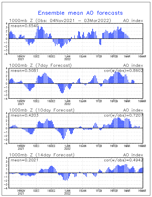
As you see how it is netural and isnt to killer active at this point but its slightly pos.
This shows some of my generalized thoughts and why i came to my spring and summer outlook. I am basing this off of many factors.
Also the PNA how i made this outlook how it is mostly pos. to netural.
Also the AO.
As you see how it is netural and isnt to killer active at this point but its slightly pos.
0 likes
Return to “USA & Caribbean Weather”
Who is online
Users browsing this forum: AnnularCane and 65 guests