Dennis
El Nino, La Nina?
Moderator: S2k Moderators
Forum rules

The posts in this forum are NOT official forecast and should not be used as such. They are just the opinion of the poster and may or may not be backed by sound meteorological data. They are NOT endorsed by any professional institution or STORM2K.
-
azsnowman

- Category 5

- Posts: 8591
- Joined: Wed Feb 05, 2003 8:56 pm
- Location: Pinetop Arizona. Elevation 7102' (54 miles west of NM border)
El Nino, La Nina?
O'TAY weather fans....what's this winter gonna be, a El Nino Year and a La Nina Year?
Dennis
Dennis
0 likes

Dennis, 2004-05 is shaping up to be a weak El Nino winter. I expect El Nino conditions to come on at some point during the early part of the fall (tail end of the tropical season), however the effects of which probably WONT be felt until NOV or DEC at the earliest.
What does this mean for AZ precip wise? Well we can use two methods to figure that out. Those two methods being CLIMO (For ALL weak El Nino events since 1950), or base it off of our preliminary analogs for this coming winter.
Our analogs would suggest Normal to somewhat above normal precipitation over the SW and 4-0 corners region this winter—which is ALSO in touch w/ climo for weak EL NINO years. There are other global indices to take into consideration; however it will take some time to iron out exactly what their influence might be.
This EL NINO will probably be atypical of those which many have become accustomed to during the 80s and 90s due to Pacific re-adjustment (back to the long-term –PDO cycle). That can not only affect the intensity of the El Nino it’s self but also regulate the position of the greatest positive SSTA relative to normal over the equatorial pacific. The west QBO may also suggest the EL NINO event is slower to develop.
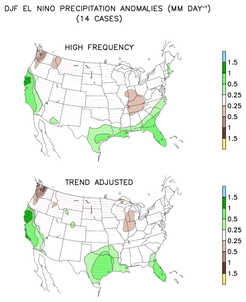
Below are DEC-FEB Precipitation anomalies in El Nino winters:
What does this mean for AZ precip wise? Well we can use two methods to figure that out. Those two methods being CLIMO (For ALL weak El Nino events since 1950), or base it off of our preliminary analogs for this coming winter.
Our analogs would suggest Normal to somewhat above normal precipitation over the SW and 4-0 corners region this winter—which is ALSO in touch w/ climo for weak EL NINO years. There are other global indices to take into consideration; however it will take some time to iron out exactly what their influence might be.
This EL NINO will probably be atypical of those which many have become accustomed to during the 80s and 90s due to Pacific re-adjustment (back to the long-term –PDO cycle). That can not only affect the intensity of the El Nino it’s self but also regulate the position of the greatest positive SSTA relative to normal over the equatorial pacific. The west QBO may also suggest the EL NINO event is slower to develop.
Below are DEC-FEB Precipitation anomalies in El Nino winters:
0 likes

-
Aslkahuna

- Professional-Met

- Posts: 4549
- Joined: Thu Feb 06, 2003 5:00 pm
- Location: Tucson, AZ
- Contact:
The last weak Niño in 2002-03 didn't result in any gain in rainfall in AZ the only wet period occurred in February. Worse yet, pre and post Niño monsoons tend to begin late and are atypical in their distribution of rainfall as well as the occurrence of same. The overriding pattern as of late has been the Drought itself since we are in a feedback loop that is perpetuating it-a loop that prevents good rainfall from occurring here. Until we break this loop, then we will not see any improvement in the situation. We are now 7 years into the Drought. The 70's Drought was about that length but the 50's Drought lasted over 10 years and Drought has lasted as long as 40 years here.
Steve
Steve
0 likes