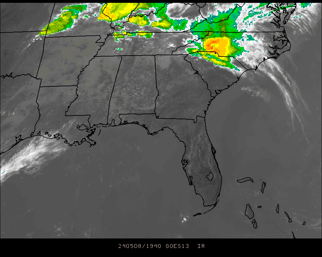
You do NOT want to see that in Alabama ...
Moderator: S2k Moderators
Forum rules

The posts in this forum are NOT official forecast and should not be used as such. They are just the opinion of the poster and may or may not be backed by sound meteorological data. They are NOT endorsed by any professional institution or STORM2K.
-
Stormsfury

- Category 5

- Posts: 10549
- Age: 53
- Joined: Wed Feb 05, 2003 6:27 pm
- Location: Summerville, SC
You do NOT want to see that in Alabama ...
Classic V-shaped configuration to the thunderstorms on IR satellite imagery ... SVR WX w/embedded supercellular action and isolated TVS (tornadic vorticity signatures) coming in from the region tonight ...
0 likes
-
SouthernWx
It's very unusual to see a severe wx event of this magnitude in the south during October....especially the middle of October.
I've seen tornadic supercells during the past 24-30 hours that were more reminiscent of April than October....extremely intense rotating storms.
It just makes me wonder whats ahead in November and December....after a record breaking September for tornadoes, and the most significant October tornado outbreak in my memory across the mid-south and Tennessee valley.
0 likes
-
JuliannaMKH

- Tropical Depression

- Posts: 71
- Age: 52
- Joined: Fri Sep 10, 2004 9:49 am
- Location: Alabama
- Contact:
It was a noisy night and no mistaking it. I woke up several times due to the loud thunder. One of the local mets agreed with you, SouthernWx, saying it was more like spring than fall. He also added that temperatures would be above average for the next 30 days or so. I guess no more crisp weather for us down here for a while.
0 likes
-
Wnghs2007

- Category 5
- Posts: 6836
- Age: 36
- Joined: Wed Mar 24, 2004 11:14 pm
- Location: Gwinnett-Barrow Line; Georgia
- Contact:
JuliannaMKH wrote:It was a noisy night and no mistaking it. I woke up several times due to the loud thunder. One of the local mets agreed with you, SouthernWx, saying it was more like spring than fall. He also added that temperatures would be above average for the next 30 days or so. I guess no more crisp weather for us down here for a while.
Yes it was a very scarry situation for those who live in Alabama. Luckily I was in NE gerogia and was spared
0 likes
-
yoda

- Category 5
- Posts: 7874
- Joined: Tue Jan 13, 2004 3:51 pm
- Location: Springfield VA (20 mins south of DC)
- Contact:
Wnghs2007 wrote:yoda wrote:Yep, you are right SF. No one wants to see that. Very impressive storm system for this time in October...
Hey matt do you think that there will be anymore of these?
Possibly. It will depend on how long these warm temps want to stay and when the next cold front comes through. Someone said something about Friday... let me check Day 3 SPC...
0 likes
-
Wnghs2007
- Category 5
- Posts: 6836
- Age: 36
- Joined: Wed Mar 24, 2004 11:14 pm
- Location: Gwinnett-Barrow Line; Georgia
- Contact:
yoda wrote:Wnghs2007 wrote:yoda wrote:Yep, you are right SF. No one wants to see that. Very impressive storm system for this time in October...
Hey matt do you think that there will be anymore of these?
Possibly. It will depend on how long these warm temps want to stay and when the next cold front comes through. Someone said something about Friday... let me check Day 3 SPC...
Ok thanks Matt.
0 likes
-
yoda
- Category 5
- Posts: 7874
- Joined: Tue Jan 13, 2004 3:51 pm
- Location: Springfield VA (20 mins south of DC)
- Contact:
http://www.spc.noaa.gov/products/outlook/day3otlk.html
...THERE IS A SLGT RISK OF SVR TSTMS FROM EASTERN OK AND MUCH OF
AR...ACROSS THE MID/UPPER MS VALLEY...
ETA/GFS SOLUTIONS ARE IN GOOD AGREEMENT THAT POWERFUL SHORTWAVE
TROUGH WILL SURGE EASTWARD ACROSS THE CENTRAL PLAINS ON
FRIDAY...INTO THE MID MS VALLEY BY 23/12Z. THIS WILL LIKELY SET THE
STAGE FOR A RELATIVELY ACTIVE SEVERE WEATHER EPISODE ACROSS PARTS OF
IA/MO/IL/AR.
DEEP SURFACE LOW WILL MOVE FROM WESTERN KS INTO IA BY FRIDAY
AFTERNOON. VERY STRONG SOUTHERLY LOW LEVEL WINDS AHEAD OF LOW WILL
TRANSPORT MOIST/UNSTABLE AIRMASS NORTHWARD WITH DEWPOINTS IN THE
MID/UPPER 60S LIKELY AS FAR NORTH AS CENTRAL IA. STRONG DAYTIME
HEATING IS ALSO EXPECTED ALONG AND WEST OF THE DRYLINE...ALLOWING
AIRMASS TO BECOME AT LEAST MODERATELY UNSTABLE FROM EASTERN
KS/WESTERN MO INTO WESTERN/CENTRAL IA /MLCAPE VALUES OF 1500-2500
J/KG/. SCATTERED THUNDERSTORMS ARE FORECAST TO DEVELOP ALONG THE
DRYLINE OVER WESTERN MO...AND NEAR SURFACE LOW/WARM FRONT OVER IA.
VERTICAL SHEAR PROFILES WILL BE VERY FAVORABLE FOR SUPERCELL STORMS
CAPABLE OF HAIL/WIND AND POSSIBLY TORNADOES. SOUTHWARD DEVELOPMENT
OF STORMS IS LIKELY AFTER 00Z INTO MUCH OF MO/AR AS LARGE SCALE
FORCING SPREADS EASTWARD INTO MOIST AXIS. PORTIONS OF IA/MO MAY
REQUIRE AN UPGRADE IN LATER OUTLOOKS.
0 likes
-
Wnghs2007
- Category 5
- Posts: 6836
- Age: 36
- Joined: Wed Mar 24, 2004 11:14 pm
- Location: Gwinnett-Barrow Line; Georgia
- Contact:
yoda wrote:http://www.spc.noaa.gov/products/outlook/day3otlk.html
...THERE IS A SLGT RISK OF SVR TSTMS FROM EASTERN OK AND MUCH OF
AR...ACROSS THE MID/UPPER MS VALLEY...
ETA/GFS SOLUTIONS ARE IN GOOD AGREEMENT THAT POWERFUL SHORTWAVE
TROUGH WILL SURGE EASTWARD ACROSS THE CENTRAL PLAINS ON
FRIDAY...INTO THE MID MS VALLEY BY 23/12Z. THIS WILL LIKELY SET THE
STAGE FOR A RELATIVELY ACTIVE SEVERE WEATHER EPISODE ACROSS PARTS OF
IA/MO/IL/AR.
DEEP SURFACE LOW WILL MOVE FROM WESTERN KS INTO IA BY FRIDAY
AFTERNOON. VERY STRONG SOUTHERLY LOW LEVEL WINDS AHEAD OF LOW WILL
TRANSPORT MOIST/UNSTABLE AIRMASS NORTHWARD WITH DEWPOINTS IN THE
MID/UPPER 60S LIKELY AS FAR NORTH AS CENTRAL IA. STRONG DAYTIME
HEATING IS ALSO EXPECTED ALONG AND WEST OF THE DRYLINE...ALLOWING
AIRMASS TO BECOME AT LEAST MODERATELY UNSTABLE FROM EASTERN
KS/WESTERN MO INTO WESTERN/CENTRAL IA /MLCAPE VALUES OF 1500-2500
J/KG/. SCATTERED THUNDERSTORMS ARE FORECAST TO DEVELOP ALONG THE
DRYLINE OVER WESTERN MO...AND NEAR SURFACE LOW/WARM FRONT OVER IA.
VERTICAL SHEAR PROFILES WILL BE VERY FAVORABLE FOR SUPERCELL STORMS
CAPABLE OF HAIL/WIND AND POSSIBLY TORNADOES. SOUTHWARD DEVELOPMENT
OF STORMS IS LIKELY AFTER 00Z INTO MUCH OF MO/AR AS LARGE SCALE
FORCING SPREADS EASTWARD INTO MOIST AXIS. PORTIONS OF IA/MO MAY
REQUIRE AN UPGRADE IN LATER OUTLOOKS.
UH OH
0 likes


-
Stormsfury
- Category 5
- Posts: 10549
- Age: 53
- Joined: Wed Feb 05, 2003 6:27 pm
- Location: Summerville, SC
Return to “USA & Caribbean Weather”
Who is online
Users browsing this forum: Iceresistance and 89 guests