MODERATE risk for parts of Texas?

U.S. & Caribbean Weather Discussions and Severe Weather Events

Moderator: S2k Moderators

Forum rules

The posts in this forum are NOT official forecast and should not be used as such. They are just the opinion of the poster and may or may not be backed by sound meteorological data. They are NOT endorsed by any professional institution or STORM2K.

Help Support Storm2K
Message
Author
User avatar
wxman22
Category 5
Category 5
Posts: 1493
Joined: Mon Jan 30, 2006 12:39 am
Location: Wichita Falls, TX
Contact:

MODERATE risk for parts of Texas?

#1 Postby wxman22 » Thu Apr 20, 2006 4:13 am

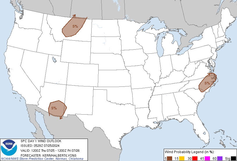
Image

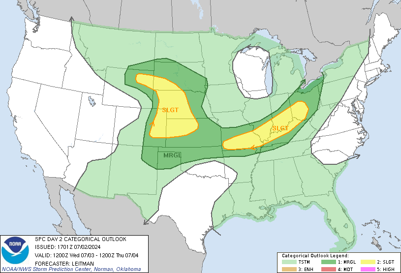
Image

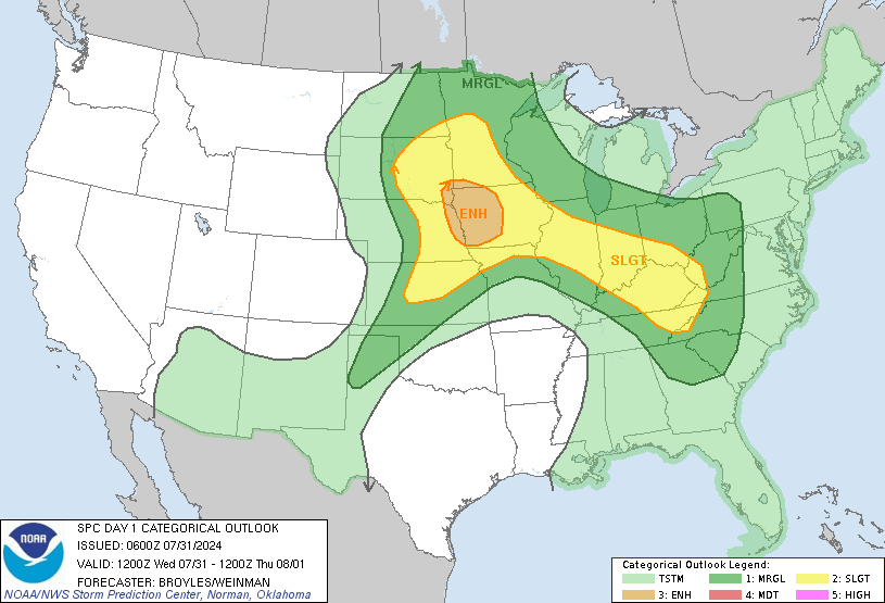
Image

[img]http://www.spc.noaa.gov/products/outlook/day1probotlk_1200_wind.gif[img]

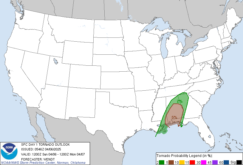
DAY 1 CONVECTIVE OUTLOOK
NWS STORM PREDICTION CENTER NORMAN OK
0106 AM CDT THU APR 20 2006

VALID 201200Z - 211200Z

...THERE IS A SLGT RISK OF SVR TSTMS FROM TX ACROSS THE LOWER MS
VALLEY TO SRN KY...TN...WRN GA...

...SYNOPSIS...
SPRINGTIME CUTOFF LOW ACROSS THE UPPER MS VALLEY WILL MAKE ONLY SLOW
EWD PROGRESS TOWARD THE WRN GREAT LAKES THIS PERIOD AS A LOWER
AMPLITUDE AND MORE PROGRESSIVE IMPULSE IN THE SRN BRANCH MOVES EAST
FROM AZ/NM TO THE ARKLATEX. DOWNSTREAM FROM THE SRN BRANCH
IMPULSE...A MORE SUBTLE AND POTENTIALLY CONVECTIVELY ENHANCED SHORT
WAVE DISTURBANCE IS FORECAST TO TRACK EAST FROM THE SRN
PLAINS...ACROSS THE LOWER MS VALLEY...AND THEN TO THE CNTRL
APPALACHIANS THROUGH LATE TONIGHT. THE TWO SRN STREAM PERTURBATIONS
WILL ENHANCE ASCENT ALONG A QUASI-STATIONARY FRONTAL ZONE WHICH WILL
REMAIN SITUATED WITHIN A VERY WARM AND MOIST AIRMASS FROM TX TO TN.

...LOWER MS VALLEY/TN VALLEY...
ONGOING LARGE MCS FROM NRN TX TO AR WILL MOVE EWD FROM THE ARKLATEX
THROUGH THE MORNING SUSTAINED BY WEAK TO MODEST MOISTURE FLUX AND
ASCENT OCCURRING ACROSS STALLED DEEP-LAYER FRONTAL ZONE. GUIDANCE
APPEARS TO SUGGEST THAT A FRONTAL WAVE COINCIDENT WITH THIS COMPLEX
WILL PROPAGATE ENEWD ALONG THE FRONTAL BOUNDARY ACROSS THE LOWER MS
VALLEY AND INTO THE TN VALLEY THROUGH THE DAY WITH LARGE SCALE
ASCENT ACROSS THESE AREAS ENHANCED BY POSSIBLE MCV. RELATIVELY
UNDISTURBED WARM SECTOR AIR MASS SHOULD EXIST EAST OF THE
APPROACHING MCS...AND WEST OF RESIDUAL BACK DOOR FRONT/MCS
OUTFLOW...FROM MIDDLE TN TO NRN MS. EXPECT MODERATELY UNSTABLE
CONDITIONS TO DEVELOP ALONG THE FRONT IN THIS REGION THROUGH THE
MORNING GIVEN SUFFICIENT HEATING. FORCING ASSOCIATED WITH THE
APPROACHING WAVE SHOULD PROMOTE ADDITIONAL SURFACE-BASED TSTM
DEVELOPMENT FROM NRN MS/WRN TN...EWD ACROSS MIDDLE TN AND NRN AL
THROUGH THE AFTERNOON. FORECAST SOUNDINGS ACROSS THE REGION APPEAR
TO INDICATE WEAK EFFECTIVE SHEAR ACROSS THE WARM SECTOR INITIALLY
WHICH MAY RESULT IN GREATER CONCENTRATION OF MULTICELL STORMS WITH
SOME HAIL POTENTIAL. HOWEVER...MID LEVEL FLOW AND DEEP SHEAR
STRENGTHEN DURING THE AFTERNOON SO STORMS MAY BECOME BETTER
ORGANIZED ALONG THE FRONT AND NEAR SURFACE WAVE. THUS... EXPECT
ORGANIZED MULTICELLS AND PERHAPS A COUPLE OF SUPERCELLS SPREADING
EAST ACROSS THE REGION THROUGH THE AFTERNOON. THIS ACTIVITY WILL BE
CAPABLE OF PRODUCING LARGE HAIL AND DAMAGING WINDS. TORNADO
POTENTIAL MAY ALSO EVOLVE WITH CELLS TRACKING PREFERENTIALLY NEAR
THE FRONT...AND ACROSS THE RESIDUAL OUTFLOW BOUNDARY WHERE LOW LEVEL
FLOW WILL BE LOCALLY BACKED AND STRONGER SHEAR WILL LIKELY EXIST.

ANOTHER FOCUS FOR STORM DEVELOPMENT MAY EXIST FROM SRN GA WWD ACROSS
SRN AL AND MS BY LATE AFTERNOON. A SEGMENT OF RESIDUAL FRONT/OUTFLOW
MAY MOVE INTO THESE AREAS WHERE DIURNAL HEATING WILL BOOST CAPE BUT
REGION MAY REMAIN CAPPED UNTIL LATER IN THE DAY. MODEST MID LEVEL
FLOW WILL PROMOTE ORGANIZED STORMS DEVELOPING IN THIS REGIME WITH
ATTENDANT THREAT OF HAIL AND WIND. WITH DIURNAL FORCING BEING THE
PRIMARY FACTOR IN THE DEVELOPMENT OF THIS ACTIVITY...EXPECT SEVERE
POTENTIAL TO GRADUALLY WANE AFTER SUNSET.

...WEST TX TO THE ARKLATEX...
FRONTAL ZONE FROM HILL COUNTRY TO ARKLATEX WILL REMAIN WELL DEFINED
IN THE WAKE OF OVERNIGHT/MORNING MCS. AIR MASS ALONG AND SOUTH OF
THE FRONT IS EXPECTED TO BECOME INCREASINGLY UNSTABLE THROUGH THE
DAY WITH 60S DEWPOINTS AND STEEP MID LEVEL LAPSE RATES CONTRIBUTING
TO MLCAPE OF 1500-2000 J/KG. HEIGHT FALLS AND LARGE SCALE ASCENT
WITH APPROACHING SRN BRANCH SHORT WAVE TROUGH SHOULD INDUCE SURFACE
PRESSURE FALLS ACROSS WRN TX WITH WARM SECTOR POSSIBLY EXPANDING NWD
AS LOW LEVEL SELY FLOW STRENGTHENS AHEAD OF DEEPENING TRIPLE POINT
SURFACE WAVE AND SHARPENING DRYLINE.

FORECAST SOUNDINGS ACROSS THE REGION ARE INDICATING 40-45KT
EFFECTIVE SHEAR NEAR THE FRONT...AND DEVELOPING EWD ACROSS THE WARM
SECTOR INTO THE EVENING. GIVEN EXPECTED FORCING AND
INSTABILITY...ENVIRONMENT SHOULD SUPPORT THE DEVELOPMENT OF
SUPERCELLS CAPABLE OF PRODUCING LARGE...POSSIBLY

SIGNIFICANT... HAIL. ANY DISCRETE STORMS TRACKING NEAR/ALONG THE WSW-ESE ORIENTED
FRONTAL BOUNDARY...OR NEAR SURFACE WAVE...COULD ALSO POSE A THREAT
FOR TORNADOES WHERE LOW-LEVEL SHEAR AND BOUNDARY LAYER RH WILL BE
MAXIMIZED. STORMS MAY UNDERGO UPSCALE ORGANIZATION INTO AN MCS
THROUGH THE LATE EVENING AND DAMAGING WIND POTENTIAL MAY INCREASE AS
THIS MCS SPREADS EAST TOWARD THE GULF COAST THROUGH EARLY FRIDAY[/b]IT IS POSSIBLE THAT SEVERE WEATHER PROBABILITIES MAY BE
INCREASED...AND CATEGORICAL OUTLOOK COULD BE UPGRADED...ACROSS
PORTIONS OF TX AS EVOLUTION OF SEVERE WEATHER SCENARIO BECOMES MORE
CERTAIN WITH ADDITIONAL SHORT-TERM ANALYSIS AND FORECAST DATA.

..CARBIN/JEWELL.. 04/20/2006
0 likes   

User avatar
Extremeweatherguy
Category 5
Category 5
Posts: 11095
Joined: Mon Oct 10, 2005 8:13 pm
Location: Florida

#2 Postby Extremeweatherguy » Thu Apr 20, 2006 6:17 am

uh oh! Sounds good to me! :D I just hope some severe weather can make it to Houston! Today/Tomorrow are going to fun days for weather.

BTW...you forgot to post the wind probabilities image:

Image
0 likes   

CrazyC83
Professional-Met
Professional-Met
Posts: 34002
Joined: Tue Mar 07, 2006 11:57 pm
Location: Deep South, for the first time!

#3 Postby CrazyC83 » Thu Apr 20, 2006 9:54 am

I'd say large hail is the biggest threat. I don't see more than a few isolated tornadoes.
0 likes   

User avatar
jasons2k
Storm2k Executive
Storm2k Executive
Posts: 8245
Age: 51
Joined: Wed Jul 06, 2005 12:32 pm
Location: The Woodlands, TX

#4 Postby jasons2k » Thu Apr 20, 2006 10:23 am

I hope we finally get some soaking rains and some good thunder out of this.

My only concern is the timing. I'm afraid an MCS will form, push towards SE Texas overnight, and just as it gets here, it falls apart....stabilizes the air....then the front moves out tomorrow before we get a chance to "recharge" again. I REALLY hope that's not what happens, but it's happened 1,000 times it seems, and I wonder if that's why the NWS won't go above 30% for us here.
0 likes   

User avatar
Yankeegirl
Category 5
Category 5
Posts: 3417
Age: 49
Joined: Sun May 23, 2004 11:59 pm
Location: Cy-Fair, Northwest Houston
Contact:

#5 Postby Yankeegirl » Thu Apr 20, 2006 10:40 am

I gotta work tomorrow... It always gets busy when it rains... Oh well, my yard needs it...
0 likes   

User avatar
wxman22
Category 5
Category 5
Posts: 1493
Joined: Mon Jan 30, 2006 12:39 am
Location: Wichita Falls, TX
Contact:

#6 Postby wxman22 » Thu Apr 20, 2006 11:39 am

...
TX INTO THE LOWER MS RIVER VALLEY...
COMPLEX EVOLUTION ANTICIPATED ACROSS TX TODAY. STRONG UPPER LOW IS
NOW MOVING INTO THE SRN HIGH PLAINS...WITH SUBSEQUENT MID/UPPER
LEVEL JET OVERSPREADING TX. SURFACE PATTERN IS QUITE MESSY DUE TO
EARLIER CONVECTION...THOUGH EXPECT PRIMARY SURFACE WARM FRONT WILL
BECOME BETTER DEFINED FROM THE UPPER TX COAST INTO THE HILL COUNTRY
DURING THE AFTERNOON. SOUTH OF THIS BOUNDARY RICH GULF MOISTURE
REMAINS IN PLACE WITH SURFACE DEW POINTS AROUND 70F.

SLY LLJ OBSERVED ON MORNING UPPER AIR ANALYSES WILL REMAIN ANCHORED
INTO THE BIG BEND REGION/EDWARDS PLATEAU THROUGH THE DAY AND
MAINTAIN ELEVATED STRONG TO SEVERE THUNDERSTORMS INTO WRN AND NWRN
TX. ACTIVITY NOW ONGOING IN THE HILL COUNTRY NEAR THE FRONT MAY
BECOME INCREASINGLY SURFACE BASED AND PERSIST EWD INTO CENTRAL TX
THROUGH THE AFTERNOON. OTHER VIGOROUS DEVELOPMENT IS EXPECTED TO
OCCUR NEARER THE DRY LINE AND AHEAD OF STRONG UPPER LOW INTO
SWRN/CENTRAL TX LATER TODAY. THIS ACTIVITY WILL BECOME INCREASINGLY
WIDESPREAD WITH INITIAL DEVELOPMENT AS SUPERCELLS AND ORGANIZED
CLUSTERS. VERY LARGE HAIL AND A FEW TORNADOES SHOULD ACCOMPANY
THESE STORMS. SUPERCELLS MAY PERSIST NEAR THE FRONT...THOUGH


OVERALL ACTIVITY SHOULD MORPH INTO ONE OR TWO LARGE MCSS AND SPREAD
INCREASED SEVERE THREAT EWD TOWARDS THE MIDDLE TX COAST AND ERN TX
THROUGH THE EVENING/OVERNIGHT.
:larrow: That catches my eye I wonder if Southeast Texas will be put in a moderate risk?....
0 likes   

User avatar
jasons2k
Storm2k Executive
Storm2k Executive
Posts: 8245
Age: 51
Joined: Wed Jul 06, 2005 12:32 pm
Location: The Woodlands, TX

#7 Postby jasons2k » Thu Apr 20, 2006 1:01 pm

"That catches my eye I wonder if Southeast Texas will be put in a moderate risk?...."

I doubt it. When these events evolve like that into an MCS the primary threat becomes straight-line winds when storms bow out or a derecho forms. I've never seen a mod. risk for a wind event. I think any threat of a Mod risk will be W or NW of here during the afternoon hours.
Last edited by jasons2k on Thu Apr 20, 2006 1:02 pm, edited 1 time in total.
0 likes   

Johnny
Category 5
Category 5
Posts: 1428
Joined: Thu Jul 10, 2003 1:35 pm
Location: No Snow For You, Texas

#8 Postby Johnny » Thu Apr 20, 2006 1:01 pm

Convection really starting to fire up in West Central, Texas.


http://radar.wunderground.com/data/640x ... adarc3.gif
0 likes   

User avatar
cctxhurricanewatcher
Category 5
Category 5
Posts: 1206
Joined: Sun Sep 12, 2004 8:53 pm
Location: Corpus Christi, Texas

#9 Postby cctxhurricanewatcher » Thu Apr 20, 2006 1:01 pm

"OVERALL ACTIVITY SHOULD MORPH INTO ONE OR TWO LARGE MCSS AND SPREAD
INCREASED SEVERE THREAT EWD TOWARDS THE MIDDLE TX COAST AND ERN TX
THROUGH THE EVENING/OVERNIGHT. That catches my eye I wonder if Southeast Texas will be put in a moderate risk?...."

I like the trend as long as it comes with an inch or two or rain.
0 likes   

User avatar
southerngale
Retired Staff
Retired Staff
Posts: 27418
Joined: Thu Oct 10, 2002 1:27 am
Location: Southeast Texas (Beaumont area)

#10 Postby southerngale » Thu Apr 20, 2006 1:38 pm

There are burn bans in the area here. I hope we get a good bit of rain out of this. The cows are giving evaporated milk.
0 likes   

Johnny
Category 5
Category 5
Posts: 1428
Joined: Thu Jul 10, 2003 1:35 pm
Location: No Snow For You, Texas

#11 Postby Johnny » Thu Apr 20, 2006 2:05 pm

A few tornado warnings and severe thunderstorm warnings now out for parts of the Hill Country.


http://iwin.nws.noaa.gov/iwin/tx/warnings.html
0 likes   

User avatar
Extremeweatherguy
Category 5
Category 5
Posts: 11095
Joined: Mon Oct 10, 2005 8:13 pm
Location: Florida

#12 Postby Extremeweatherguy » Thu Apr 20, 2006 2:49 pm

jschlitz wrote:"That catches my eye I wonder if Southeast Texas will be put in a moderate risk?...."

I doubt it. When these events evolve like that into an MCS the primary threat becomes straight-line winds when storms bow out or a derecho forms. I've never seen a mod. risk for a wind event. I think any threat of a Mod risk will be W or NW of here during the afternoon hours.
A derecho would be a moderate risk for sure! Derechos carry a wide swath of damaging winds and gusts have been known to top 115mph within them. If a strong derecho formed then that would certaintly be cause for concern. I don't think the chances are high of a large derecho like that though.
0 likes   

User avatar
Extremeweatherguy
Category 5
Category 5
Posts: 11095
Joined: Mon Oct 10, 2005 8:13 pm
Location: Florida

#13 Postby Extremeweatherguy » Thu Apr 20, 2006 2:56 pm

Latest from the SPC (2:46pm update):

...TX...

A LARGE CLUSTER OF THUNDERSTORMS HAS EVOLVED FROM THE HILL COUNTRY
OF CNTRL TX INTO THE TX SOUTH PLAINS NEAR LBB. THIS ACTIVITY IS
DRIVEN IN LARGE PART DUE TO LOW LEVEL WARM ADVECTION ATOP ENTRENCHED
COOLER LOW LEVEL BOUNDARY LAYER WHERE ENELY SFC WINDS PERSIST. LLJ
WILL REMAIN FOCUSED INTO SWRN TX FOR THE NEXT FEW HOURS BEFORE
GRADUALLY VEERING INTO CNTRL TX LATER THIS EVENING. IN THE SHORT
TERM...CONTINUED HEATING WILL BE REQUIRED OVER NRN MEXICO...EWD
ALONG THE WARM FRONT BEFORE MORE ROBUST WARM SECTOR CONVECTION WILL
EVOLVE. UPDRAFT CLUSTERS ARE GRADUALLY LOWERING JUST NORTH OF THE
WIND SHIFT OVER GILLESPIE COUNTY TX...WITH A NOTABLE EWD PROPAGATION
ALIGNED ALONG FRONTAL ORIENTATION. SHEAR PROFILES REMAIN FAVORABLE
FOR SUPERCELL DEVELOPMENT AND WITH TIME POTENTIALLY
TORNADIC...ALTHOUGH LARGE HAIL SHOULD BE THE PRIMARY SEVERE THREAT.
LATER TONIGHT...CLUSTER MERGERS AND GRADUALLY VEERING WINDS WITH
HEIGHT SHOULD ENHANCE FORWARD PROPAGATION COMPONENT AND DAMAGING
WINDS MAY BECOME MORE OF AN ISSUE AS MCS EVOLVES AND SPREADS TOWARD
THE MIDDLE/UPPER TX COAST.


Going to be an interesting and potentially sleepless night!
0 likes   

conestogo_flood
Category 5
Category 5
Posts: 1268
Joined: Wed Sep 28, 2005 5:49 pm

#14 Postby conestogo_flood » Thu Apr 20, 2006 3:09 pm

Image

MESOSCALE DISCUSSION 0585
NWS STORM PREDICTION CENTER NORMAN OK
0258 PM CDT THU APR 20 2006

AREAS AFFECTED...SW THRU CNTRL TX

CONCERNING...SEVERE THUNDERSTORM WATCH 219...220...

VALID 201958Z - 202100Z

SEVERE WEATHER WATCHES WILL LIKELY BE REPLACED WITH A NEW TORNADO
WATCH BEFORE 21Z.


SOUTHERN STREAM SHORT WAVE TROUGH IS FINALLY BEGINNING TO PROGRESS
EAST OF THE SOUTHERN ROCKIES...AND LEADING EDGE OF STRONGER
MID-LEVEL COOLING IS ALREADY OVERSPREADING THE TRANS PECOS REGION.
THIS...IN CONJUNCTION WITH CONTINUED WARMING OF BOUNDARY LAYER SOUTH
OF OUTFLOW ENHANCED SURFACE FRONT...IS CONTRIBUTING TO WEAKENING
INHIBITION. MIXED LAYER CAPE ALONG/SOUTH OF FRONT IS CURRENTLY IN
EXCESS OF 1500 J/KG...AND WILL INCREASE FURTHER THROUGH THE
REMAINDER OF THE AFTERNOON. DRY LINE/FRONTAL INTERSECTION SHIFTING
FROM SOUTH OF MIDLAND THROUGH THE JUNCTION AREA BETWEEN 20/21-21/00Z
SEEMS MOST PROBABLE FOCUS FOR INTENSE SURFACE BASED CONVECTIVE
DEVELOPMENT. WIND PROFILES EXHIBITING PRONOUNCED VEERING WITH
HEIGHT IN LOWER-LEVELS WILL BE FAVORABLE FOR
SUPERCELLS...PARTICULARLY AS 50 KT 500 MB SPEED MAXIMUM NOSES ACROSS
SOUTHWEST TEXAS. RISK OF TORNADOES IS EXPECTED TO INCREASE...ALONG
WITH CONTINUING THREAT FOR LARGE HAIL.

..KERR.. 04/20/2006
0 likes   

User avatar
southerngale
Retired Staff
Retired Staff
Posts: 27418
Joined: Thu Oct 10, 2002 1:27 am
Location: Southeast Texas (Beaumont area)

#15 Postby southerngale » Thu Apr 20, 2006 3:12 pm

Extreme SE TX has just about fallen off the Day 1 maps since any threat shouldn't be until early Friday morning. Not as detailed as the Day 1 maps, but here's Day 2:

Image


Image
0 likes   

User avatar
Extremeweatherguy
Category 5
Category 5
Posts: 11095
Joined: Mon Oct 10, 2005 8:13 pm
Location: Florida

#16 Postby Extremeweatherguy » Thu Apr 20, 2006 4:11 pm

NW Houston is still in the DAY 1 Slight Risk area though. I feel that we will start to see a few pop up storm this evening in this area followed by a "main blast" sometime between 10pm and 3am.

http://www.spc.noaa.gov/products/outlook/day1otlk.html
0 likes   

User avatar
jasons2k
Storm2k Executive
Storm2k Executive
Posts: 8245
Age: 51
Joined: Wed Jul 06, 2005 12:32 pm
Location: The Woodlands, TX

#17 Postby jasons2k » Thu Apr 20, 2006 4:32 pm

I'm still concerned about the timing as posted above. Even with 60% pops now, the specific forecast says mainly after 1AM tonight and mainly before 1PM tomorrow. That's about the worst window for us hoping for some action down here. I just hope we get at least something!
0 likes   

User avatar
Portastorm
Storm2k Moderator
Storm2k Moderator
Posts: 9914
Age: 63
Joined: Fri Jul 11, 2003 9:16 am
Location: Round Rock, TX
Contact:

#18 Postby Portastorm » Thu Apr 20, 2006 4:35 pm

I think the MODERATE RISK is above my house right now.

Very stormy here in Austin at the moment. Seems like we have a warning in every county around here. We can use the rain but not the hail!
0 likes   

User avatar
Extremeweatherguy
Category 5
Category 5
Posts: 11095
Joined: Mon Oct 10, 2005 8:13 pm
Location: Florida

#19 Postby Extremeweatherguy » Thu Apr 20, 2006 4:46 pm

jschlitz wrote:I'm still concerned about the timing as posted above. Even with 60% pops now, the specific forecast says mainly after 1AM tonight and mainly before 1PM tomorrow. That's about the worst window for us hoping for some action down here. I just hope we get at least something!
I was just outside and noticed that some of the clouds were beginning to get some height and "puff" to them. they are also developing greyish bases and look like they want to become thunderstorms so badly. I have also noticed some turbulance along the underside of a few of the clouds (the same kind of turbulance I would see in a severe storm), I wonder if this is a sign of things to come? Personally, I believe a few storms WILL begin to fire much earlier than 1am, and then the worst of it will proabably come between 11pm and 7am. Wind and hail look to be our primary threats. So pretty much my timeline is:

Now to 7pm: Puffy clouds, hot...a few storms possibly developing.

7pm to 11pm: Isolated supercells forming from I-45 westward...30% chance of storms in NW Houston.

11pm to 2am: Increasing storm coverage and intensity. Squall line forming to our NW.

3am to 7am: Sometime within this period, the squall line should pass through (although I would not be surprised if it either was faster or slower and it could come as early as 11pm-midnight or as late as noon Friday).
0 likes   

User avatar
Portastorm
Storm2k Moderator
Storm2k Moderator
Posts: 9914
Age: 63
Joined: Fri Jul 11, 2003 9:16 am
Location: Round Rock, TX
Contact:

#20 Postby Portastorm » Thu Apr 20, 2006 5:13 pm

Just had a major hailstorm here in north Austin. Hail size at my house ranged from pea to golfball. Wow!
0 likes   


Return to “USA & Caribbean Weather”

Who is online

Users browsing this forum: No registered users and 23 guests