
Holy crap!
Moderator: S2k Moderators
Forum rules

The posts in this forum are NOT official forecast and should not be used as such. They are just the opinion of the poster and may or may not be backed by sound meteorological data. They are NOT endorsed by any professional institution or STORM2K.
Holy crap!
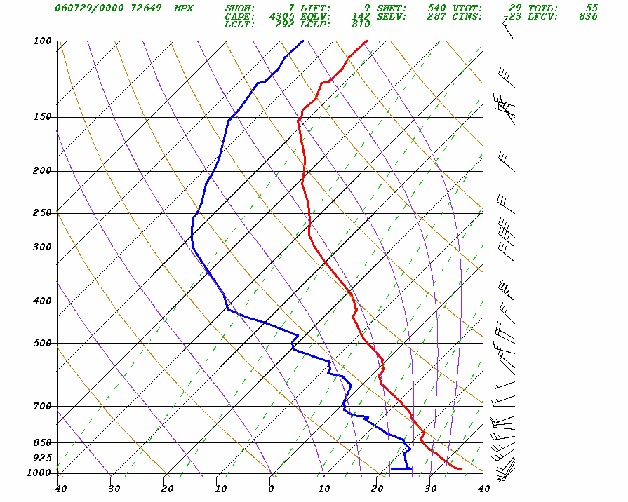
look at the sounding out of MPX at midnight. LI's up to -9 and cape in excess of 4000! this might not be uncommon for TX/OK, but we're talking about central Minnesota! a pretty strong cold front is moving through my area, so with any luck, we'll have a fun night and or day tomorrow.
0 likes
-
Jim Cantore
wxmann_91 wrote:Not at all unusual. With temps and dewpoints this high, it really isn't a surprise to see that type of a 'loaded gun' sounding, even at midnight. Of course, under a ridge, you've got inhibition and limited lift, which is keeping things in check right now.
It's happened all month here
July 2nd: Event, Bow Echo, Cause 90 Degrees + 65-70 dew points
July 4th: Event, Bow Echo, Cause, 90 degrees + 65-70 dew points
July 18th: Event, Bow Echo, Cause 104 degrees + 67 dew point
July 22nd: Event, Severe storm, Cause 85 degrees + 65 dew point
July 21st: Event, Severe storm, Cause High humidity kicked up by Beryl
July 27th-28th: Event 3 severe storms, cause, 90 degree temps, 70-75 dew points
it's been happening... often
6 in the last 11 days
0 likes
-
WindRunner

- Category 5

- Posts: 5803
- Age: 35
- Joined: Fri Jul 29, 2005 8:07 pm
- Location: Warrenton, VA, but Albany, NY for school
- Contact:
SPC just upgraded to a MOD risk for the area around the ND/SD/MN corner, with a 45% wind/hatched 30% hail/5% tor for the area, as well as a tornado watch up, as "rapid severe thunderstorm development is expected" in the next couple of hours. It's going to be a volatile situation if/when the storms start to fire.
0 likes
-
WindRunner
- Category 5
- Posts: 5803
- Age: 35
- Joined: Fri Jul 29, 2005 8:07 pm
- Location: Warrenton, VA, but Albany, NY for school
- Contact:
Link to the KABR RUC2 sounding for 20Z. LI is -7 and CAPE tops 5000 (and tops 6000 by 23Z), and the low-level shear is quite impressive.
Java-based soundings 20Z-23Z
Java-based soundings 20Z-23Z
0 likes
-
wxmann_91

- Category 5
- Posts: 8007
- Age: 34
- Joined: Fri Jul 15, 2005 2:49 pm
- Location: Southern California
- Contact:
Today's situation is a much more volatile situation. We have a boundary draped across the MN/ND/SD border which is setting up conditions favorable for strong to violent tornadoes. Take a look at this ob plot and you'll see what I'm talking about:

Talk about moisture pooling and backing of winds along the OFB!! That will seriously
a) lower LCL's
b) enhance SRH and CAPE/EHI
If we can have sfc-based initation that rides along the boundary, that area will need to be watched.
Talk about moisture pooling and backing of winds along the OFB!! That will seriously
a) lower LCL's
b) enhance SRH and CAPE/EHI
If we can have sfc-based initation that rides along the boundary, that area will need to be watched.
0 likes
-
wxmann_91
- Category 5
- Posts: 8007
- Age: 34
- Joined: Fri Jul 15, 2005 2:49 pm
- Location: Southern California
- Contact:
Despite the INSANE parameters, it looks like the cap may win again. CU are failing to form, and CINH is once again increasing as the boundary layer begins to decouple tonight.
EDIT: BTW, latest Mesoanalysis showing 7500 SBCAPE, 250 0-1 km SRH, and 0-1 km EHI's of 13 (0-3 km EHI's of over 20!) in northeastern SD. Ahh, the miracles of moisture pooling!
EDIT: BTW, latest Mesoanalysis showing 7500 SBCAPE, 250 0-1 km SRH, and 0-1 km EHI's of 13 (0-3 km EHI's of over 20!) in northeastern SD. Ahh, the miracles of moisture pooling!
0 likes
-
WindRunner
- Category 5
- Posts: 5803
- Age: 35
- Joined: Fri Jul 29, 2005 8:07 pm
- Location: Warrenton, VA, but Albany, NY for school
- Contact:
CrazyC83 wrote:That MDT definitely busted...perhaps the biggest bust this year?
nope, believe it or not, we've had bigger moderate risk busts here in the Twin Cities this year, one day that included a 10% risk for tornadoes and a 30% risk for hail for i think 2 outlooks, and then everything that was forecasted to happen in the Twin Cities in those two outlooks was shifted way to the south into Iowa.
0 likes
-
CrazyC83
- Professional-Met

- Posts: 34315
- Joined: Tue Mar 07, 2006 11:57 pm
- Location: Deep South, for the first time!
dean wrote:CrazyC83 wrote:That MDT definitely busted...perhaps the biggest bust this year?
nope, believe it or not, we've had bigger moderate risk busts here in the Twin Cities this year, one day that included a 10% risk for tornadoes and a 30% risk for hail for i think 2 outlooks, and then everything that was forecasted to happen in the Twin Cities in those two outlooks was shifted way to the south into Iowa.
Yes, but they produced severe weather elsewhere - this one did nothing at all.
0 likes
CrazyC83 wrote:dean wrote:CrazyC83 wrote:That MDT definitely busted...perhaps the biggest bust this year?
nope, believe it or not, we've had bigger moderate risk busts here in the Twin Cities this year, one day that included a 10% risk for tornadoes and a 30% risk for hail for i think 2 outlooks, and then everything that was forecasted to happen in the Twin Cities in those two outlooks was shifted way to the south into Iowa.
Yes, but they produced severe weather elsewhere - this one did nothing at all.
not yet, but it is still possible that the front may trigger storms in central MN early in the morning.
0 likes
-
wxmann_91
- Category 5
- Posts: 8007
- Age: 34
- Joined: Fri Jul 15, 2005 2:49 pm
- Location: Southern California
- Contact:
CrazyC83 wrote:dean wrote:CrazyC83 wrote:That MDT definitely busted...perhaps the biggest bust this year?
nope, believe it or not, we've had bigger moderate risk busts here in the Twin Cities this year, one day that included a 10% risk for tornadoes and a 30% risk for hail for i think 2 outlooks, and then everything that was forecasted to happen in the Twin Cities in those two outlooks was shifted way to the south into Iowa.
Yes, but they produced severe weather elsewhere - this one did nothing at all.
Usually in such volatile situations something has to give, even if it is in the middle of the night. This is what's going on right now. A strengthening LLJ has provided sufficient lift for parcels to break through the cap, reach their LFC, and thus initiate convection.
Got a couple of TOR's and supercells in the Duluth area now. Of course, I'm betting that with the decoupled boundary layer and nearly 0 SBCAPE, along with -500 CINH (
EDIT: Just now a tornado was reported and a tornado watch was issued. LOL.
0 likes
-
WindRunner
- Category 5
- Posts: 5803
- Age: 35
- Joined: Fri Jul 29, 2005 8:07 pm
- Location: Warrenton, VA, but Albany, NY for school
- Contact:
The directional shear was better yesterday afternoon, with similar speeds. I don't think today will be any better than yesterday unless the cap is weaker (or the storms stronger). SPC is hilighting the northern MN/WI/MI area with 30% hail, which probably has a better chance of verifying today than anything yesterday.
0 likes
-
conestogo_flood
- Category 5
- Posts: 1268
- Joined: Wed Sep 28, 2005 5:49 pm
Return to “USA & Caribbean Weather”
Who is online
Users browsing this forum: Edwards Limestone, txtwister78 and 65 guests