


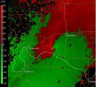
A pronounced meso couplet can be seen on this velocity scan (2:04am CST) as it was passing through the town of Newburgh producing strong F3 damage (200 mph) and moving at a forward speed of 70 mph.
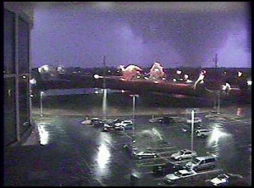
The only known photo of the wedge tornado taken by Deaconess Women's Hospital webcam during a lightning strike around 2am, about the time it was causing most of the fatalities at the Eastbrook Mobile Home Park.
PUBLIC INFORMATION STATEMENT
NATIONAL WEATHER SERVICE PADUCAH KY
439 PM CST THU NOV 2 2006
...ONE YEAR ANNIVERSARY OF THE EVANSVILLE TORNADO COMING UP
NOVEMBER 6TH...
DURING THE PRE DAWN HOURS OF NOVEMBER 6 2005...A TORNADO TORE A
DEADLY PATH ACROSS NORTHWEST KENTUCKY AND SOUTHWEST INDIANA. THIS
TORNADO WAS A TRAGEDY THAT WILL LONG BE REMEMBERED FOR THE LOSS
OF LIFE AND DESTRUCTION INFLICTED ON AREA RESIDENTS.
AROUND 139 AM...THE TORNADO TOUCHED DOWN IN RURAL NORTHERN HENDERSON
COUNTY...ABOUT 2 MILES NORTHWEST OF THE TINY COMMUNITY OF SMITH
MILLS. THE TORNADO RACED EAST NORTHEAST AT CLOSE TO 70 MPH THROUGH
THE SPARSELY POPULATED FLOOD PLAIN OF THE OHIO RIVER. SHORTLY
AFTER CROSSING THE OHIO RIVER NEAR THE U.S. HIGHWAY 41 TWIN
BRIDGES...THE TORNADO STRUCK RELATIVELY POPULATED AREAS ON THE
FRINGES OF EVANSVILLE AND HENDERSON. THE VAST MAJORITY OF THE
FATALITIES OCCURRED AT A MOBILE HOME PARK ON THE SOUTH SIDE OF
INTERSTATE 164...JUST OUTSIDE THE EVANSVILLE CITY LIMIT. TWENTY
PERSONS WERE KILLED AT THE MOBILE HOME PARK...MANY CAUGHT WHILE THEY
WERE SLEEPING. THE TORNADO TOOK FOUR MORE LIVES AS IT TORE A 21 MILE
PATH ACROSS WARRICK COUNTY. THE TORNADO LIFTED AT 224 AM...SHORTLY
AFTER EXITING INTO SPENCER COUNTY.
DURING ITS 45 MINUTE LIFESPAN...THIS F3 TORNADO LEFT A PATH OF
DAMAGE 41 MILES LONG AND UP TO 500 YARDS WIDE. THERE WERE 24
DEATHS AND OVER 200 INJURIES. THIS REMAINS THE DEADLIEST SINGLE
INDIANA TORNADO SINCE APRIL 3 1974...THE DATE OF A SUPER OUTBREAK.
THIS EVENT SERVES AS A REMINDER THAT THE LOWER OHIO VALLEY IS
VULNERABLE TO TORNADOES AT ALMOST ANY TIME OF YEAR. WHILE APRIL
AND MAY ARE PEAK TORNADO MONTHS IN OUR REGION...DEADLY OUTBREAKS
HAVE OCCURRED IN SUCH MONTHS AS NOVEMBER AND DECEMBER. JUST OVER A
MONTH AGO...A VIOLENT F4 TORNADO STRUCK PERRY COUNTY MISSOURI ON
SEPTEMBER 22...THE FIRST KNOWN F4 TORNADO IN SEPTEMBER IN OUR 58
COUNTY SERVICE AREA.
FOR MORE INFORMATION ON TORNADO PREPAREDNESS OR NATIONAL WEATHER
SERVICE PROGRAMS AND SERVICES...PLEASE CONTACT...
RICK SHANKLIN
WARNING COORDINATION METEOROLOGIST
WFO PADUCAH KENTUCKY
270.559.2724
FOR MORE INFORMATION ABOUT PAST TORNADOES OR TORNADO CLIMATOLOGY
IN OUR REGION...PLEASE VISIT OUR WEBSITE AT WEATHER.GOV/PADUCAH...OR
YOU MAY CONTACT...
MIKE YORK
FORECASTER / STORM DATA PROGRAM LEADER
WFO PADUCAH KENTUCKY
270.744.0321
For more information on the Evansville tornado, including path maps and photos, please visit:
http://www.crh.noaa.gov/pah/?n=evansvil ... nov.6,2005[/b]


