Here's the new thread, I didn't get all creative with the title though.
This is the latest from Jeff:
Classic spring severe weather pattern shaping up for the plains for the next several days.
Discussion:
Main issue today will be the wind as pressures fall in the lee of the Rockies and SE wind greatly increases over TX. Already getting gust near 40 over W TX and suspect with thermal mixing some area will gust above 50mph W of I-35. Over SE TX sustained speeds of 20-25mph will be common by afternoon. Strong onshore flow will continue through Friday afternoon with gulf seas building to 4-8 feet due to long southerly fetch. South wind flow should negate tidal build up as typically ESE and E winds result in the higher tides due to Ekman transport. With that said building wave action may result in some tidal run-up at times of high tide. Low level jet will crank every evening and continue overnight with area terminals experiencing strong speed shear in the lowest levels of the atmosphere.
Dryline is sharpening over W TX through the central plains with very moist southerly flow extending from TX into South Dakota. Dryline will fire off by late afternoon with tornadoes being the threat in a linear line from WC TX through Kansas. Ejection of multiple short waves ahead of main upper low over SW US should result in daily severe threat over TX mainly W of I-35 through Friday. Threat may shift far enough east Friday night to include SE TX as main upper storm ejects into the central plains dragging the dryline toward the area. Will focus on this part of the forecast as this appears to be the main “action” time.
Active weather event should develop by Friday afternoon as strong lift ejects out of Mexico into SW TX where moist southerly flow with unstable and potentially high sheared air mass will be in place. Expect Mexican capping layer to erode by mid afternoon along the dryline as temps. climb into the mid to upper 80’s and large scale lift overspreads the region. Supercells should initiate by late afternoon near or east of the Rio Grande and develop/move ENE through Friday night on the edge of the large scale ascent and into favorable low level flow off the Gulf. Hodographs over S and SC TX favor tornadic storms with cells moving to the right of the mean flow (right moving cells). As is typical in such events, supercells will gradually transition into a line or line segments and may grown upscale into an MCS/bow echo as it moves toward the TX coastal bend and SE TX. Strong low level jet of 40-50kts being overspread by 80-80kts of WSW mid level flow should support storm organization and maintain the event through the overnight hours. Expect some form of a squall line/MCS/bow echo to cross SE TX very late Friday evening or Saturday morning with a severe and heavy rainfall threat. Pattern thereafter is somewhat muddled as models are hinting that energy will hang back over the SW US and the dryline will redevelop by Sunday over SW TX ahead of a returning boundary off the TX coast. This could spell problems for Sunday evening into Monday.
Heavy Rainfall:
GFS is suffering from heavy convective feedback bombs and is producing excessive rainfall over NW and C TX. Dryline position over the next 3 days will remain along and W of I-35 with the focus for very heavy daily rains along and W of I-35 and generally N of Austin. Max QPF from HPC is focused over the middle and upper Brazos basin which is on the rise from heavy rains on Monday. Excessive rainfall over the Brazos and Colorado basins may result in significant downstream main stem rises and potential problems given already swollen rivers and saturated grounds. Locally rainfall Friday night should result in a widespread 1-2 inches which should be handled as long as the line progresses through and does not slow.
Jeff Lindner
SE TX/SW LA Discussion Thread - Mid 80's and sunny this week
Moderator: S2k Moderators
Forum rules

The posts in this forum are NOT official forecast and should not be used as such. They are just the opinion of the poster and may or may not be backed by sound meteorological data. They are NOT endorsed by any professional institution or STORM2K.
-
jasons2k

- Storm2k Executive

- Posts: 8290
- Age: 52
- Joined: Wed Jul 06, 2005 12:32 pm
- Location: The Woodlands, TX
SE TX/SW LA Discussion Thread - Mid 80's and sunny this week
Last edited by jasons2k on Thu Apr 26, 2007 11:15 am, edited 8 times in total.
0 likes
-
Extremeweatherguy

- Category 5

- Posts: 11095
- Joined: Mon Oct 10, 2005 8:13 pm
- Location: Florida

-
JenBayles

- Category 5
- Posts: 3461
- Age: 63
- Joined: Tue Aug 26, 2003 3:27 pm
- Location: Houston, TX
- Contact:
Yeah, the HGX boyz and girlz backed off the Friday event the past couple of days per model guidance. Another case of model-waffling or will this be another non-event like the last one? Regardless, looks like we'll get some rain, which I'll be happy to get... that is, unless the B.C. Dome cranks up again.
0 likes

We all hope that dome keeps the dryline storms away. Man its kickin in the Panhandle with some classic text book supercells. We are safe from the real supercells here. Hmmmmmm............perhaps the dome will keep us safe during our next hurricane.
0 likes
The following post is NOT an official forecast and should not be used as such. It is just the opinion of the poster and may or may not be backed by sound meteorological data. It is NOT endorsed by any professional institution including storm2k.org For Official Information please refer to the NHC and NWS products.
-
Extremeweatherguy
- Category 5
- Posts: 11095
- Joined: Mon Oct 10, 2005 8:13 pm
- Location: Florida
Though they have backed off some (down from 50% to 40%) on Friday, they have also kicked it up some for Saturday and Sunday (which now have 30-40% pops instead of partly sunny skies). Based on this, I think we will probably see something before it is all over with, and a round or two of severe weather threats still looks possible if what jeff is saying ends up playing out. We hopefully will not get anything like what the panhandle is seeing though.JenBayles wrote:Yeah, the HGX boyz and girlz backed off the Friday event the past couple of days per model guidance. Another case of model-waffling or will this be another non-event like the last one? Regardless, looks like we'll get some rain, which I'll be happy to get... that is, unless the B.C. Dome cranks up again.
0 likes
I second that EWG. The Panhandle has gotten pounded tonight. Extremely impressive supercells.
0 likes
The following post is NOT an official forecast and should not be used as such. It is just the opinion of the poster and may or may not be backed by sound meteorological data. It is NOT endorsed by any professional institution including storm2k.org For Official Information please refer to the NHC and NWS products.
-
PTrackerLA

- Category 5
- Posts: 5281
- Age: 42
- Joined: Thu Oct 10, 2002 8:40 pm
- Location: Lafayette, LA
-
Extremeweatherguy
- Category 5
- Posts: 11095
- Joined: Mon Oct 10, 2005 8:13 pm
- Location: Florida
00z GFS seems to be bullseying early to midday Saturday for our best chance of rain and storms here in SE Texas..
http://www.nco.ncep.noaa.gov/pmb/nwprod ... _066.shtml
Looks like it is trying to bring an MCS feature, possibly in the form of a squall-line, through the Houston area around late morning or noon on Saturday.
However, if the model is right (which I have my doubts about), this feature will not be fast to move out. It is showing it basically stalling over our area through Sunday. Could be interesting.
0 likes
-
Extremeweatherguy
- Category 5
- Posts: 11095
- Joined: Mon Oct 10, 2005 8:13 pm
- Location: Florida
Latest Day 3 outlook from the SPC:
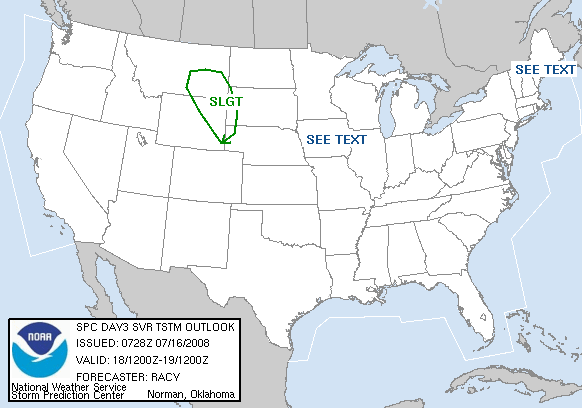
...CENTRAL/ERN TX TO LOWER MS VALLEY...
ONE OR MORE STG-SVR MCS WITH DAMAGING WIND AND LARGE HAIL ARE
POSSIBLE AT BEGINNING OF PERIOD...OVER PORTIONS CENTRAL/SRN TX AND
PERHAPS SERN OK/NRN TX. THIS ACTIVITY...OR ADDITIONAL DEVELOPMENT
ALONG ASSOCIATED BOUNDARIES...MAY BECOME SVR AGAIN DURING AFTERNOON
HOURS ACROSS E TX AND AR...MOVING TOWARD LOWER MS VALLEY REGION.
FCST LOW-MIDLEVEL WIND FIELDS AND PROGGED SOUNDINGS SUGGEST VERTICAL
SHEAR WILL BE FAVORABLE FOR SUPERCELLS AND BOWS WITH THESE
COMPLEXES. GIVEN RICH BOUNDARY LAYER MOISTURE EXPECTED S OF
FRONT/OUTFLOWS...MOST PROBABLE AREA FOR DIURNAL DESTABILIZATION AND
FAVORABLE SFC-BASED BUOYANCY MAY BE OVER E TX AND LA...PERHAPS INTO
PORTIONS WRN/SRN MS.
0 likes
-
Yankeegirl

- Category 5
- Posts: 3417
- Age: 50
- Joined: Sun May 23, 2004 11:59 pm
- Location: Cy-Fair, Northwest Houston
- Contact:
-
Extremeweatherguy
- Category 5
- Posts: 11095
- Joined: Mon Oct 10, 2005 8:13 pm
- Location: Florida
18z GFS shows a large MCS feature hitting SE Texas during the early afternoon of Saturday (which means we will have daytime heating to contend with). Certainly could get interesting...
http://www.nco.ncep.noaa.gov/pmb/nwprod ... _048.shtml
http://www.nco.ncep.noaa.gov/pmb/nwprod ... _048.shtml
^^Saturday late morning/early afternoon^^
http://www.nco.ncep.noaa.gov/pmb/nwprod ... _054.shtml
http://www.nco.ncep.noaa.gov/pmb/nwprod ... _054.shtml
^^Saturday late afternoon/early evening^^
http://www.nco.ncep.noaa.gov/pmb/nwprod ... _048.shtml
http://www.nco.ncep.noaa.gov/pmb/nwprod ... _048.shtml
^^Saturday late morning/early afternoon^^
http://www.nco.ncep.noaa.gov/pmb/nwprod ... _054.shtml
http://www.nco.ncep.noaa.gov/pmb/nwprod ... _054.shtml
^^Saturday late afternoon/early evening^^
0 likes
-
Extremeweatherguy
- Category 5
- Posts: 11095
- Joined: Mon Oct 10, 2005 8:13 pm
- Location: Florida
0z GFS looks even more threatening...
http://www.nco.ncep.noaa.gov/pmb/nwprod ... _036.shtml
http://www.nco.ncep.noaa.gov/pmb/nwprod ... _036.shtml
^^Sat. morning^^
http://www.nco.ncep.noaa.gov/pmb/nwprod ... _042.shtml
http://www.nco.ncep.noaa.gov/pmb/nwprod ... _042.shtml
^^Sat. afternoon^^
http://www.nco.ncep.noaa.gov/pmb/nwprod ... _048.shtml
http://www.nco.ncep.noaa.gov/pmb/nwprod ... _048.shtml
^^Sat. evening^^
Should be interesting to see the SPC day 2 outlook tomorrow morning.
http://www.nco.ncep.noaa.gov/pmb/nwprod ... _036.shtml
http://www.nco.ncep.noaa.gov/pmb/nwprod ... _036.shtml
^^Sat. morning^^
http://www.nco.ncep.noaa.gov/pmb/nwprod ... _042.shtml
http://www.nco.ncep.noaa.gov/pmb/nwprod ... _042.shtml
^^Sat. afternoon^^
http://www.nco.ncep.noaa.gov/pmb/nwprod ... _048.shtml
http://www.nco.ncep.noaa.gov/pmb/nwprod ... _048.shtml
^^Sat. evening^^
Should be interesting to see the SPC day 2 outlook tomorrow morning.
0 likes

-
Yankeegirl
- Category 5
- Posts: 3417
- Age: 50
- Joined: Sun May 23, 2004 11:59 pm
- Location: Cy-Fair, Northwest Houston
- Contact:
-
Extremeweatherguy
- Category 5
- Posts: 11095
- Joined: Mon Oct 10, 2005 8:13 pm
- Location: Florida
AREA FORECAST DISCUSSION
NATIONAL WEATHER SERVICE HOUSTON/GALVESTON TX
304 PM CDT FRI MAR 30 2007
.DISCUSSION...
LEAD SHORTWAVE THAT HAS BEEN PRODUCING SHRA/TSTMS ACROSS CNTRL TX
AND OUR NW ZONES IS PULLING OFF TO THE N AND NE...ALL WHILE
ADDITIONAL DEVELOPMENT IS ONGOING FURTHER NW IN ASSOCIATION WITH THE
MAIN H5 TROF AND FRONTAL BOUNDARY. EXPECT A BREAK IN THE PRECIP THIS
EVENING FOR THE VAST MAJORITY OF THE CWA WHILE THE PRECIP OUT NW
GRADUALLY ORGANIZES INTO A CONVECTIVE COMPLEX/SQUALL LINE. EXPECT
THIS LINE OF STORMS TO ENTER NW/N PORTIONS OF THE AREA AFTER 3 AM.
GOOD LLVL JET SHOULD BE FEEDING THIS SQUALL LINE AND ANTICIPATE SOME
STRONG TO SEVERE STORMS ALONG THE BOUNDARY AS IT APPROACHES. WILL
MENTION POSSIBILITY OF SEVERE STORMS ACROSS LOCATIONS NW OF A
TRINITY TO COLUMBUS LINE UNTIL 6 AM. WILL THEN LET THE MIDNIGHT
SHIFT (OR LATE SWING SHIFT) MAKE THE CALL REGARDING THE SEVERE
POTENTIAL FOR THE PERIODS BEYOND 6 AM AS THEY GET A LOOK AT THE
LATER CONVECTIVE TRENDS. REASONING IS THAT THE BEST DYNAMICS AND
PUSH MOVE OFF TO THE NE TOWARD MORNING. SHOULD THIS OCCUR AND NO
OTHER MESOSCALE FORCING IS IN PLAY...THE LINE OF STORMS *SHOULD*
BEGIN SLOWING AND WEAKEN SOMEWHAT TOWARD MORNING. BUT IF IT DOES
MAINTAIN ITS SEWD MOMENTUM...SVR POTENTIAL WILL EXIST ACROSS THE
ENTIRE CWA. DAMAGING WINDS SHOULD BE THE PRIMARY THREAT...THOUGH
ISOLATED TORNADOES WITHIN THE LINE ARE NOT OUT OF THE QUESTION...ESP
ACROSS NW ZONES. PW`S POOL TO AROUND 1.8" ALONG THE FRONTAL BOUNDARY
SO WILL ALSO MENTION THE LOCALLY HEAVY RAINFALL WORDING...ESP
CONCERNED FOR ANY SLOWING BOUNDARY. DON`T EXPECT ANY WIDESPREAD
FLOOD PROBLEMS CONSIDERING THE GROUND CAN PROBABLY TAKE A GOOD
SOAKING BUT THE USUAL URBAN-TYPE ISSUES MAY CROP UP. WILL UPDATE THE
HWO ACCORDINGLY.
TRENDED THE FCST TOWARD THE GFS WHICH DOES SLOW THE SHALLOW
BOUNDARY`S FORWARD PROGRESS THRU THE DAY SATURDAY AND MAINTAIN GOOD
H85 AND H7 CONVERGENCE THRU THE DAY ACROSS THE SRN 2/3 OF THE
REGION. ANTICIPATE RAIN COMING TO AN END AT THE COAST BY LATE
EVENING AS THE WEAK DISSIPATING FRONTAL BOUNDARY COMES TO REST
OFFSHORE.
THIS BOUNDARY IS FCST BY THE CANADIAN AND GFS TO MOVE BACK INLAND
MON BRINGING PW`S BACK INTO THE 1.8" TERRITORY. BOTH MODELS DEPICT
DECENT PRECIP COVERAGE AS UPPER IMPULSES EJECT OUT OF ANOTHER BAJA
TROF AND MOVE OVERHEAD EARLY NEXT WEEK. NUDGED POPS UP TO AROUND 40%
BUT THIS MAY END UP BEING TOO LOW. STILL LOOKING FOR A FAIRLY STRONG
(BUT MODIFIED) COLD FRONT ASSOCIATED WITH A 1048 MB HIGH IN CANADA
TO PUSH THRU TUES NIGHT. MOSTLY DRY AND COOLER WX FOR THE REMAINDER
OF THE WEEK WITH A NW FLOW ALOFT PREVAILING.
0 likes
-
Extremeweatherguy
- Category 5
- Posts: 11095
- Joined: Mon Oct 10, 2005 8:13 pm
- Location: Florida

MESOSCALE DISCUSSION 0382
NWS STORM PREDICTION CENTER NORMAN OK
0451 PM CDT FRI MAR 30 2007
AREAS AFFECTED...N AND NE TX SSWWD ACROSS THE HILL COUNTRY/EDWARDS
PLATEAU/MIDDLE AND LOWER RIO GRANDE VALLEY
CONCERNING...TORNADO WATCH 92...93...
VALID 302151Z - 302245Z
THE SEVERE WEATHER THREAT FOR TORNADO WATCH 92...93...CONTINUES.
WIDESPREAD THUNDERSTORMS CONTINUE ACROSS N TX AND SSWWD INTO THE
HILL COUNTRY...WHILE MORE ISOLATED STORMS ARE ONGOING FURTHER SWWD
TOWARD THE RIO GRANDE VALLEY. INSTABILITY REMAINS LIMITED OVER THE
NRN HALF OF THIS REGION DUE TO WIDESPREAD PRECIPITATION -- FROM NRN
PORTIONS OF THE HILL COUNTRY NNEWD -- WHERE AOB 500 J/KG MEAN-LAYER
CAPE IS INDICATED. NONETHELESS...AREA VWPS SHOW VEERING/INCREASING
FLOW WITH HEIGHT...RESULTING IN SHEAR PROFILES FAVORABLE FOR BOTH
DEEP MESOCYCLONES AND LOW-LEVEL ROTATION.
FURTHER SSWWD -- FROM THE HILL COUNTRY SWD TO THE MIDDLE/LOWER RIO
GRANDE VALLEY NEAR DRT...GREATER INSTABILITY /FROM 1500 TO 2500 J/KG
MEAN-LAYER CAPE/ REMAINS AS CONVECTION HAS BEEN MUCH MORE ISOLATED.
THOUGH DEEP-LAYER WIND FIELD IS SOMEWHAT WEAKER ACROSS THIS
REGION...DEGREE OF VEERING/SHEAR REMAINS NONETHELESS SUPPORTIVE --
PARTICULARLY GIVEN AMOUNT OF INSTABILITY -- FOR SUPERCELLS. ONE
VERY LARGE SUPERCELL IS OCCURRING OVER CENTRAL VAL VERDE COUNTY
ATTM...WHICH HAS SPAWNED SEVERAL LEFT SPLITS OVER THE PAST COUPLE OF
HOURS.
GIVEN COMBINATION OF INSTABILITY AND SHEAR ACROSS THIS ENTIRE REGION
-- FROM THE NERN QUARTER OF TX AHEAD OF MAIN CONVECTIVE LINE SSWWD
TO THE RIO GRANDE...IT APPEARS THAT THE THREAT FOR TORNADOES ALONG
WITH HAIL/WIND WILL PERSIST FOR SEVERAL HOURS. WITH BOTH WW 92 AND
93 SET TO EXPIRE AT 30/23Z...REPLACEMENT WATCH/WATCHES WILL LIKELY
BE REQUIRED.
..GOSS.. 03/30/2007
ATTN...WFO...HGX...FWD...OUN...EWX...SJT...
0 likes
-
Extremeweatherguy
- Category 5
- Posts: 11095
- Joined: Mon Oct 10, 2005 8:13 pm
- Location: Florida
Return to “USA & Caribbean Weather”
Who is online
Users browsing this forum: No registered users and 128 guests