Florida Weather
Moderator: S2k Moderators
Forum rules

The posts in this forum are NOT official forecast and should not be used as such. They are just the opinion of the poster and may or may not be backed by sound meteorological data. They are NOT endorsed by any professional institution or STORM2K.
-
JonathanBelles
- Professional-Met

- Posts: 11430
- Age: 35
- Joined: Sat Dec 24, 2005 9:00 pm
- Location: School: Florida State University (Tallahassee, FL) Home: St. Petersburg, Florida
- Contact:
Florida Weather
I was gonna make this later..But its raining now!!! its been pouring for about 10 mins now.
Last edited by JonathanBelles on Wed Jun 12, 2013 9:25 pm, edited 193 times in total.
0 likes
-
feederband

- S2K Supporter

- Posts: 3423
- Joined: Wed Oct 01, 2003 6:21 pm
- Location: Lakeland Fl
Re: Florida Seabreeze Thread
fact789 wrote:I was gonna make this later..But its raining now!!! its been pouring for about 10 mins now.
Yeah I see that on radar...We didn't get a drop of rain today....
0 likes
-
mf_dolphin

- Category 5

- Posts: 17758
- Age: 69
- Joined: Tue Oct 08, 2002 2:05 pm
- Location: St Petersburg, FL
- Contact:
-
JonathanBelles
- Professional-Met
- Posts: 11430
- Age: 35
- Joined: Sat Dec 24, 2005 9:00 pm
- Location: School: Florida State University (Tallahassee, FL) Home: St. Petersburg, Florida
- Contact:
-
Aquawind

- Category 5
- Posts: 6714
- Age: 62
- Joined: Mon Jun 16, 2003 10:41 pm
- Location: Salisbury, NC
- Contact:
We finally got a real gully washer here along the coast. It's been so close in recent weeks and goods rains nearby. I was in the pool watching the clouds build almost directly overhead. It was very cool watching the breezes collide and the clouds boil(no thunder) so close and yet in full sun. The usual clear near the coast and eventually it worked it's way to the coast and filled in. The big lake is still below 9' and well below where it should be. Going to the Rush concert in Tampa tonight..with the rain gear..lol
0 likes


Re: Florida Seabreeze Thread
On Friday I was on the beaches driving back to Tampa, when I hit this "extremely heavy shower"... I cant say thunderstorm because I did hear any thunder. When I hit 34th St. it was hammerin down rain... surprised me as I didnt even expect it. Some street flooding on 5th Ave. N too.
Does anyone have a rainfall total from this event?
Does anyone have a rainfall total from this event?
0 likes
-
JonathanBelles
- Professional-Met
- Posts: 11430
- Age: 35
- Joined: Sat Dec 24, 2005 9:00 pm
- Location: School: Florida State University (Tallahassee, FL) Home: St. Petersburg, Florida
- Contact:
W had a very weird t-storm almost get here last night. This storm had 2 cells. One was over my house and it was a dying outflow boundary. It was no larger than a football field, but it had more lighting than it had rain and clouds. The lightning spiderwebbed around the single towering cloud. It disapated just before it got to me., I got all of 4 drops. I got another 2 drops this morning.
0 likes
-
feederband
- S2K Supporter
- Posts: 3423
- Joined: Wed Oct 01, 2003 6:21 pm
- Location: Lakeland Fl
Re:
fact789 wrote:W had a very weird t-storm almost get here last night. This storm had 2 cells. One was over my house and it was a dying outflow boundary. It was no larger than a football field, but it had more lighting than it had rain and clouds. The lightning spiderwebbed around the single towering cloud. It disapated just before it got to me., I got all of 4 drops. I got another 2 drops this morning.
Yeah it put on a lighting show here in Lakeland but once again we missed all the rain...Once again we got a 50% chance today...
0 likes
-
JonathanBelles
- Professional-Met
- Posts: 11430
- Age: 35
- Joined: Sat Dec 24, 2005 9:00 pm
- Location: School: Florida State University (Tallahassee, FL) Home: St. Petersburg, Florida
- Contact:
-
MiamiensisWx
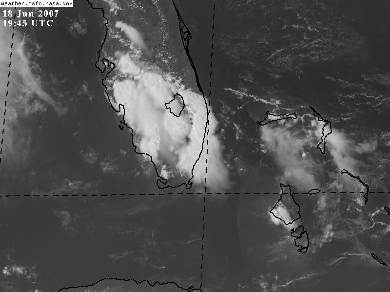
Re: Florida Seabreeze Thread
Decent mid-level moisture has been affecting portions of southern Florida. The Miami radar indicates some slow-moving cells over Palm Beach and Martin counties. Some low-level inflow has been supporting convergence, and upper-level flow allowed the cirrus to spread outward. A sfc convergence boundary has enhanced convective activity. A mid-level disturbance over Louisiana (and subtropical jet impulse) has affected the eastern Gulf of Mexico, too. It is associated with a shortwave trough. It is evident in this loop.
SPECIAL WEATHER STATEMENT
NATIONAL WEATHER SERVICE MIAMI FL
404 PM EDT MON JUN 18 2007
FLZ070-182045-
INLAND COLLIER COUNTY FL-
404 PM EDT MON JUN 18 2007
AT 402 PM EDT...NATIONAL WEATHER SERVICE DOPPLER RADAR INDICATED
STRONG THUNDERSTORMS ALONG A LINE EXTENDING FROM 6 MILES SOUTH OF
HENDRY CORRECTIONAL INSTITUTE TO MILE MARKER 60 ON ALLIGATOR ALLEY
TO 6 MILES NORTHEAST OF OCHOPEE...MOVING EAST AT 10 MPH.
EXPECT FREQUENT LIGHTNING...GUSTY WINDS TO 50 MPH...PEA-SIZED HAIL...
AND TORRENTIAL DOWNPOURS. A WARNING WILL BE ISSUED IF THIS
THUNDERSTORM ACTIVITY STRENGTHENS.
RESIDENTS NEAR THE PATH OF THIS STORM SHOULD REMAIN ALERT FOR
ADDITIONAL STATEMENTS AND POSSIBLE WARNINGS.
$$
DG
Special weather statements
Last edited by MiamiensisWx on Mon Jun 18, 2007 3:54 pm, edited 1 time in total.
0 likes
-
feederband
- S2K Supporter
- Posts: 3423
- Joined: Wed Oct 01, 2003 6:21 pm
- Location: Lakeland Fl
Re: Florida Seabreeze Thread
Everything south of me... 
Maybe something will form to my north...
Maybe something will form to my north...
0 likes
-
Bellarose
- S2K Supporter
- Posts: 160
- Joined: Thu Sep 09, 2004 2:16 pm
- Location: Just a hair North of Tampa
Re: Florida Seabreeze Thread
feederband wrote:Everything south of me...
Maybe something will form to my north...
We have some scary, nasty looking clouds here in Wesley Chapel. Cross your fingers that the storm holds together! Looks like we actually have a shot at getting some rain in a few minutes.
0 likes
-
feederband
- S2K Supporter
- Posts: 3423
- Joined: Wed Oct 01, 2003 6:21 pm
- Location: Lakeland Fl
-
Category 5

- Category 5
- Posts: 10074
- Age: 36
- Joined: Sun Feb 11, 2007 10:00 pm
- Location: New Brunswick, NJ
- Contact:
Re: Florida Seabreeze Thread
1320 MIAMI BEACH MIAMI-DADE FL 2581 8013 WATERSPOUT MOVED ONSHORE MIAMI BEACH NEAR 10TH STREET, ACROSS THE BEACH AND OCEAN DRIVE INTO LUMMUS PARK WHERE IT DISSIPATED. BEACH CHAIRS WERE BLOWN AROUND. (MFL)
0 likes
-
feederband
- S2K Supporter
- Posts: 3423
- Joined: Wed Oct 01, 2003 6:21 pm
- Location: Lakeland Fl
Re:
feederband wrote:Got a little rain...Looks like storm is dieing to my north west.
Just went and check the ole rain gauge...3/10ths....Better than nothing I guess..
0 likes
-
Bellarose
- S2K Supporter
- Posts: 160
- Joined: Thu Sep 09, 2004 2:16 pm
- Location: Just a hair North of Tampa
Re: Florida Seabreeze Thread
We're having a nice little storm here. I don't have a way to gauge the rain, but it's been coming down for maybe 45 minutes to an hour. Great thunder and lightening, too. I love this time of year!
0 likes
-
JonathanBelles
- Professional-Met
- Posts: 11430
- Age: 35
- Joined: Sat Dec 24, 2005 9:00 pm
- Location: School: Florida State University (Tallahassee, FL) Home: St. Petersburg, Florida
- Contact:
000
WFUS52 KJAX 190116
TORJAX
FLC083-190145-
/O.NEW.KJAX.TO.W.0022.070619T0116Z-070619T0145Z/
BULLETIN - EAS ACTIVATION REQUESTED
TORNADO WARNING
NATIONAL WEATHER SERVICE JACKSONVILLE FL
916 PM EDT MON JUN 18 2007
THE NATIONAL WEATHER SERVICE IN JACKSONVILLE HAS ISSUED A
* TORNADO WARNING FOR...
SOUTHERN MARION COUNTY IN NORTHERN FLORIDA
* UNTIL 945 PM EDT
* AT 908 PM EDT...TRAINED WEATHER SPOTTERS REPORTED A TORNADO NEAR
SILVER SPRINGS SHORES...OR ABOUT 7 MILES SOUTHWEST OF LYNNE...
MOVING SOUTH AT 5 MPH.
* OTHER LOCATIONS IN THE WARNING INCLUDE BUT ARE NOT LIMITED TO MOSS
BLUFF...WEIRSDALE...OCKLAWAHA AND LAKE WEIR.
IN ADDITION TO THE TORNADO...THIS STORM IS CAPABLE OF PRODUCING
PENNY SIZE HAIL AND WIND GUSTS OVER 60 MPH.
SEEK SHELTER ON THE LOWEST FLOOR OF THE BUILDING IN AN INTERIOR
HALLWAY OR ROOM SUCH AS A CLOSET. USE BLANKETS OR PILLOWS TO COVER
YOUR BODY AND ALWAYS STAY AWAY FROM WINDOWS.
IF IN MOBILE HOMES OR VEHICLES...EVACUATE THEM AND GET INSIDE A
SUBSTANTIAL SHELTER. IF NO SHELTER IS AVAILABLE...LIE FLAT IN THE
NEAREST DITCH OR OTHER LOW SPOT AND COVER YOUR HEAD WITH YOUR HANDS.
REPORT SEVERE WEATHER OR DAMAGE TO THE NEAREST LAW ENFORCEMENT AGENCY
OR YOUR COUNTY EMERGENCY MANAGEMENT...OR YOU CAN CALL THE NATIONAL
WEATHER SERVICE IN JACKSONVILLE DIRECTLY AT 800-499-1594 TO REPORT
SEVERE WEATHER.
LAT...LON 2919 8188 2917 8208 2896 8202 2896 8181
$$
CARROLL
0 likes
-
feederband
- S2K Supporter
- Posts: 3423
- Joined: Wed Oct 01, 2003 6:21 pm
- Location: Lakeland Fl
-
JonathanBelles
- Professional-Met
- Posts: 11430
- Age: 35
- Joined: Sat Dec 24, 2005 9:00 pm
- Location: School: Florida State University (Tallahassee, FL) Home: St. Petersburg, Florida
- Contact:
-
feederband
- S2K Supporter
- Posts: 3423
- Joined: Wed Oct 01, 2003 6:21 pm
- Location: Lakeland Fl
Return to “USA & Caribbean Weather”
Who is online
Users browsing this forum: 869MB and 39 guests