
Copyright StormChaserAdventure
Tornadoes in Portugal

In Portugal, research on tornadoes is very recent and has shown that they are not as rare as it is believed by public and even by scientific opinion. As tornadoes only affect a small area, the probability of their being observed at a meteorological station is very small. Thus, most of the existing records are people's recollections, some description in newspapers and some photos. It was possible to find data on 30 tornadoes that occurred from 1936 to 2002. This number is undoubtedly underestimated because the database is always under construction. Those tornadoes were moderate to strongly devastating, some of them causing great damage. The strongest tornado in Portugal, a F3 T7 event, happened in November 1954. The less intense tornadoes are, for sure, underestimated. After the year 2000, a more careful look for reports reveals the existence of some weak tornadoes. Tornadoes occur mainly from October to January in association with strong cold fronts or line squalls. Most cases were in association with deep extratropical cyclones west of Portugal, when there was a moist and warm south-west strong to gale-force flow and a generalised severe weather over the country. Some cases happened in a very unstable westerly flow. There are also records on summer tornadoes, developing from strong thunderstorm cells. Often, such thunderstorms are mesoscale convective systems resulting from strong heating of the centre of the Iberian Peninsula.
The climat in Algarve and Alentejo
Sheltered North, the Southern coast of Algarve is true Riviera where the man arranged with the wire of the centuries an immense garden: citrus fruits, olive-trees, almond trees and fig trees côtoient the market gardenings devoted to the early products and where the decorative horticulture more recently found a ground of predilection. To become a ground of holidays was easy for him… One cannot speak generally about a Portuguese climate because contrasts between North and the South, the interior and the littoral are large. In a general way, the summer is stable, hot and dry, of Mediterranean type very marked in Algarve. The temperatures are high, the intense insolation and the strong luminosity and the practically non-existent rains from June to September. The position of the anticyclone on the Iberian peninsula and the play of the depressions around will imply periods of heat wave or Scandinavian winds rather refreshing, especially on the West coast (costa vicentina). The western area towards the Cape Saint Vincent profits from a natural air-conditioning. Directed isotherms NO-SE follow one another the fall very quickly while approaching the peninsula of Sagres. In the east and towards the interior, the weather is much hotter. With the autumn, as goes down the polar face, time becomes more unstable and more expenses on the country, concerning sometimes temporarily Algarve which benefits then from a well shone upon time, rather hot and with some rains until mid-November. The winter is the most irregular season, it can be dry, sunny with relatively fresh nights and risks of small frosts or then soft and very rainy or a mixture of both. The conditions are winter towards the interior of the grounds where the frosts can well marked locally. Contrary to the summer, there is little difference between the west and is on the level of the temperatures. The frosts are very rare on the coast vicentine but the wind is stronger. One very rainy winter on the other hand announces a spring a little later which, in all the cases, settles about mid-March. Spring is generally well sprinkled until the end of April, supplementing the water reserves quite necessary in summer, although water, thanks partly to the nature of the rocks, forever missed in the basement. April is sometimes very disturbed, fresh and rainy and not with the height of the hopes of the holiday makers. The requirements out of water, because of the tourist pressure, are accroîssent dramatically and one comes very close to sometimes lack of water where the stoppings do not serve. Sea water infiltrations exist in the depths of the ground close to the litoral. The dam Beliche (in the east) returned in service it there has a few years and gradually brings new possibilities of distribution of a very soft water for consumption and agriculture. From May, the summer settles again in this Algarve which, if it does not form part of the Mediterranean basin, receives the benefits from them and is protected from many climatic excesses.
Average temperature of water in Faro with 9 H of the morning, per month:
January: 14.3°C
February: 14.4
March: 15.0
April: 16.0
May: 16.3
June: 18.0
July: 19.2
August: 20.1
September: 21.3
October: 18.9
November: 17.8
December: 15.6
Water of the western littoral (costa vicentina and costa alentejana), traversed by a cold current, is cold and hardly incite with the bathe, they are also more tumultuous (practical surfing). Certain seaside resorts however have well sheltered beaches where the bathe is pleasant. The climate of Alentejo is contrasted much more than that of Algarve, the cold is sharper there (except worms the littoral), with thus a more continental tendency in winter and days of cold much more, but to moderate according to places'. This is all the more true as one goes towards the Alentejo Viola to the granitic solid mass of Serra of São Mamede where the weather is quite fresh on the heights in winter, such as for example in Marvão. The summer is torrid in Alentejo, increasingly hot towards the interior while going towards the east. The first heat waves can intervene in May. The rains are generally strong in winter, with sometimes of the floods. The costa alentejana rather fresh in summer, windier towards the south and is almost saved gel during all of winter like the coast between Sines and Troia which is quite pleasant all the year. A little more moisture towards Sadomasochistic Rio and Alcácer C Sal.
Géography of Portugal
Bordered in the west and the south by the Atlantic Ocean and north by Spain. The Portuguese national territory also includes the archipelagoes of Madeira (islands Madeira and Oporto Santo) and of the Azores (islands Santa Maria, São Miguel, Terceira, Graciosa, São Jorge, Pico, Faial, Flores and Corvo), in the west of continental Portugal. At the end of continental Europe, the Portuguese territory on average constitutes a broad rectangle 160 km and 560 km length. With its 88.790 km ² (91.831 km ² by adding the Atlantic archipelagoes), it is a modest country of dimensions (six times smaller than France). On both sides of the broad sedimentary depression where runs out Tage to the arm of the sea which constitutes the sea of Straw, located opposite Lisbon, Portugal, which does not have natural borders with its single neighbor, prolongs on its territory the organization of the relief met in Spain. In the south of Tage, two thirds of the grounds have an altitude lower than 200 m; it prevails there of vast not very corrugated plains, which continue to the Atlantic surfaces of Andalusian erosion of Meseta. In the north of Tage, on the other hand, without one meeting very high tops (tightened it da Estrela, the highest chain of the country, hardly reached 2.000 m), the relief is much more mountainous, since the third only is with less than 200 m, but it especially is very partitioned; notched deep valleys, this relief always made displacements difficult. The heavy plates of crystalline rocks, which prolong Meseta of the Old woman-Castille and the Centrale cordillera, then the narrow sedimentary cover which borders them to the Ocean, were rectified at the time of the uplift of the Bétique chain at the tertiary era. The rocks, very rigid, broke in compartments unequal heights, while the rivers dug deep throats. The point highest of the Portuguese territory is the Pico mount, in the Pico island of the archipelago of the Azores.
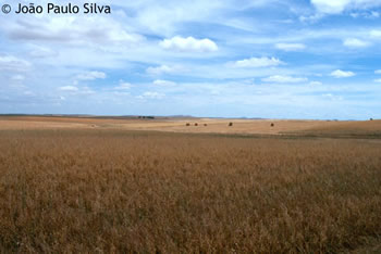
Plains of Castro Verde:


Event of 6 november 1954
1954 Tornado at Castelo Branco (Portugal)
November 6, 1954 12 h 50
F3
Weather : Storm with hail
Landscape:
Personal visit on the site: Not
Length trajectory: ?
Width trajectory (m): ?
Place (X): Castelo branco Nobody bléssés or killed: 5 dead 20 bléssés 40.000 people with damages
Historical knowledge of the phenomenon in Portugal, the tornado which had the greatest impact during the last century was recorded in Castelo Branco, in 1954. Castelo Branco, on November 6, 1954 with 12h50, lasted 30 seconds. Strange, distant noise. “An enormous black cloud having a strange form approached at a fantastic speed”. “Major Darkness and an astonishing noise” as if “thousands of planes passed”. 5 died, 220 wounded, more than 40.000 people with damages. “The wind arrived by the West”. Cars and trucks are turned and trailed. Chimneys and ceilings of houses are cut down. Metal roofing of the market projected in the airs, as well as an enormous iron cupola (with 8 thick iron supports) of the coreto placed in the ground at its side. The barriers distinct from the hinges are projected. Electric roofs, chimneys, wire are on the ground. Twisted balconies, left shutters and windows, a metalic bar in a balcony, cars inserted as of the walls, “idea of a bombardment”, posts of illumination planted in the ground, the cars which circulated were turned over, enormous trees is to tear off. “Corn Field which superficially gave an impression to have passed in an enormous cylinder”. Left section of the quarter of destroyed Cavalry, two horses died. Fallen walls, people taken, folded iron posts, van in charge projected to 20 m of distance and round, trees of the suburbs appearing in the center of the city, of the identified objects pertaining to the cemetery of Benquerenças (to 9 km) appear close to the Hotel of Tourism. Bag of cork of 120 kg were launched to 500 Mr.
Analyze of Castelo Branco tornado starting from the charts of the digital model geopotential Gfs (GPDM)
The charts of analysis of the model follow watch inter alia the situations between 00 Z and 12 Z. Each cards contain 4 charts of different analyses geopotential :
- Analyze 500 hpa HGT (gpdm) - SLP (hpa)
- Analyze 500 hpa T (°C) - HGT (gpdm)
- Analyze 850 hpa T (°C) - HGT (gpdm)
- Analyze 700 hpa RH (%) - HGT (gpdm)


Recent event
2006 Tornado at angra do heroismo(Portugal)
September 15, 2006 18 h 45
F0
Weather : Storm with hail
Landscape:
Personal visit on the site: Not
Length trajectory: ?
Width trajectory (m): ?
Place (X): angra do heroismo
160 km north of angra do heroismo, north of the central group of the azores in a supercell thunderstorm. this info is based on satelite images showing a line of storms 1 which produced an over shooting top indicating rotation in the storm
2006 Tornado at Peniche (Portugal)
4 April, 2006 17 h 20
F1
Weather : Storm with hail
Landscape:
Personal visit on the site: Not
Length trajectory: ?
Width trajectory (m): ?
Place (X): Peniche
The tornado that hit Peniche this afternoon started in Porto da Areia Sul beach and crossed the city. A centenary tree has fallen, a bus was turned with passengers inside, and several buildings suffered damages mainly in the roof.
Radiosondage of Lisbonne and more information


2006 Tornado at Cercal do Alentejo (Portugal)
25 February , 2006 18 h
F2
Weather: Stormy
Landscape:
Personal visit on the site: Not
Length trajectory: 5 km
Width trajectory (m): ?
Place (X): Cercal do Alentejo
Este tornado esteve associado à passagem de um sistema frontal em fase de oclusão pelas regiões do Sul do Continente. O sistema frontal estava associado a uma depressão pouco cavada e que atravessou o território de oeste para leste.
http://homepage.oniduo.pt/joaquim.carva ... entejo.wmv


2004 Tornado at Albufeira (Portugal)
2 september 2004
F?
Weather: Stormy
Landscape:
Personal visit on the site: Not
Length trajectory: ?
Width trajectory (m): ?
Place (X): Albufeira

2005 Tornado at Messines (Portugal)
september 2005
F?
Weather: Stormy
Landscape:
Personal visit on the site: Not
Length trajectory: ?
Width trajectory (m): ?
Place (X): Messines

2006 Tornado at Lagoa (Portugal)
18 december, 2006
F1
Weather: Stormy
Landscape:
Personal visit on the site: Not
Length trajectory: ?
Width trajectory (m): ?
Place (X): Lagoa
http://www.rtp.pt/index.php?article=263678&visual=16