Believe it or not (this is from the western Pacific for typhoon statistics) that in 1997 (in which there was a strong El Nino), the western Pacific had 34 recorded tropical systems. Out of those 34 tropical systems, around 12 became typhoons, and around 10 became supertyphoons (with sustained winds of 125KT [145MPH] or greater). However, check out THIS statistic... during this year, nine Category Five supertyphoons formed. Out of these 9 Category Five systems, three of them reached sustained winds of 160KT (185MPH) and one of them reached sustained winds of 150KT (180MPH). The rest reached 140KT (160MPH) sustained winds, with one of them reaching 145KT (165MPH) sustained winds. One of the Category Five supertyphoons in this season, Supertyphoon Paka (which reached 160KT [185MPH] sustained winds), hit the island of Guam with sustained winds around 175MPH (150KT). When this occurred, one of the highest gusts recorded on the planet - a wind gust of 236MPH - was recorded. Damage was very heavy.
Even though not all of the typhoons and supertyphoons (including Category Five systems) impacted major land masses, many DID impact the Pacific Islands. Imagine if a season like THIS occurred in the Atlantic Basin. I am NOT even CLOSE to saying this season wasn't bad... I was just sharing an incredible statistic and am reminding that, despite all that has happened, thankfulness is very important. Amazing... nine Category Five supertyphoons in one season. WOW.
Can You Believe This: Incredible WPAC Statistics From 1997!
Moderator: S2k Moderators
Forum rules

The posts in this forum are NOT official forecasts and should not be used as such. They are just the opinion of the poster and may or may not be backed by sound meteorological data. They are NOT endorsed by any professional institution or STORM2K. For official information, please refer to products from the National Hurricane Center and National Weather Service.
-
bombarderoazul
- Tropical Storm

- Posts: 186
- Joined: Tue Sep 20, 2005 4:12 pm
-
MiamiensisWx


-
Hurricanehink

- S2K Supporter

- Posts: 2047
- Joined: Sun Nov 16, 2003 2:05 pm
- Location: New Jersey

-
MiamiensisWx
What the western Pacific has to deal with, especially in strong El Nino years like 1997, is really JUST INCREDIBLE. In addition to major land masses being impacted (e.g., the Philippines, Taiwan, China, the Japanese archipelago and islands), you also have to count the numerous other small islands that are impacted by storms that do not even make landfall in much larger land masses. Examples are Kiribati, the Marianas, and the Marshall Islands. In addition, the southern Japanese islands (such as Okinawa and the Bonin Islands) are vulnerable.
0 likes
-
Aslkahuna

- Professional-Met

- Posts: 4550
- Joined: Thu Feb 06, 2003 5:00 pm
- Location: Tucson, AZ
- Contact:
The pressure for Keith is estimated as their is no recon in WPAC so we can't know for sure if it was really 872 mb or higher or lower. Paka did NOT bring a gust to 236 mph on Guam as that report was discounted based upon the observed sustained winds along with the wind reports from other locations on the island. The sensor is the hot wire anemometer which has proven notorious for extraneous high readings during high wind/heavy rain events. I have the JTWC special report on STY Paka and JTWC did NOT find sustained Cat 5 winds on the island and based on their data and analysis the storm would be classified as a Cat 4 hit on the island. BTW, Paka was NOT a WPAC storm but rather originated in CENPAC hence the Hawaiian name. STY Oliwa was also a CENPAC storm that entered WPAC. During the onset El Niño years, the number of STYs is higher than normal while the total number of storms tends to be low during post Niño years. As a Niño season progresses, the area of formation tends to shift eastward thus allowing for long tracked intense storms and a greater threat to Japan. There was also an active season in 1964 in WPAC.
Steve
Steve
Steve
Steve
Last edited by Aslkahuna on Tue Nov 22, 2005 9:08 pm, edited 1 time in total.
0 likes
-
MiamiensisWx
wxmann_91 wrote:Not surprising. The WPAC was unusually quiet this year.
Agreed. The records during El Nino years in the western Pacific are not surprising. However, they are still incredible - just like the 2005 Atlantic Hurricane Season.
Yep... the western Pacific has definately been much more quiet this year and in the past few years.
0 likes
-
MiamiensisWx
Aslkahuna wrote:The pressure for Keith is estimated as their is no recon in WPAC so we can't know for sure if it was really 872 mb or higher or lower. Paka did NOT bring a gust to 236 mph on Guam as that report was discounted based upon the observed sustained winds along with the wind reports from other locations on the island. The sensor is the hot wire anemometer which has proven notorious for extraneous high readings during high wind/heavy rain events. I have the JTWC special report on STY Paka and JTWC did NOT find sustained Cat 5 winds on the island and based on their data and analysis the storm would be classified as a Cat 4 hit on the island. BTW, Paka was NOT a WPAC storm but rather originated in CENPAC hence the Hawaiian name. STY Oliwa was also a CENPAC storm that entered WPAC.
Steve
Oh... thanks for giving the correct information. Also, I know that Paka originated more towards the west-central or central Pacific... what I meant was that Paka passed THROUGH the western Pacific.
0 likes
-
MiamiensisWx
-
HalloweenGale

- Category 1

- Posts: 377
- Joined: Sun Aug 01, 2004 7:31 pm
- Location: Nantucket Ma
- Contact:

-
MiamiensisWx
-
Aslkahuna
- Professional-Met
- Posts: 4550
- Joined: Thu Feb 06, 2003 5:00 pm
- Location: Tucson, AZ
- Contact:
At least one WPAC STY (Gay, 1992) has been traced as the source of a strong Easter US Nor'easter as well (the big December 1992 Nor'easter to be exaCT). Checking the ATCR for 1997 I find that the strongest recorded winds on Guam were 100G149 kt (115G171mph) before the sensor failed. Based upon that, JTWC called the maximum gusts that occurred as 160 kt (184 mph) and that Paka was a Cat 4 130kt STY when the eye went over (150mph) placing it just below STY Karen in 1962 which was a 135kt (155mph) maximum Cat 4 almost Cat 5 hit.
Steve
Steve
0 likes


-
wxmann_91

- Category 5

- Posts: 8013
- Age: 34
- Joined: Fri Jul 15, 2005 2:49 pm
- Location: Southern California
- Contact:
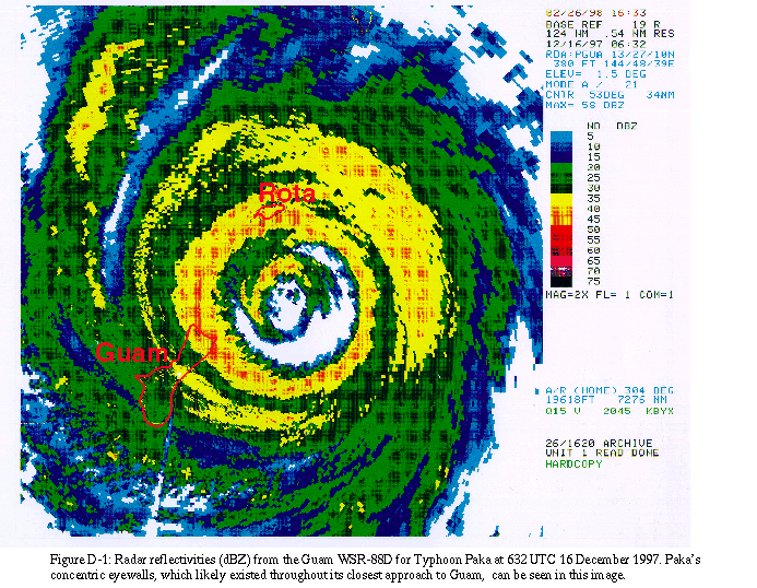
Radar image from Guam showing the ERC Paka was going through at the time.
EDIT: Good website on the winds of Paka. http://www.aoml.noaa.gov/hrd/project98/sh_proj1.html
0 likes
Who is online
Users browsing this forum: No registered users and 116 guests