Storm2k 11am CDT, Tropical outlook
Moderator: S2k Moderators
Forum rules

The posts in this forum are NOT official forecasts and should not be used as such. They are just the opinion of the poster and may or may not be backed by sound meteorological data. They are NOT endorsed by any professional institution or STORM2K. For official information, please refer to products from the National Hurricane Center and National Weather Service.
-
vbhoutex

- Storm2k Executive

- Posts: 29150
- Age: 74
- Joined: Wed Oct 09, 2002 11:31 pm
- Location: Cypress, TX
- Contact:
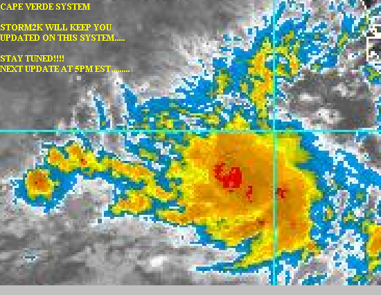
This wave is definitely impressive looking at this time.
Some rotation is noted and with winds from the N in the Cape Verde Islands per Cycloneye's post there is some indication of some type of a low pressure area in the formative stages. There is even a little hint of an outflow pattern trying to develop on the S side of the system.
Shear to the immediate west of the system is in the 10-20 kt. range while there is some destructive 50 kt shear not too far to it's NW. Current progs do not call for much change in the shear situation at this time so we could probably call it marginally ok for development.
As OHD says it is in a very dry environment ATT and does not have a lot of moisture sources to pull from, but I'm not sure how much this might affect the system ATT. We will watch to see if this situation becomes more positive as it appears there may be some moisture approaching from the W, but it is several days off so it might not be of help here.
The cloud tops are beginning to warm which may signal some waning of the system or it could be because the heat of the day is gone in that area.
Overall, the system bears watching at this time, but I sure am not going to hold my breath waiting for it to explode into a TD yet! Overall, ATT, I'd say about 20% chance of further development. If it persists in it's current state, it may have a better chance down the road.
As always, comments and other analysis is welcome and requested.
0 likes
Skywarn, C.E.R.T.
Please click below to donate to STORM2K to help with the expenses of keeping the site going:

Please click below to donate to STORM2K to help with the expenses of keeping the site going:
-
wx247

- S2K Supporter

- Posts: 14279
- Age: 42
- Joined: Wed Feb 05, 2003 10:35 pm
- Location: Monett, Missouri
- Contact:
How far away is the strong shear?
0 likes
Personal Forecast Disclaimer:
The posts in this forum are NOT official forecast and should not be used as such. They are just the opinion of the poster and may or may not be backed by sound meteorological data. They are NOT endorsed by any professional institution or storm2k.org. For official information, please refer to the NHC and NWS products.
The posts in this forum are NOT official forecast and should not be used as such. They are just the opinion of the poster and may or may not be backed by sound meteorological data. They are NOT endorsed by any professional institution or storm2k.org. For official information, please refer to the NHC and NWS products.


Who is online
Users browsing this forum: cainjamin and 276 guests