Invest 96L East of Windwards,Sat Pics,Analysis and Models

This is the general tropical discussion area. Anyone can take their shot at predicting a storms path.

Moderator: S2k Moderators

Forum rules

The posts in this forum are NOT official forecasts and should not be used as such. They are just the opinion of the poster and may or may not be backed by sound meteorological data. They are NOT endorsed by any professional institution or STORM2K. For official information, please refer to products from the National Hurricane Center and National Weather Service.

Help Support Storm2K
Message
Author
User avatar
hurricanefloyd5
Category 5
Category 5
Posts: 1659
Age: 44
Joined: Sun May 02, 2004 10:53 am
Location: Spartanburg
Contact:

Re: Invest 96L East of Windwards,Sat Pics,Analysis and Models

#481 Postby hurricanefloyd5 » Tue Jul 03, 2007 11:42 pm

Aric Dunn wrote:
Tampa Bay Hurricane wrote:well I still think it might have been a
depression or minimal tropical storm
earlier this afternoon
I don't understand how it wasnt
Someone please explain
thank you


to put it simply ... its up to the NHC...


well said aric!!!!!!!!!!!! :D :D :D :D
0 likes   

User avatar
Tampa Bay Hurricane
Category 5
Category 5
Posts: 5597
Age: 37
Joined: Fri Jul 22, 2005 7:54 pm
Location: St. Petersburg, FL

Re: Invest 96L East of Windwards,Sat Pics,Analysis and Models

#482 Postby Tampa Bay Hurricane » Tue Jul 03, 2007 11:44 pm

hurricanefloyd5 wrote:
Aric Dunn wrote:
Tampa Bay Hurricane wrote:well I still think it might have been a
depression or minimal tropical storm
earlier this afternoon
I don't understand how it wasnt
Someone please explain
thank you


to put it simply ... its up to the NHC...


well said aric!!!!!!!!!!!! :D :D :D :D

Too obvious.

Yes I know that...obviously its up to NHC
but I seek the meteorological reason behind this
0 likes   

User avatar
NDG
S2K Supporter
S2K Supporter
Posts: 15455
Joined: Sun Jul 09, 2006 10:14 pm
Location: Orlando, FL

Re: Invest 96L East of Windwards,Sat Pics,Analysis and Models

#483 Postby NDG » Tue Jul 03, 2007 11:45 pm

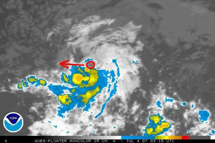
I can clearly see the center of the low not higher than 10.5N and at 41.3W
Image
0 likes   

Aric Dunn
Category 5
Category 5
Posts: 21238
Age: 42
Joined: Sun Sep 19, 2004 9:58 pm
Location: Ready for the Chase.
Contact:

Re: Invest 96L East of Windwards,Sat Pics,Analysis and Models

#484 Postby Aric Dunn » Tue Jul 03, 2007 11:48 pm

NDG wrote:I can clearly see the center of the low not higher than 10.5N and at 41.3W
Image


yep it covers the area from 10.3 to 10.5 ... and i saw the more west motion earlier but decided to not say anything till i saw it continue.. which it has..
0 likes   

User avatar
Tampa Bay Hurricane
Category 5
Category 5
Posts: 5597
Age: 37
Joined: Fri Jul 22, 2005 7:54 pm
Location: St. Petersburg, FL

Re: Invest 96L East of Windwards,Sat Pics,Analysis and Models

#485 Postby Tampa Bay Hurricane » Tue Jul 03, 2007 11:49 pm

I smell a tropical depression. How come it isn't
a tropical depression...obviously the NHC has reasons.
0 likes   


Return to “Talkin' Tropics”

Who is online

Users browsing this forum: Jonny, Kludge, redingtonbeach and 39 guests