Observations in the eastern Pacific

This is the general tropical discussion area. Anyone can take their shot at predicting a storms path.

Moderator: S2k Moderators

Forum rules

The posts in this forum are NOT official forecasts and should not be used as such. They are just the opinion of the poster and may or may not be backed by sound meteorological data. They are NOT endorsed by any professional institution or STORM2K. For official information, please refer to products from the National Hurricane Center and National Weather Service.

Help Support Storm2K
Message
Author
User avatar
Cyclenall
Category 5
Category 5
Posts: 6667
Joined: Thu Jun 08, 2006 10:01 pm
Location: Ontario, Canada

Re: Observations in the eastern Pacific

#21 Postby Cyclenall » Fri Jul 06, 2007 2:57 pm

000
ABPZ20 KNHC 061623
TWOEP
TROPICAL WEATHER OUTLOOK
NWS TPC/NATIONAL HURRICANE CENTER MIAMI FL
1000 AM PDT FRI JUL 6 2007

FOR THE EASTERN NORTH PACIFIC...EAST OF 140 DEGREES WEST LONGITUDE..

AN AREA OF DISTURBED WEATHER HAS DEVELOPED ABOUT 725 MILES SOUTH OF
MANZANILLO MEXICO. CONDITIONS ARE FAVORABLE FOR SOME SLOW
DEVELOPMENT DURING THE NEXT COUPLE OF DAYS.

A SECOND AREA OF DISTURBED WEATHER HAS FORMED ABOUT 1250 MILES
SOUTHWEST OF THE SOUTHERN TIP OF BAJA CALIFORNIA. CONDITIONS HERE
ARE ALSO FAVORABLE FOR SLOW DEVELOPMENT.

ELSEWHERE...TROPICAL CYCLONE FORMATION IS NOT EXPECTED DURING THE
NEXT 48 HOURS.

$$
FORECASTER BROWN


Finally, things are going to happen after a long break. I love how both are said to be in favorable enviroments :D .
0 likes   

User avatar
Aquawind
Category 5
Category 5
Posts: 6714
Age: 62
Joined: Mon Jun 16, 2003 10:41 pm
Location: Salisbury, NC
Contact:

#22 Postby Aquawind » Fri Jul 06, 2007 3:56 pm

Both systems look like they have some work to do. There is alot of convection but little consolidation and they look like they are within the ITCZ yet..
0 likes   

User avatar
Cyclenall
Category 5
Category 5
Posts: 6667
Joined: Thu Jun 08, 2006 10:01 pm
Location: Ontario, Canada

Re: Observations in the eastern Pacific

#23 Postby Cyclenall » Sun Jul 08, 2007 1:20 pm

000
ABPZ20 KNHC 081611
TWOEP
TROPICAL WEATHER OUTLOOK
NWS TPC/NATIONAL HURRICANE CENTER MIAMI FL
1000 AM PDT SUN JUL 8 2007

FOR THE EASTERN NORTH PACIFIC...EAST OF 140 DEGREES WEST LONGITUDE..

A LARGE AREA OF DISTURBED WEATHER ASSOCIATED WITH AN AREA OF LOW
PRESSURE IS CENTERED ABOUT 800 MILES SOUTH-SOUTHWEST OF THE
SOUTHERN TIP OF BAJA CALIFORNIA. THIS SYSTEM CONTINUES TO SHOW SOME
EVIDENCE OF ORGANIZATION...AND IT HAS THE POTENTIAL TO BECOME A
TROPICAL DEPRESSION LATER TODAY OR TONIGHT AS IT MOVES TOWARD THE
WEST OR WEST-NORTHWEST AT 10 TO 15 MPH.

A SMALLER AREA OF DISTURBED WEATHER IS LOCATED ABOUT 1500 MILES
EAST-SOUTHEAST OF THE HAWAIIAN ISLANDS. THIS SYSTEM HAS SOME
POTENTIAL FOR DEVELOPMENT OVER THE NEXT DAY OR TWO AS IT MOVES
GENERALLY WESTWARD AROUND 15 MPH.

ELSEWHERE...TROPICAL CYCLONE FORMATION IS NOT EXPECTED DURING THE
NEXT 48 HOURS.

$$
FORECASTER PASCH

Two systems back on the table. 95E made a comeback this morning and we are back to "potential for development" stage.

One model, the CMC, is showing another TC form in a few days coming off from Panama. The GFS was picking up on it yesterday however is no longer showing something.

Wind shear reminds light in most areas of the Epac and Gulf of Mexico. It is increasing slightly where 94E is but I strongly doubt it will mean much.
0 likes   

User avatar
Cyclenall
Category 5
Category 5
Posts: 6667
Joined: Thu Jun 08, 2006 10:01 pm
Location: Ontario, Canada

#24 Postby Cyclenall » Mon Jul 09, 2007 7:36 pm

Here are my observations in the Epac as of 2 hours ago:

Image

I notice there is strong convection at 105W. Could this be another area to watch?
0 likes   

User avatar
Cyclenall
Category 5
Category 5
Posts: 6667
Joined: Thu Jun 08, 2006 10:01 pm
Location: Ontario, Canada

Re: Observations in the eastern Pacific

#25 Postby Cyclenall » Mon Jul 09, 2007 9:36 pm

Take a look at this: Link

This is the GFDL model run for TD4-E (it's named Invest 04-E for some reason) but that's not the point here. If you look elsewhere, you will find a hurricane system brewing out of the area where the convection I was talking about on my last post. Hopefully that will occur :sled: .
0 likes   

User avatar
Cyclenall
Category 5
Category 5
Posts: 6667
Joined: Thu Jun 08, 2006 10:01 pm
Location: Ontario, Canada

Re: Observations in the eastern Pacific

#26 Postby Cyclenall » Wed Jul 11, 2007 2:53 am

000
ABPZ20 KNHC 110337
TWOEP
TROPICAL WEATHER OUTLOOK
NWS TPC/NATIONAL HURRICANE CENTER MIAMI FL
1000 PM PDT TUE JUL 10 2007

FOR THE EASTERN NORTH PACIFIC...EAST OF 140 DEGREES WEST LONGITUDE..

THE NATIONAL HURRICANE CENTER HAS ISSUED ITS LAST ADVISORY ON
DISSIPATING TROPICAL DEPRESSION FOUR-E...LOCATED ABOUT 850 MILES
WEST-SOUTHWEST OF THE SOUTHERN TIP OF BAJA CALIFORNIA.

A LARGE BUT DISORGANIZED AREA OF DISTURBED WEATHER IS LOCATED
ROUGHLY 800 MILES SOUTH OF THE SOUTHERN TIP OF BAJA CALIFORNIA.
DEVELOPMENT OF THIS SYSTEM...IF ANY...IS EXPECTED TO BE SLOW TO
OCCUR AT IT MOVES WESTWARD AT ABOUT 15 MPH.


ELSEWHERE...TROPICAL CYCLONE FORMATION IS NOT EXPECTED DURING THE
NEXT 48 HOURS.

$$
FORECASTER BROWN/KNABB

The area of convection I was looking at for a few day(s) is now being talked about by the NHC.
0 likes   

User avatar
Cyclenall
Category 5
Category 5
Posts: 6667
Joined: Thu Jun 08, 2006 10:01 pm
Location: Ontario, Canada

Re: Observations in the eastern Pacific

#27 Postby Cyclenall » Wed Jul 11, 2007 1:48 pm

000
ABPZ20 KNHC 111639
TWOEP
TROPICAL WEATHER OUTLOOK
NWS TPC/NATIONAL HURRICANE CENTER MIAMI FL
1000 AM PDT WED JUL 11 2007

FOR THE EASTERN NORTH PACIFIC...EAST OF 140 DEGREES WEST LONGITUDE..

A REMNANT LOW ASSOCIATED WITH FORMER TROPICAL DEPRESSION FOUR-E IS
LOCATED ABOUT 975 MILES WEST-SOUTHWEST OF THE SOUTHERN TIP OF BAJA
CALIFORNIA...MOVING WESTWARD AT ABOUT 10 MPH. REGENERATION IS NOT
ANTICIPATED.

A LARGE BUT DISORGANIZED AREA OF DISTURBED WEATHER CENTERED ABOUT
825 MILES SOUTH-SOUTHWEST OF THE SOUTHERN TIP OF BAJA CALIFORNIA IS
MOVING WESTWARD AT 15 MPH. DEVELOPMENT...IF ANY...WILL BE SLOW TO
OCCUR.


ANOTHER AREA OF DISTURBED WEATHER HAS FORMED ABOUT 350 MILES SOUTH
OF ACAPULCO MEXICO. THIS SYSTEM HAS SOME POTENTIAL FOR DEVELOPMENT
AS IT MOVES WESTWARD DURING THE NEXT DAY OR TWO.


ELSEWHERE...TROPICAL CYCLONE FORMATION IS NOT EXPECTED DURING THE
NEXT 48 HOURS.

$$
FORECASTER AVILA

Now another area to watch.
0 likes   

User avatar
Cyclenall
Category 5
Category 5
Posts: 6667
Joined: Thu Jun 08, 2006 10:01 pm
Location: Ontario, Canada

Re: Observations in the eastern Pacific

#28 Postby Cyclenall » Wed Jul 11, 2007 11:23 pm

Here is the current genesis probability:

Image

A 10-12% chance of TC formation in the are I'm watching with the NHC.
0 likes   

User avatar
Cyclenall
Category 5
Category 5
Posts: 6667
Joined: Thu Jun 08, 2006 10:01 pm
Location: Ontario, Canada

Re: Observations in the eastern Pacific

#29 Postby Cyclenall » Thu Jul 12, 2007 1:45 pm

Update: There is model consistency of that area the NHC isn't talking about now that is further west then the other area that they are watching for formation later on. The CMC, GFS, Ukmet, and NGP models all show a tropical cyclone forming out of it. The CMC model is showing 3 tropical cyclones almost all at the same time forming!
0 likes   

User avatar
Cyclenall
Category 5
Category 5
Posts: 6667
Joined: Thu Jun 08, 2006 10:01 pm
Location: Ontario, Canada

Re: Observations in the eastern Pacific

#30 Postby Cyclenall » Thu Jul 12, 2007 11:31 pm

Cyclenall wrote:Update: There is model consistency of that area the NHC isn't talking about now that is further west then the other area that they are watching for formation later on. The CMC, GFS, Ukmet, and NGP models all show a tropical cyclone forming out of it. The CMC model is showing 3 tropical cyclones almost all at the same time forming!

The area of convection in which the models are predicting TC formation is being talked about again by the NHC:

000
ABPZ20 KNHC 130344
TWOEP
TROPICAL WEATHER OUTLOOK
NWS TPC/NATIONAL HURRICANE CENTER MIAMI FL
1000 PM PDT THU JUL 12 2007

FOR THE EASTERN NORTH PACIFIC...EAST OF 140 DEGREES WEST LONGITUDE..

SHOWERS AND THUNDERSTORMS WITH THE AREA OF DISTURBED WEATHER
CENTERED ABOUT 500 MILES SOUTH-SOUTHWEST OF MANZANILLO MEXICO HAVE
NOT BECOME ANY BETTER ORGANIZED THIS EVENING. HOWEVER...THIS
SYSTEM HAS THE POTENTIAL FOR DEVELOPMENT OVER THE NEXT DAY OR TWO
AS IT MOVES TO THE WEST OR WEST-NORTHWEST.

A LARGE AREA OF DISTURBED WEATHER IS CENTERED ABOUT 1100 MILES
SOUTHWEST OF THE SOUTHERN TIP OF BAJA CALIFORNIA. SLOW DEVELOPMENT
OF THIS SYSTEM IS POSSIBLE OVER THE NEXT COUPLE OF DAYS.


ELSEWHERE...TROPICAL CYCLONE FORMATION IS NOT EXPECTED DURING THE
NEXT 48 HOURS.

$$
FORECASTER FRANKLIN

It's been a very long time without a TS in the Epac and it's 2006 all over again. I think now it's longer without a named storm then last year :x .
0 likes   

User avatar
Cyclenall
Category 5
Category 5
Posts: 6667
Joined: Thu Jun 08, 2006 10:01 pm
Location: Ontario, Canada

Re: Observations in the eastern Pacific

#31 Postby Cyclenall » Mon Jul 16, 2007 6:12 pm

The area I was watching ended up becoming the first hurricane of the Epac and the western Hemisphere for 2007. Here is the latest TWO from the NHC:

000
ABPZ20 KNHC 162233
TWOEP
TROPICAL WEATHER OUTLOOK...CORRECTED
NWS TPC/NATIONAL HURRICANE CENTER MIAMI FL
400 PM PDT MON JUL 16 2007

...CORRECTED TO UPGRADE COSME TO A HURRICANE...

FOR THE EASTERN NORTH PACIFIC...EAST OF 140 DEGREES WEST LONGITUDE..

THE NATIONAL HURRICANE CENTER IS ISSUING ADVISORIES ON
RECENTLY-UPGRADED HURRICANE COSME...LOCATED ABOUT 1605 MILES EAST
OF HILO HAWAII.

SHOWERS AND THUNDERSTORMS ASSOCIATED WITH A TROPICAL WAVE EXTEND
FROM THE MEXICAN COAST ALONG THE GULF OF TEHUANTEPEC SOUTHWESTWARD
FOR SEVERAL HUNDRED MILES. ANY DEVELOPMENT OF THIS SYSTEM SHOULD BE
SLOW TO OCCUR.
HOWEVER...THIS SYSTEM COULD PRODUCE HEAVY RAINS
OVER PORTIONS OF COASTAL MEXICO FROM ACAPULCO EASTWARD DURING THE
NEXT DAY OR SO.

ELSEWHERE...TROPICAL CYCLONE FORMATION IS NOT EXPECTED DURING THE
NEXT 48 HOURS.

$$
FORECASTER BEVEN

We briefly had TD5-E and that was a weak system that did nothing. Then Hurricane Cosme, now possibility another system near Mexico. IMO, this has been a strange season so far for the Atlantic, Epac, and Wpac basins. It's been quiet for all 3 before now (early July/late June) which usually isn't the case.
0 likes   

User avatar
Andrew92
S2K Supporter
S2K Supporter
Posts: 3247
Age: 41
Joined: Mon Jun 16, 2003 12:35 am
Location: Phoenix, Arizona

#32 Postby Andrew92 » Mon Jul 16, 2007 6:16 pm

I'm noticing a little trend in the EPAC season so far. Maybe it's a little early to be noticing trends, but I'll mention it anyway.

Every tropical storm in the EPAC so far has formed south of 15 degrees. The three depressions that failed to become storms all formed north of 15 degrees. Is this due to cooler EPAC waters that are in place due to neutral to borderline La Nina conditions? Is the air very stable out there? Is there a lot of shear? Is it something else? Or is it a combination of some or all of these factors?

I think the EPAC is going to be pretty quiet this year. 12 or 13 storms, 6 or 7 hurricanes.

-Andrew92
0 likes   

User avatar
HURAKAN
Professional-Met
Professional-Met
Posts: 46086
Age: 38
Joined: Thu May 20, 2004 4:34 pm
Location: Key West, FL
Contact:

#33 Postby HURAKAN » Mon Jul 16, 2007 6:24 pm

Between 5/15 - 7/16

2000:
1 Hurricane ALETTA 22-28 MAY 90 2
2 Tropical Storm BUD 13-17 JUN 45 -
3 Hurricane CARLOTTA 18-25 JUN 130 4
4 Tropical Depression FOUR_E 06-07 JUL 30 1007

2001:
1 Hurricane ADOLPH 25 MAY-02 JUN 125 4
2 Tropical Storm BARBARA 20-22 JUN 50 -
3 Tropical Storm COSME 13-15 JUL 45 -

2002:
1 Hurricane ALMA 24 MAY-01 JUN 95 2
2 Tropical Storm BORIS 08-11 JUN 50 -
3 Tropical Depression THREE_ 27-29 JUN 30 1007 -
4 Tropical Storm CRISTINA 09-16 JUL 55 -

2003:
1 Tropical Storm ANDRES 20-26 MAY 40 -
2 Tropical Storm BLANCA 17-22 JUN 55 -
3 Tropical Storm CARLOS 26-27 JUN 55 -
4 Tropical Storm DOLORES 06-08 JUL 35 -
5 Tropical Storm ENRIQUE 10-16 JUL 55 993 -

2004:
1 Tropical Storm AGATHA 22-25 MAY 45 -
2 Tropical Depression TWO_E 02-03 JUL 25 1007 -
3 Tropical Storm BLAS 12-15 JUL 50 -


2005:
1 Hurricane ADRIAN 17-20 MAY 75 982 1
2 Tropical Storm BEATRIZ 21-24 JUN 45 1000 -
3 Tropical Storm CALVIN 26-29 JUN 45 1000 -
4 Tropical Storm DORA 04-06 JUL 35 1006 -

2006:
1 Tropical Storm ALETTA 27-31 MAY 40 1002 -
2 Hurricane BUD 11-17 JUL 110 953 3
3 Hurricane CARLOTTA 12-20 JUL 75 981 1
4 Hurricane DANIEL 16-28 JUL 130 933 4

2007:
1 Tropical Storm ALVIN 27-31 MAY 35 -
2 Tropical Storm BARBARA 29 MAY-02 JUN 45 -
3 Tropical Depression THREE_ 11-13 JUN 30 1004 -
4 Tropical Depression FOUR_E 09-11 JUL 30 1006 -
5 Tropical Storm FIVE_E 15-16 JUL 35 -
6 Hurricane COSME 14-16 JUL 65 1

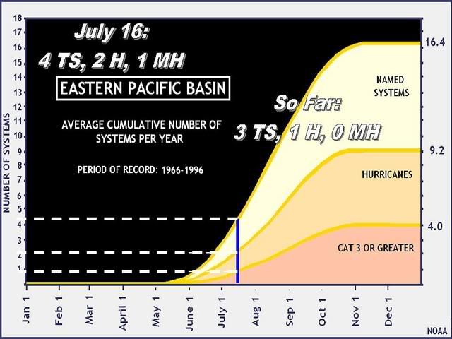
The only unusual so far about the 2007 season for the EPAC was the drought of a name system between Bárbara and Cosme. Nonetheless, it's in schedule compared to past seasons.

I don't like to use averages or to look to averages because we never get an average season. It's usually a balance between high seasons and low seasons, average seasons are rare.
0 likes   

User avatar
Andrew92
S2K Supporter
S2K Supporter
Posts: 3247
Age: 41
Joined: Mon Jun 16, 2003 12:35 am
Location: Phoenix, Arizona

#34 Postby Andrew92 » Mon Jul 16, 2007 6:39 pm

Yeah, I know it might be a little early to be looking at trends since it is only July 16. And I am one who usually tells people to be patient when they look for activity this early in the Atlantic. But only two years since 2000 have not seen a hurricane by this time in the EPAC, and both of those seasons were either average or below average (although one of them, 2003, did produce two landfalling hurricanes in Ignacio and Marty). There usually is at least one, sometimes two, hurricanes by this time in the EPAC.

And if the storms, so far anyway, have to form this far south when just about every other year has been able to sustain even a little tropical storm activity north of 15 degrees (even if just barely), it just seems to me that the EPAC is going to be quiet this year.

We'll have to wait and see, though.

-Andrew92
0 likes   

User avatar
HURAKAN
Professional-Met
Professional-Met
Posts: 46086
Age: 38
Joined: Thu May 20, 2004 4:34 pm
Location: Key West, FL
Contact:

Re: Observations in the eastern Pacific

#35 Postby HURAKAN » Mon Jul 16, 2007 7:14 pm

Image
0 likes   


Return to “Talkin' Tropics”

Who is online

Users browsing this forum: redingtonbeach and 39 guests