Wave Coming Behind 94L
Moderator: S2k Moderators
Forum rules

The posts in this forum are NOT official forecasts and should not be used as such. They are just the opinion of the poster and may or may not be backed by sound meteorological data. They are NOT endorsed by any professional institution or STORM2K. For official information, please refer to products from the National Hurricane Center and National Weather Service.


-
Matt-hurricanewatcher
Re: Wave Coming Behind 94L
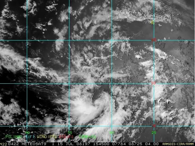
This area is much more favorable then 94L. I think its time to switch to watching this, let 94L die.
0 likes
-
Extremeweatherguy

- Category 5

- Posts: 11095
- Joined: Mon Oct 10, 2005 8:13 pm
- Location: Florida


-
Squarethecircle
- Category 5
- Posts: 2165
- Joined: Fri Oct 19, 2007 4:00 pm
- Location: Fairfax, VA


-
Ed Mahmoud
Re: Wave Coming Behind 94L
After looking at convergence, divergence and shear maps EWG posted on Northeast GOMEX thread, and comparing satellite presentation, while the NE GOMEX is far from a lock to develop, it has a better chance than this does.
Yesterday, I thought a tropical storm reaching the mid Lesser Antilles, a path W-NW through the Caribbean to a point somewhere South of Cuba, and a turn Northwest across Cuba, coming out either side of Florida or maybe over South Florida, and a threat anywhere (depending on where it crossed Cuba) from near Mobile to Hatteras.
Now, I strongly suspect an open wave that crosses the Caribbean, hits Central America, and maybe pops in the Pacific, although the MJO phase isn't super-favorable.
The wave behind 94L also has a better chance to develop, based on presentation, shear, low level convergence, upper divergence and water vapor imagery.
The Northeast Gulf system could wind up an invest, maybe even a TD or weak storm, but I suspect it'll be more a beneficial rain maker than a threat. Too soon to tell about wave near 30ºW
Disclaimer: Unofficial, amateur, and not endorsed by Storm2K or the American Dental Association.
0 likes


Yesterday, I thought a tropical storm reaching the mid Lesser Antilles, a path W-NW through the Caribbean to a point somewhere South of Cuba, and a turn Northwest across Cuba, coming out either side of Florida or maybe over South Florida, and a threat anywhere (depending on where it crossed Cuba) from near Mobile to Hatteras.
Now, I strongly suspect an open wave that crosses the Caribbean, hits Central America, and maybe pops in the Pacific, although the MJO phase isn't super-favorable
Ed,
Just a quick comment - that's why the old NHC policy of waiting before upgrading a system is a good policy. Yesterday's system could have been easily upgraded to a depression or more than a depression, only to be dowgraded this morning, so, per Dr. Frank's comments (not this Frank - LOL), he has a valid point...
0 likes


Who is online
Users browsing this forum: bird and 57 guests