
Development with Tropical Wave in MDR?
Moderator: S2k Moderators
Forum rules

The posts in this forum are NOT official forecasts and should not be used as such. They are just the opinion of the poster and may or may not be backed by sound meteorological data. They are NOT endorsed by any professional institution or STORM2K. For official information, please refer to products from the National Hurricane Center and National Weather Service.
-
cycloneye

- Admin

- Posts: 148737
- Age: 69
- Joined: Thu Oct 10, 2002 10:54 am
- Location: San Juan, Puerto Rico
Re: Development with Strong Tropical Wave in MDR?
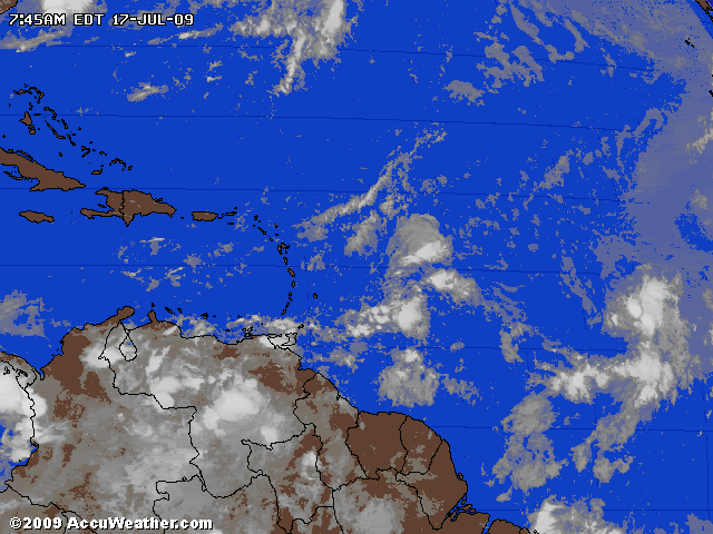
Pic that shows shear mainly north of 15N,wave 1 and wave 2.
0 likes
-
gatorcane

- S2K Supporter

- Posts: 23703
- Age: 47
- Joined: Sun Mar 13, 2005 3:54 pm
- Location: Boca Raton, FL
Here is a snippet from HPC's Caribbean forecast discussion issued 217pm EDT Thu. Jul 16 2009.
The TUTT they mention is what is creating the high shear out ahead of the wave and which should prevent development of this wave. This TUTT feature is very common for July and is part of the reason why the Caribbean is *typically* shut down this month.
But one thing to pay attention to is the possibility this wave flares up as it approaches the shear which may provide some very intense rainfall for the Eastern Caribbean islands as discussed here. Cycloneye has already discusses this rain possiblity.
AT 250 HPA...A TUTT EXTENDS ACROSS THE CENTRAL ATLANTIC TO THE
NORTHEAST CARIBBEAN ISLANDS...THEN WEST ACROSS HISPANIOLA TO
ANOTHER TUTT OVER THE NORTHWEST CARIBBEAN. THE UPPER TROUGH WILL
REMAIN ALONG 20N DURING THE NEXT THREE DAYS...SEPARATING A RIDGE
OVER THE WESTERN ATLANTIC FROM ANOTHER OVER THE TROPICAL ATLANTIC.
AS THE AFOREMENTIONED MID LEVEL RIDGE WEAKENS LATER IN THE
CYCLE...THE TUTT ALOFT WILL PROVIDE THE VENTILATION TO DEEP
CONVECTION ACROSS THE EASTERN CARIBBEAN ISLANDS.
http://www.hpc.ncep.noaa.gov/discussions/fxca20.html
Last edited by gatorcane on Fri Jul 17, 2009 8:39 am, edited 1 time in total.
0 likes
-
StormTracker

- S2K Supporter
- Posts: 2909
- Age: 59
- Joined: Thu Jun 29, 2006 6:06 am
- Location: Quail Heights(Redlands), FL.
Re: Development with Strong Tropical Wave in MDR?
0 likes

Re: Development with Strong Tropical Wave in MDR?
StormTracker wrote::?: Does anybody have a handle on how long that 50-60kt shear has been in place & do we know when it may start decreasing? I doubt we'll see wave #2 flat-line below the shear and develop!
It may start to decrease in 96-120 h most of all in the Caribbean and north of the ITCZ, you could take a look at these loops:
http://www.meteo.psu.edu/~gadomski/COMPSHEARATL_0z/comploop.html
0 likes
-
StormTracker
- S2K Supporter
- Posts: 2909
- Age: 59
- Joined: Thu Jun 29, 2006 6:06 am
- Location: Quail Heights(Redlands), FL.
Re: Development with Strong Tropical Wave in MDR?
Macrocane wrote:StormTracker wrote::?: Does anybody have a handle on how long that 50-60kt shear has been in place & do we know when it may start decreasing? I doubt we'll see wave #2 flat-line below the shear and develop!
It may start to decrease in 96-120 h most of all in the Caribbean and north of the ITCZ, you could take a look at these loops:
http://www.meteo.psu.edu/~gadomski/COMPSHEARATL_0z/comploop.html
I can't get that link to work MC!
0 likes
-
StormTracker
- S2K Supporter
- Posts: 2909
- Age: 59
- Joined: Thu Jun 29, 2006 6:06 am
- Location: Quail Heights(Redlands), FL.
Re: Development with Strong Tropical Wave in MDR?
StormTracker wrote:Macrocane wrote:StormTracker wrote::?: Does anybody have a handle on how long that 50-60kt shear has been in place & do we know when it may start decreasing? I doubt we'll see wave #2 flat-line below the shear and develop!
It may start to decrease in 96-120 h most of all in the Caribbean and north of the ITCZ, you could take a look at these loops:
http://www.meteo.psu.edu/~gadomski/COMPSHEARATL_0z/comploop.html
I can't get that link to work MC!
Working now...thanks!
0 likes
-
AtlanticWind

- S2K Supporter
- Posts: 1898
- Age: 67
- Joined: Sun Aug 08, 2004 9:57 pm
- Location: Plantation,Fla
Re: Development with Strong Tropical Wave in MDR?
Jeff Masters
There's finally a African tropical wave worth mentioning, in what has been a very inactive June/July period for African waves with a potential to develop. A tropical wave near 12N 36W, about 1000 miles west of the coast of Africa, is triggering some modest heavy thunderstorm activity over the open ocean as the storm moves west at 10 - 15 mph. Wind shear is a modest 15 knots over the disturbance, which is low enough to allow some slow development over the next few days. As long as the disturbance stays south of Puerto Rico's latitude (18°N), wind shear should remain low enough to allow development. However, there is a substantial amount of African dust and dry air surrounding the system on its west and north sides. This dry air will retard development, and may be able to completely disrupt the disturbance at some point over the next 3 - 4 days. None of the computer models develop the disturbance. The National Hurricane Center is giving this system a low (less than 30% chance) of developing into a tropical depression in the next 48 hours.
There's finally a African tropical wave worth mentioning, in what has been a very inactive June/July period for African waves with a potential to develop. A tropical wave near 12N 36W, about 1000 miles west of the coast of Africa, is triggering some modest heavy thunderstorm activity over the open ocean as the storm moves west at 10 - 15 mph. Wind shear is a modest 15 knots over the disturbance, which is low enough to allow some slow development over the next few days. As long as the disturbance stays south of Puerto Rico's latitude (18°N), wind shear should remain low enough to allow development. However, there is a substantial amount of African dust and dry air surrounding the system on its west and north sides. This dry air will retard development, and may be able to completely disrupt the disturbance at some point over the next 3 - 4 days. None of the computer models develop the disturbance. The National Hurricane Center is giving this system a low (less than 30% chance) of developing into a tropical depression in the next 48 hours.
0 likes


-
floridasun78
- Category 5

- Posts: 3755
- Joined: Sun May 17, 2009 10:16 pm
- Location: miami fl
Re: Development with Strong Tropical Wave in MDR?
it look like storm are increasing with wave that nhc talking about in last few frame
0 likes
-
cycloneye
- Admin
- Posts: 148737
- Age: 69
- Joined: Thu Oct 10, 2002 10:54 am
- Location: San Juan, Puerto Rico
Re: Development with Strong Tropical Wave in MDR?
Well peeps guess what,we have INVEST!!.Thread is locked and all the discussions about this disturbance are now at Active Storms forum.
Link to invest 97L thread.
viewtopic.php?f=59&t=105863&hilit=&p=1893100#p1893100
Link to invest 97L thread.
viewtopic.php?f=59&t=105863&hilit=&p=1893100#p1893100
0 likes
Who is online
Users browsing this forum: Google [Bot] and 109 guests