
From the 805 AM TWD...
"A tropical wave is over the central tropical Atlantic with axis
analyzed from 11n40w to 3n48w moving W at 8 kt. The wave is
embedded within an area of elevated values of moisture as seen
in the total precipitable water imagery. Low level satellite
derived wind data shows a sharp cyclonic turning along the wave
axis. Scattered moderate and isolated strong convection has
become more pronounced today in the last 6 to 9 hours in
association with the wave from 7n-12n between 40w-50w."
http://forecast.weather.gov/product.php ... ssuedby=AT
Central Atlantic tropical wave
Moderator: S2k Moderators
Forum rules

The posts in this forum are NOT official forecasts and should not be used as such. They are just the opinion of the poster and may or may not be backed by sound meteorological data. They are NOT endorsed by any professional institution or STORM2K. For official information, please refer to products from the National Hurricane Center and National Weather Service.
Central Atlantic tropical wave
0 likes

Re: New wave with potential
Convection is mostly sheared induced MCS.
However, shear has begun to drop
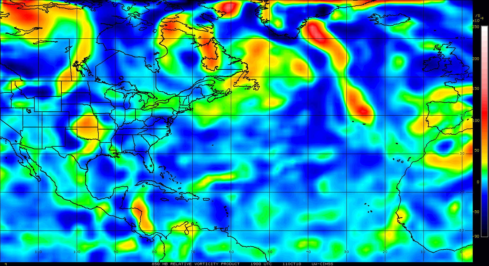
However, good looking 850mb vorticity a bit south of the convection.
Anti-cyclone is centered over the LL vorticity.


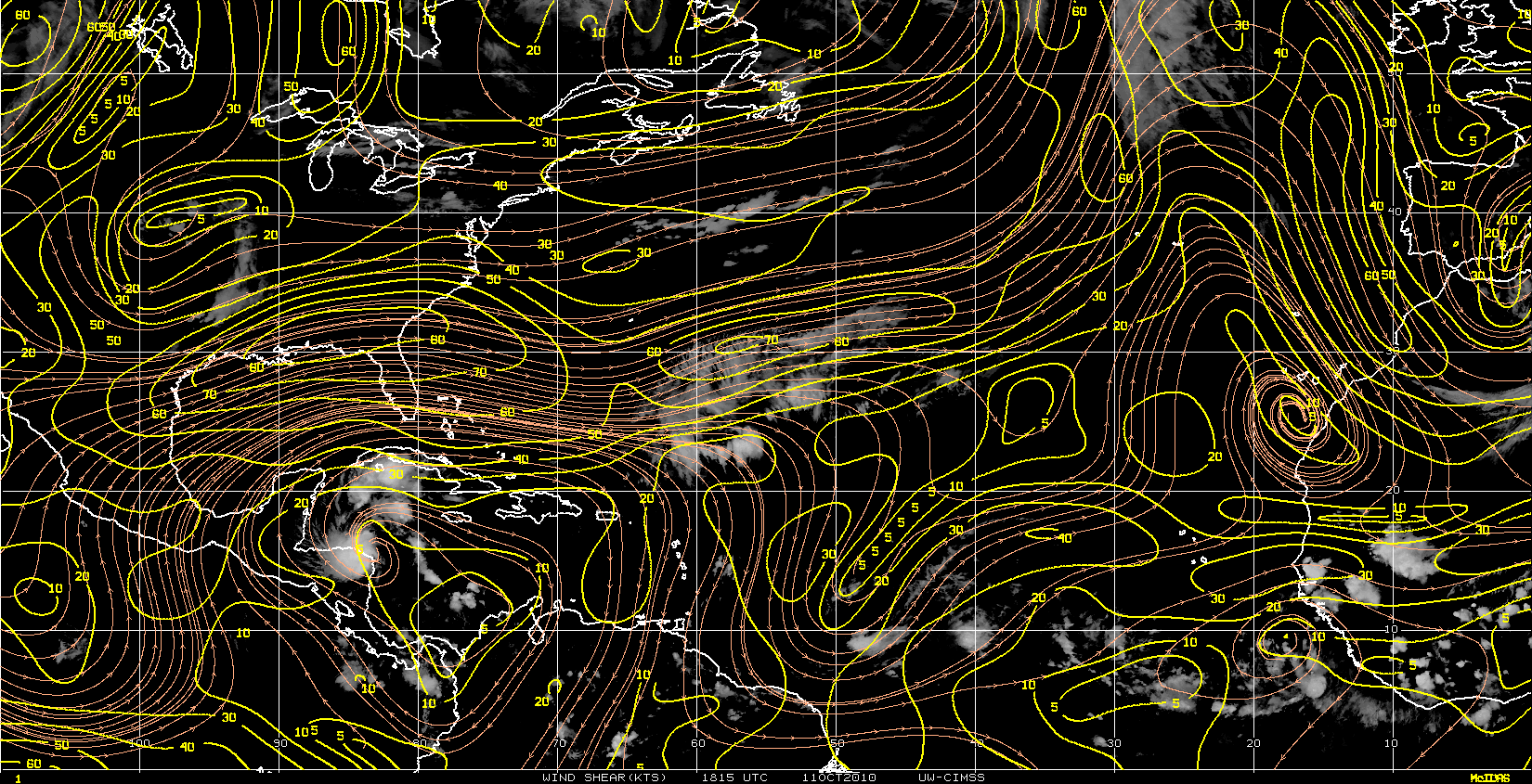
However, shear has begun to drop
However, good looking 850mb vorticity a bit south of the convection.
Anti-cyclone is centered over the LL vorticity.
0 likes
-
Florida1118
Re: New wave with potential
Not bad. Maybe another player in a week or so. If its still there of course.
0 likes
Re: Central Atlantic tropical wave with potential
From the 205 PM TWDAT...
"A tropical wave is over the central tropical Atlantic with axis
from 12n43w to 9n47w 4n50w moving W at 10 kt. The wave is
embedded within an area of elevated values of moisture as seen
in the total precipitable water imagery. Low level satellite
derived wind data shows a sharp cyclonic turning along the wave
axis. Scattered moderate to isolated strong convection is from
9n-13n between 43w-50w."
http://forecast.weather.gov/product.php ... ssuedby=AT
0 likes
-
chrisjslucia
- S2K Supporter

- Posts: 236
- Joined: Thu Oct 09, 2008 8:27 pm
- Location: St Lucia
Re: Central Atlantic tropical wave with potential
From this mornings NHC Tropical Discussion ...
..TROPICAL WAVES...
TROPICAL WAVE EXTENDS FROM 13N49W TO 6N53W MOVING NW NEAR 15 KT.
WAVE REMAINS EMBEDDED WITHIN AN AREA OF DEEP LAYERED MOISTURE AS
DEPICTED ON THE TOTAL PRECIPITABLE WATER IMAGERY. SCATTERED
MODERATE/STRONG CONVECTION IS FROM 12N-15N BETWEEN 49W-55W WITH
CLUSTERS OF SCATTERED MODERATE/ISOLATED STRONG CONVECTION FROM
12N-15N BETWEEN 45W-48W AND FROM 8N-12N BETWEEN 52W-57W.
This has changed track from West to North West and speeded up somewhat. A further change to North would be helpful but it does look as if the Eastern Caribbean could be set for more rain and on this trajectory those islands already saturated will have more rain to face. Given the trough east of the Windwards / Leewards heading North, Puerto Rico and others may face twin systems within the next few days. Any good news from experts would be welcome!!
Please note this is a non-met persons observation and has no validity as a forecast or warning. Check your local met service or NHC for accurate information
0 likes


Re: Central Atlantic tropical wave with potential
No, it still exists. It’s just very weak:OURAGAN wrote:dissipated

(Then again, this surface analysis is a bit old.)
0 likes
-
Gustywind

- Category 5

- Posts: 12334
- Joined: Mon Sep 03, 2007 7:29 am
- Location: Baie-Mahault, GUADELOUPE
000
AXNT20 KNHC 091156
TWDAT
TROPICAL WEATHER DISCUSSION
NWS TPC/NATIONAL HURRICANE CENTER MIAMI FL
805 AM EDT SAT OCT 09 2010
TROPICAL WEATHER DISCUSSION FOR NORTH AMERICA...CENTRAL
AMERICA...GULF OF MEXICO...CARIBBEAN SEA...NORTHERN SECTIONS OF
SOUTH AMERICA...AND ATLANTIC OCEAN TO THE AFRICAN COAST FROM THE
EQUATOR TO 32N. THE FOLLOWING INFORMATION IS BASED ON SATELLITE
IMAGERY...METEOROLOGICAL ANALYSIS...WEATHER OBSERVATIONS...AND
RADAR.
BASED ON 0600 UTC SURFACE ANALYSIS AND SATELLITE IMAGERY THROUGH
1015 UTC.
...TROPICAL WAVES...
TROPICAL WAVE EXTENDS FROM 15N57W TO 8N60W MOVING NW 15-20 KT.
WAVE REMAINS EMBEDDED WITHIN AN AREA OF DEEP LAYERED MOISTURE AS
DEPICTED ON THE TOTAL PRECIPITABLE WATER IMAGERY. HOWEVER THERE
ARE ONLY SCATTERED SHOWERS AND POSSIBLE ISOLATED THUNDERSTORMS
ARE FROM 13N-18N BETWEEN 52W-58W.
$$
PAW
0 likes
Who is online
Users browsing this forum: NotAHurricane and 72 guests