Developing Low -Heavy Rain/Gale Force Winds- Is invest 93L

This is the general tropical discussion area. Anyone can take their shot at predicting a storms path.

Moderator: S2k Moderators

Forum rules

The posts in this forum are NOT official forecasts and should not be used as such. They are just the opinion of the poster and may or may not be backed by sound meteorological data. They are NOT endorsed by any professional institution or STORM2K. For official information, please refer to products from the National Hurricane Center and National Weather Service.

Help Support Storm2K
Message
Author
User avatar
fci
S2K Supporter
S2K Supporter
Posts: 3324
Joined: Tue Sep 14, 2004 10:29 am
Location: Lake Worth, FL

Re: Developing Low - Heavy Rain/Gale Force Winds-30%

#121 Postby fci » Sun Oct 09, 2011 2:55 am

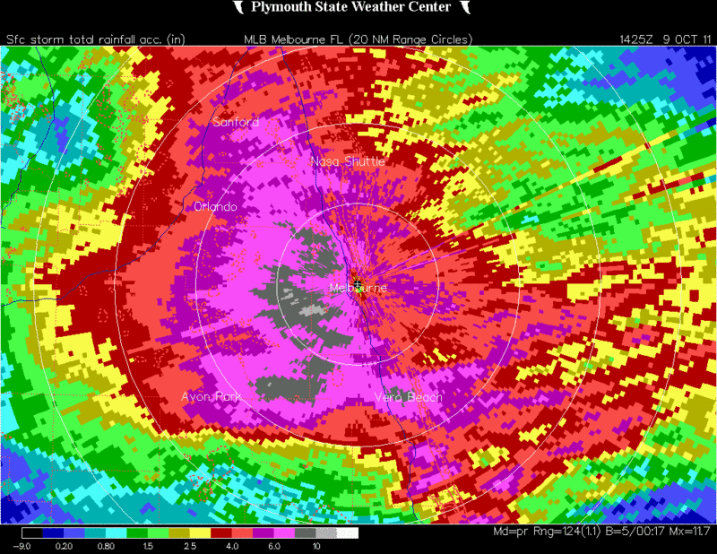
SouthFLTropics wrote:This system is just what the doctor has ordered for us in Florida. Something to give us weather enthusists some excitement and something to replenish the water table. Hopefully some of this that is falling will end up in Lake O.

SFT


As long as it does not flood out Port St Lucie and that area, it is exactly what we like, as you said.
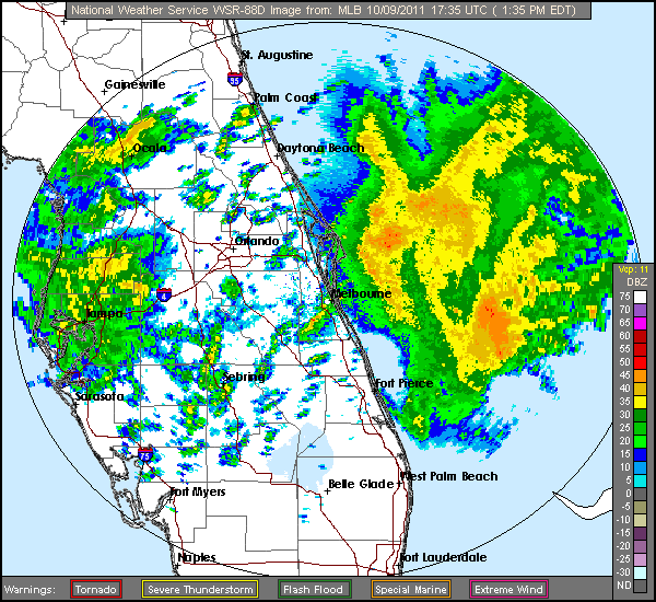
Our area in Palm Beach County seemed to escape much of the rain.
North of here reports of 10 inches
South of here, flood advisories in Dade County but here, not a lot of liquid.
Still is fun for weather enthusiasts and as long as the flooding isn't so bad up north of here, the right kind of system.
0 likes   

User avatar
cycloneye
Admin
Admin
Posts: 145422
Age: 68
Joined: Thu Oct 10, 2002 10:54 am
Location: San Juan, Puerto Rico

Re: Developing Low - Heavy Rain/Gale Force Winds-30%

#122 Postby cycloneye » Sun Oct 09, 2011 6:34 am

TROPICAL WEATHER OUTLOOK
NWS NATIONAL HURRICANE CENTER MIAMI FL
800 AM EDT SUN OCT 9 2011

FOR THE NORTH ATLANTIC...CARIBBEAN SEA AND THE GULF OF MEXICO...

A TROUGH OF LOW PRESSURE EXTENDING FROM THE SOUTHEASTERN GULF OF
MEXICO ACROSS THE FLORIDA STRAITS INTO THE NORTHWESTERN BAHAMAS IS
PRODUCING GALE-FORCE WINDS OVER PORTIONS OF THE WESTERN ATLANTIC...
AND WIDESPREAD CLOUDINESS AND THUNDERSTORMS OVER EASTERN CUBA...
HISPANIOLA...THE BAHAMAS...THE FLORIDA PENINSULA...AND THE ADJACENT
ATLANTIC WATERS. ALTHOUGH SURFACE PRESSURES ARE STILL SLOWLY
FALLING...THERE HAS BEEN LITTLE CHANGE IN THE ORGANIZATION OF THIS
DISTURBANCE IN THE LAST SEVERAL HOURS. HOWEVER...SOME DEVELOPMENT IS
POSSIBLE OVER THE NEXT COUPLE OF DAYS AS IT MOVES NORTHWESTWARD AT
5 TO 10 MPH...AND THIS SYSTEM HAS A MEDIUM CHANCE...30 PERCENT...OF
BECOMING A SUBTROPICAL OR TROPICAL CYCLONE DURING THE NEXT 48
HOURS. REGARDLESS OF DEVELOPMENT...STRONG GUSTY WINDS AND LOCALLY
HEAVY RAINFALL ARE EXPECTED OVER THE NORTHERN BAHAMAS AND PORTIONS
OF THE FLORIDA PENINSULA TODAY. THESE CONDITIONS ARE EXPECTED TO
SPREAD NORTHWARD INTO EASTERN PORTIONS OF GEORGIA AND SOUTH
CAROLINA DURING THE NEXT DAY OR TWO. FOR ADDITIONAL INFORMATION
SPECIFIC TO YOUR AREA...PLEASE SEE STATEMENTS ISSUED BY YOUR LOCAL
WEATHER OFFICE.

ELSEWHERE...TROPICAL CYCLONE FORMATION IS NOT EXPECTED DURING THE
NEXT 48 HOURS.

$$
FORECASTER KIMBERLAIN
0 likes   
Visit the Caribbean-Central America Weather Thread where you can find at first post web cams,radars
and observations from Caribbean basin members Click Here

User avatar
AJC3
Admin
Admin
Posts: 3999
Age: 61
Joined: Tue Aug 31, 2004 7:04 pm
Location: Ballston Spa, New York
Contact:

Re: Developing Low - Heavy Rain/Gale Force Winds-30%

#123 Postby AJC3 » Sun Oct 09, 2011 8:08 am

A broad surface trough axis is along a SW-NE line extending from western Cuba to the western Bahamas. On visible satellite you can see a broad/weak low cloud swirl trying to take shape offshore SE Florida, about mid way between Key Biscayne and West End, Grand Bahama Island. Metars trace the weak wind circulation out pretty well. If you look at the SLP pressure fields you can see a second weak low somewhere between Havana, Key West, and Dry Tortugas.

The satellite presentation is starting to take on the classic "question mark" look of a subtropical type cyclone with a broad/weak center (two actually) and a large arc of convection somewhat removed from the center, stretching from well NW of the center around the north and east sides of the broad low. Strongest winds also continue to be well-removed to the north, a function of the gradient between the broad low and the strong surface high to the north, rather than the low itself.

Image
0 likes   

jhpigott
Category 2
Category 2
Posts: 570
Joined: Wed Jan 02, 2008 8:09 pm
Location: North Palm Beach, Florida

Re: Developing Low - Heavy Rain/Gale Force Winds-30%

#124 Postby jhpigott » Sun Oct 09, 2011 8:16 am

Is the rain done here in SE FL? Here in PBC we have hardly seen any rain from this event.
0 likes   

User avatar
cycloneye
Admin
Admin
Posts: 145422
Age: 68
Joined: Thu Oct 10, 2002 10:54 am
Location: San Juan, Puerto Rico

Re: Developing Low - Heavy Rain/Gale Force Winds-30%

#125 Postby cycloneye » Sun Oct 09, 2011 8:28 am

SE Florida is almost without rain as all the action is in North-Central Florida. Radar does not update as is uploaded by tinypic.com

Image
0 likes   
Visit the Caribbean-Central America Weather Thread where you can find at first post web cams,radars
and observations from Caribbean basin members Click Here

User avatar
SFLcane
S2K Supporter
S2K Supporter
Posts: 10163
Age: 47
Joined: Sat Jun 05, 2010 1:44 pm
Location: Lake Worth Florida

Re: Developing Low - Heavy Rain/Gale Force Winds-30%

#126 Postby SFLcane » Sun Oct 09, 2011 8:30 am

jhpigott wrote:Is the rain done here in SE FL? Here in PBC we have hardly seen any rain from this event.


Just about as drier air is filtering into the area. Some scattered T-Storms are still possble later today.

48hr rain totals throughout SFL...http://www.srh.noaa.gov/data/warn_archive/MFL/PNS/1009_072238.txt
0 likes   

tolakram
Admin
Admin
Posts: 20011
Age: 62
Joined: Sun Aug 27, 2006 8:23 pm
Location: Florence, KY (name is Mark)

Re: Developing Low - Heavy Rain/Gale Force Winds-30%

#127 Postby tolakram » Sun Oct 09, 2011 8:31 am

Live Loop: http://wwwghcc.msfc.nasa.gov/cgi-bin/ge ... umframes=5

I'm still going with the Canadian, which tends to be very reliable in the short term.

Image

Image

The posts in this forum are NOT official forecast and should not be used as such. They are just the opinion of the poster and may or may not be backed by sound meteorological data. They are NOT endorsed by any professional institution or storm2k.org. For official information, please refer to the NHC and NWS products.
0 likes   
M a r k
- - - - -
Join us in chat: Storm2K Chatroom Invite. Android and IOS apps also available.

The posts in this forum are NOT official forecasts and should not be used as such. Posts are NOT endorsed by any professional institution or STORM2K.org. For official information and forecasts, please refer to NHC and NWS products.

User avatar
NDG
S2K Supporter
S2K Supporter
Posts: 15446
Joined: Sun Jul 09, 2006 10:14 pm
Location: Orlando, FL

#128 Postby NDG » Sun Oct 09, 2011 8:52 am

I agree with AJC3, vis sat loop shows clearly a weak surface vorticity just east of Miami/Ft Lauderdale.
A second surface low might be trying to get going near the mid level vorticity west of Naples.
0 likes   

User avatar
CronkPSU
S2K Supporter
S2K Supporter
Posts: 2014
Joined: Sun Aug 07, 2005 10:44 pm
Location: Avalon Park, FL

#129 Postby CronkPSU » Sun Oct 09, 2011 9:05 am

it is pouring again in Central Florida...rained hard most of the day yesterday and last night, little respite this AM but looks like another day to get the water tables back to normal, the lakes around here were still lower than normal so we will definitely take it!
0 likes   
Just like Jon Snow..."I know nothing" except what I know, and most of what I know is gathered by the fine people of the NHC

User avatar
NDG
S2K Supporter
S2K Supporter
Posts: 15446
Joined: Sun Jul 09, 2006 10:14 pm
Location: Orlando, FL

#130 Postby NDG » Sun Oct 09, 2011 9:33 am

Zoomed in estimated rainfall totals by radar in eastern central FL, widespread 5-10" rain so far east of I-4 Corridor, and still coming down, but not as persistent as yesterday.

Image
0 likes   

User avatar
ronjon
Category 5
Category 5
Posts: 4822
Joined: Fri Aug 19, 2005 5:17 pm
Location: Hernando Beach, FL

Re: Developing Low - Heavy Rain/Gale Force Winds-30%

#131 Postby ronjon » Sun Oct 09, 2011 9:40 am

Here is the elongated low level circulation offshore SE FL. It's devoid of heavy convection but you can clearly see the low cloud spin. CMC and NAM show this feature crossing extreme S FL and making its way into the SE GOM by tomorrow morning. Shear looks pretty high until it can get in the GOM where some strengtening is forecast by the models. Perhaps it'll merge with the mid-level low and become a vertically stacked subtropical storm.

http://www.ssd.noaa.gov/goes/east/wfo/mfl/mflash-vis.html
0 likes   

User avatar
cycloneye
Admin
Admin
Posts: 145422
Age: 68
Joined: Thu Oct 10, 2002 10:54 am
Location: San Juan, Puerto Rico

Re: Developing Low - Heavy Rain/Gale Force Winds-30%

#132 Postby cycloneye » Sun Oct 09, 2011 9:59 am

No recon for this area in todays TCPOD as yesterdays TCPOD probable mission for Monday was canceled.

Yesterdays TCPOD:

WEATHER RECONNAISSANCE FLIGHTS
CARCAH, NATIONAL HURRICANE CENTER, MIAMI, FL.
1200 PM EDT SAT 08 OCTOBER 2011
SUBJECT: TROPICAL CYCLONE PLAN OF THE DAY (TCOPD)
VALID 09/1100Z to 10/1100Z OCTOBER 2011
TCPOD NUMBER.....11-130

I. ATLANTIC REQUIREMENTS
1. NEGATIVE RECONNAISANCE REQUIREMENTS.
2. SUCCEEDING DAY OUTLOOK: PROBABLE LOW LEVEL INVEST
INTO SUSPECT AREA NEAR SOUTH FL.


Todays TCPOD:

WEATHER RECONNAISSANCE FLIGHTS
CARCAH, NATIONAL HURRICANE CENTER, MIAMI, FL.
1000 AM EDT SUN 09 OCTOBER 2011
SUBJECT: TROPICAL CYCLONE PLAN OF THE DAY (TCOPD)
VALID 10/1100Z to 11/1100Z OCTOBER 2011
TCPOD NUMBER.....11-131

I. ATLANTIC REQUIREMENTS
1. NEGATIVE RECONNAISANCE REQUIREMENTS.
2. OUTLOOK FOR SUCCEEDING DAY.....NEGATIVE.
0 likes   
Visit the Caribbean-Central America Weather Thread where you can find at first post web cams,radars
and observations from Caribbean basin members Click Here

User avatar
AdamFirst
S2K Supporter
S2K Supporter
Posts: 2491
Age: 36
Joined: Thu Aug 14, 2008 10:54 am
Location: Port Saint Lucie, FL

#133 Postby AdamFirst » Sun Oct 09, 2011 10:09 am

AREA FORECAST DISCUSSION
NATIONAL WEATHER SERVICE MELBOURNE FL
955 AM EDT SUN OCT 9 2011

.DISCUSSION...
...CHANCE FOR HEAVY RAIN WITH LOCAL FLOODING AGAIN TODAY...
...HAZARDOUS MARINE CONDITIONS AND BEACH EROSION CONTINUES...

TODAY-TONIGHT...SURFACE TROUGH OVER THE FLORIDA STRAITS WITH
ASSOCIATED WEAK DEVELOPING AREA OF LOW PRESSURE OVER THE SOUTHEAST
GULF ARE FORECAST TO LIFT NORTHWARD ACROSS THE REGION LATER
TODAY/TONIGHT. IN RESPONSE OUR LOW-LEVEL EAST-NORTHEAST OR EAST
WINDS WILL BEGIN TO VEER TOWARD THE SOUTHEAST LATE IN THE DAY AND
THIS EVENING BEHIND THE FRONTAL FEATURE LIFTING NORTHWARD. WATER
VAPOR IMAGERY SHOWS DRY AIR IN THE MID/UPPER LEVELS ADVANCING
NORTHWARD THIS MORNING FROM THE SOUTHERN PENINSULA. WHILE
CLOUDINESS/STRATIFORM RAINS/EMBEDDED CONVECTIVE ELEMENTS WILL BE THE
RULE OVER THE INTERIOR AND NORTH OF SAY INDIAN RIVER COUNTY...SOME
SURFACE HEATING MAY EVENTUALLY OCCUR SOUTHWARD ALONG THE TREASURE
COAST AND THUS ALLOW FOR SOME POTENTIAL STRONGER STORMS THIS
AFTERNOON AND EARLY EVENING. BEST SOURCE OF LIFT AND PERHAPS SOME
LOW-LEVEL WIND SHEAR WILL OCCUR IMMEDIATELY ALONG THE NORTHWARD
MOVING FRONT LATE IN THE DAY. WILL HAVE TO WATCH THIS TIME PERIOD
FOR POSSIBLE THREAT OF ROTATING CELLS ALONG THIS BOUNDARY.
HOWEVER...TEMPERATURES ALOFT (500 MB) HAVE BEEN WARMING (TO AROUND
-8C) OVER THE PAST 12 HOURS OR SO WHICH MAY LIMIT OVERALL
INSTABILITY. THE MAIN OVERALL THREATS REMAIN OCCASIONAL CLOUD TO
GROUND LIGHTNING...STRONG WIND GUSTS IN SQUALLS AND LOCALLY HEAVY
RAINFALL.

THE PRESSURE GRADIENT OVER SOUTH FLORIDA SEEMS TO BE WEAKENING WITH
THIS EVENTUAL NORTHWARD MOVING BOUNDARY SO THIS WILL LIKELY SPELL AN
END TO THE GALE CONDITIONS OFF THE COAST AND BREEZY/WINDY CONDITIONS
OVER LAND...BUT AGAIN THIS WILL NOT OCCUR UNTIL AT LEAST EARLY
EVENING. FOR NOW...THE WIND ADVISORY CONTINUES ACROSS COASTAL
COUNTIES UNTIL 8 PM AS DOES THE LAKE WIND ADVISORY FOR INTERIOR
COUNTIES. THE HIGH SURF ADVISORY ALONG THE COAST CONTINUES THROUGH
LATE TONIGHT.

WILL CONTINUE THE HIGH MOS POPS WITH MORNING UPDATE BUT AS PREVIOUS
FORECASTER MENTIONED...DO NOT THINK THE REMAINDER OF THE DAY WILL BE
QUITE THE WASHOUT WE SAW ON SATURDAY. THE MAJORITY OF EAST CENTRAL
FLORIDA WILL STILL SEE PERIODS OF CLOUDS AND RAINFALL...SOME OF
WHICH WILL CONTINUE TO BE HEAVY AT TIMES. THE FLOOD WATCH FOR ALL
COUNTIES EXCEPT LAKE COUNTY CONTINUES THROUGH LATE TONIGHT.
0 likes   
Dolphins Marlins Canes Golden Panthers HEAT
Andrew 1992 - Irene 1999 - Frances 2004 - Jeanne 2004 - Wilma 2005 - Fay 2008 - Isaac 2012 - Matthew 2016 - Irma 2017 - Dorian 2019 - Ian 2022 - Nicole 2022 - Milton 2024

User avatar
Recurve
Category 5
Category 5
Posts: 1640
Joined: Tue Aug 16, 2005 8:59 pm
Location: St. Petersburg, FL

Re: Developing Low - Heavy Rain/Gale Force Winds-30%

#134 Postby Recurve » Sun Oct 09, 2011 11:48 am

NWS Key West says on Saturday rain gauge showed Key Largo got 9 inches. I knew it was raining a lot but that is astounding.

Sunday afternoon, partly cloudy, some drizzle, winds very light.
0 likes   

User avatar
NDG
S2K Supporter
S2K Supporter
Posts: 15446
Joined: Sun Jul 09, 2006 10:14 pm
Location: Orlando, FL

#135 Postby NDG » Sun Oct 09, 2011 12:02 pm

21 foot waves now reported by the buoy off of Cape Canaveral!

Conditions at 41009 as of
(12:20 pm EDT)
1620 GMT on 10/09/2011:

Wind Direction (WDIR): ENE ( 70 deg true )
Wind Speed (WSPD): 33.0 kts
Wind Gust (GST): 40.8 kts
Wave Height (WVHT): 21.0 ft
Dominant Wave Period (DPD): 12 sec
Average Period (APD): 8.2 sec
Atmospheric Pressure (PRES): 29.91 in
Air Temperature (ATMP): 76.1 °F
Water Temperature (WTMP): 81.1 °F
Dew Point (DEWP): 68.5 °F
Combined plot of Wind Speed, Gust, and Air Pressure


http://www.ndbc.noaa.gov/station_page.php?station=41009
0 likes   

User avatar
cycloneye
Admin
Admin
Posts: 145422
Age: 68
Joined: Thu Oct 10, 2002 10:54 am
Location: San Juan, Puerto Rico

Re: Developing Low - Heavy Rain/Gale Force Winds-30%

#136 Postby cycloneye » Sun Oct 09, 2011 12:56 pm

TROPICAL WEATHER OUTLOOK
NWS NATIONAL HURRICANE CENTER MIAMI FL
200 PM EDT SUN OCT 9 2011

FOR THE NORTH ATLANTIC...CARIBBEAN SEA AND THE GULF OF MEXICO...

SURFACE OBSERVATIONS AND SATELLITE IMAGERY INDICATE THAT A LOW
PRESSURE AREA HAS DEVELOPED ABOUT MIDWAY BETWEEN THE FLORIDA EAST
COAST AND THE NORTHWESTERN BAHAMAS. THIS SYSTEM IS PRODUCING
GALE-FORCE WINDS FROM NEAR THE EAST-CENTRAL FLORIDA COAST EASTWARD
OVER THE ATLANTIC FOR SEVERAL HUNDRED MILES. SHOWER ACTIVITY HAS
BECOME A LITTLE MORE CONCENTRATED NEAR THE LOW PRESSURE CENTER OVER
THE PAST SEVERAL HOURS...AND SOME DEVELOPMENT IS STILL POSSIBLE AS
THE DISTURBANCE MOVES WEST-NORTHWESTWARD AT AROUND 10 MPH ACROSS
THE CENTRAL FLORIDA PENINSULA AND INTO THE EASTERN GULF OF MEXICO
DURING THE NEXT DAY OR SO. THIS SYSTEM HAS A MEDIUM CHANCE...30
PERCENT...OF BECOMING A SUBTROPICAL CYCLONE DURING THE NEXT 48
HOURS. REGARDLESS OF DEVELOPMENT...STRONG GUSTY WINDS AND LOCALLY
HEAVY RAINFALL ARE EXPECTED OVER PORTIONS OF THE BAHAMAS AND THE
SOUTHEASTERN UNITED STATES TODAY AND MONDAY. FOR ADDITIONAL
INFORMATION SPECIFIC TO YOUR AREA...PLEASE SEE STATEMENTS ISSUED BY
YOUR LOCAL WEATHER OFFICE.

ELSEWHERE...TROPICAL CYCLONE FORMATION IS NOT EXPECTED DURING THE
NEXT 48 HOURS.

$$
FORECASTER KIMBERLAIN/STEWART
0 likes   
Visit the Caribbean-Central America Weather Thread where you can find at first post web cams,radars
and observations from Caribbean basin members Click Here

User avatar
NDG
S2K Supporter
S2K Supporter
Posts: 15446
Joined: Sun Jul 09, 2006 10:14 pm
Location: Orlando, FL

#137 Postby NDG » Sun Oct 09, 2011 1:25 pm

A few vortices with this system going around a broader cyclonic circulation, but it appears that the strongest is just east of Ft Pierce, moving inland carrying with it a batch of strong convection, look out Brevard County, heavier rains moving in this afternoon with that vortex possible.

Radar loop below will not update:
Image
0 likes   

User avatar
cycloneye
Admin
Admin
Posts: 145422
Age: 68
Joined: Thu Oct 10, 2002 10:54 am
Location: San Juan, Puerto Rico

Re: Developing Low - Heavy Rain/Gale Force Winds-30%

#138 Postby cycloneye » Sun Oct 09, 2011 1:27 pm

This system has been tagged as invest 93L,so you can go to active storms/invests forum to continue the discussions about this area.

viewtopic.php?f=59&t=112053&p=2199879#p2199879
0 likes   
Visit the Caribbean-Central America Weather Thread where you can find at first post web cams,radars
and observations from Caribbean basin members Click Here


Return to “Talkin' Tropics”

Who is online

Users browsing this forum: 869MB, NingNing, Sunnydays and 54 guests