SW Caribbean Tropical Development? (Is invest 96L)
Moderator: S2k Moderators
Forum rules

The posts in this forum are NOT official forecasts and should not be used as such. They are just the opinion of the poster and may or may not be backed by sound meteorological data. They are NOT endorsed by any professional institution or STORM2K. For official information, please refer to products from the National Hurricane Center and National Weather Service.
-
wzrgirl1

- S2K Supporter

- Posts: 1360
- Joined: Sat Sep 04, 2004 6:44 am
- Location: Pembroke Pines, Florida
Re: SW Caribbean Tropical Development? - 20%
Hopefully this will steer away from our region. We have been inundated with rain for three days straight on top of what we had the previous weekend. We need a break.
0 likes
-
Tampa_God

- Category 1

- Posts: 333
- Age: 35
- Joined: Wed May 31, 2006 7:27 pm
- Location: New Port Richey/Trinity, FL
Re: SW Caribbean Tropical Development? - 20%
wzrgirl1 wrote:Hopefully this will steer away from our region. We have been inundated with rain for three days straight on top of what we had the previous weekend. We need a break.
Speak for yourself. Central Fl. got barely anything from either systems, especially the west side of Tampa Bay.
0 likes

Re: SW Caribbean Tropical Development? - 20%
wzrgirl1 wrote:Hopefully this will steer away from our region. We have been inundated with rain for three days straight on top of what we had the previous weekend. We need a break.
Same for Central America, we were inundated with rain for 10 days, 60 inches in parts of El Salvador. The best it can do is to dissipate unfortunately the models are not doing that.
0 likes
-
dolebot_Broward_NW
- Category 2

- Posts: 529
- Joined: Fri Sep 10, 2004 6:38 am
Re: SW Caribbean Tropical Development? - 20%
wzrgirl1 wrote:Hopefully this will steer away from our region. We have been inundated with rain for three days straight on top of what we had the previous weekend. We need a break.
No we don't. We need 23 more inches to get to the "normal" for the year and rainy season is just about over. The lake is 3 feet below where it should be. Still in a drought....
I for one (admitted weenie) am hoping it makes a show, or at least the rain does. While the freak ef2 twister over Sunrise wasn't welcome, it really was the best kind of rain we could get.
As for the system in question, I think there is a slim chance of something spinning up but that high over the plains is not looking good for any northerly movement.
0 likes
-
cycloneye

- Admin

- Posts: 148730
- Age: 69
- Joined: Thu Oct 10, 2002 10:54 am
- Location: San Juan, Puerto Rico
Re: SW Caribbean Tropical Development? - 20%
00z surface analysis.

0 likes
Visit the Caribbean-Central America Weather Thread where you can find at first post web cams,radars
and observations from Caribbean basin members Click Here
and observations from Caribbean basin members Click Here
-
Rgv20

- S2K Supporter
- Posts: 2466
- Age: 39
- Joined: Wed Jan 05, 2011 5:42 pm
- Location: Edinburg/McAllen Tx
Went over the steering forecast charts and the only way it goes NE is if it becomes a deep system as the middle and shallow layer steering would suggest a West to SW track.
12z Forecast Steering Chart Valid for Monday morning. It forecast for the Middle and Shallow steering winds to be North to NE (meaning a SW motion) which if this stays weak enough it would be buried into CA. Now if this think bombs out in the Western Caribbean, Cuba and/or South Florida could be a likely destination.
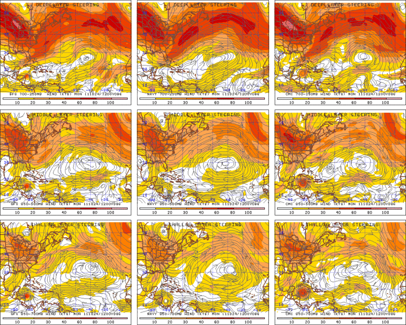
12z Forecast Steering Chart Valid for Monday morning. It forecast for the Middle and Shallow steering winds to be North to NE (meaning a SW motion) which if this stays weak enough it would be buried into CA. Now if this think bombs out in the Western Caribbean, Cuba and/or South Florida could be a likely destination.
0 likes
The following post is NOT an official forecast and should not be used as such. It is just the opinion of the poster and may or may not be backed by sound meteorological data. It is NOT endorsed by any professional institution including storm2k.org For Official Information please refer to the NHC and NWS products.
-
MGC

- S2K Supporter
- Posts: 5938
- Joined: Sun Mar 23, 2003 9:05 pm
- Location: Pass Christian MS, or what is left.
Re: SW Caribbean Tropical Development? - 20%
!8Z GFS developes a second TC south of PR after the 1st TC moves in CA.....and I'm headed to South Florida tomorrow for a week.....MGC
0 likes
-
cycloneye
- Admin
- Posts: 148730
- Age: 69
- Joined: Thu Oct 10, 2002 10:54 am
- Location: San Juan, Puerto Rico
Re: SW Caribbean Tropical Development? - 20%
Euro is on board now.


0 likes
Visit the Caribbean-Central America Weather Thread where you can find at first post web cams,radars
and observations from Caribbean basin members Click Here
and observations from Caribbean basin members Click Here
-
wzrgirl1
- S2K Supporter
- Posts: 1360
- Joined: Sat Sep 04, 2004 6:44 am
- Location: Pembroke Pines, Florida
Re: SW Caribbean Tropical Development? - 20%
Tampa_God wrote:wzrgirl1 wrote:Hopefully this will steer away from our region. We have been inundated with rain for three days straight on top of what we had the previous weekend. We need a break.
Speak for yourself. Central Fl. got barely anything from either systems, especially the west side of Tampa Bay.
I am speaking for myself. South Florida is what I was referring to.
0 likes
-
wzrgirl1
- S2K Supporter
- Posts: 1360
- Joined: Sat Sep 04, 2004 6:44 am
- Location: Pembroke Pines, Florida
Re: SW Caribbean Tropical Development? - 20%
dolebot_Broward_NW wrote:wzrgirl1 wrote:Hopefully this will steer away from our region. We have been inundated with rain for three days straight on top of what we had the previous weekend. We need a break.
No we don't. We need 23 more inches to get to the "normal" for the year and rainy season is just about over. The lake is 3 feet below where it should be. Still in a drought....
I for one (admitted weenie) am hoping it makes a show, or at least the rain does. While the freak ef2 twister over Sunrise wasn't welcome, it really was the best kind of rain we could get.
As for the system in question, I think there is a slim chance of something spinning up but that high over the plains is not looking good for any northerly movement.
I personally love when it rains but I know where I live the water is still puddled in some areas in southwest Broward, I fear if we get more rain it could flood in some areas. I know the lake is still below normal however if it could rain there it would be nice.
0 likes
-
cycloneye
- Admin
- Posts: 148730
- Age: 69
- Joined: Thu Oct 10, 2002 10:54 am
- Location: San Juan, Puerto Rico
Re: SW Caribbean Tropical Development? - 20%
0 likes
Visit the Caribbean-Central America Weather Thread where you can find at first post web cams,radars
and observations from Caribbean basin members Click Here
and observations from Caribbean basin members Click Here
-
DESTRUCTION5

- Category 5

- Posts: 4430
- Age: 44
- Joined: Wed Sep 03, 2003 11:25 am
- Location: Stuart, FL
Re: SW Caribbean Tropical Development? - 20%
The IR2 seems show some pretty good spin @79.5 - 14 this morning, just east of the convection.
Saved Euro run

Saved Euro run
0 likes
-
cycloneye
- Admin
- Posts: 148730
- Age: 69
- Joined: Thu Oct 10, 2002 10:54 am
- Location: San Juan, Puerto Rico
Re: SW Caribbean Tropical Development? - 20%
Up to 30%
TROPICAL WEATHER OUTLOOK
NWS NATIONAL HURRICANE CENTER MIAMI FL
800 AM EDT FRI OCT 21 2011
FOR THE NORTH ATLANTIC...CARIBBEAN SEA AND THE GULF OF MEXICO...
A NEARLY STATIONARY AREA OF LOW PRESSURE LOCATED OVER THE WESTERN
CARIBBEAN SEA BETWEEN NICARAGUA AND JAMAICA IS PRODUCING A LARGE
AREA OF CLOUDINESS AND THUNDERSTORMS. SURFACE PRESSURES ARE FALLING
AND UPPER-LEVEL WINDS ARE EXPECTED TO BECOME MORE FAVORABLE FOR
DEVELOPMENT. THIS SYSTEM HAS A MEDIUM CHANCE...30 PERCENT... OF
BECOMING A TROPICAL CYCLONE DURING THE NEXT 48 HOURS.
0 likes
Visit the Caribbean-Central America Weather Thread where you can find at first post web cams,radars
and observations from Caribbean basin members Click Here
and observations from Caribbean basin members Click Here
-
cycloneye
- Admin
- Posts: 148730
- Age: 69
- Joined: Thu Oct 10, 2002 10:54 am
- Location: San Juan, Puerto Rico
Re: SW Caribbean Tropical Development? - 30% (Is invest 96L)
SW Caribbean area has been tagged as invest 96L. Go to active storms.invests forum to continue the discussions about this area of interest.
viewtopic.php?f=59&t=112106&p=2201785#p2201785
viewtopic.php?f=59&t=112106&p=2201785#p2201785
0 likes
Visit the Caribbean-Central America Weather Thread where you can find at first post web cams,radars
and observations from Caribbean basin members Click Here
and observations from Caribbean basin members Click Here
Who is online
Users browsing this forum: Ulf and 47 guests