Gulf of Mexico, area of convection

This is the general tropical discussion area. Anyone can take their shot at predicting a storms path.

Moderator: S2k Moderators

Forum rules

The posts in this forum are NOT official forecasts and should not be used as such. They are just the opinion of the poster and may or may not be backed by sound meteorological data. They are NOT endorsed by any professional institution or STORM2K. For official information, please refer to products from the National Hurricane Center and National Weather Service.

Help Support Storm2K
Message
Author
tolakram
Admin
Admin
Posts: 20011
Age: 62
Joined: Sun Aug 27, 2006 8:23 pm
Location: Florence, KY (name is Mark)

Gulf of Mexico, area of convection

#1 Postby tolakram » Fri Mar 30, 2012 11:47 am

Image

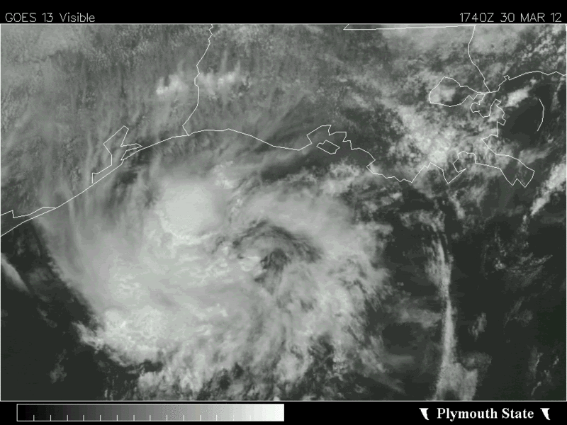
Deceiving looking area of convection, in a low shear environment. :)

Live Loop: http://wwwghcc.msfc.nasa.gov/cgi-bin/ge ... umframes=5

Water temps way above average, but too cold to support tropical IMO.
0 likes   
M a r k
- - - - -
Join us in chat: Storm2K Chatroom Invite. Android and IOS apps also available.

The posts in this forum are NOT official forecasts and should not be used as such. Posts are NOT endorsed by any professional institution or STORM2K.org. For official information and forecasts, please refer to NHC and NWS products.

User avatar
cycloneye
Admin
Admin
Posts: 145398
Age: 68
Joined: Thu Oct 10, 2002 10:54 am
Location: San Juan, Puerto Rico

Re: Gulf of Mexico (near TX), area of convection

#2 Postby cycloneye » Fri Mar 30, 2012 12:03 pm

Blob watching already Mark? :) What is true is that those GOM waters are above average and we can't discount early developments in that area.

Image

Uploaded with imageshack.us
0 likes   
Visit the Caribbean-Central America Weather Thread where you can find at first post web cams,radars
and observations from Caribbean basin members Click Here

tolakram
Admin
Admin
Posts: 20011
Age: 62
Joined: Sun Aug 27, 2006 8:23 pm
Location: Florence, KY (name is Mark)

Re: Gulf of Mexico (near TX), area of convection

#3 Postby tolakram » Fri Mar 30, 2012 12:21 pm

My place of work blocks imageshack, but not imgur. I was so excited I just had to post something, just for practice. ;)

edit: Oh, and that is along a front, as far as I can tell from the discussion.

http://www.nhc.noaa.gov/text/MIAOFFNT4.shtml

OFFSHORE WATERS FORECAST FOR THE GULF OF MEXICO
NWS NATIONAL HURRICANE CENTER MIAMI FL
1030 AM CDT FRI MAR 30 2012

OFFSHORE WATERS FORECAST FOR THE GULF OF MEXICO

SEAS GIVEN AS SIGNIFICANT WAVE HEIGHT...WHICH IS THE AVERAGE
HEIGHT OF THE HIGHEST 1/3 OF THE WAVES. INDIVIDUAL WAVES MAY BE
MORE THAN TWICE THE SIGNIFICANT WAVE HEIGHT.

GMZ089-302130-
SYNOPSIS FOR THE GULF OF MEXICO
1030 AM CDT FRI MAR 30 2012

.SYNOPSIS...ATLC RIDGE ALONG 27N WILL EXTEND INTO THE EASTERN
GULF THROUGH SAT. SOUTHERLY RETURN FLOW WILL INCREASE OVER THE
WESTERN GULF LATE SUN INTO MON AHEAD OF A COLD FRONT FORECAST TO
ENTER THE NW PORTION OF THE GULF EARLY TUE MORNING. THE FRONT
WILL REACH FROM SE LOUISIANA TO THE BAY OF CAMPECHE TUE NIGHT.

...
0 likes   
M a r k
- - - - -
Join us in chat: Storm2K Chatroom Invite. Android and IOS apps also available.

The posts in this forum are NOT official forecasts and should not be used as such. Posts are NOT endorsed by any professional institution or STORM2K.org. For official information and forecasts, please refer to NHC and NWS products.

tolakram
Admin
Admin
Posts: 20011
Age: 62
Joined: Sun Aug 27, 2006 8:23 pm
Location: Florence, KY (name is Mark)

Re: Gulf of Mexico (near TX), area of convection

#4 Postby tolakram » Fri Mar 30, 2012 12:40 pm

Edit to the above. Not frontal, the front won't arrive till Tuesday, so what is driving the convection? Some sort of upper level disturbance?

http://www.ndbc.noaa.gov/station_page.php?station=42046
Image

http://www.ndbc.noaa.gov/station_page.php?station=42043
Image


Surface disturbance?
0 likes   
M a r k
- - - - -
Join us in chat: Storm2K Chatroom Invite. Android and IOS apps also available.

The posts in this forum are NOT official forecasts and should not be used as such. Posts are NOT endorsed by any professional institution or STORM2K.org. For official information and forecasts, please refer to NHC and NWS products.

User avatar
northjaxpro
S2K Supporter
S2K Supporter
Posts: 8900
Joined: Mon Sep 27, 2010 11:21 am
Location: Jacksonville, FL

#5 Postby northjaxpro » Fri Mar 30, 2012 1:36 pm

According to NHC Tropical Weather Discussion, that area in the NW GOM is a weak shortwave impulse embedded within the southwesterly upper level wind flow.

It definitely looks interesting, but that area is nothing significant for the time being. However, just the fact that this thread has started a blob watch already at the end of March is interesting in itself for sure.
Last edited by northjaxpro on Fri Mar 30, 2012 1:45 pm, edited 1 time in total.
0 likes   
NEVER, EVER SAY NEVER in the tropics and weather in general, and most importantly, with life itself!!

________________________________________________________________________________________

Fay 2008 Beryl 2012 Debby 2012 Colin 2016 Hermine 2016 Julia 2016 Matthew 2016 Irma 2017 Dorian 2019

User avatar
wxman57
Moderator-Pro Met
Moderator-Pro Met
Posts: 22980
Age: 67
Joined: Sat Jun 21, 2003 8:06 pm
Location: Houston, TX (southwest)

Re: Gulf of Mexico (near TX), area of convection

#6 Postby wxman57 » Fri Mar 30, 2012 1:44 pm

There's nothing at the surface now, though I could identify a weak trof along the TX coast this morning. SSTs are in the 23C-24C range beneath the storms. Wind shear is 20-30 kts. Not exactly ideal conditions for any development.
0 likes   

tolakram
Admin
Admin
Posts: 20011
Age: 62
Joined: Sun Aug 27, 2006 8:23 pm
Location: Florence, KY (name is Mark)

Re: Gulf of Mexico (near TX), area of convection

#7 Postby tolakram » Fri Mar 30, 2012 1:53 pm

Thanks for the info. It will be inland soon as well.

Sat is in rapid scan mode now, probably for the possible severe weather this afternoon in the Ohio Valley.

Live Loop: http://wwwghcc.msfc.nasa.gov/cgi-bin/ge ... umframes=5
0 likes   
M a r k
- - - - -
Join us in chat: Storm2K Chatroom Invite. Android and IOS apps also available.

The posts in this forum are NOT official forecasts and should not be used as such. Posts are NOT endorsed by any professional institution or STORM2K.org. For official information and forecasts, please refer to NHC and NWS products.

User avatar
somethingfunny
ChatStaff
ChatStaff
Posts: 3926
Age: 37
Joined: Thu May 31, 2007 10:30 pm
Location: McKinney, Texas

Re: Gulf of Mexico (near TX), area of convection

#8 Postby somethingfunny » Fri Mar 30, 2012 2:19 pm

It really is pretty neat looking, isn't it? :D It caught the NWS off guard when it formed.

National Weather Service Forecast Office, Fort Worth, TX wrote:AREA FORECAST DISCUSSION
NATIONAL WEATHER SERVICE FORT WORTH TX
325 PM CDT WED MAR 28 2012

.DISCUSSION...
THE FORECAST FOR THE NEXT 48/60 HOURS HAS TRANSITIONED FROM
BEING RELATIVELY STRAIGHT FORWARD TO COMPLICATED. OVER THE PAST
SEVERAL DAYS COMPUTER MODELS HAVE BEEN PROGGING A WEAK DISTURBANCE
TO SLOWLY PROGRESS OUT OF NORTHERN MEXICO...NORTHWARD INTO OUR
CWA ON FRIDAY. THIS WOULD HAVE BROUGHT SCATTERED AFTERNOON
CONVECTION INTO MUCH OF THE FORECAST AREA FRIDAY AFTERNOON. THINGS
WENT A LITTLE DIFFERENT YESTERDAY EVENING. THIS WEAK DISTURBANCE
BROUGHT A FAIRLY POTENT MCS TO THE BIG BEND/HILL COUNTRY
YESTERDAY EVENING AND OVERNIGHT. IN RETURN...THE WEAK DISTURBANCE
TRANSITIONED INTO A CLOSED LOW...OR A VORT LOW...MOST LIKELY DUE
TO THE EFFECT OF LATENT HEAT RELEASE. WE HAVE SAID THIS SEVERAL
TIMES THIS YEAR...BUT THIS WAS ATYPICAL FOR MARCH AND MORE LIKE A
MAY/JUNE EVENT.
NEVERTHELESS...THIS PROCESS HAS THROWN A KINK INTO
THE FORECAST FOR THE NEXT COUPLE OF DAYS.
LUCKILY...THIS LOW
DEEPENED OVER DEL RIO AND WAS SAMPLED FAIRLY WELL BY THE 12Z
SOUNDING AT KDRT AND INGESTED IN THE 12Z GUIDANCE. ALL MEMBERS
SEEM TO HAVE INITIALIZE THIS FEATURE QUITE WELL AND TRACK IT
SLOWLY TO THE EAST OVER THE NEXT 24 HOURS. INSTEAD OF A SLOWLY
NORTHWARD MOVING DISTURBANCE THAT INITIATES CONVECTION OVER THE
NEXT COUPLE OF AFTERNOONS...WE NOW HAVE A MUCH STRONGER
CIRCULATION THAT IS PROGGED TO MOVE EAST AND WILL ONLY BRING WEAK
LIFT TO OUR SOUTHERN ZONES. CONVECTION IS ONGOING ACROSS THE
SOUTHERN ZONES AND WILL LINGER 20 POPS ACROSS THE SOUTH THROUGH
TOMORROW TO ACCOUNT FOR THIS LOW.

THERE IS ANOTHER SUBTLE DISTURBANCE NOTED ON WATER VAPOR IMAGERY
IN NORTHERN MEXICO MOVING IN THE SAME TRACK AS OUR PREVIOUS
DISTURBANCE. CURRENT GUIDANCE SUGGEST THAT THIS LOW WILL REMAIN
WEAK AND MAINLY MOVE SOUTH OF THE FORECAST AREA. NONE OF THE
GUIDANCE SUGGESTS WE COULD SEE ANOTHER EPISODE WITH PERSISTENT AND
DEEP CONVECTION LEADING TO AN INTENSIFICATION OF THIS SHORTWAVE.
HOWEVER...NONE OF THE GUIDANCE SAW IT WITH LAST NIGHTS EVENT.
NEVERTHELESS...WILL KEEP LOW POPS IN THE SOUTHERN ZONES ON FRIDAY
TO ACCOUNT FOR ANY ACTIVITY.

.......

85/NH

&&


Is it going to turn tropical and warm-core? Probably not, but it has happened with these kinds of systems before. Not in March, but as pretty much every meteorologist has mentioned at some point this month.... the pattern right now is more typical of May or June than of March. Ya never know with weather.
0 likes   
I am not a meteorologist, and any posts made by me are not official forecasts or to be interpreted as being intelligent. These posts are just my opinions and are probably silly opinions.

User avatar
Ptarmigan
Category 5
Category 5
Posts: 5313
Joined: Wed Aug 16, 2006 9:06 pm

Re: Gulf of Mexico (near TX), area of convection

#9 Postby Ptarmigan » Fri Mar 30, 2012 2:23 pm

There have been records of tropical cyclones hitting Texas in April, one in 1554 which hit Brownsville.

http://www.hpc.ncep.noaa.gov/research/txhur.pdf
0 likes   

User avatar
KatDaddy
Category 5
Category 5
Posts: 2815
Joined: Mon Oct 21, 2002 6:23 pm
Location: League City, Texas

#10 Postby KatDaddy » Fri Mar 30, 2012 3:26 pm

Must say it does look rather interesting regardless. Not expecting any development.
0 likes   
The following post is NOT an official forecast and should not be used as such. It is just the opinion of the poster and may or may not be backed by sound meteorological data. It is NOT endorsed by any professional institution including storm2k.org For Official Information please refer to the NHC and NWS products.

User avatar
MGC
S2K Supporter
S2K Supporter
Posts: 5899
Joined: Sun Mar 23, 2003 9:05 pm
Location: Pass Christian MS, or what is left.

Re: Gulf of Mexico (near TX), area of convection

#11 Postby MGC » Fri Mar 30, 2012 5:19 pm

Glad its not June.....MGC
0 likes   

User avatar
NDG
S2K Supporter
S2K Supporter
Posts: 15446
Joined: Sun Jul 09, 2006 10:14 pm
Location: Orlando, FL

#12 Postby NDG » Fri Mar 30, 2012 5:27 pm

Impressive as many have mentioned.

Image
0 likes   

User avatar
Hurricane Jed
Category 2
Category 2
Posts: 545
Age: 37
Joined: Mon Jan 24, 2011 3:36 pm
Location: Cen Tex

#13 Postby Hurricane Jed » Fri Mar 30, 2012 9:01 pm

Certainly looks subtropical at least.
0 likes   

User avatar
Hurricaneman
Category 5
Category 5
Posts: 7351
Age: 45
Joined: Tue Aug 31, 2004 3:24 pm
Location: central florida

Re: Gulf of Mexico (near TX), area of convection

#14 Postby Hurricaneman » Fri Mar 30, 2012 11:35 pm

We should not be seeing things like this before May. Does anyone get the feeling there will be a pre-season storm this year from something similar
0 likes   

User avatar
northjaxpro
S2K Supporter
S2K Supporter
Posts: 8900
Joined: Mon Sep 27, 2010 11:21 am
Location: Jacksonville, FL

#15 Postby northjaxpro » Sat Mar 31, 2012 4:30 am

This has been an impressive Mesoscale Convective Vortex. This feature originated from across South Central Texas and has steadily moved east-northeast for the past 36 hours. This MCV has remained intact quite well tracking along the Northern Gulf coastal region. Radar and satellite presentation this early morning showed the MCV spinning quite well just offshore of the Mississippi and Alabama coasts moving east. It will move inland across the far western Florida panhandle later today.

It is an interesting feature for sure. There will be some very heavy rains (which are already occuring) across the Florida panhandle, extreme Southern Alabama and portions of the coastal Northern Gulf Coast region as this feature moves east.
0 likes   
NEVER, EVER SAY NEVER in the tropics and weather in general, and most importantly, with life itself!!

________________________________________________________________________________________

Fay 2008 Beryl 2012 Debby 2012 Colin 2016 Hermine 2016 Julia 2016 Matthew 2016 Irma 2017 Dorian 2019

Dean4Storms
S2K Supporter
S2K Supporter
Posts: 6358
Age: 62
Joined: Sun Aug 31, 2003 1:01 pm
Location: Miramar Bch. FL

#16 Postby Dean4Storms » Sat Mar 31, 2012 5:04 am

Brought us some good Storms here in Destin this morning.
0 likes   

User avatar
NDG
S2K Supporter
S2K Supporter
Posts: 15446
Joined: Sun Jul 09, 2006 10:14 pm
Location: Orlando, FL

#17 Postby NDG » Sat Mar 31, 2012 3:19 pm

Our little vorticity just can't quit, C-Man station south of Apalachicola reporting steady winds above 30 knots (anemometer 100' + above water) for the past hour with a nice drop of pressure as the vorticity passed close to it.

Image
0 likes   

User avatar
northjaxpro
S2K Supporter
S2K Supporter
Posts: 8900
Joined: Mon Sep 27, 2010 11:21 am
Location: Jacksonville, FL

#18 Postby northjaxpro » Sat Mar 31, 2012 4:17 pm

Yeah, NDG, that MCV was an impressive feature, staying intact on its trek quickly along the entire Gulf Coast, now moving in from Apalachee Bay across the northern Florida peninsula.

Good thing this feature was moving along at a quick pace and also that its the end of March, not May or June. However, we sure are in a pattern that is very May or June like right now, and this may be a harbinger of things to come in the Gulf of Mexico this upcoming season. I am anticipating more in the way of "homebrew tropical systems" with the onset of El-Nino returning.
0 likes   
NEVER, EVER SAY NEVER in the tropics and weather in general, and most importantly, with life itself!!

________________________________________________________________________________________

Fay 2008 Beryl 2012 Debby 2012 Colin 2016 Hermine 2016 Julia 2016 Matthew 2016 Irma 2017 Dorian 2019


Return to “Talkin' Tropics”

Who is online

Users browsing this forum: cheezyWXguy and 40 guests