Wind Shear and Saharan Air Layer thoughts

This is the general tropical discussion area. Anyone can take their shot at predicting a storms path.

Moderator: S2k Moderators

Forum rules

The posts in this forum are NOT official forecasts and should not be used as such. They are just the opinion of the poster and may or may not be backed by sound meteorological data. They are NOT endorsed by any professional institution or STORM2K. For official information, please refer to products from the National Hurricane Center and National Weather Service.

Help Support Storm2K
Message
Author
arp2559
Tropical Wave
Tropical Wave
Posts: 6
Joined: Thu May 31, 2012 11:10 pm

Wind Shear and Saharan Air Layer thoughts

#1 Postby arp2559 » Fri Jun 01, 2012 11:35 pm

Image
Image

The top image is the Saharan Air Layer. It appears modest when compared to prior years at this time. The second image is the rainfall anomaly across Africa for April. The rainfall anomaly was average to slightly below average. I will be interested to see what the rainfall was for May, as there has been no major dust storm rolling off the coast. If you have followed the Saharan Air Layer over the years, there is usually nothing but dust all the down to 10N.

Take a look at this dust storm from July 18, 2005: http://www.youtube.com/watch?feature=pl ... ZsYDRQRJ1A

Again, for June 1st, the Saharan Air Layer is weak and especially so in light of the African rainfall.

Image

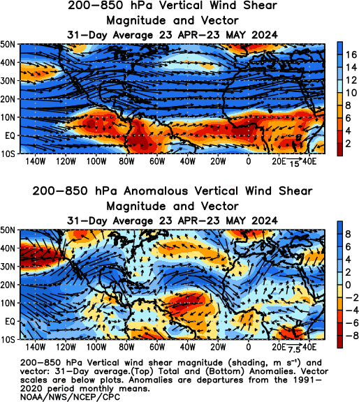
The bottom picture is the 31 day wind shear anomaly from April 30-May 30. It shows lower wind shear anomalies in the MDR. Such favorable wind shear anomalies, if present in Aug-Oct, would be worrisome. The GFS runs for the past few days have shown that this lower wind shear anomaly will continue over the next 10 days. I'm not so much looking for development during this time as I am more interested in the overall pattern.

Image

Finally, the image above shows the wind shear in the Atlantic was above climatology through April. However, it flipped in May and we are now running below average wind shear relative to climatology. Wind shear vs. climatology and the Saharan air layer are two pieces of information I like to focus on in the early season to note any patterns. ENSO can change everything, but it appears neutral is the prevailing state for this season. Should ENSO neutral prevail, it will be very interesting to follow these two metrics in the months ahead.
0 likes   

User avatar
cycloneye
Admin
Admin
Posts: 145398
Age: 68
Joined: Thu Oct 10, 2002 10:54 am
Location: San Juan, Puerto Rico

Re: Wind Shear and Saharan Air Layer thoughts

#2 Postby cycloneye » Sat Jun 02, 2012 5:54 am

Welcome to Storm2k. This is a good topic to discuss as it will be very important down the road when the peak of the season arrives,how these factors will be by then.
0 likes   
Visit the Caribbean-Central America Weather Thread where you can find at first post web cams,radars
and observations from Caribbean basin members Click Here

User avatar
brunota2003
S2K Supporter
S2K Supporter
Posts: 9476
Age: 34
Joined: Sat Jul 30, 2005 9:56 pm
Location: Stanton, KY...formerly Havelock, NC
Contact:

#3 Postby brunota2003 » Sat Jun 02, 2012 11:33 am

Another thing of interest will be the wind shear off of the east coast. A lot of homebrews like to kick off there. Also, if the wind shear is lesser than normal, there is more of a chance of systems like Isabel or Irene actually keeping their intensity as they barrel up toward the east coast, instead of losing them, because there is no shear to force drier air into the system's circulation.
0 likes   
Just a small town southern boy helping other humans.

User avatar
TropicalAnalystwx13
Category 5
Category 5
Posts: 2109
Age: 28
Joined: Tue Jul 19, 2011 8:20 pm
Location: Wilmington, NC
Contact:

#4 Postby TropicalAnalystwx13 » Sat Jun 02, 2012 12:54 pm

The Eastern Atlantic isn't the only place with below average to average wind shear...it's the whole Atlantic. In addition, vertical instability has made a full comeback. For those that don't know its impacts on the Atlantic, remember last year: A high number of tropical storms but a low number of hurricanes and major hurricanes. Low vertical instability limits storms' abilities to become strong.

Gulf Shear:

Image

Caribbean Shear:

Image

East Coast Shear:

Image

Subtropical Atlantic Shear:

Image
0 likes   

User avatar
NDG
S2K Supporter
S2K Supporter
Posts: 15446
Joined: Sun Jul 09, 2006 10:14 pm
Location: Orlando, FL

Re: Wind Shear and Saharan Air Layer thoughts

#5 Postby NDG » Sat Jun 02, 2012 5:28 pm

ACE of 120 forecasted by the FSU team probably has to do from conditions in the Atlantic not being horrible at all.
0 likes   


Return to “Talkin' Tropics”

Who is online

Users browsing this forum: cheezyWXguy, Google Adsense [Bot] and 40 guests