The MJO forecast on the GFS stays in the circle while the Euro goes to phase 2 which is why the Euro is developing something at the end of the run while the GFS is quiet
The posts in this forum are NOT official forecast and should not be used as such. They are just the opinion of the poster and may or may not be backed by sound meteorological data. They are NOT endorsed by any professional institution or storm2k.org. For official information, please refer to the NHC and NWS products
2013 Steering Pattern / Early indicators
Moderator: S2k Moderators
Forum rules

The posts in this forum are NOT official forecasts and should not be used as such. They are just the opinion of the poster and may or may not be backed by sound meteorological data. They are NOT endorsed by any professional institution or STORM2K. For official information, please refer to products from the National Hurricane Center and National Weather Service.
-
Hurricaneman

- Category 5

- Posts: 7404
- Age: 45
- Joined: Tue Aug 31, 2004 3:24 pm
- Location: central florida


Re: 2013 Steering Pattern / Early indicators
Its too early to tell but maybe the east coast trough will be around to deflect all the storms away from the US
0 likes


-
'CaneFreak

- Category 5
- Posts: 1487
- Joined: Mon Jun 05, 2006 10:50 am
- Location: New Bern, NC
Precisely why we need to stop worrying so much about the "east coast trough" that so many here have been harping on for the past few weeks. In a true, typical neutral ENSO pattern, no real pattern tends to stick around for long. For evidence of that, folks should just go back and look at the tracks of the hurricanes in the infamous ENSO neutral 2005 hurricane season. They were all over the place. Some recurved, some hit the US, some hit the Caribbean, etc.
0 likes
-
tolakram
- Admin

- Posts: 20168
- Age: 62
- Joined: Sun Aug 27, 2006 8:23 pm
- Location: Florence, KY (name is Mark)
Re: 2013 Steering Pattern / Early indicators
I'm not sure people making the trough statement really understand the long term picture. Troughs will come and go, it's persistence that's the key. The main concern I see is a trough will pull a storm up towards the north, then the ridge will re-build and turn the storm into the coast. IMO
0 likes
M a r k
- - - - -
Join us in chat: Storm2K Chatroom Invite. Android and IOS apps also available.
The posts in this forum are NOT official forecasts and should not be used as such. Posts are NOT endorsed by any professional institution or STORM2K.org. For official information and forecasts, please refer to NHC and NWS products.
-
'CaneFreak
- Category 5
- Posts: 1487
- Joined: Mon Jun 05, 2006 10:50 am
- Location: New Bern, NC
Take a look at these CPC analog patterns for the upcoming 6-10 and 8-14 day time frames as we head into August. What do we see? A great lakes/interior northeast trough with a deep seated subtropical ridge that spans most of the Atlantic. Not exactly a recurvature type of pattern if you ask me...
6-10 Day Analog:

8-14 Day Analog:

6-10 Day Analog:

8-14 Day Analog:

0 likes


One of our posters mentioned 2001 as a hunch for similarities this August. I decided to pull up the SST's and well they seem to match up pretty well, not perfect but not that far off.


Being neutral after a period of Ninas as well. Big ones came in September and October.
Being neutral after a period of Ninas as well. Big ones came in September and October.
0 likes
The above post and any post by Ntxw is NOT an official forecast and should not be used as such. It is just the opinion of the poster and may or may not be backed by sound meteorological data. It is NOT endorsed by any professional institution including Storm2k. For official information, please refer to NWS products.
Help support Storm2K!
-
Hurricaneman
- Category 5
- Posts: 7404
- Age: 45
- Joined: Tue Aug 31, 2004 3:24 pm
- Location: central florida
Re: 2013 Steering Pattern / Early indicators
The models are doing something strange in the next week to 10 days with the MJO, most of them including the Euro back it up from phase 3 to phase 2 which is very rare and could cause a very active period within the next 15 days
The posts in this forum are NOT official forecast and should not be used as such. They are just the opinion of the poster and may or may not be backed by sound meteorological data. They are NOT endorsed by any professional institution or storm2k.org. For official information, please refer to the NHC and NWS products
The posts in this forum are NOT official forecast and should not be used as such. They are just the opinion of the poster and may or may not be backed by sound meteorological data. They are NOT endorsed by any professional institution or storm2k.org. For official information, please refer to the NHC and NWS products
0 likes
0 likes
The above post and any post by Ntxw is NOT an official forecast and should not be used as such. It is just the opinion of the poster and may or may not be backed by sound meteorological data. It is NOT endorsed by any professional institution including Storm2k. For official information, please refer to NWS products.
Help support Storm2K!
Help support Storm2K!
-
ninel conde
https://twitter.com/BigJoeBastardi/stat ... 32/photo/1
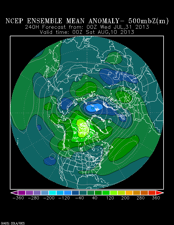
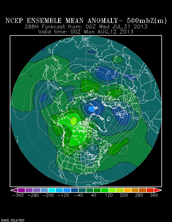
lets assume this pattern verifies. with the magnitude of the cold it implies we will have a powerful neg NAO. its also clear there is a big trof off the east coast. this is my opinion only, not the NHC, but the whole US coastline would be protected as we would have a strong winterlike northwest flow across the eastern US between the low in se canada and high over texas. the high over texas will also protect texas. my guess would be IF anything were able to develop it would be in the BOC and its only path would be into southern mexico. finally, if this pattern persists into sept then its extremely possible, barring a fluke event, that no hurricane will hit the US.
The posts in this forum are NOT official forecast and should not be used as such. They are just the opinion of the poster and may or may not be backed by sound meteorological data. They are NOT endorsed by any professional institution or storm2k.org. For official information, please refer to the NHC and NWS products.
0 likes
-
'CaneFreak
- Category 5
- Posts: 1487
- Joined: Mon Jun 05, 2006 10:50 am
- Location: New Bern, NC
Re:
Actually, if the cold anomaly you are seeing across the eastern US persists, this could be a pattern that may actually draw hurricanes into the US Gulf Coast and East Coast.
ninel conde wrote:https://twitter.com/BigJoeBastardi/status/363255056579039232/photo/1
lets assume this pattern verifies. with the magnitude of the cold it implies we will have a powerful neg NAO. its also clear there is a big trof off the east coast. this is my opinion only, not the NHC, but the whole US coastline would be protected as we would have a strong winterlike northwest flow across the eastern US between the low in se canada and high over texas. the high over texas will also protect texas. my guess would be IF anything were able to develop it would be in the BOC and its only path would be into southern mexico. finally, if this pattern persists into sept then its extremely possible, barring a fluke event, that no hurricane will hit the US.
0 likes
-
ninel conde
Re: Re:
'CaneFreak wrote:Actually, if the cold anomaly you are seeing across the eastern US persists, this could be a pattern that may actually draw hurricanes into the US Gulf Coast and East Coast.ninel conde wrote:https://twitter.com/BigJoeBastardi/status/363255056579039232/photo/1
lets assume this pattern verifies. with the magnitude of the cold it implies we will have a powerful neg NAO. its also clear there is a big trof off the east coast. this is my opinion only, not the NHC, but the whole US coastline would be protected as we would have a strong winterlike northwest flow across the eastern US between the low in se canada and high over texas. the high over texas will also protect texas. my guess would be IF anything were able to develop it would be in the BOC and its only path would be into southern mexico. finally, if this pattern persists into sept then its extremely possible, barring a fluke event, that no hurricane will hit the US.
you would be correct if the cold were centered in the midwest west of the appilacians and temps were forecast above normal along the east coast. that would mean the atlatic ridge was strong. similar to 2004.
0 likes
-
'CaneFreak
- Category 5
- Posts: 1487
- Joined: Mon Jun 05, 2006 10:50 am
- Location: New Bern, NC
Re: Re:
The Atlantic ridge doesn't need to be strong to send hurricanes into the EC and GOM even in that pattern.
ninel conde wrote:you would be correct if the cold were centered in the midwest west of the appilacians and temps were forecast above normal along the east coast. that would mean the atlatic ridge was strong. similar to 2004.
0 likes


-
cycloneye

- Admin
- Posts: 148726
- Age: 69
- Joined: Thu Oct 10, 2002 10:54 am
- Location: San Juan, Puerto Rico
Re: 2013 Steering Pattern / Early indicators
Ntxw what is the latest MJO forecast? I know this factor is not essential during the peak months of the season,but it can boost developments.
0 likes
Visit the Caribbean-Central America Weather Thread where you can find at first post web cams,radars
and observations from Caribbean basin members Click Here
and observations from Caribbean basin members Click Here
Re: 2013 Steering Pattern / Early indicators
cycloneye wrote:Ntxw what is the latest MJO forecast? I know this factor is not essential during the peak months of the season,but it can boost developments.
Unfortunately the MJO remains too weak and is forecasted to remain that way, inside the circle. GFS keeps pushing it to P8/P1 for weeks but have yet to verify. No MT event is in the offing therefore no big westerly push for the MJO to kick up and move. It will likely not be a huge contributor or deterrent to activity for the next 1-2 weeks.
0 likes
The above post and any post by Ntxw is NOT an official forecast and should not be used as such. It is just the opinion of the poster and may or may not be backed by sound meteorological data. It is NOT endorsed by any professional institution including Storm2k. For official information, please refer to NWS products.
Help support Storm2K!
Help support Storm2K!
Who is online
Users browsing this forum: No registered users and 74 guests