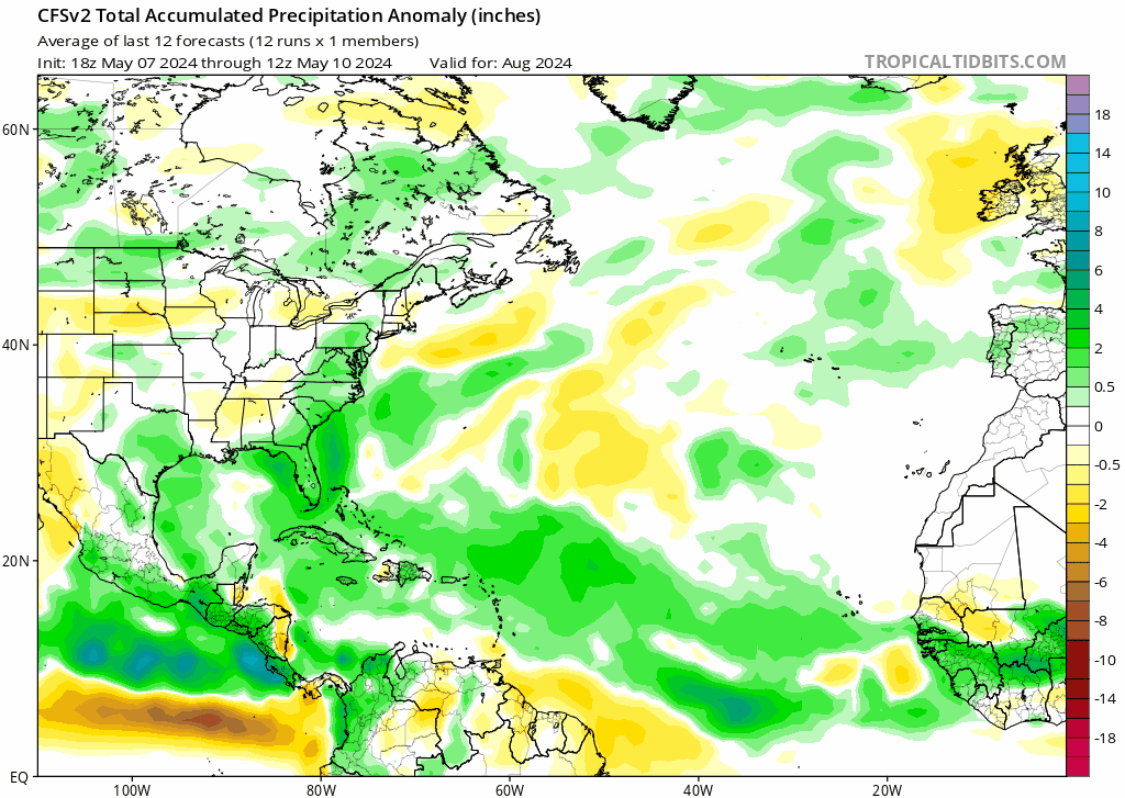
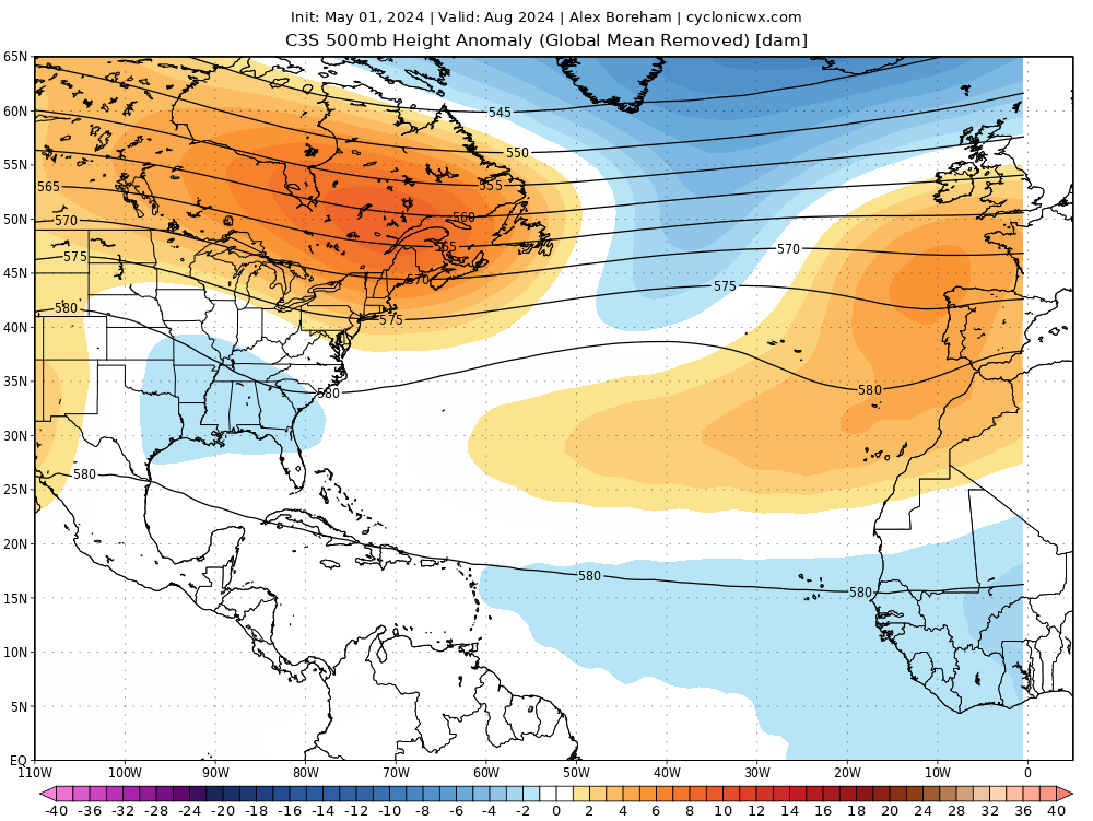
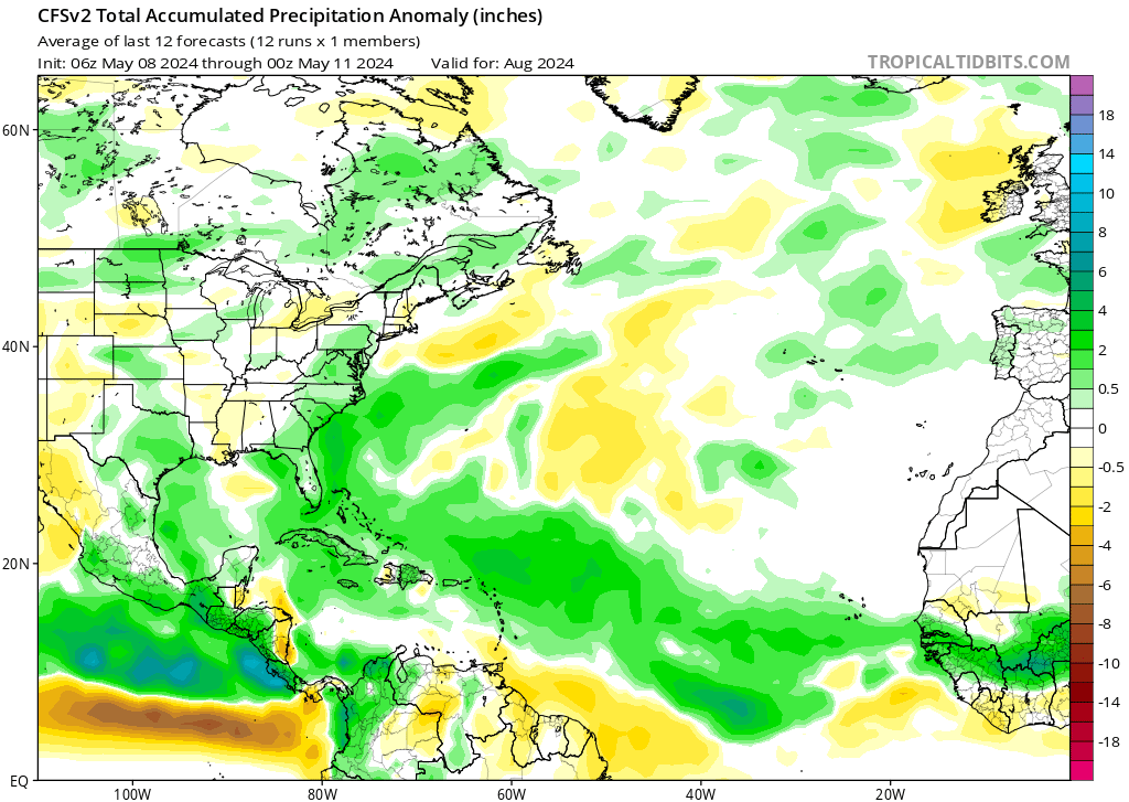
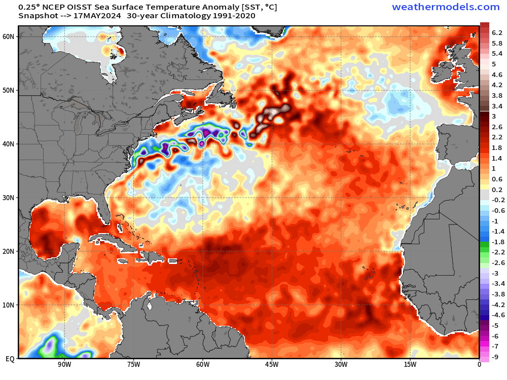
2024 Indicators: SST's, MSLP, Shear, SAL, Steering, Instability (Day 16+ Climate Models)

This is the general tropical discussion area. Anyone can take their shot at predicting a storms path.

Moderator: S2k Moderators

Forum rules

The posts in this forum are NOT official forecasts and should not be used as such. They are just the opinion of the poster and may or may not be backed by sound meteorological data. They are NOT endorsed by any professional institution or STORM2K. For official information, please refer to products from the National Hurricane Center and National Weather Service.

Help Support Storm2K
Message
Author
User avatar
skyline385
Category 5
Category 5
Posts: 2575
Age: 33
Joined: Wed Aug 26, 2020 11:15 pm
Location: Houston TX

Re: 2024 Indicators: SST's, MSLP, Shear, SAL, Steering, Instability (Day 16+ Climate Models)

#961 Postby skyline385 » Sat May 18, 2024 12:41 am

LarryWx wrote:
skyline385 wrote:Talking about SSTs, we have areas of 30.5-31C SSTs developing in the NATL. I couldn't find any other year where 31C SSTs formed around mid-May. 2023 was the closest to it.

[url]https://i.postimg.cc/nzm8sQMn/image.png [/url]

[url]https://i.postimg.cc/kGP0WXtK/image.png [/url]


The Key West buoy, a legit deep water buoy, averaged ~30.5C during May 15-17, well above normal:

https://www.ndbc.noaa.gov/data/realtime2/KYWF1.txt


On 5/15-17/23, it was “only” 29.1C:

https://www.ndbc.noaa.gov/view_text_fil ... al/stdmet/

However, from 5/19/23 forward, it reached and soon after exceeded 30.5C and stayed that way through August!


Yea SFL had a record breaking heatwave last week and Key West in particular recorded a heat index of 115F which broke the previous May heat index record by 17F which is just an incredible number. The heat index of 115F recorded on 05/15/2024 tied with the all time high record 2 months ahead of schedule so that might explain why the waters there are also burning hot.
0 likes   

User avatar
skyline385
Category 5
Category 5
Posts: 2575
Age: 33
Joined: Wed Aug 26, 2020 11:15 pm
Location: Houston TX

Re: 2024 Indicators: SST's, MSLP, Shear, SAL, Steering, Instability (Day 16+ Climate Models)

#962 Postby skyline385 » Sat May 18, 2024 12:50 am

I find the recent trend in August precipitation on the CFS very interesting. Over the course of 30 runs, it has slowly trended towards a drier western GOM. Going to be interesting to see what next month's climate models show.

Image
1 likes   

User avatar
chaser1
S2K Supporter
S2K Supporter
Posts: 4751
Age: 63
Joined: Sat Oct 15, 2005 5:59 pm
Location: Longwood, Fl

Re: 2024 Indicators: SST's, MSLP, Shear, SAL, Steering, Instability (Day 16+ Climate Models)

#963 Postby chaser1 » Sat May 18, 2024 1:33 am

skyline385 wrote:I find the recent trend in August precipitation on the CFS very interesting. Over the course of 30 runs, it has slowly trended towards a drier western GOM. Going to be interesting to see what next month's climate models show.

[url]https://i.postimg.cc/X7v40QkS/cfs-mon-01-apcpna-month-atl-fh3-trend-1.gif [/url]


.... and a dryer southern and far west/northwestern Caribbean as well.
0 likes   
Personal Forecast Disclaimer:
The posts in this forum are NOT official forecast and should not be used as such. They are just the opinion of the poster and may or may not be backed by sound meteorological data. They are NOT endorsed by any professional institution or storm2k.org. For official information, please refer to the NHC and NWS products.


User avatar
Cpv17
Category 5
Category 5
Posts: 4426
Joined: Wed Dec 07, 2016 2:24 pm
Location: Wharton/El Campo, TX

Re: 2024 Indicators: SST's, MSLP, Shear, SAL, Steering, Instability (Day 16+ Climate Models)

#964 Postby Cpv17 » Sat May 18, 2024 10:05 am

skyline385 wrote:I find the recent trend in August precipitation on the CFS very interesting. Over the course of 30 runs, it has slowly trended towards a drier western GOM. Going to be interesting to see what next month's climate models show.

[url]https://i.postimg.cc/X7v40QkS/cfs-mon-01-apcpna-month-atl-fh3-trend-1.gif [/url]


I mean, I can see that happening after mid September, but in August? No. That’s basically shutting down 2/3 of the Gulf.
1 likes   

User avatar
skyline385
Category 5
Category 5
Posts: 2575
Age: 33
Joined: Wed Aug 26, 2020 11:15 pm
Location: Houston TX

Re: 2024 Indicators: SST's, MSLP, Shear, SAL, Steering, Instability (Day 16+ Climate Models)

#965 Postby skyline385 » Sat May 18, 2024 10:40 am

Cpv17 wrote:
skyline385 wrote:I find the recent trend in August precipitation on the CFS very interesting. Over the course of 30 runs, it has slowly trended towards a drier western GOM. Going to be interesting to see what next month's climate models show.

[url]https://i.postimg.cc/X7v40QkS/cfs-mon-01-apcpna-month-atl-fh3-trend-1.gif [/url]


I mean, I can see that happening after mid September, but in August? No. That’s basically shutting down 2/3 of the Gulf.


Why not? The classical +AMO setup certainly supports it and It happened in 2010 which is one of the top analogues for this season. It's all going to come down to how unstable the east MDR will be and that might come down to the state of Atlantic Nino in August. If we run into a situation like 2005 where the waves really struggle to get going in the eastern MDR only to blow up on reaching the Lesser Antilles because of lack on instability near CV, then yea it won't verify. But if waves get going immediately after coming offshore then it certainly supports a scenario in which they concentrate on the eastern GoM or recurve ahead of it.

Keep in mind that the CFS trend is not saying that the GoM will be completely safe but rather that the anomalies will be more concentrated on the eastern side from MS to Florida within the GoM which is certainly a possibility regardless of the activity in the MDR.

The last C3S 500mb plot also somewhat supported this setup where there it shows a gap in the ridging in the open Atlantic for developed systems to recurve out to and another and another trough over SE US for systems that don't make it out in the open Atlantic.

Image
Last edited by skyline385 on Sat May 18, 2024 10:46 am, edited 1 time in total.
1 likes   

User avatar
Cpv17
Category 5
Category 5
Posts: 4426
Joined: Wed Dec 07, 2016 2:24 pm
Location: Wharton/El Campo, TX

Re: 2024 Indicators: SST's, MSLP, Shear, SAL, Steering, Instability (Day 16+ Climate Models)

#966 Postby Cpv17 » Sat May 18, 2024 10:46 am

skyline385 wrote:
Cpv17 wrote:
skyline385 wrote:I find the recent trend in August precipitation on the CFS very interesting. Over the course of 30 runs, it has slowly trended towards a drier western GOM. Going to be interesting to see what next month's climate models show.

[url]https://i.postimg.cc/X7v40QkS/cfs-mon-01-apcpna-month-atl-fh3-trend-1.gif [/url]


I mean, I can see that happening after mid September, but in August? No. That’s basically shutting down 2/3 of the Gulf.


Why not? The classical +AMO setup certainly supports it and It happened in 2010 which is one of the top analogues for this season. It's all going to come down to how unstable the east MDR will be and that might come down to the state of Atlantic Nino in August. If we run into a situation like 2005 where the waves really struggle to get going in the eastern MDR only to blow up on reaching the Lesser Antilles because of lack on instability near CV, then yea it won't verify. But if waves get going immediately after coming offshore then it certainly supports a scenario in which they concentrate on the eastern GoM or recurve ahead of it. Keep in mind that the CFS trend is not saying that the GoM will be completely safe but rather that the anomalies will be more concentrated on the eastern side from MS to Florida within the GoM which is absolutely possible regardless of the activity in the MDR.

The last C3S 500mb plot also somewhat supported this setup where there it shows a gap in the ridging in the open Atlantic for developed systems to recurve out to and another and another trough over SE US for systems that don't make it out in the open Atlantic.

[url]https://i.postimg.cc/wxtNHNp3/c3s-atl-z500a-2024050100-f003.png [/url]


It’s hard to believe because it’s such an abrupt turn from everything we’ve seen over the past few months. It’s even shutting down the Caribbean compared to what other models have shown. I’d need to see other guidance jump on this idea before I start to believe the CFS.
0 likes   

User avatar
skyline385
Category 5
Category 5
Posts: 2575
Age: 33
Joined: Wed Aug 26, 2020 11:15 pm
Location: Houston TX

Re: 2024 Indicators: SST's, MSLP, Shear, SAL, Steering, Instability (Day 16+ Climate Models)

#967 Postby skyline385 » Sat May 18, 2024 11:03 am

Cpv17 wrote:
skyline385 wrote:
Cpv17 wrote:
I mean, I can see that happening after mid September, but in August? No. That’s basically shutting down 2/3 of the Gulf.


Why not? The classical +AMO setup certainly supports it and It happened in 2010 which is one of the top analogues for this season. It's all going to come down to how unstable the east MDR will be and that might come down to the state of Atlantic Nino in August. If we run into a situation like 2005 where the waves really struggle to get going in the eastern MDR only to blow up on reaching the Lesser Antilles because of lack on instability near CV, then yea it won't verify. But if waves get going immediately after coming offshore then it certainly supports a scenario in which they concentrate on the eastern GoM or recurve ahead of it. Keep in mind that the CFS trend is not saying that the GoM will be completely safe but rather that the anomalies will be more concentrated on the eastern side from MS to Florida within the GoM which is absolutely possible regardless of the activity in the MDR.

The last C3S 500mb plot also somewhat supported this setup where there it shows a gap in the ridging in the open Atlantic for developed systems to recurve out to and another and another trough over SE US for systems that don't make it out in the open Atlantic.

[url]https://i.postimg.cc/wxtNHNp3/c3s-atl-z500a-2024050100-f003.png [/url]


It’s hard to believe because it’s such an abrupt turn from everything we’ve seen over the past few months. It’s even shutting down the Caribbean compared to what other models have shown. I’d need to see other guidance jump on this idea before I start to believe the CFS.


Its not an abrupt change to be fair, you can see the anomalies slowly trending east over 30 runs. The CFS runs 4 times daily and this is just one of the recent trends on it. You can even see that on the May 11th run which was still 10-15 days after other climate models initialized, it had anomalies throughout the GoM but only recently it has started nudging them east slowly.

Image

I’d need to see other guidance jump on this idea before I start to believe the CFS.


Agreed, climate models are notoriously flip-floppy and in their defense they are forecasting weather 3-4 months ahead which is nowhere an easy task. This is just one of the trends which caught my eye and the whole reason I ended my original post with "Going to be interesting to see what next month's climate models show."
1 likes   

User avatar
Cpv17
Category 5
Category 5
Posts: 4426
Joined: Wed Dec 07, 2016 2:24 pm
Location: Wharton/El Campo, TX

Re: 2024 Indicators: SST's, MSLP, Shear, SAL, Steering, Instability (Day 16+ Climate Models)

#968 Postby Cpv17 » Sat May 18, 2024 11:18 am

skyline385 wrote:
Cpv17 wrote:
skyline385 wrote:
Why not? The classical +AMO setup certainly supports it and It happened in 2010 which is one of the top analogues for this season. It's all going to come down to how unstable the east MDR will be and that might come down to the state of Atlantic Nino in August. If we run into a situation like 2005 where the waves really struggle to get going in the eastern MDR only to blow up on reaching the Lesser Antilles because of lack on instability near CV, then yea it won't verify. But if waves get going immediately after coming offshore then it certainly supports a scenario in which they concentrate on the eastern GoM or recurve ahead of it. Keep in mind that the CFS trend is not saying that the GoM will be completely safe but rather that the anomalies will be more concentrated on the eastern side from MS to Florida within the GoM which is absolutely possible regardless of the activity in the MDR.

The last C3S 500mb plot also somewhat supported this setup where there it shows a gap in the ridging in the open Atlantic for developed systems to recurve out to and another and another trough over SE US for systems that don't make it out in the open Atlantic.

[url]https://i.postimg.cc/wxtNHNp3/c3s-atl-z500a-2024050100-f003.png [/url]


It’s hard to believe because it’s such an abrupt turn from everything we’ve seen over the past few months. It’s even shutting down the Caribbean compared to what other models have shown. I’d need to see other guidance jump on this idea before I start to believe the CFS.


Its not an abrupt change to be fair, you can see the anomalies slowly trending east over 30 runs. The CFS runs 4 times daily and this is just one of the recent trends on it. You can even see that on the May 11th run which was still 10-15 days after other climate models initialized, it had anomalies throughout the GoM but only recently it has started nudging them east slowly.

[url]https://i.postimg.cc/0yL2qVpy/image.png [/url]

I’d need to see other guidance jump on this idea before I start to believe the CFS.


Agreed, climate models are notoriously flip-floppy and in their defense they are forecasting weather 3-4 months ahead which is nowhere an easy task. This is just one of the trends which caught my eye and the whole reason I ended my original post with "Going to be interesting to see what next month's climate models show."


For those along the Gulf coast, this is a great trend, but yeah, I don’t buy it yet. Definitely going to be interesting to see what next month’s climate models show, for sure.
0 likes   

zzzh
Category 2
Category 2
Posts: 560
Joined: Thu Sep 02, 2021 1:13 pm

Re: 2024 Indicators: SST's, MSLP, Shear, SAL, Steering, Instability (Day 16+ Climate Models)

#969 Postby zzzh » Sat May 18, 2024 11:30 am

LarryWx wrote:
zzzh wrote:
LarryWx wrote: Does anyone know why the MDR anomalies cooled so much between April and peak time in 1983, especially considering no storms there?

https://climatereanalyzer.org/research_tools/monthly_maps/output_png/era5-0p5deg_21.png
Stronger than normal subtropical high in spring-summer 1983 cooled the MDR.
Storms are on synoptic scale, they can't do much to the overall weather pattern like a stronger subtropical ridge since that's on planetary scale.


Thanks. Do you have a map showing precip anomalies for the same period?

Image
Here it is. Very interesting result.
1 likes   

User avatar
Teban54
Category 5
Category 5
Posts: 1984
Joined: Sat May 19, 2018 1:19 pm

Re: 2024 Indicators: SST's, MSLP, Shear, SAL, Steering, Instability (Day 16+ Climate Models)

#970 Postby Teban54 » Sat May 18, 2024 1:04 pm

skyline385 wrote:Why not? The classical +AMO setup certainly supports it and It happened in 2010 which is one of the top analogues for this season.

2010 was quite destructive in the Gulf from Alex and Karl, just that they're on the Mexican Gulf Coast and not US Gulf Coast.

Also, I don't buy the argument that just because one +AMO year (2010) was quiet for US Gulf Coast means every +AMO year will be the same. Per CSU's AMO index, the 3 years with highest August AMO are: 2010, 2012 and 2008. The latter two years gave us Isaac and Gustav (plus Ike in September). Other August Gulf impacts from years with 1.0+ August AMO include 2023 (Idalia), 2005 (Katrina), and arguably 2019 (Imelda).

The proximate cause for 2010's tracks was the -NAO, not +AMO.
2 likes   

User avatar
skyline385
Category 5
Category 5
Posts: 2575
Age: 33
Joined: Wed Aug 26, 2020 11:15 pm
Location: Houston TX

Re: 2024 Indicators: SST's, MSLP, Shear, SAL, Steering, Instability (Day 16+ Climate Models)

#971 Postby skyline385 » Sat May 18, 2024 1:23 pm

Teban54 wrote:
skyline385 wrote:Why not? The classical +AMO setup certainly supports it and It happened in 2010 which is one of the top analogues for this season.

2010 was quite destructive in the Gulf from Alex and Karl, just that they're on the Mexican Gulf Coast and not US Gulf Coast.

Also, I don't buy the argument that just because one +AMO year (2010) was quiet for US Gulf Coast means every +AMO year will be the same. Per CSU's AMO index, the 3 years with highest August AMO are: 2010, 2012 and 2008. The latter two years gave us Isaac and Gustav (plus Ike in September). Other August Gulf impacts from years with 1.0+ August AMO include 2023 (Idalia), 2005 (Katrina), and arguably 2019 (Imelda).

The proximate cause for 2010's tracks was the -NAO, not +AMO.


Also, I don't buy the argument that just because one +AMO year (2010) was quiet for US Gulf Coast means every +AMO year will be the same.


This was never implied anywhere in my post nor was the point of the discussion above. The discussion was simply about what the current CFS model was trending towards (I myself have said twice that its just one model trending and we should wait to see if climate models next month confirm this trend) and if the anomalies it shows are possible historically or not.
0 likes   

User avatar
Category5Kaiju
Category 5
Category 5
Posts: 3438
Age: 22
Joined: Thu Dec 24, 2020 12:45 pm
Location: Seattle

Re: 2024 Indicators: SST's, MSLP, Shear, SAL, Steering, Instability (Day 16+ Climate Models)

#972 Postby Category5Kaiju » Sat May 18, 2024 1:38 pm

Ok yeah, I'm going to have to say that I'm with skyline here; looks like there's been some misunderstanding with what was communicated. Skyline wasn't saying that this season will be less active than expected or a bust but was just pointing out a subtle trend with the CFS (mind you, for only the month of August as it doesn't seem like September or October are mentioned) with a drier Western Gulf but with wet anomalies still extending across the Caribbean islands and over Florida.

We know precipitation anomaly maps, especially for one month, are volatile, and nitty-gritty details and specifics regarding which areas will bear the brunt of storms cannot really be known for sure this far out in time. It's best that we wait and see what happens, because I'll tell you that the common analogs for this year (1998, 2005, 2010 as examples) are much more different than they are similar with regard to exact Atlantic storm patterns and behaviors. Using analog years to exactly predict storm tracks and behaviors for an upcoming season can be misleading. How 2024 will behave and how it will be remembered is up for speculation at this point. The only thing we can say with great confidence is that it's shaping up to be a very active year in terms of storm activity.
1 likes   
Unless explicitly stated, all information covered in my posts is based on my opinions and observations. Please refer to a professional meteorologist or an accredited weather research agency otherwise, especially if serious decisions must be made in the event of a potentially life-threatening tropical storm or hurricane.

User avatar
skyline385
Category 5
Category 5
Posts: 2575
Age: 33
Joined: Wed Aug 26, 2020 11:15 pm
Location: Houston TX

Re: 2024 Indicators: SST's, MSLP, Shear, SAL, Steering, Instability (Day 16+ Climate Models)

#973 Postby skyline385 » Sat May 18, 2024 2:03 pm

Category5Kaiju wrote:Ok yeah, I'm going to have to say that I'm with skyline here; looks like there's been some misunderstanding with what was communicated. Skyline wasn't saying that this season will be less active than expected or a bust but was just pointing out a subtle trend with the CFS (mind you, for only the month of August as it doesn't seem like September or October are mentioned) with a drier Western Gulf but with wet anomalies still extending across the Caribbean islands and over Florida.

We know precipitation anomaly maps, especially for one month, are volatile, and nitty-gritty details and specifics regarding which areas will bear the brunt of storms cannot really be known for sure this far out in time. It's best that we wait and see what happens, because I'll tell you that the common analogs for this year (1998, 2005, 2010 as examples) are much more different than they are similar with regard to exact Atlantic storm patterns and behaviors. Using analog years to exactly predict storm tracks and behaviors for an upcoming season can be misleading. How 2024 will behave and how it will be remembered is up for speculation at this point. The only thing we can say with great confidence is that it's shaping up to be a very active year in terms of storm activity.


Agreed with everything you said, I myself am quite bullish on this season. The setup is just incredible and I even went all out with 28/16/8 as my prediction (which some might think is overly bullish) for the poll. I hope it does not verify but if any year could pull it off it would be this year. As for the paths, climate models are low resolution and very flip-floppy like i said above and there will never be a true analogue, we can only look at current model trends and estimate using historical climo for the sake of discussion.
Last edited by skyline385 on Sat May 18, 2024 2:12 pm, edited 1 time in total.
0 likes   

User avatar
Woofde
Category 1
Category 1
Posts: 299
Joined: Tue Jul 06, 2021 11:33 am

Re: 2024 Indicators: SST's, MSLP, Shear, SAL, Steering, Instability (Day 16+ Climate Models)

#974 Postby Woofde » Sat May 18, 2024 2:11 pm

Teban54 wrote:
skyline385 wrote:Why not? The classical +AMO setup certainly supports it and It happened in 2010 which is one of the top analogues for this season.

2010 was quite destructive in the Gulf from Alex and Karl, just that they're on the Mexican Gulf Coast and not US Gulf Coast.

Also, I don't buy the argument that just because one +AMO year (2010) was quiet for US Gulf Coast means every +AMO year will be the same. Per CSU's AMO index, the 3 years with highest August AMO are: 2010, 2012 and 2008. The latter two years gave us Isaac and Gustav (plus Ike in September). Other August Gulf impacts from years with 1.0+ August AMO include 2023 (Idalia), 2005 (Katrina), and arguably 2019 (Imelda).

The proximate cause for 2010's tracks was the -NAO, not +AMO.
The precipitation tracks are useful for showing general common paths for storms, but yeah they aren't gonna be 100%. Especially months away. As an example, last year they were quite useful. I included the NMME run from May for September 2023. If you compare it to the storm tracks, you can see it nailed the general pattern, but Idalia was the exception. Outliers are always possible.

I do agree we need to see support from the other models on the trend from the CFS before putting any stock into the idea, but it also is an interesting trend none the less.

As of the most recent run the NMME is in disagreement with the CFS, if it also shifts next run, similar to how the CFS has been that would be a sign to watch IMO.ImageImageImage
0 likes   

User avatar
Woofde
Category 1
Category 1
Posts: 299
Joined: Tue Jul 06, 2021 11:33 am

Re: 2024 Indicators: SST's, MSLP, Shear, SAL, Steering, Instability (Day 16+ Climate Models)

#975 Postby Woofde » Sat May 18, 2024 2:18 pm

It's kind of incredible watching already record warm SSTs increase. A good chunk of the MDR is over 2C. The -PDO and Nina are progressing along at a good rate as well. Anything short of Hyperactive would be a bust for this season.ImageImage
0 likes   

zzzh
Category 2
Category 2
Posts: 560
Joined: Thu Sep 02, 2021 1:13 pm

Re: 2024 Indicators: SST's, MSLP, Shear, SAL, Steering, Instability (Day 16+ Climate Models)

#976 Postby zzzh » Sat May 18, 2024 3:32 pm

Image
Long range EPS trended toward a slower Pacific MJO. Now it has it moving into the Atlantic around the second week of June.
0 likes   

IcyTundra
Category 3
Category 3
Posts: 893
Joined: Mon Jun 07, 2021 9:32 pm
Location: Dickinson, Texas

Re: 2024 Indicators: SST's, MSLP, Shear, SAL, Steering, Instability (Day 16+ Climate Models)

#977 Postby IcyTundra » Sat May 18, 2024 4:02 pm

I'd happily take no systems in the western Gulf this year. I hope the last week of CFS runs is right but I doubt it.
0 likes   

Stratton23
Category 2
Category 2
Posts: 645
Joined: Fri Jul 21, 2023 10:59 pm
Location: College Station, Tx

Re: 2024 Indicators: SST's, MSLP, Shear, SAL, Steering, Instability (Day 16+ Climate Models)

#978 Postby Stratton23 » Sat May 18, 2024 4:32 pm

Right now the CFS is alone, but even if models trend drier for the western gulf, you can never let you’re guard down, all it takes is for one system to take advantage of a favorable environment and its game over for somebody along the gulf, including here in texas
0 likes   

User avatar
cycloneye
Admin
Admin
Posts: 139607
Age: 67
Joined: Thu Oct 10, 2002 10:54 am
Location: San Juan, Puerto Rico

Re: 2024 Indicators: SST's, MSLP, Shear, SAL, Steering, Instability (Day 16+ Climate Models)

#979 Postby cycloneye » Sat May 18, 2024 4:58 pm

The main message for the western gulf folks and elsewhere in the basin is that, "it only takes one", so make preparations.
1 likes   
Visit the Caribbean-Central America Weather Thread where you can find at first post web cams,radars
and observations from Caribbean basin members Click Here

User avatar
skyline385
Category 5
Category 5
Posts: 2575
Age: 33
Joined: Wed Aug 26, 2020 11:15 pm
Location: Houston TX

Re: 2024 Indicators: SST's, MSLP, Shear, SAL, Steering, Instability (Day 16+ Climate Models)

#980 Postby skyline385 » Sat May 18, 2024 6:05 pm

IcyTundra wrote:I'd happily take no systems in the western Gulf this year. I hope the last week of CFS runs is right but I doubt it.


CFS is the only outlier right now and even if all models trend towards it, I would still prepare like no other year. The setup this year will afford no complacency. The GoM is already running well above average and the current summer outlook calls for another hot summer so you can be sure the GoM will continue to run well above average for the hurricane season.

Image
Image
1 likes   


Return to “Talkin' Tropics”

Who is online

Users browsing this forum: 7cardinal, AnnularCane, Cpv17, Datsaintsfan09, duilaslol, galaxy401, Google [Bot], hipshot, Orlando_wx, skyline385, South Texas Storms, sphelps8681, WAcyclone, wwizard and 86 guests