Surface trough east of the Bahamas (Is INVEST 92L)
Moderator: S2k Moderators
Forum rules

The posts in this forum are NOT official forecasts and should not be used as such. They are just the opinion of the poster and may or may not be backed by sound meteorological data. They are NOT endorsed by any professional institution or STORM2K. For official information, please refer to products from the National Hurricane Center and National Weather Service.
Re: Surface trough east of the Bahamas (10/30)
Outside of the GFS/GEFS, which to me don’t look impressive, the 12Z model consensus has only an open wave. I continue to predict this won’t become a TD with 90% confidence. But I’ll still keep watching the models and satellite images as in my mind it’s ~10% rather than 0%
0 likes
Personal Forecast Disclaimer:
The posts in this forum are NOT official forecasts and should not be used as such. They are just the opinion of the poster and may or may not be backed by sound meteorological data. They are NOT endorsed by any professional institution or storm2k.org. For official information, please refer to the NHC and NWS products.
The posts in this forum are NOT official forecasts and should not be used as such. They are just the opinion of the poster and may or may not be backed by sound meteorological data. They are NOT endorsed by any professional institution or storm2k.org. For official information, please refer to the NHC and NWS products.
Re: Surface trough east of the Bahamas (10/30)
The 18Z GFS is the weakest since way back to the 6Z June 15th run as it has virtually no closed LLC.
0 likes
Personal Forecast Disclaimer:
The posts in this forum are NOT official forecasts and should not be used as such. They are just the opinion of the poster and may or may not be backed by sound meteorological data. They are NOT endorsed by any professional institution or storm2k.org. For official information, please refer to the NHC and NWS products.
The posts in this forum are NOT official forecasts and should not be used as such. They are just the opinion of the poster and may or may not be backed by sound meteorological data. They are NOT endorsed by any professional institution or storm2k.org. For official information, please refer to the NHC and NWS products.
-
AJC3

- Admin

- Posts: 4153
- Age: 62
- Joined: Tue Aug 31, 2004 7:04 pm
- Location: Ballston Spa, New York
- Contact:
Re: Surface trough east of the Bahamas (10/20)
Jr0d wrote:There is a feature near 27N 72W that was well west of the main feature near 27N 63W.
It is moving west at pretty good pace, my estimate is 20mph+.
No convection with the further west feature, just an open wave with no convection. My amateur guess if it stays like this it will make it to north Central Florida and will bring an increase chance of thunderstorm Wednesday/Thursday.
If it manages to get some sustained convection then it will likely go further north...again just my amateur opinion.
The main feature has some convection with little Eddy's and looks almost stationary to me...but absolutely no signs of trying to organize. It is telling the models and ensembles(except the GFS) have backed off significant development.
This is the small vortex I pointed out Sunday morning (see page 2) that turned into a nothing-burger by that evening as the convective band on its south side dissipated. The weak vortex did manage to hold together and now resembles an infamous "screaming eagle" feature, albeit much weaker and devoid of convection.
Also, not surprisingly...the 7 day prob for the system to develop has been lowered slightly...
Tropical Weather Outlook
NWS National Hurricane Center Miami FL
800 PM EDT Mon Jun 17 2024
1. Southwestern Atlantic Ocean:
An area of cloudiness and thunderstorms located several hundred
miles east of the Bahamas is associated with a surface trough and
an upper-level area of low pressure. Environmental conditions
could be conducive for some gradual development of this system
during the next few days while it moves westward or west-
northwestward. The system is forecast to approach the coast of
the southeastern United States on Friday.
* Formation chance through 48 hours...low...10 percent.
* Formation chance through 7 days...low...20 percent.
1 likes
-
AJC3
- Admin
- Posts: 4153
- Age: 62
- Joined: Tue Aug 31, 2004 7:04 pm
- Location: Ballston Spa, New York
- Contact:
Re: Surface trough east of the Bahamas (10/20)
Tropical Weather Outlook
NWS National Hurricane Center Miami FL
200 AM EDT Tue Jun 18 2024
1. Southwestern Atlantic Ocean:
An area of cloudiness and showers located several hundred miles east
of the Bahamas is associated with a surface trough and an
upper-level area of low pressure. Environmental conditions could be
conducive for some gradual development of this system during the
next few days while it moves westward or west-northwestward. The
system is forecast to approach the coast of the southeastern United
States on Friday.
* Formation chance through 48 hours...low...10 percent.
* Formation chance through 7 days...low...20 percent.
0 likes
Re: Surface trough east of the Bahamas (10/20)
The models on this remain weak but have moved back to north Florida. Small somewhat concentratrd area of rain especially compared to ptc1
1 likes
-
cycloneye

- Admin
- Posts: 149260
- Age: 69
- Joined: Thu Oct 10, 2002 10:54 am
- Location: San Juan, Puerto Rico
Re: Surface trough east of the Bahamas (10/20)
8 AM.
Southwestern Atlantic Ocean:
An area of cloudiness and showers located several hundred miles east
of the Bahamas is associated with a surface trough and an
upper-level area of low pressure. Environmental conditions could be
conducive for some gradual development of this system during the
next few days while it moves westward or west-northwestward. The
system is forecast to approach the coast of the southeastern United
States on Friday.
* Formation chance through 48 hours...low...10 percent.
* Formation chance through 7 days...low...20 percent.
0 likes
Visit the Caribbean-Central America Weather Thread where you can find at first post web cams,radars
and observations from Caribbean basin members Click Here
and observations from Caribbean basin members Click Here
-
jlauderdal
- S2K Supporter

- Posts: 7240
- Joined: Wed May 19, 2004 5:46 am
- Location: NE Fort Lauderdale
- Contact:
Re: Surface trough east of the Bahamas (10/20)
BobHarlem wrote:The models on this remain weak but have moved back to north Florida. Small somewhat concentratrd area of rain especially compared to ptc1
GFS win
0 likes
-
Ian2401
- Category 1

- Posts: 321
- Joined: Thu Sep 14, 2017 5:55 pm
- Location: Tallahassee, Florida
- Contact:
Re: Surface trough east of the Bahamas (10/20)
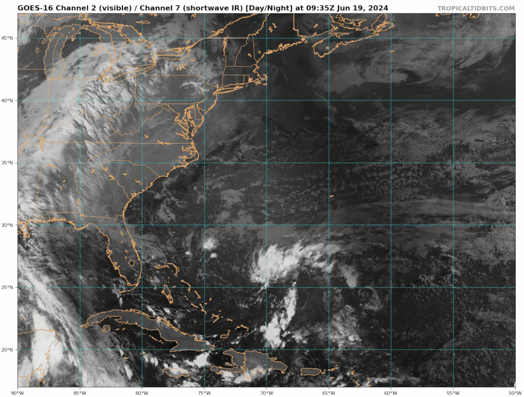
Lots of deep convection firing North of Puerto Rico. Looks like it is just to the SW of a broad area of vorticity, although hard to tell on visible where exactly that vorticity is centered at
0 likes
B.S. Meteorology from Florida State '24 // Current M.S. Meteorology student at Florida State
Research Interests: Rapid Intensification, TC Climatology, TC Modeling
Consult the NHC for official information
Research Interests: Rapid Intensification, TC Climatology, TC Modeling
Consult the NHC for official information
-
cycloneye
- Admin
- Posts: 149260
- Age: 69
- Joined: Thu Oct 10, 2002 10:54 am
- Location: San Juan, Puerto Rico
Re: Surface trough east of the Bahamas (10/20)
1 likes
Visit the Caribbean-Central America Weather Thread where you can find at first post web cams,radars
and observations from Caribbean basin members Click Here
and observations from Caribbean basin members Click Here
-
cycloneye
- Admin
- Posts: 149260
- Age: 69
- Joined: Thu Oct 10, 2002 10:54 am
- Location: San Juan, Puerto Rico
Re: Surface trough east of the Bahamas (10/20)
8 PM:
Southwestern Atlantic Ocean:
An area of showers and thunderstorms located several hundred miles
east of the Bahamas is associated with a surface trough and an
upper-level area of low pressure. Environmental conditions are
marginally conducive for some gradual development of this system
during the next few days while it moves westward or
west-northwestward. The system is forecast to approach the coast of
the southeastern United States on Thursday.
* Formation chance through 48 hours...low...10 percent.
* Formation chance through 7 days...low...20 percent.
0 likes
Visit the Caribbean-Central America Weather Thread where you can find at first post web cams,radars
and observations from Caribbean basin members Click Here
and observations from Caribbean basin members Click Here
-
otowntiger
- Category 5

- Posts: 1932
- Joined: Tue Aug 31, 2004 7:06 pm
Re: Surface trough east of the Bahamas (10/20)
What is a lot more noteworthy than the breeze are the nice temps for this time of year! Very pleasant and amazing for late June around these parts!
1 likes
-
Blown Away

- S2K Supporter
- Posts: 10253
- Joined: Wed May 26, 2004 6:17 am
Re: Surface trough east of the Bahamas (10/20)
Swirl @25/70 moving towards the coast. Conditions in the basin not quite there, but I think we are a few weeks away from lift off in the basin. I’m ready!!!
0 likes
Hurricane Eye Experience: David 79, Irene 99, Frances 04, Jeanne 04, Wilma 05… Hurricane Brush Experience: Andrew 92, Erin 95, Floyd 99, Matthew 16, Irma 17, Ian 22, Nicole 22…
-
cycloneye
- Admin
- Posts: 149260
- Age: 69
- Joined: Thu Oct 10, 2002 10:54 am
- Location: San Juan, Puerto Rico
Re: Surface trough east of the Bahamas (10/20)
1 likes
Visit the Caribbean-Central America Weather Thread where you can find at first post web cams,radars
and observations from Caribbean basin members Click Here
and observations from Caribbean basin members Click Here
-
cycloneye
- Admin
- Posts: 149260
- Age: 69
- Joined: Thu Oct 10, 2002 10:54 am
- Location: San Juan, Puerto Rico
Re: Surface trough east of the Bahamas (20/20)
2 PM:
Southwestern Atlantic Ocean:
An area of showers and thunderstorms located a few hundred miles
east of the Bahamas is associated with a surface trough of low
pressure. Environmental conditions are marginally conducive for some
gradual development of this system during the next few days while it
moves westward or west-northwestward. The system is forecast to
approach the coast of the southeastern United States by Friday.
* Formation chance through 48 hours...low...20 percent.
* Formation chance through 7 days...low...20 percent.
0 likes
Visit the Caribbean-Central America Weather Thread where you can find at first post web cams,radars
and observations from Caribbean basin members Click Here
and observations from Caribbean basin members Click Here
-
Blown Away
- S2K Supporter
- Posts: 10253
- Joined: Wed May 26, 2004 6:17 am
Re: Surface trough east of the Bahamas (20/20)
Be nice if they would invest tag this area…
1 likes
Hurricane Eye Experience: David 79, Irene 99, Frances 04, Jeanne 04, Wilma 05… Hurricane Brush Experience: Andrew 92, Erin 95, Floyd 99, Matthew 16, Irma 17, Ian 22, Nicole 22…
-
Sciencerocks
- Category 5
- Posts: 10181
- Age: 40
- Joined: Thu Jul 06, 2017 1:51 am
-
AJC3
- Admin
- Posts: 4153
- Age: 62
- Joined: Tue Aug 31, 2004 7:04 pm
- Location: Ballston Spa, New York
- Contact:
Re: Surface trough east of the Bahamas (20/20)
Blown Away wrote:Be nice if they would invest tag this area…
Looks like your wish was granted...
This is now INVEST 92L
4 likes
Who is online
Users browsing this forum: No registered users and 139 guests