This is the general tropical discussion area. Anyone can take their shot at predicting a storms path.
Moderator: S2k Moderators
Forum rules
The posts in this forum are NOT official forecasts and should not be used as such. They are just the opinion of the poster and may or may not be backed by sound meteorological data. They are NOT endorsed by any professional institution or
STORM2K. For official information, please refer to products from the
National Hurricane Center and
National Weather Service.
-
cycloneye
- Admin

- Posts: 146465
- Age: 69
- Joined: Thu Oct 10, 2002 10:54 am
- Location: San Juan, Puerto Rico
#281 Postby cycloneye » Thu Jul 31, 2025 6:44 am
Central East Pacific:
An area of low pressure is expected to form well south of
southwestern Mexico in the next couple of days. Environmental
conditions appear conducive for some gradual development of this
system, and a tropical depression is likely to form over the
weekend or early next week as the system moves west-northwestward at
10 to 15 mph.
* Formation chance through 48 hours...low...near 0 percent.
* Formation chance through 7 days...high...70 percent.
0 likes
Visit the Caribbean-Central America Weather Thread where you can find at first post web cams,radars
and observations from Caribbean basin members
Click Here
-
cycloneye
- Admin
- Posts: 146465
- Age: 69
- Joined: Thu Oct 10, 2002 10:54 am
- Location: San Juan, Puerto Rico
#282 Postby cycloneye » Fri Aug 01, 2025 8:32 am
2. Central East Pacific:
An area of low pressure is expected to form well southwest of
southwestern Mexico within the next day or two. Environmental
conditions appear conducive for some gradual development of this
system, and a tropical depression is likely to form late this
weekend or early next week as the system moves west-northwestward at
10 to 15 mph.
* Formation chance through 48 hours...low...30 percent.
* Formation chance through 7 days...high...80 percent.
3. South of Southern Mexico:
An area of low pressure is forecast to form offshore of the coast of
Central America and southern Mexico by the middle part of next week.
Thereafter, environmental conditions appear conducive for some
development as the system moves generally west-northwestward at 10
to 15 mph.
* Formation chance through 48 hours...low...near 0 percent.
* Formation chance through 7 days...low...20 percent.
0 likes
Visit the Caribbean-Central America Weather Thread where you can find at first post web cams,radars
and observations from Caribbean basin members
Click Here
-
cycloneye
- Admin
- Posts: 146465
- Age: 69
- Joined: Thu Oct 10, 2002 10:54 am
- Location: San Juan, Puerto Rico
#283 Postby cycloneye » Fri Aug 01, 2025 6:46 pm
1. Central East Pacific:
An area of low pressure is expected to form well southwest of
southwestern Mexico within the next day or two. Environmental
conditions appear conducive for some gradual development of this
system, and a tropical depression is likely to form late this
weekend or early next week as the system moves west-northwestward at
10 to 15 mph.
* Formation chance through 48 hours...medium...40 percent.
* Formation chance through 7 days...high...80 percent.
2. South of Southern Mexico:
An area of low pressure is forecast to form offshore of the coast of
Central America and southern Mexico by the middle part of next week.
Thereafter, environmental conditions appear conducive for some
development as the system moves generally west-northwestward at 10
to 15 mph.
* Formation chance through 48 hours...low...near 0 percent.
* Formation chance through 7 days...low...30 percent.
0 likes
Visit the Caribbean-Central America Weather Thread where you can find at first post web cams,radars
and observations from Caribbean basin members
Click Here
-
Kingarabian
- S2K Supporter

- Posts: 16161
- Joined: Sat Aug 08, 2009 3:06 am
- Location: Honolulu, Hawaii
#284 Postby Kingarabian » Sat Aug 02, 2025 3:28 pm
Still below normal ACE.
0 likes
RIP Kobe Bryant
-
Astromanía
- Category 2

- Posts: 781
- Age: 26
- Joined: Sat Aug 25, 2018 10:34 pm
- Location: Monterrey, N.L, México
#285 Postby Astromanía » Sat Aug 02, 2025 8:15 pm
I mean it's very obvious why, but at least EPAC is doing some decent action
3 likes
-
cycloneye
- Admin
- Posts: 146465
- Age: 69
- Joined: Thu Oct 10, 2002 10:54 am
- Location: San Juan, Puerto Rico
#286 Postby cycloneye » Mon Aug 04, 2025 6:37 pm
South of Southern Mexico:
An area of low pressure just offshore of the coast of Central
America is producing a large area of disorganized showers and
thunderstorms. Environmental conditions appear conducive for
development of this system, and a tropical depression is likely to
form later this week while the system moves west-northwestward
around 15 mph.
* Formation chance through 48 hours...low...30 percent.
* Formation chance through 7 days...high...80 percent.
1 likes
Visit the Caribbean-Central America Weather Thread where you can find at first post web cams,radars
and observations from Caribbean basin members
Click Here
-
cycloneye
- Admin
- Posts: 146465
- Age: 69
- Joined: Thu Oct 10, 2002 10:54 am
- Location: San Juan, Puerto Rico
#287 Postby cycloneye » Thu Aug 21, 2025 12:36 pm
Finnally, the basin looks to wake up.
Tropical Weather Outlook
NWS National Hurricane Center Miami FL
1100 AM PDT Thu Aug 21 2025
For the eastern and central North Pacific east of 180 longitude:
1. South of Southwestern Mexico:
An area of low pressure is likely to form this weekend off the coast
of southwestern Mexico. Environmental conditions appear conducive
for some gradual development of this system, and a tropical
depression could form during the early or middle portions of next
week while it moves generally west-northwestward at 10 to 15 mph
well off the coast of Mexico.
* Formation chance through 48 hours...low...near 0 percent.
* Formation chance through 7 days...medium...40 percent.
Forecaster Cangialosi

0 likes
Visit the Caribbean-Central America Weather Thread where you can find at first post web cams,radars
and observations from Caribbean basin members
Click Here
-
Kingarabian
- S2K Supporter
- Posts: 16161
- Joined: Sat Aug 08, 2009 3:06 am
- Location: Honolulu, Hawaii
#288 Postby Kingarabian » Sun Aug 24, 2025 8:19 pm
18z GFS had 4 systems.
0 likes
RIP Kobe Bryant
-
cycloneye
- Admin
- Posts: 146465
- Age: 69
- Joined: Thu Oct 10, 2002 10:54 am
- Location: San Juan, Puerto Rico
#289 Postby cycloneye » Tue Aug 26, 2025 6:31 am
Tropical Weather Outlook
NWS National Hurricane Center Miami FL
500 AM PDT Tue Aug 26 2025
South of Southern Mexico:
An area of low pressure could form this weekend offshore of the
coast of Central America and southern Mexico. Environmental
conditions appear conducive for some gradual development of this
system early next week while it moves generally west-northwestward
at 10 to 15 mph.
* Formation chance through 48 hours...low...near 0 percent.
* Formation chance through 7 days...low...20 percent.
0 likes
Visit the Caribbean-Central America Weather Thread where you can find at first post web cams,radars
and observations from Caribbean basin members
Click Here
-
cycloneye
- Admin
- Posts: 146465
- Age: 69
- Joined: Thu Oct 10, 2002 10:54 am
- Location: San Juan, Puerto Rico
#290 Postby cycloneye » Tue Aug 26, 2025 6:43 am
Looks like this basin will be very active in the next couple of weeks.

0 likes
Visit the Caribbean-Central America Weather Thread where you can find at first post web cams,radars
and observations from Caribbean basin members
Click Here
-
Kingarabian
- S2K Supporter
- Posts: 16161
- Joined: Sat Aug 08, 2009 3:06 am
- Location: Honolulu, Hawaii
#291 Postby Kingarabian » Tue Aug 26, 2025 7:28 am
Potential for a basin crosser as well.

0 likes
RIP Kobe Bryant
-
DorkyMcDorkface
- Category 4

- Posts: 919
- Age: 27
- Joined: Mon Sep 30, 2019 1:32 pm
- Location: Mid-Atlantic
#292 Postby DorkyMcDorkface » Thu Aug 28, 2025 8:33 am
This has since been fixed, but I thought I share this little glitch I caught on the TWO this morning

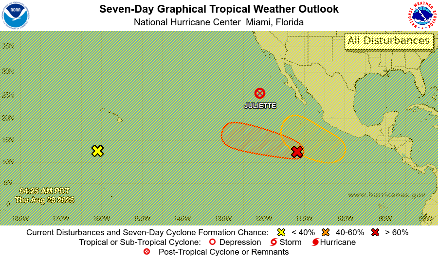
3 likes
Please note the thougths expressed by this account are solely those of the user and are from a hobbyist perspective. For more comprehensive analysis, consult an actual professional meteorologist or meteorology agency.
Floyd 1999 |
Isabel 2003 |
Hanna 2008 |
Irene 2011 |
Sandy 2012 |
Isaias 2020
-
cycloneye
- Admin
- Posts: 146465
- Age: 69
- Joined: Thu Oct 10, 2002 10:54 am
- Location: San Juan, Puerto Rico
#293 Postby cycloneye » Thu Aug 28, 2025 9:23 am
It will be interesting to see how the upcomming basin outbreak affects the NATL. I guess it depends on how active it is to impart the shear from the outflows to the Caribbean.
0 likes
Visit the Caribbean-Central America Weather Thread where you can find at first post web cams,radars
and observations from Caribbean basin members
Click Here
-
Kingarabian
- S2K Supporter
- Posts: 16161
- Joined: Sat Aug 08, 2009 3:06 am
- Location: Honolulu, Hawaii
#294 Postby Kingarabian » Tue Sep 02, 2025 1:27 pm
cycloneye wrote:It will be interesting to see how the upcomming basin outbreak affects the NATL. I guess it depends on how active it is to impart the shear from the outflows to the Caribbean.
GOM and WCaribbean will be temporarily closed for business while Lorena is still churning. Look how large it is.
5 likes
RIP Kobe Bryant
-
Ntxw
- Storm2k Moderator

- Posts: 22809
- Joined: Wed Oct 21, 2009 6:34 pm
- Location: DFW, Texas
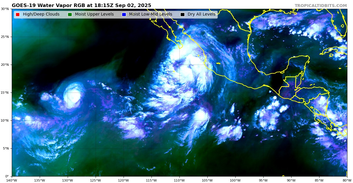
#295 Postby Ntxw » Wed Sep 03, 2025 10:48 am
What a busy few days for the EPAC. Lorena threatening Mexico, potential flooding in the SW US and Kiko southeast of Hawaii bombing out.

4 likes
The above post and any post by Ntxw is NOT an official forecast and should not be used as such. It is just the opinion of the poster and may or may not be backed by sound meteorological data. It is NOT endorsed by any professional institution including Storm2k. For official information, please refer to NWS products.
Help support Storm2K!

-
Teban54
- Category 5

- Posts: 3279
- Joined: Sat May 19, 2018 1:19 pm
#296 Postby Teban54 » Wed Sep 03, 2025 11:10 am
Ntxw wrote:What a busy few days for the EPAC. Lorena threatening Mexico, potential flooding in the SW US and Kiko southeast of Hawaii bombing out.
https://i.ibb.co/Q3nxBfFd/epac.jpg
Lorena is also likely bombing out as we speak.
1 likes
-
StormWeather
- Category 1

- Posts: 332
- Joined: Wed Jun 05, 2024 2:34 pm
#297 Postby StormWeather » Wed Sep 03, 2025 11:13 am
Teban54 wrote:Ntxw wrote:What a busy few days for the EPAC. Lorena threatening Mexico, potential flooding in the SW US and Kiko southeast of Hawaii bombing out.
https://i.ibb.co/Q3nxBfFd/epac.jpg
Lorena is also likely bombing out as we speak.
Definitely a 180 from last year. We were at the letter “H” at this time last year.
0 likes
Just an average cyclone tracker
The posts in this forum are NOT official forecasts and should not be used as such. They are just the opinion of the poster and may or may not be backed by sound meteorological data. They are NOT endorsed by any professional institution or storm2k.org. For official information, please refer to the NHC and NWS products
Return to “Talkin' Tropics”
Who is online
Users browsing this forum: Google [Bot], Gums, hipshot, HurricaneFan, Kazmit, MarioProtVI, ouragans, Pelicane, pepecool20, Stratton23, StrongWind, TheBurn, Ulf, WaveBreaking and 233 guests


