
Latest EMC ENSO projections for the next 10 months.
Moderator: S2k Moderators
Forum rules

The posts in this forum are NOT official forecasts and should not be used as such. They are just the opinion of the poster and may or may not be backed by sound meteorological data. They are NOT endorsed by any professional institution or STORM2K. For official information, please refer to products from the National Hurricane Center and National Weather Service.
-
Stormsfury

- Category 5

- Posts: 10549
- Age: 53
- Joined: Wed Feb 05, 2003 6:27 pm
- Location: Summerville, SC
Latest EMC ENSO projections for the next 10 months.
After a cooling period, EMC projections begin to increase the SST anomalies across the Equatorial Pacific again towards the Summer of 2004.
0 likes
-
hurricanetrack

- HurricaneTrack.com
- Posts: 1781
- Joined: Tue Dec 02, 2003 10:46 pm
- Location: Wilmington, NC
- Contact:
I wonder why though
These graphics and models that show an El Nino coming next summer are good at displaying what some computer models "think". But my question is: why? Why will the atmosphere change in such a way so that the Pacific warms up to above normal? When folks can nail that one, then we'll really be on to something.
The reason I ask is because I thought El Ninos were supposed to be 3 to 5 years apart (or something like that). We had one in 2002- so the next one should not be due until at least 2005, right?
Plus- the SOI for the past 30 and 90 days is now positive. I do not know what this means in the scheme of things, but from what I understand, negative SOI= El Nino and positive SOI=La Nina.
We shall see... this is what makes it all so fun!
0 likes
-
Stormsfury
- Category 5
- Posts: 10549
- Age: 53
- Joined: Wed Feb 05, 2003 6:27 pm
- Location: Summerville, SC
Re: I wonder why though
hurricanetrack wrote:These graphics and models that show an El Nino coming next summer are good at displaying what some computer models "think". But my question is: why? Why will the atmosphere change in such a way so that the Pacific warms up to above normal? When folks can nail that one, then we'll really be on to something.
The reason I ask is because I thought El Ninos were supposed to be 3 to 5 years apart (or something like that). We had one in 2002- so the next one should not be due until at least 2005, right?
Plus- the SOI for the past 30 and 90 days is now positive. I do not know what this means in the scheme of things, but from what I understand, negative SOI= El Nino and positive SOI=La Nina.
We shall see... this is what makes it all so fun!
Multi-Decadal phases of the Pacific (and Atlantic) for that matter make up the ground work for more or less periods of Equatorial warming in the Pacific. During a PDO (Pacific Decadal Oscillation) that enters a cool phase, there's more likelihood that the pattern is dominated primarily but cooler equatorial SST's as the Northern Pacific Waters go warm. The current phase of the PDO would generally support neutral to cool episodes as evidenced, but there's a lot of variability and doesn't mean that we can't get a period of warm SST's anomalies even during a cool phase of the PDO or vice-versa.

Read more here about the PDO here ..
http://tao.atmos.washington.edu/pdo/
As for the SOI (Southern Oscillation Index) ... prolonged periods of POS values would generally indicate that La Niña conditions would exist. However, the recent surge of the SOI going way positive was attributed to a TC in that region. However and this is NOT documented but it's a general idea that the pattern which produces bursts of POSITIVE SOI values may be the same that lead to blocking across the world.
Generally, it's been just hovering slightly negative until this recent burst.
http://www.longpaddock.qld.gov.au/Seaso ... SOIValues/
You can see the 90 day average just went positive, and the 30 day average is now over 10. The overall average this year has been slightly neg. as seen here (as you've pointed out). The weird thing is that the upcoming progged pattern resembles a La Niña somewhat ... a SE ridge, very cold air in NW Canada, etc.
http://www.longpaddock.qld.gov.au/Seaso ... index.html
A running 3 year tally, graphically ...
http://www.longpaddock.qld.gov.au/Seaso ... index.html
This is a historical look at the SOI since 1876.
http://www.bom.gov.au/climate/current/soihtm1.shtml
And if you need SST information that site is also a good place to start as well ... in fact, my page located ...
http://www.stormsfury1.com/Weather/Floo ... alies.html
may also be a good place to start as well ...
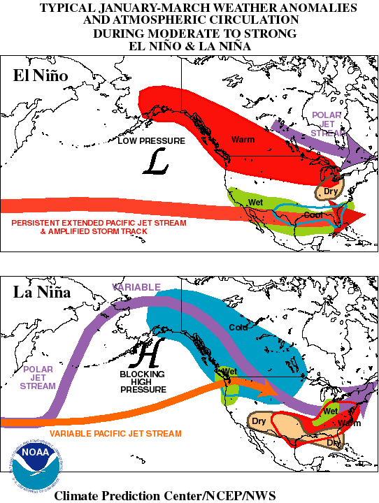
Now compare the La Niña pattern map to the EURO Day 7 (12/24/03) SFC plot and the Day 8-10 3 day average. Blocking signatures?


SF
0 likes
-
Stormsfury
- Category 5
- Posts: 10549
- Age: 53
- Joined: Wed Feb 05, 2003 6:27 pm
- Location: Summerville, SC
Recent trends in the EQ PAC have showed cooling of the anomalies, however, this may be short-lived as the depth of the waters have been showing some warming again, especially close to SA. But with cool patches developing in the WPAC.
ftp://ftpprd.ncep.noaa.gov/pub/cpc/wd52 ... kxzteq.gif
ftp://ftpprd.ncep.noaa.gov/pub/cpc/wd52 ... kxzteq.gif
0 likes
-
FLguy

- Professional-Met

- Posts: 799
- Joined: Mon Dec 29, 2003 5:36 pm
- Location: Daytona Beach FL
- Contact:
Stormsfury wrote:Recent trends in the EQ PAC have showed cooling of the anomalies, however, this may be short-lived as the depth of the waters have been showing some warming again, especially close to SA. But with cool patches developing in the WPAC.
ftp://ftpprd.ncep.noaa.gov/pub/cpc/wd52 ... kxzteq.gif
The long term cycles in the alantic and pacific regulate TC formation in both basins in decadal and multi-decadal time steps.
Short term functions of the ATC (atlantic thermohaline circulation) and PDO (Pacific decadal oscillation) are manifested in the short term swings in the higher frequency NAO in the Atlantic and ENSO in the pacific.
A negative swing in the NAO index during the tropical season can be the precursor to a surge in TC development in the atlantic basin.
Since the long term warm and cold cycles in the atlantic and pacific normally go hand in hand...the decadal TC formaton tendencies in the atlantic and pacific normally will reflect the state of those two features.
A strong ATC and Negative (cold Phase) PDO would indicate a decadal trend for increased atlantic activity and decreased pacific activity
the same as a weak ATC and Positive (warm phase) PDO would argue for increased pacific activity and decreased TC formation in the atlantic basin. keep in mind these are long term trends...short term (season-to-season) variations in activity are common based on shorter term fluctuations in the ATC and PDO.
At the present time the Atlantic and paciifc are in the long term cold cycles --- strong ATC and cold phase PDO. El Nino events of weak or moderate intensity in the long-term PDO cycle tend to have less of an effect on mitigating atlantic TC activity. Especially depending on the QBO phase and the short-term state of the ATC.
Warm water in the far north atlantic and tropical atlantic with a cold wedge in the middle normally imply a strong ATC on short term scale. The reason why the strong cycle ATC favor TC formation is due to the fact that there is a more even distribution of heat between the pole and the tropics...not to mention that the atlantic is warmer than normal overall. the ATC will alos regulate the favored phase of the NAo during the tropical season.
Weak ATC ----- tendency for a Positive NAO
Strong ATC ----- tendency for a Negative NAO
the same goes for the PDO.
Cold phase PDO ---- More frequent La nina events. Fewer/weaker El Nino/s
Warm Phase PDO ---- More frequent El Nino events. fewer/weaker la nina episodes.
In the weak ATC cycle the equatorial regions are warmer relative to normal and the polar region is cooler. a strong ATC will attempt to lessen the thermal contrast between the two regions as heat is distributed more evenly.
BTW...great series of posts SF and well written too...
0 likes
Who is online
Users browsing this forum: gib, Hurricanehink, wwizard and 100 guests