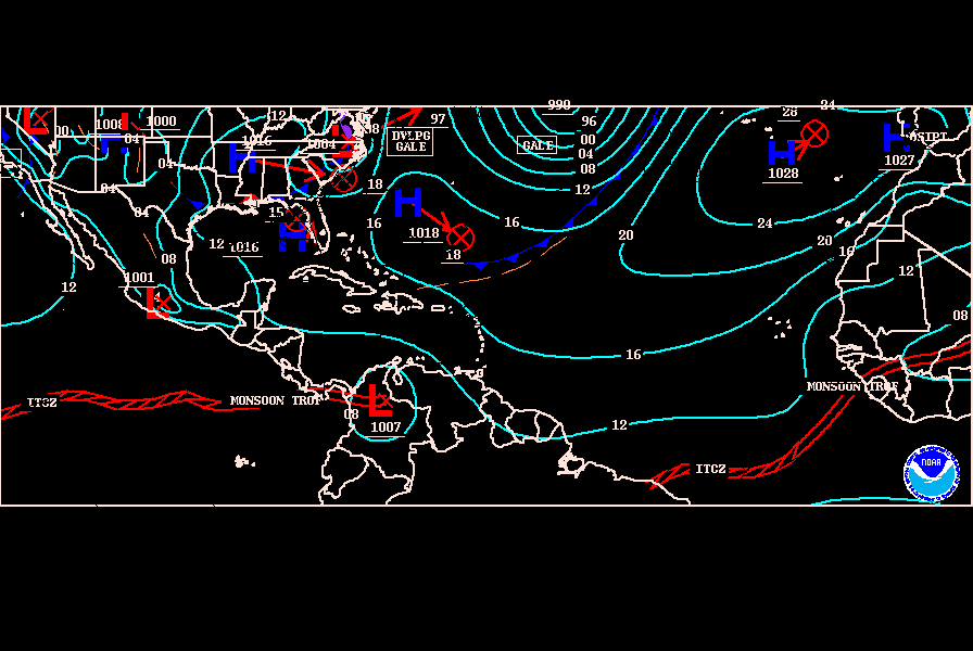
Surprising! Tropical Low forms in the Central Atlantic

This is the general tropical discussion area. Anyone can take their shot at predicting a storms path.

Moderator: S2k Moderators

Forum rules

The posts in this forum are NOT official forecasts and should not be used as such. They are just the opinion of the poster and may or may not be backed by sound meteorological data. They are NOT endorsed by any professional institution or STORM2K. For official information, please refer to products from the National Hurricane Center and National Weather Service.

Help Support Storm2K
Message
Author
User avatar
HURAKAN
Professional-Met
Professional-Met
Posts: 46086
Age: 38
Joined: Thu May 20, 2004 4:34 pm
Location: Key West, FL
Contact:

Surprising! Tropical Low forms in the Central Atlantic

#1 Postby HURAKAN » Sun Jun 13, 2004 10:17 pm

Although the tropical wave is very disorganized, convectively speaking, it has managed someway to develop a low level circulation. The low is very weak, 1014 MB, and I believe it would dissipate before crossing the Lesser Antilles due to unfavorable upper level winds. But still it is interesting!

Image

Image

Image
0 likes   

Josephine96

#2 Postby Josephine96 » Sun Jun 13, 2004 10:37 pm

Hmm.. Fish depression? lol
0 likes   

ColdFront77

#3 Postby ColdFront77 » Sun Jun 13, 2004 10:42 pm

No one has mentioned the swirl, now north of the Yucatan. It deserves a mention, no matter what it does... it's associated with this system, after all.
0 likes   

Josephine96

#4 Postby Josephine96 » Sun Jun 13, 2004 10:53 pm

Hey Tom.. I don't even think I've seen a drop of rain.. your avatar seems deceiving lol
0 likes   

MWatkins
S2K Supporter
S2K Supporter
Posts: 2574
Joined: Sat Oct 12, 2002 7:51 pm
Location: SE Florida
Contact:

#5 Postby MWatkins » Sun Jun 13, 2004 10:55 pm

ColdFront77 wrote:No one has mentioned the swirl, now north of the Yucatan. It deserves a mention, no matter what it does... it's associated with this system, after all.


Hey CF...looks to me to be yet another vorticy center embedded in a much larger...broader and disorganized area of low pressure. Now...if this swirl starts to push up some thunderstorms on it's own...the environment down there would be a little more favorable than further to the NW/W.

14 hour old QSCAT imagery shows mostly easterly winds down there...

http://manati.wwb.noaa.gov/storm_at_ima ... _at_0.html

Can't post the link cause it's too long...but a 4 hour old SSM/I pass didn't suggest anything going on in 37H imagery.

But it's a feature to keep an eye on.

MW
0 likes   

User avatar
abajan
S2K Supporter
S2K Supporter
Posts: 4305
Age: 61
Joined: Sun Sep 07, 2003 5:10 am
Location: Barbados

#6 Postby abajan » Mon Jun 14, 2004 4:09 am

Since Hurricane Lenny a few years ago, almost nothing surprises me about the weather.
0 likes   

Steve H.
Category 5
Category 5
Posts: 2163
Joined: Sat Oct 19, 2002 9:06 am
Location: Palm Bay, Florida

#7 Postby Steve H. » Mon Jun 14, 2004 8:53 am

Why are my posts getting deleted admin?
0 likes   

chadtm80

#8 Postby chadtm80 » Mon Jun 14, 2004 8:55 am

What posts where deleted Steve? First im hearing of it
0 likes   

User avatar
cycloneye
Admin
Admin
Posts: 148496
Age: 69
Joined: Thu Oct 10, 2002 10:54 am
Location: San Juan, Puerto Rico

#9 Postby cycloneye » Mon Jun 14, 2004 9:00 am

Yes Steve to me too first time I hear about it.Which ones you say were deleited?
0 likes   
Visit the Caribbean-Central America Weather Thread where you can find at first post web cams,radars
and observations from Caribbean basin members Click Here

Matthew5

#10 Postby Matthew5 » Mon Jun 14, 2004 9:01 am

Looks good tihs morning maybe something to watch :eek:
0 likes   

User avatar
HURAKAN
Professional-Met
Professional-Met
Posts: 46086
Age: 38
Joined: Thu May 20, 2004 4:34 pm
Location: Key West, FL
Contact:

#11 Postby HURAKAN » Mon Jun 14, 2004 9:11 am

Today the wave looks better than yesterday but still I don't think nothing more will happen, maybe when the wave reaches the Western Caribbean the story will be different if the shear remains in check.
0 likes   

User avatar
Wnghs2007
Category 5
Category 5
Posts: 6836
Age: 36
Joined: Wed Mar 24, 2004 11:14 pm
Location: Gwinnett-Barrow Line; Georgia
Contact:

#12 Postby Wnghs2007 » Mon Jun 14, 2004 9:12 am

The pressure has lowered to 1013 mb but that is still high. Atleast its something to look at while we wait for the real CV season to start in a month and a half or so!!!:D
0 likes   

User avatar
HURAKAN
Professional-Met
Professional-Met
Posts: 46086
Age: 38
Joined: Thu May 20, 2004 4:34 pm
Location: Key West, FL
Contact:

#13 Postby HURAKAN » Mon Jun 14, 2004 9:15 am

Wnghs2007 wrote:The pressure has lowered to 1013 mb but that is still high. Atleast its something to look at while we wait for the real CV season to start in a month and a half or so!!!:D


The pressure is still high but interestingly to say, you remember Josephine in 2002, when the NHC gave out the fist advisory the pressure was around 1015 mb.
0 likes   

User avatar
Wnghs2007
Category 5
Category 5
Posts: 6836
Age: 36
Joined: Wed Mar 24, 2004 11:14 pm
Location: Gwinnett-Barrow Line; Georgia
Contact:

#14 Postby Wnghs2007 » Mon Jun 14, 2004 9:18 am

HURAKAN wrote:
Wnghs2007 wrote:The pressure has lowered to 1013 mb but that is still high. Atleast its something to look at while we wait for the real CV season to start in a month and a half or so!!!:D


The pressure is still high but interestingly to say, you remember Josephine in 2002, when the NHC gave out the fist advisory the pressure was around 1015 mb.


Heck think of Danny that formed last year. When it was first made a Tropical Depression, Surface pressure was 1017 mb!!!! :eek: :eek: :eek: 8-)
0 likes   

User avatar
HURAKAN
Professional-Met
Professional-Met
Posts: 46086
Age: 38
Joined: Thu May 20, 2004 4:34 pm
Location: Key West, FL
Contact:

#15 Postby HURAKAN » Mon Jun 14, 2004 9:28 am

Wnghs2007 wrote:
HURAKAN wrote:
Wnghs2007 wrote:The pressure has lowered to 1013 mb but that is still high. Atleast its something to look at while we wait for the real CV season to start in a month and a half or so!!!:D


The pressure is still high but interestingly to say, you remember Josephine in 2002, when the NHC gave out the fist advisory the pressure was around 1015 mb.


Heck think of Danny that formed last year. When it was first made a Tropical Depression, Surface pressure was 1017 mb!!!! :eek: :eek: :eek: 8-)


ANOTHER GOOD EXAMPLE!!! :)
0 likes   

User avatar
HURAKAN
Professional-Met
Professional-Met
Posts: 46086
Age: 38
Joined: Thu May 20, 2004 4:34 pm
Location: Key West, FL
Contact:

#16 Postby HURAKAN » Mon Jun 14, 2004 10:42 am

According to what I can see in the image below the cluster of convection related to the weak low level circulation attached to the tropical wouldn't last very long since it is getting near to very strong upper level shear. It's clearly visible by the curvature of the clouds in front of the wave.

Image
0 likes   

Steve H.
Category 5
Category 5
Posts: 2163
Joined: Sat Oct 19, 2002 9:06 am
Location: Palm Bay, Florida

#17 Postby Steve H. » Mon Jun 14, 2004 11:15 am

Well, I posted on this wave yesterday and today, today under this thread and I can't find it. But regardless, 1013mb isn't what I would call High pressure, and it certainly must be taken as relative to surrounding pressures, as was the case with storms mentioned above. The shear ahead of it MAY lift out as low pressure in the central atlantic moves to the NNE with the associated front. I like this wave, even though it is a bit early. Let's see if a ridge can build where the low/trough is exiting from. This is moving past 50W, and would only be about two weeks early for development that comes from this area (this is near where Bertha formed). Something to watch anyhow!
0 likes   


Return to “Talkin' Tropics”

Who is online

Users browsing this forum: Google [Bot], kevin and 46 guests