The waiting game may be ending

This is the general tropical discussion area. Anyone can take their shot at predicting a storms path.

Moderator: S2k Moderators

Forum rules

The posts in this forum are NOT official forecasts and should not be used as such. They are just the opinion of the poster and may or may not be backed by sound meteorological data. They are NOT endorsed by any professional institution or STORM2K. For official information, please refer to products from the National Hurricane Center and National Weather Service.

Help Support Storm2K
Message
Author
User avatar
The_Cycloman_PR
Category 1
Category 1
Posts: 316
Joined: Mon Oct 28, 2002 12:10 pm
Location: Puerto Rico

The waiting game may be ending

#1 Postby The_Cycloman_PR » Mon Jul 19, 2004 10:42 am

As time goes on in 2004-05 Atlantic basin hurricane season and some of us become a little anxious to see something to track outhere, June and almost July has passed without anything interesting to observe. The words "boring", "dead season", and some thoughs about "if this season is really going to be active or not" have grown in our minds. Also the word "patience" and some of the PROs from the board saying that statistically June and July are slow weather activity months and that the action may begin in August and September, had appeared on the board. The traditional post "Remember 1998, when the first tropical storm of the season formed late July and we had George and Mitch and 14 systems formed" had been posted several times. Some other statistic of late seasons also had been posted to calm our anxious "hurricane entusiast" hearts.

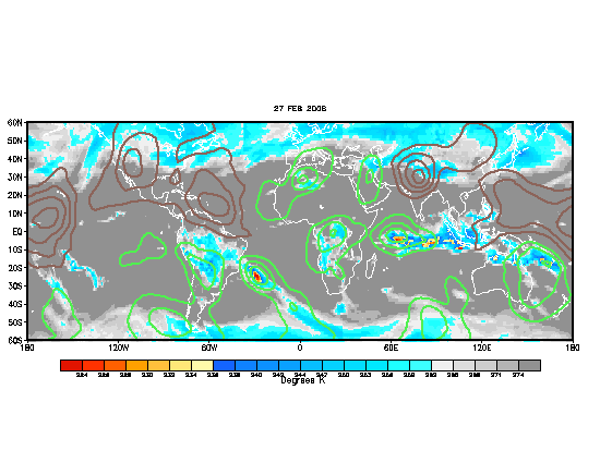
As time goes on the season has been quiet but the board has been active. I think the waiting game is almost over!! With the MJO now in the Atlantic, we can see that it's effects are now taking place in the E-pac that quickly became more active with 4 tropical depressions and 2 tropical storms. (**Please scroll down to see the entire topic**)
Image

As we have the MJO in the Atlantic for a couple of weeks right now the effects have started to appear with better climate conditions and an increase of strong tropical waves in the Atlantic basin (Including the one we are looking right now in the 50-60Ws and the just emerged from Africa one)

The Atlantic SST'S are now in place for Tropical Activity as the 80f+ degrees reached the African coast over the entire Atlantic basin.

http://www.weather.com/maps/news/julynonactive/atlanticoceanseasurfacetemps_large.html


And also the SAL has disipated the most leaving the area with less subsidence and better conditions for development.

Image
Image


I'm not going to jump into any guess or forecast for the wave near the islands or the african one, leaving that for the experts from Storm2k but I can say that we are now entering in a more favorable environment that may speed up the season making this a more active one during the next 2 or 3 months. I think from this week on we will begin to see more stronger waves emerging from Africa and I will not be sorprised if we see Alex forming somewhere there (Gulf, Caribbean, east of the islands, or somewhere else) soon.

With next MJO in the Atlantic just the same time of the Peak season (From late August until mid September) we will have "Full hands" during during the season peak. So use our present "dead time" to update your emergency plans and make your corrections to your home and everything else. Now is the time.

The truth is...The waiting game is almost over.

Cycloman
0 likes   

User avatar
Hurricanehink
S2K Supporter
S2K Supporter
Posts: 2044
Joined: Sun Nov 16, 2003 2:05 pm
Location: New Jersey

#2 Postby Hurricanehink » Mon Jul 19, 2004 10:59 am

Good cover of the current suitation. I think you may be right. The waiting game sucks, and it may be ending.
0 likes   

Anonymous

#3 Postby Anonymous » Mon Jul 19, 2004 11:11 am

Yes, we have to watch...
0 likes   

User avatar
HURAKAN
Professional-Met
Professional-Met
Posts: 46086
Age: 38
Joined: Thu May 20, 2004 4:34 pm
Location: Key West, FL
Contact:

#4 Postby HURAKAN » Mon Jul 19, 2004 11:17 am

Image

At least Shear in the Caribbean Sea doesn't look to be a problem at all.
0 likes   

User avatar
lilbump3000
Category 4
Category 4
Posts: 966
Age: 38
Joined: Sat Sep 20, 2003 10:09 am
Location: New Orleans, Louisiana
Contact:

#5 Postby lilbump3000 » Mon Jul 19, 2004 11:19 am

To me this system seems that it will not be long before being upgraded to a tropical depression.

Look at the visible loop below and when its finish loading set the speed thing in the middle and see what you think about the wave.

http://www.ssd.noaa.gov/PS/TROP/DATA/RT/watl-vis-loop.html
0 likes   

Stormchaser16
Category 5
Category 5
Posts: 1013
Joined: Thu Aug 21, 2003 10:25 pm
Location: NW Jersey
Contact:

#6 Postby Stormchaser16 » Mon Jul 19, 2004 11:22 am

Ehhhh not even close to me....

Absolutely NO surface rotation
Moving too fast to close off W wind
Dry air out ahead of it
0 likes   

User avatar
HURAKAN
Professional-Met
Professional-Met
Posts: 46086
Age: 38
Joined: Thu May 20, 2004 4:34 pm
Location: Key West, FL
Contact:

#7 Postby HURAKAN » Mon Jul 19, 2004 11:51 am

Stormchaser16 wrote:Ehhhh not even close to me....

Absolutely NO surface rotation
Moving too fast to close off W wind
Dry air out ahead of it


WELL, I KNOW, NOT A GOOD RECIPE FOR TROPICAL FORMATION.
0 likes   

User avatar
KatDaddy
Category 5
Category 5
Posts: 2815
Joined: Mon Oct 21, 2002 6:23 pm
Location: League City, Texas

HPC Prelim.........South Carolina???

#8 Postby KatDaddy » Mon Jul 19, 2004 11:58 am

HPC Excerpt......expect many changes to the forecast ahead.


OFF THE SE COAST...THE 00Z GFS SEEMS TO TAKE THE TROP WAVE
CURRENTLY NEAR 55W WWD INTO THE BAHAMAS WHERE IS MEETS UP WITH THE
TAIL END OF A DISSIPATING LOW LVL BNDRY EARLY IN THE PD. THE 06Z
GFS HAS TRENDED SIG STRONGER WITH THE SFC CIRC HERE AND TAKES A
RELATIVELY STRONG LOW TOWARD THE SC COAST BY THE END OF THE PD.
THIS IS THE MOST AGGRESSIVE OP SOLN...WITH ONLY THE 00Z CAN GLOB
SOMEWHAT NEAR THE 06Z GFS STRENGTH THRU THE END OF ITS FORECAST
PD. THE ECMWF SUPPORTS THE GENERAL PATTERN OF CARRYING THE WAVE TO
THE BAHAMAS THIS PD. THEREFORE...THERE IS REASONABLE AGREEMENT IN
THE OP MODELS FOR A SYS. THE 00Z NCEP ENS MEMBS ARE ALL OVER THE
MAP WITH THE SFC REFLECTION OF THE SYS THRU THE END OF THE MEDR.
ONLY TWO MEMBS SEEM TO SUPPORT A CLOSED CIRC LIKE THE 06Z GFS BY
DAY 7/MON. THEREFORE...WITH LITTLE CERTAINTY IN THE PSN AND
STRENGTH OF ANY SYS...WILL LEAN TOWARD THE 00Z NCEP ENS MEAN UNTIL
COORD WITH TPC.
0 likes   
The following post is NOT an official forecast and should not be used as such. It is just the opinion of the poster and may or may not be backed by sound meteorological data. It is NOT endorsed by any professional institution including storm2k.org For Official Information please refer to the NHC and NWS products.

Stormchaser16
Category 5
Category 5
Posts: 1013
Joined: Thu Aug 21, 2003 10:25 pm
Location: NW Jersey
Contact:

#9 Postby Stormchaser16 » Mon Jul 19, 2004 1:20 pm

Was all CAPS really needed? I wasn't attacking you or anything, just stating that it seems like this wave has troubles
0 likes   

User avatar
yoda
Category 5
Category 5
Posts: 7874
Joined: Tue Jan 13, 2004 3:51 pm
Location: Springfield VA (20 mins south of DC)
Contact:

#10 Postby yoda » Mon Jul 19, 2004 1:32 pm

This is from the 1:40 PM FINAL DISCUSSION FROM HPC.. nothing interesting though..

IN THE NERN CARRIB...THE 12Z GFS CONTINUES TO CARRY THE MID LVL
ENERGY ASSOC WITH THE WAVE CURRENTLY AROUND 57W NWWD INTO THE SERN
BAHAMAS EARLY IN THE MEDR WHERE IT MEETS UP WITH THE WEAKENING H8
BNDRY PASSING SEWD AND THE TUTT LOW CURRENTLY NEAR 28N 62W. VIS
SAT IMAGERY INDICATES THAT THE 06Z AND EARLIER OP MODELS WERE TOO
SLOW FORECASTING THE WWD PROGRESSION OF THE SYS. AT THE CLIP IT
IS CURRENTLY MOVING...WOULD ASSUME THE SYS WOULD NOT BE ABLE TO
MAKE AS SHARP OF A NLY TURN AS THE MODELS INDICATE. THE 12Z GFS
HAS TRENDED A BIT MORE SLY WITH THE H8 ENERGY. HOWEVER...FEEL IT
STILL MAY SHEER TOO MUCH OF THE ENERGY NWD TOWARD THE H8 BNDRY
MOVING IN FROM THE NW. THIS IS ALSO TRUE OF THE 00Z ECMWF WHICH
CONTINUES TO CARRY A SIG LOW OFF THE SE COAST BY DAY 6/SUN. AFTER
COORD WITH TPC...DECIDED TO KEEP THE SYS ON A MORE WLY TRACK THRU
THE CARIB THRU DAY 5/SAT UPON WHICH CONDITIONS BECOME LESS
FAVORABLE FOR SUSTAINING A SFC SYS. OFF THE SE COAST...HAVE
LITTLE CONFIDENCE IN ANY OF THE MODEL SOLNS SINCE THEY ALL SEEMS
TO RELY ON A SIG AMT OF ENERGY FROM THIS WAVE INTERACTING WITH THE
MID LVL BNDRY AND UPR LOW. DID NOT MAKE CHANGES TO THE PREVIOUS
PROGS WHICH ABIDED BY THE WASHES OUT 00Z NCEP ENS MEAN.
0 likes   


Return to “Talkin' Tropics”

Who is online

Users browsing this forum: Google [Bot] and 120 guests