
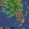
Definitely not restrengthening at this time and confirming the poor radar presentation, inspite of the rather low pressure.
URNT12 KNHC 060354
VORTEX DATA MESSAGE
A. 06/0354Z
B. 28 DEG 31 MIN N
83 DEG 02 MIN W
C. 700 MB 2901 M
D. NA
E. NA
F. 299 DEG 47 KT
G. 221 DEG 97 NM
H. 981 MB
I. 11 C/ 3081 M
J. 12 C/ 3077 M
K. 11 C/ NA
L. NA
M. NA
N. 12345/7
O. .1/1 NM
P. AF963 3206A FRANCES OB 15
MAX FL WIND 58 KT NW QUAD 0305Z.
Latest Frances Vortex ~12 midnight EDT
Moderator: S2k Moderators
Forum rules

The posts in this forum are NOT official forecasts and should not be used as such. They are just the opinion of the poster and may or may not be backed by sound meteorological data. They are NOT endorsed by any professional institution or STORM2K. For official information, please refer to products from the National Hurricane Center and National Weather Service.
For what it's worth...the current satellite presentation reminds me a lot of what Isidore looked like after it was reduced to a shell of it's former self over the Yucatan...
MW
MW
0 likes
Updating on the twitter now: http://www.twitter.com/@watkinstrack
Agreed. Frances is a shell of its former self, and as the NHC noted in its Frances discussion from 5 AM Fri, once the...
HURRICANE WIND FIELD HAS BECOME VERY SPREAD OUT AS THE CENTRAL CORE
WEAKENS...AND IT IS OFTEN DIFFICULT FOR THIS TYPE OF SPREAD OUT
SYSTEM TO RE-CONSOLIDATE
MWatkins wrote:For what it's worth...the current satellite presentation reminds me a lot of what Isidore looked like after it was reduced to a shell of it's former self over the Yucatan...
MW
0 likes
-
Frank P
- S2K Supporter

- Posts: 2779
- Joined: Fri Aug 29, 2003 10:52 am
- Location: Biloxi Beach, Ms
- Contact:
A word of caution.... since the subject Isador was brought up... Isador did not have any convection associated with it as well, just a very large but strong LLC....... but still she had a most impressive storm surge..
Isador put a 8.5 foot surge in Biloxi.... .at least in front of my house on the front beach in Biloxi... more than both hurricanes Elana and Georges.... and the eye of both storms passed over my house.
Isador destroyed a $250.000 pier in front of the Collesium and deposited it a mile down the beach in front of my house.... I got some really nice treated 2X10X12 to prove it... hehe
0 likes
-
Storminole
- Tropical Depression

- Posts: 70
- Age: 64
- Joined: Wed Aug 11, 2004 5:53 pm
- Location: Tallahassee, FL
If Frances is beyond any prospect of strengthening prior to landfall, that's fine with me. The noisy gusts I'm now watching in Tallahassee will make for a sufficient 'wind fix' for now.
I expect this storm to have sufficient push to cause a moderate surge into shallow Apalachee Bay (in the NE corner of the Gulf) during the day tomorrow. The town of St. Marks may flood some even though it's 5 miles inland.
When you've got low pressure in place, a broad wind field and an approaching landfall, I don't think the absence of convection near the center necessarily equals an all-clear.
0 likes

-
Frank P
- S2K Supporter
- Posts: 2779
- Joined: Fri Aug 29, 2003 10:52 am
- Location: Biloxi Beach, Ms
- Contact:
It was an awesome storm surge too wasn't it..... as it was coming in I was sitting in a lawn chair in front of my house on Highway 90 drinking an ice cold barq's root beer .... since it was basically convection free, all I got was wind... funny thing though... the COB Police patrolling the highway saw me, pulled up in my yard with their lights a flashing and wanted to arrest me for trespassing.... at my own house.... I told em to go pound sand, it must have been a rookie officer of something as he left me alone.... I sat and watched the surge all night.....
0 likes
Who is online
Users browsing this forum: No registered users and 189 guests