
With 2 systems in front of her there may/should be some upwelling that would slow intensification down until a bit later I would think. If D and E curve northward and F stayed weak she may not do much until after she gets into clear water which would help it move further westward.
Just my idiots uneducated opinion anyhow.......
PS. I hope I am wrong because if I am correct I may end up having to deal with F. Not something I want to do.
Possible "Fiona" a future U.S/Island threat? (Is Invest 97L)
Moderator: S2k Moderators
Forum rules

The posts in this forum are NOT official forecasts and should not be used as such. They are just the opinion of the poster and may or may not be backed by sound meteorological data. They are NOT endorsed by any professional institution or STORM2K. For official information, please refer to products from the National Hurricane Center and National Weather Service.

Re: Possible "Fiona" a future U.S/Island threat?
wxman57 wrote:The Euro has shown a strong westward bias this season, but that kind of track is certainly possible. I'll let you know for sure in 2 weeks.
Interesting you say that, its shown a east bias with Danielle so far!
Whilst I think there is a real risk this one follows Earl's tracks I'm thinking this one actually has a good shot at getting pretty close right now...
The longer it takes to get going the greater the risk....
Amazing to think we could have 3 hurricanes in the space of say 10 days, gotta love the tropics!
0 likes
Personal Forecast Disclaimer:
The posts in this forum are NOT official forecast and should not be used as such. They are just the opinion of the poster and may or may not be backed by sound meteorological data. They are NOT endorsed by any professional institution or storm2k.org. For official information, please refer to the NHC and NWS products
The posts in this forum are NOT official forecast and should not be used as such. They are just the opinion of the poster and may or may not be backed by sound meteorological data. They are NOT endorsed by any professional institution or storm2k.org. For official information, please refer to the NHC and NWS products
-
cycloneye

- Admin

- Posts: 149508
- Age: 69
- Joined: Thu Oct 10, 2002 10:54 am
- Location: San Juan, Puerto Rico
Re: Possible "Fiona" a future U.S/Island threat?
The latest on the wave that will emerge Africa tommorow.

0 likes
Visit the Caribbean-Central America Weather Thread where you can find at first post web cams,radars
and observations from Caribbean basin members Click Here
and observations from Caribbean basin members Click Here
-
Ivanhater

- Storm2k Moderator

- Posts: 11221
- Age: 39
- Joined: Fri Jul 01, 2005 8:25 am
- Location: Pensacola
Re: Possible "Fiona" a future U.S/Island threat?
18z Nogaps pretty far south with Fiona

0 likes
Michael
-
cycloneye
- Admin
- Posts: 149508
- Age: 69
- Joined: Thu Oct 10, 2002 10:54 am
- Location: San Juan, Puerto Rico
Re: Possible "Fiona" a future U.S/Island threat?

0 likes
Visit the Caribbean-Central America Weather Thread where you can find at first post web cams,radars
and observations from Caribbean basin members Click Here
and observations from Caribbean basin members Click Here
-
Lowpressure

- S2K Supporter

- Posts: 2032
- Age: 59
- Joined: Sun Sep 14, 2003 9:17 am
- Location: Charlotte, North Carolina

-
HurricaneMaster_PR

- Category 2

- Posts: 795
- Joined: Tue Jul 22, 2003 6:23 pm
- Location: San Juan, Puerto Rico
Re: Possible "Fiona" a future U.S/Island threat?
Officially a tropical wave according to latest 00Z TPC Surface Analysis

0 likes

Re: Possible "Fiona" a future U.S/Island threat?
This is the one to really watch...currently just exiting Africa and will be trackfurther south...
00z Nogaps
https://www.fnmoc.navy.mil/wxmap_cgi/cg ... t=Tropical
00z Nogaps
https://www.fnmoc.navy.mil/wxmap_cgi/cg ... t=Tropical
0 likes
-
Wx_Warrior
- Category 5

- Posts: 2718
- Joined: Thu Aug 03, 2006 3:58 pm
- Location: Beaumont, TX
Re: Possible "Fiona" a future U.S/Island threat?
0z GFS with a little help from Earl, gobbles it up....lots of real estate ahead.
0 likes
-
Wx_Warrior
- Category 5
- Posts: 2718
- Joined: Thu Aug 03, 2006 3:58 pm
- Location: Beaumont, TX
Re: Possible "Fiona" a future U.S/Island threat?
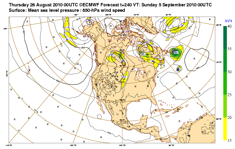
Long range EURO....little "fiona" follows big bro Earl.
0 likes

-
ColinDelia

- S2K Supporter
- Posts: 918
- Joined: Mon Aug 29, 2005 5:52 am
- Location: The Beach, FL
There's about a one degree area of 50 "units" of vorticity NE of clouds. Looks different and stronger than predicted by 0z models.
I noticed in the 0z GFS that the area of vorticity followed Earl closely and stayed just weak enough to not develop. We'll see in
half an hour how that changes.
I noticed in the 0z GFS that the area of vorticity followed Earl closely and stayed just weak enough to not develop. We'll see in
half an hour how that changes.
Last edited by ColinDelia on Thu Aug 26, 2010 6:19 am, edited 1 time in total.
0 likes
-
ColinDelia
- S2K Supporter
- Posts: 918
- Joined: Mon Aug 29, 2005 5:52 am
- Location: The Beach, FL
-
ColinDelia
- S2K Supporter
- Posts: 918
- Joined: Mon Aug 29, 2005 5:52 am
- Location: The Beach, FL
Re: Possible "Fiona" a future U.S/Island threat?
Looks like the 6z GFS mergers this with Earl eventually.
0 likes

Re:
ColinDelia wrote:There's about a one pixel area of 50 "units" of vorticity NE of clouds. Looks different and stronger than predicted by 0z models.
I noticed in the 0z GFS that the area of vorticity followed Earl closely and stayed just weak enough to not develop. We'll see in
half an hour how that changes.
Yeah I just don't buy future Fiona to accerlerate and be absorbed by Earl down the line. It already looks like there is at least +15 deg longitude separating the systems. Plus this disturbance appears like it'll emerge near 10N closer to the CMC and NOGAPs latitude. Hmmm...
0 likes
-
ColinDelia
- S2K Supporter
- Posts: 918
- Joined: Mon Aug 29, 2005 5:52 am
- Location: The Beach, FL

-
ColinDelia
- S2K Supporter
- Posts: 918
- Joined: Mon Aug 29, 2005 5:52 am
- Location: The Beach, FL
-
Gustywind

- Category 5
- Posts: 12334
- Joined: Mon Sep 03, 2007 7:29 am
- Location: Baie-Mahault, GUADELOUPE
From Crownweather: http://www.crownweather.com/?page_id=325
Tropical Weather Discussion
Issued: Thursday, August 26, 2010 610 am EDT/510 am CDT
Discussion
Tropical Wave Near The Coast of Africa:
I continue to keep an eye on a tropical wave that is tracking off of the coast of Africa. I continue to believe that this will be our next tropical depression probably sometime this weekend or at the very latest early next week. Looking at the model guidance for this next system. I am kind of skeptical with some of the guidance like the GFS model which forecasts little or no development because it gets too close to Earl and becomes sheared to death. The reason why I am skeptical is because looking at satellite imagery it appears that this tropical wave has barely moved overnight and I think the spacing between this wave and Earl will be much greater than forecast by the GFS model. The latest European ensemble guidance for days 8 through 10 show a spread in where this system may be. The spread is between Puerto Rico and Hispaniola and 25 North/60 West. It should also be noted that the latest Canadian model forecasts very slow development from this tropical wave and forecasts it to travel pretty far west. In fact, it forecasts a west-northwest track right across the Caribbean ending up near western Cuba in 10 days. In addition, some of the Canadian ensemble model members forecast a tropical system to be located anywhere between just east of the Bahamas to the Gulf of Mexico in 10 days. This feature could either be this tropical wave or another system that develops from a homebrew situation. Needless to say, I will be monitoring this tropical wave closely and will keep you all updated.
The next tropical weather discussion will be issued by 7 am EDT/6 am CDT Friday morning.
Disclaimer: All forecasts herein are made to the best ability of the forecaster. However, due to standard forecasting error, these forecasts cannot be guaranteed. Any action or inaction taken by users of this forecast is the sole responsibility of that user.
0 likes
Who is online
Users browsing this forum: Old-TimeCane and 215 guests