2015 Global model runs discussion
Moderator: S2k Moderators
Forum rules

The posts in this forum are NOT official forecasts and should not be used as such. They are just the opinion of the poster and may or may not be backed by sound meteorological data. They are NOT endorsed by any professional institution or STORM2K. For official information, please refer to products from the National Hurricane Center and National Weather Service.
-
Rgv20

- S2K Supporter

- Posts: 2466
- Age: 39
- Joined: Wed Jan 05, 2011 5:42 pm
- Location: Edinburg/McAllen Tx
12zECMWF Ensemble Control run has a 1004mb Low a little south of the operational run during the 240hr time frame....the individual 12zECMWF Ensemble Members are not that aggressive as the operational run but a few do have 1005mb or lower Lows in the same general area. There is one outlier ensemble member that has a 997mb low just South of LA in 10 days..
0 likes
The following post is NOT an official forecast and should not be used as such. It is just the opinion of the poster and may or may not be backed by sound meteorological data. It is NOT endorsed by any professional institution including storm2k.org For Official Information please refer to the NHC and NWS products.

Models are in excellent agreement that an area of disturbed weather near 65E, will become a significant cyclone.
Could see a landfall in either Pakistan or Iran. May be MUCH stronger than Yemyin in 2007. This is one area that was shown in Yemyin cannot handle cyclones at all. A strong cyclone there could be as bad or worse than a Bangladesh cyclone
Could see a landfall in either Pakistan or Iran. May be MUCH stronger than Yemyin in 2007. This is one area that was shown in Yemyin cannot handle cyclones at all. A strong cyclone there could be as bad or worse than a Bangladesh cyclone
0 likes
-
floridasun78
- Category 5

- Posts: 3755
- Joined: Sun May 17, 2009 10:16 pm
- Location: miami fl
 show area in boc
-
cycloneye

- Admin

- Posts: 149505
- Age: 69
- Joined: Thu Oct 10, 2002 10:54 am
- Location: San Juan, Puerto Rico
Re: Global model runs discussion
12z ECMWF still hanging with the crossover. At 192 hours.

0 likes
Visit the Caribbean-Central America Weather Thread where you can find at first post web cams,radars
and observations from Caribbean basin members Click Here
and observations from Caribbean basin members Click Here
-
Rgv20
- S2K Supporter
- Posts: 2466
- Age: 39
- Joined: Wed Jan 05, 2011 5:42 pm
- Location: Edinburg/McAllen Tx
0zGFS on the aggressive side with regards to TC development in the GOM!
0zGFS 10 day forecast
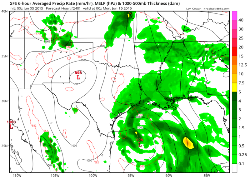
0zGFS 10 day forecast

0 likes
The following post is NOT an official forecast and should not be used as such. It is just the opinion of the poster and may or may not be backed by sound meteorological data. It is NOT endorsed by any professional institution including storm2k.org For Official Information please refer to the NHC and NWS products.

Re: Global model runs discussion
Low looks closed on the higher resolution GFS; done a bit of track and satellite research, and the setup is almost reminding me of Arlene in 1993.

http://www.atmos.albany.edu/student/ppapin/maps/gridsat/1993/gom/ir_sat_gom_6_140.png
http://www.atmos.albany.edu/student/ppapin/maps/gridsat/1993/gom/ir_sat_gom_6_150.png
Edit: EC appears to be up to it's usual 7-8 day disappearing act.
http://www.atmos.albany.edu/student/ppapin/maps/gridsat/1993/gom/ir_sat_gom_6_140.png
http://www.atmos.albany.edu/student/ppapin/maps/gridsat/1993/gom/ir_sat_gom_6_150.png
Edit: EC appears to be up to it's usual 7-8 day disappearing act.
0 likes
The above post is not official and should not be used as such. It is the opinion of the poster and may or may not be backed by sound meteorological data. It is not endorsed by any professional institution or storm2k.org. For official information, please refer to the NHC and NWS products.
-
Dean4Storms
- S2K Supporter
- Posts: 6358
- Age: 63
- Joined: Sun Aug 31, 2003 1:01 pm
- Location: Miramar Bch. FL
Re: Global model runs discussion
Well I see the GEM went off the wall in the 00z run with a near Hurricane into P'Cola by next Friday. 
0 likes
-
stormlover2013
Re: Global model runs discussion
You have to look at pattern the high pressure ridge will block it from florida, this will be Mexico to la storm......if something forms
0 likes

Re: Global model runs discussion
Since the American Media is still not talking about the raging El Niño getting going I guess the models have not gotten the memo yet, hard for anything to get going with so much shear across the Atlantic basin, IMO.
Nothing but EPAC moisture coming across C.A. and MX.
Nothing but EPAC moisture coming across C.A. and MX.
0 likes


Re: Global model runs discussion
I think it is unlikely, and likely always was, that an organized tropical cyclone would cross over Mexico into the GOM, or dissipate over Mexico and redevelop in the GOM. A more likely development scenario is that some of the energy/vorticity from the EPAC crosses over Mexico or Central America and develops in the GOM. This is what most GEFS (GFS ensembles) that show development have been showing. I'm not sure about the probabilities of this scenario, but I think it's more likely than an organized TC crossing Mexico into the GOM.
For what it's worth, it looks like the vorticity origin of the CMC development is near the north coast of South America
It's rather hard to know vertical shear 7-9 days out, and at least the GEFS (GFS ensemble) have been showing favorable conditions in the western and central GOM. The GEPS (Canadian ensemble) has higher shear.
0 likes
-
stormlover2013
Re:
gatorcane wrote:ECMWF dropped the idea of an EPAC crossover BOC system too...
I recall hearing (probably on this forum) that the Euro was upgraded, so let's see if it sticks to it's medium range uncertainty that was prevalent last year. I agree with a few others that whatever develops in the Pacific may simply pull something up out of the Caribbean, and the models could be in the process of trying to resolve this scenario from having had an actual crossover system initially, almost like a back to the drawing board for the runs to figure out how that end result (possible development) would occur.
0 likes
The above post is not official and should not be used as such. It is the opinion of the poster and may or may not be backed by sound meteorological data. It is not endorsed by any professional institution or storm2k.org. For official information, please refer to the NHC and NWS products.
-
WPBWeather

- S2K Supporter
- Posts: 535
- Age: 67
- Joined: Thu Jul 18, 2013 12:33 pm
Re:
Alyono wrote:EC has also totally dropped the Gulf storm idea. Even CMC trended much weaker.
I'd give this at most a 1 in 5 shot now. May be closer to 1 in 10
Maybe not quite gone yet...

0 likes
Re: Re:
WPBWeather wrote:Alyono wrote:EC has also totally dropped the Gulf storm idea. Even CMC trended much weaker.
I'd give this at most a 1 in 5 shot now. May be closer to 1 in 10
Maybe not quite gone yet...
http://imagizer.imageshack.us/v2/1024x768q90/673/SAN4R2.jpg
that's the MU ensemble
0 likes
Who is online
Users browsing this forum: StPeteMike and 293 guests