GFS 18 run still shows tx/la bybrid looking system
http://www.tropicaltidbits.com/analysis ... 0&ypos=255
Tropical wave in the NW Caribbean (Is INVEST 92L)
Moderator: S2k Moderators
Forum rules

The posts in this forum are NOT official forecasts and should not be used as such. They are just the opinion of the poster and may or may not be backed by sound meteorological data. They are NOT endorsed by any professional institution or STORM2K. For official information, please refer to products from the National Hurricane Center and National Weather Service.

Re: Tropical wave in the NW Caribbean
Chances of development are dropping steadily, each run is slightly to the west of the previous run, similar to the system in September that never formed, if the front is even 12 hours later than what's shown it could mean the system ends up over Mexico.
0 likes
The above post is not official and should not be used as such. It is the opinion of the poster and may or may not be backed by sound meteorological data. It is not endorsed by any professional institution or storm2k.org. For official information, please refer to the NHC and NWS products.
-
stormlover2013
Re: Tropical wave in the NW Caribbean
yep no doubt, I just don't see it happening.......I do think texas and la will get pretty good moisture though next week
0 likes

Re: Tropical wave in the NW Caribbean
Hammy wrote:Chances of development are dropping steadily, each run is slightly to the west of the previous run, similar to the system in September that never formed, if the front is even 12 hours later than what's shown it could mean the system ends up over Mexico.
Yeah but it's not August either. The third week of October I suspect anything gets going it'll eventually shift east on future tracks.
0 likes
Re: Tropical wave in the NW Caribbean
ronjon wrote:Hammy wrote:Chances of development are dropping steadily, each run is slightly to the west of the previous run, similar to the system in September that never formed, if the front is even 12 hours later than what's shown it could mean the system ends up over Mexico.
Yeah but it's not August either. The third week of October I suspect anything gets going it'll eventually shift east on future tracks.
Pressures have been significantly higher than normal during much of October so there's still a chance this may be over land during the time the low would have otherwise formed. Either way a good amount of rain is likely to come out of it.
0 likes
The above post is not official and should not be used as such. It is the opinion of the poster and may or may not be backed by sound meteorological data. It is not endorsed by any professional institution or storm2k.org. For official information, please refer to the NHC and NWS products.
-
Miami Storm Tracker

- Category 4

- Posts: 916
- Age: 68
- Joined: Sun Jun 13, 2010 10:12 pm
- Location: Key Largo, Fla.
- Contact:
Re: Tropical wave in the NW Caribbean
A little off topic so from what I can see and reading all these post. No tropical development through the weekend. Be it BOC or western CARIB. So why does my weekend planned for fishing in the Keys have to be so screwed up, windy and rain. Not a happy camper right now. Back to talking tropics.
0 likes


Re: Tropical wave in the NW Caribbean
0Z MU hits central TX coast with a strong TS (~996 mb) hour 228 (10/25).
Edit: Any others like it? Not easy to find but Jerry of 1989, which was earlier in the month, might be one to consider somewhat:
http://weather.unisys.com/hurricane/atl ... /track.gif
Edit: Any others like it? Not easy to find but Jerry of 1989, which was earlier in the month, might be one to consider somewhat:
http://weather.unisys.com/hurricane/atl ... /track.gif
0 likes
Personal Forecast Disclaimer:
The posts in this forum are NOT official forecasts and should not be used as such. They are just the opinion of the poster and may or may not be backed by sound meteorological data. They are NOT endorsed by any professional institution or storm2k.org. For official information, please refer to the NHC and NWS products.
The posts in this forum are NOT official forecasts and should not be used as such. They are just the opinion of the poster and may or may not be backed by sound meteorological data. They are NOT endorsed by any professional institution or storm2k.org. For official information, please refer to the NHC and NWS products.
-
1900hurricane

- Category 5

- Posts: 6063
- Age: 34
- Joined: Fri Feb 06, 2015 12:04 pm
- Location: Houston, TX
- Contact:
After Jerry, the only other storm I can think of off the top of my head was an October 1949 hurricane. Tropical cyclones affecting the NW Gulf after September are pretty rare.
0 likes
Contract Meteorologist. TAMU & MSST. Fiercely authentic, one of a kind. We are all given free will, so choose a life meant to be lived. We are the Masters of our own Stories.
Opinions expressed are mine alone.
Follow me on Twitter at @1900hurricane : Read blogs at https://1900hurricane.wordpress.com/
Opinions expressed are mine alone.
Follow me on Twitter at @1900hurricane : Read blogs at https://1900hurricane.wordpress.com/

0Z CMC: hit on west central LA hour 210 (10/24) at 993 mb. Could be close to a H.
0 likes
Personal Forecast Disclaimer:
The posts in this forum are NOT official forecasts and should not be used as such. They are just the opinion of the poster and may or may not be backed by sound meteorological data. They are NOT endorsed by any professional institution or storm2k.org. For official information, please refer to the NHC and NWS products.
The posts in this forum are NOT official forecasts and should not be used as such. They are just the opinion of the poster and may or may not be backed by sound meteorological data. They are NOT endorsed by any professional institution or storm2k.org. For official information, please refer to the NHC and NWS products.
Re: Tropical wave in the NW Caribbean
Track further west once again, and straight north rather than northeast. Development chances dropping even further--tomorrow's runs will probably just have a lot of rain inland over Mexico moving north.
0 likes
The above post is not official and should not be used as such. It is the opinion of the poster and may or may not be backed by sound meteorological data. It is not endorsed by any professional institution or storm2k.org. For official information, please refer to the NHC and NWS products.
Re: Tropical wave in the NW Caribbean
Hammy wrote:Track further west once again, and straight north rather than northeast. Development chances dropping even further--tomorrow's runs will probably just have a lot of rain inland over Mexico moving north.
Hammy, you staying up for the Euro?
The 0Z GEFS has a whole heck of a lot of TX and LA landfalls 10/23-5.
0 likes
Personal Forecast Disclaimer:
The posts in this forum are NOT official forecasts and should not be used as such. They are just the opinion of the poster and may or may not be backed by sound meteorological data. They are NOT endorsed by any professional institution or storm2k.org. For official information, please refer to the NHC and NWS products.
The posts in this forum are NOT official forecasts and should not be used as such. They are just the opinion of the poster and may or may not be backed by sound meteorological data. They are NOT endorsed by any professional institution or storm2k.org. For official information, please refer to the NHC and NWS products.
Re: Tropical wave in the NW Caribbean
Hammy wrote:Track further west once again, and straight north rather than northeast. Development chances dropping even further--tomorrow's runs will probably just have a lot of rain inland over Mexico moving north.
what in the world are you talking about by saying development chances decreasing? How can one come to that conclusion when the models trend more aggressive and more tropical?
0 likes
Re: Tropical wave in the NW Caribbean
Alyono wrote:Hammy wrote:Track further west once again, and straight north rather than northeast. Development chances dropping even further--tomorrow's runs will probably just have a lot of rain inland over Mexico moving north.
what in the world are you talking about by saying development chances decreasing? How can one come to that conclusion when the models trend more aggressive and more tropical?
Model trend has been further west each time, and the movement has been more northward--it just seems like eventually the starting point is going to end up over land and not make it over water to start with if the trend continues.
LarryWx wrote: Hammy, you staying up for the Euro?
Always do.
Last edited by Hammy on Fri Oct 16, 2015 1:40 am, edited 1 time in total.
0 likes
The above post is not official and should not be used as such. It is the opinion of the poster and may or may not be backed by sound meteorological data. It is not endorsed by any professional institution or storm2k.org. For official information, please refer to the NHC and NWS products.
Re: Tropical wave in the NW Caribbean
LarryWx wrote: Hammy, you staying up for the Euro?
Always do.[/quote]
It is hard to go to sleep before the Euro in these potentially dramatic situations.
0Z Euro hour 192: 150 miles E of Brownsville moving NE for now 999 mb
Edit: 216: 993 mb H? 150 miles S of LA moving NE but maybe turning more NNE...headed for LA as stronger high in SE US?
Edit: Major flooding TX/LA coasts from very heavy rain (6-10") with it being a slow mover would be a problem if it were to take this track. Just offshore LA at 240.
Bedtime calling lol.
0 likes
Personal Forecast Disclaimer:
The posts in this forum are NOT official forecasts and should not be used as such. They are just the opinion of the poster and may or may not be backed by sound meteorological data. They are NOT endorsed by any professional institution or storm2k.org. For official information, please refer to the NHC and NWS products.
The posts in this forum are NOT official forecasts and should not be used as such. They are just the opinion of the poster and may or may not be backed by sound meteorological data. They are NOT endorsed by any professional institution or storm2k.org. For official information, please refer to the NHC and NWS products.
Re:
Euro is almost identical to last run track-wise, so the westward trend seems to be with the GFS.
Is it showing up as more tropical as well this run as the GFS went?
Alyono wrote:EC trended stronger
Is it showing up as more tropical as well this run as the GFS went?
0 likes
The above post is not official and should not be used as such. It is the opinion of the poster and may or may not be backed by sound meteorological data. It is not endorsed by any professional institution or storm2k.org. For official information, please refer to the NHC and NWS products.
Re: Tropical wave in the NW Caribbean
Hammy, you can't trust any model some 8 days out in terms of a location it will hit. I do see a trend for development and at this point that seems more important, in my opinion.
0 likes

Re: Tropical wave in the NW Caribbean
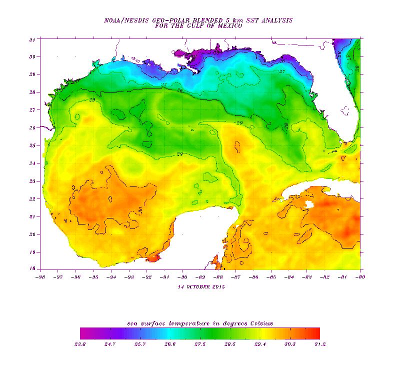
Detailed SSTs over the GOM, still very warm over the BOC, warm enough over the rest of GOM, the only sub 80 degs area are the immediate coastal waters of the north central gulf coast.

0 likes
Who is online
Users browsing this forum: Ulf and 87 guests