http://i.imgur.com/YE3J9PB.jpg

Moderator: S2k Moderators


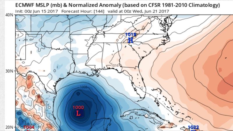
Steve wrote:Yeah. It approaches from the south about the MS/AL Line (8ish?) as 993mb at 144 hours. It sort of stutter steps or stalls out for a few hours and then landfalls around 174/180 hours showing 997mb on the low res around the Santa Rosa/Okaloosa County border or maybe 85ish miles west of the 18z.
?


A complex area of low pressure is expected to form over the
northwestern Caribbean Sea and the adjacent Yucatan peninsula by the
weekend. Conditions appear to be favorable for some development of
this system while it moves slowly northwestward toward the southern
Gulf of Mexico by early next week.
* Formation chance through 48 hours...low...near 0 percent.
* Formation chance through 5 days...medium...40 percent.

Hammy wrote:Quite odd that NHC is upping the numbers, considering anything beyond a disorganized monsoonal gyre seems increasingly less likely with each model run.

AtlanticWind wrote:Hammy wrote:Quite odd that NHC is upping the numbers, considering anything beyond a disorganized monsoonal gyre seems increasingly less likely with each model run.
That's not really an accurate observation. All the models but the gfs show development and the gfs Para even shows
at least a depression. Also convection continues to increase in the western carribean. An argument could be made the NHC
Is being conservative.

northjaxpro wrote:AtlanticWind wrote:Hammy wrote:Quite odd that NHC is upping the numbers, considering anything beyond a disorganized monsoonal gyre seems increasingly less likely with each model run.
That's not really an accurate observation. All the models but the gfs show development and the gfs Para even shows
at least a depression. Also convection continues to increase in the western carribean. An argument could be made the NHC
Is being conservative.
Agree. The models are in very good agreement that we will see a tropical cyclone in the GOM by the middle of next week at least.


Hammy wrote:northjaxpro wrote:AtlanticWind wrote:That's not really an accurate observation. All the models but the gfs show development and the gfs Para even shows
at least a depression. Also convection continues to increase in the western carribean. An argument could be made the NHC
Is being conservative.
Agree. The models are in very good agreement that we will see a tropical cyclone in the GOM by the middle of next week at least.
Are any semi-reliable models showing development? GFS-Para is somewhat untested tropically (and somebody else pointed out earlier it hasn't done well in general) and the GEM seems to develop just about every cloud that forms over the tropics.
Users browsing this forum: cycloneye and 242 guests