
Tropical Wave over the SE Bahamas (Is INVEST 91L)
Moderator: S2k Moderators
Forum rules

The posts in this forum are NOT official forecasts and should not be used as such. They are just the opinion of the poster and may or may not be backed by sound meteorological data. They are NOT endorsed by any professional institution or STORM2K. For official information, please refer to products from the National Hurricane Center and National Weather Service.
-
cycloneye

- Admin

- Posts: 149369
- Age: 69
- Joined: Thu Oct 10, 2002 10:54 am
- Location: San Juan, Puerto Rico
Re: Tropical Wave in East Atlantic
The CMC continues to develop this wave and tracks it in this 00z run to the Georgia/South Carolina border.
0 likes
Visit the Caribbean-Central America Weather Thread where you can find at first post web cams,radars
and observations from Caribbean basin members Click Here
and observations from Caribbean basin members Click Here
-
cycloneye
- Admin
- Posts: 149369
- Age: 69
- Joined: Thu Oct 10, 2002 10:54 am
- Location: San Juan, Puerto Rico
Re: Tropical Wave in East Atlantic
Discussion of wave from the San Juan NWS.
On Tuesday
night, showers will not taper off as much over eastern Puerto
Rico as the moisture associated with the wave moves into the area.
The GFS has been inconsistent with whether better activity should
be expected Wednesday or Thursday. Certainty in rain chances,
though, is higher on Wednesday and some thunderstorms will be seen
island wide and possibly around the U.S. Virgin Islands then as
well, but moisture levels are still excellent on Thursday and
there is considerable instability in both Wednesday and Thursday`s
18Z forecast soundings showing minus 8 lifted indices. Neither day
appears to have upper level dynamic support like Tuesday to add
complications to the forecast. At this time am leaning toward the
best activity being on Wednesday by a narrow margin.
0 likes
Visit the Caribbean-Central America Weather Thread where you can find at first post web cams,radars
and observations from Caribbean basin members Click Here
and observations from Caribbean basin members Click Here
-
gatorcane

- S2K Supporter

- Posts: 23708
- Age: 48
- Joined: Sun Mar 13, 2005 3:54 pm
- Location: Boca Raton, FL
Re: Tropical Wave in East Atlantic
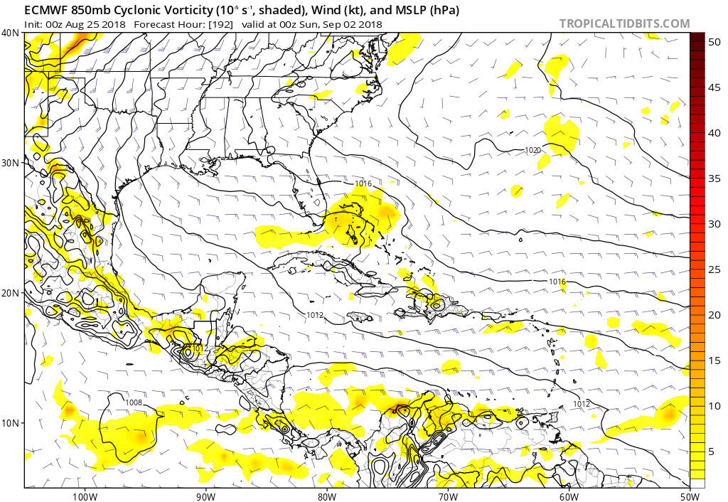
00Z position of wave at 192 hours, heading through Bahamas:
0 likes
-
cycloneye
- Admin
- Posts: 149369
- Age: 69
- Joined: Thu Oct 10, 2002 10:54 am
- Location: San Juan, Puerto Rico
Re: Tropical Wave in East Atlantic
8 AM TWD:
A far eastern Atlantic Ocean tropical wave is moving across the
area of the Cabo Verde Islands, along 24W/25W from 20N southward.
Broken to overcast multilayered clouds and possible rainshowers
cover the area that is from 14N to 24N between 25W and 37W
area of the Cabo Verde Islands, along 24W/25W from 20N southward.
Broken to overcast multilayered clouds and possible rainshowers
cover the area that is from 14N to 24N between 25W and 37W
0 likes
Visit the Caribbean-Central America Weather Thread where you can find at first post web cams,radars
and observations from Caribbean basin members Click Here
and observations from Caribbean basin members Click Here


Re: Tropical Wave in East Atlantic
In natural color. I'd have to say Levi and tidbits has done a great job with the imagery.

4 likes
The above post and any post by Ntxw is NOT an official forecast and should not be used as such. It is just the opinion of the poster and may or may not be backed by sound meteorological data. It is NOT endorsed by any professional institution including Storm2k. For official information, please refer to NWS products.
Help support Storm2K!
-
stormlover2013
-
floridasun78
- Category 5

- Posts: 3755
- Joined: Sun May 17, 2009 10:16 pm
- Location: miami fl
Re: Tropical Wave in East Atlantic
look this wave having hard time to getting moist with it because with going lone with sal
0 likes
-
gatorcane
- S2K Supporter
- Posts: 23708
- Age: 48
- Joined: Sun Mar 13, 2005 3:54 pm
- Location: Boca Raton, FL
Re: Tropical Wave in East Atlantic
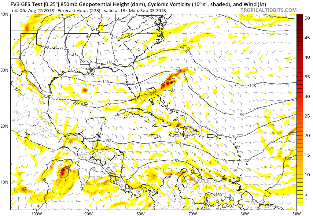
FV3 GFS going with development again as it approaches Florida and has it crossing the peninsula into the Gulf where it develops further. The model is interestingly very close to the CMC as far as track as that timeframe:
0 likes
Re: Tropical Wave in East Atlantic
FWIW, The German Icon model shows it developing east of the Bahamas on Wednesday.
0 likes

Re: Tropical Wave in East Atlantic
I'm curious why some models show the Bermuda High weakening, allowing for an Eastern solutions, while some keep it stout and push it toward the Central U.S.
0 likes
Personal Forecast Disclaimer:
The posts in this forum are NOT official forecast and should not be used as such. They are just the opinion of the poster and may or may not be backed by sound meteorological data. They are NOT endorsed by any professional institution or storm2k.org. For official information, please refer to the NHC and NWS products.
The posts in this forum are NOT official forecast and should not be used as such. They are just the opinion of the poster and may or may not be backed by sound meteorological data. They are NOT endorsed by any professional institution or storm2k.org. For official information, please refer to the NHC and NWS products.
-
cycloneye
- Admin
- Posts: 149369
- Age: 69
- Joined: Thu Oct 10, 2002 10:54 am
- Location: San Juan, Puerto Rico
Re: Tropical Wave in East Atlantic
2 PM TWD: I think this added wave is the one some models are latching on.
An Atlantic Ocean tropical wave is along 34W/35W from 19N
southward. This wave was added to the 25/1200 UTC map analysis
based on long loop satellite imagery and computer model
diagnostics. Broken to overcast multilayered clouds and possible
rainshowers cover the area that is from 14N to 24N between 30W and
40W.
southward. This wave was added to the 25/1200 UTC map analysis
based on long loop satellite imagery and computer model
diagnostics. Broken to overcast multilayered clouds and possible
rainshowers cover the area that is from 14N to 24N between 30W and
40W.
0 likes
Visit the Caribbean-Central America Weather Thread where you can find at first post web cams,radars
and observations from Caribbean basin members Click Here
and observations from Caribbean basin members Click Here
Re: Tropical Wave in East Atlantic
floridasun78 wrote:look this wave having hard time to getting moist with it because with going lone with sal
And yet, SAL is back-filling right after it passes through, though you can definitely see less SAL than we have even a few weeks ago at its peak. And much less in front of it, though the shear in front of it is also high.

0 likes
Personal Forecast Disclaimer:
The posts in this forum are NOT official forecast and should not be used as such. They are just the opinion of the poster and may or may not be backed by sound meteorological data. They are NOT endorsed by any professional institution or storm2k.org. For official information, please refer to the NHC and NWS products.
The posts in this forum are NOT official forecast and should not be used as such. They are just the opinion of the poster and may or may not be backed by sound meteorological data. They are NOT endorsed by any professional institution or storm2k.org. For official information, please refer to the NHC and NWS products.
Re: Tropical Wave in East Atlantic (34W-35W)
Is there a term for waves that cross the Atlantic and don't form until the Bahamas or so? Short notice systems always bugged me.
0 likes
-
cycloneye
- Admin
- Posts: 149369
- Age: 69
- Joined: Thu Oct 10, 2002 10:54 am
- Location: San Juan, Puerto Rico
Re: Tropical Wave in East Atlantic
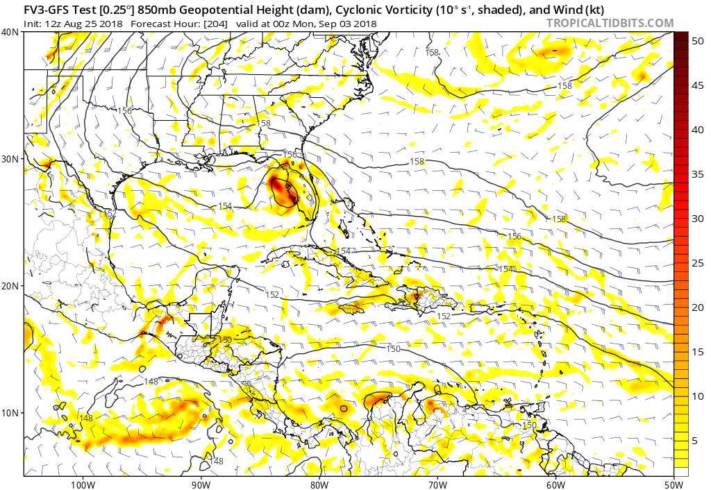
FV3 again develops this wave. Tracks it thru Bahamas,Florida Penninsula and ends in Louisiana.

0 likes
Visit the Caribbean-Central America Weather Thread where you can find at first post web cams,radars
and observations from Caribbean basin members Click Here
and observations from Caribbean basin members Click Here
-
AutoPenalti
- Category 5
- Posts: 4091
- Age: 29
- Joined: Mon Aug 17, 2015 4:16 pm
- Location: Ft. Lauderdale, Florida
Re: Tropical Wave in East Atlantic (34W-35W)
BobHarlem wrote:Is there a term for waves that cross the Atlantic and don't form until the Bahamas or so? Short notice systems always bugged me.
Sleeper waves?
1 likes
The posts in this forum are NOT official forecasts and should not be used as such. They are just the opinion of the poster and may or may not be backed by sound meteorological data. They are NOT endorsed by any professional institution or STORM2K. For official information, please refer to products from the NHC and NWS.
Model Runs Cheat Sheet:
GFS (5:30 AM/PM, 11:30 AM/PM)
HWRF, GFDL, UKMET, NAVGEM (6:30-8:00 AM/PM, 12:30-2:00 AM/PM)
ECMWF (1:45 AM/PM)
TCVN is a weighted averaged
-
cycloneye
- Admin
- Posts: 149369
- Age: 69
- Joined: Thu Oct 10, 2002 10:54 am
- Location: San Juan, Puerto Rico
Re: Tropical Wave in East Atlantic
Surprised nobody posted the Euro  that has this wave in GOM to Louisiana from days 7 thru 10.

0 likes
Visit the Caribbean-Central America Weather Thread where you can find at first post web cams,radars
and observations from Caribbean basin members Click Here
and observations from Caribbean basin members Click Here

Re: Tropical Wave in East Atlantic
Based on the ECM, could be labor day storm in the GOM next weekend.
0 likes
-
floridasun78
- Category 5
- Posts: 3755
- Joined: Sun May 17, 2009 10:16 pm
- Location: miami fl
Re: Tropical Wave in East Atlantic
we see if any thing happen to wave before looking at models wave look very weak now
0 likes
-
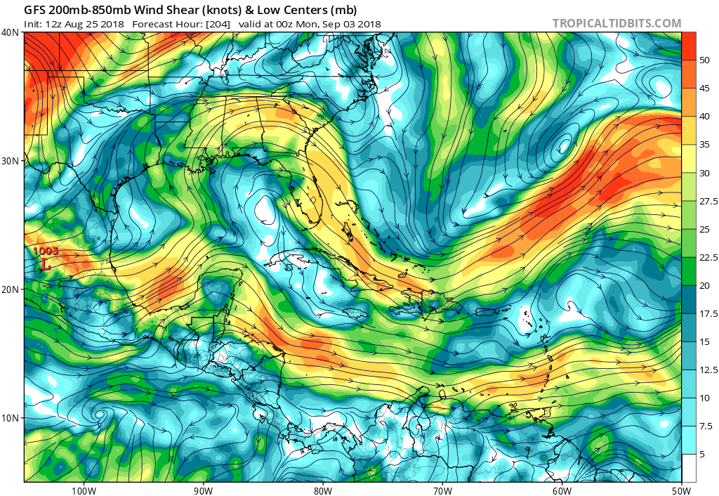
gatorcane
- S2K Supporter
- Posts: 23708
- Age: 48
- Joined: Sun Mar 13, 2005 3:54 pm
- Location: Boca Raton, FL
Re: Tropical Wave in East Atlantic
The GFS is an outlier at the moment as far as it showing basically nothing in the GOM with this wave. The FV3 GFS, CMC, and ECMWF show some kind of organization (albeit weak on the ECMWF). But the GFS does show an environment conducive for development if this wave makes the journey there in tact. It wouldn’t surprise me if the GFS jumps on the development bandwagon soon:
0 likes
Who is online
Users browsing this forum: kevin and 124 guests