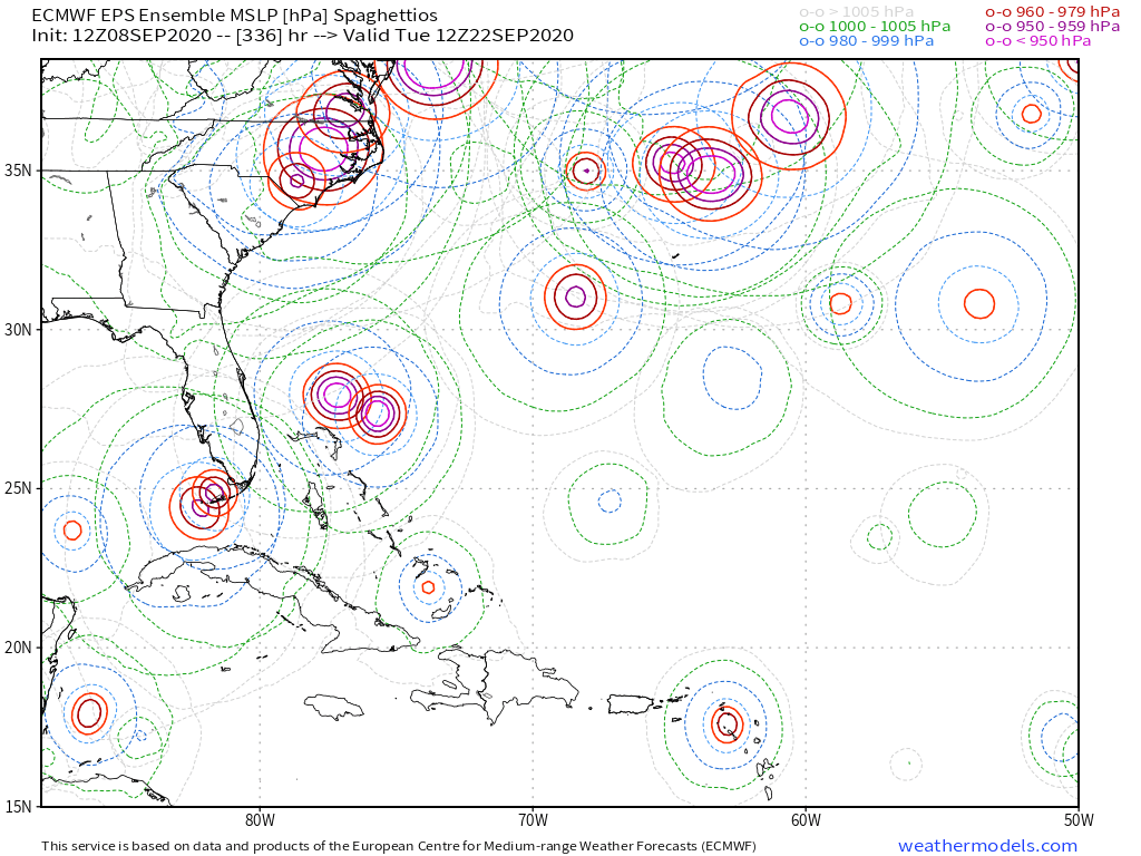
Tropical Wave has emerged from West Africa (Is Invest 95L)

This is the general tropical discussion area. Anyone can take their shot at predicting a storms path.

Moderator: S2k Moderators

Forum rules

The posts in this forum are NOT official forecasts and should not be used as such. They are just the opinion of the poster and may or may not be backed by sound meteorological data. They are NOT endorsed by any professional institution or STORM2K. For official information, please refer to products from the National Hurricane Center and National Weather Service.

Help Support Storm2K
Message
Author
TheStormExpert

Re: Tropical Wave inside Africa

#101 Postby TheStormExpert » Tue Sep 08, 2020 12:30 pm


This far out I wouldn't write off a track through the Caribbean and into Central America or Mexico. I think the CFS is hinting at that.
0 likes   

User avatar
cycloneye
Admin
Admin
Posts: 145255
Age: 68
Joined: Thu Oct 10, 2002 10:54 am
Location: San Juan, Puerto Rico

Re: Tropical Wave inside Africa

#102 Postby cycloneye » Tue Sep 08, 2020 12:33 pm

A tropical wave is forecast to emerge off the west coast of Africa
on Thursday. Gradual development is expected once the system moves
over water, and a tropical depression is likely to form late this
week or over the weekend while the system moves generally westward
across the eastern tropical Atlantic.
* Formation chance through 48 hours...low...10 percent.
* Formation chance through 5 days...high...70 percent.


Image

Image
0 likes   
Visit the Caribbean-Central America Weather Thread where you can find at first post web cams,radars
and observations from Caribbean basin members Click Here

USTropics
Professional-Met
Professional-Met
Posts: 2646
Joined: Sun Aug 12, 2007 3:45 am
Location: Florida State University

Re: Tropical Wave inside Africa

#103 Postby USTropics » Tue Sep 08, 2020 12:34 pm

tomatkins wrote:
toad strangler wrote:
Hurricaneman wrote:The 12zGFS shows this heading to the southern Lesser Antilles, way SW of the 6z run


Energy splits into two after splashdown with one half doing a Texas Two Step with Rene. Bizarre.


tropicaltidbits conked out at hr 228, but it looks like the remnants of Rene and Paulette are both still in the central Atlantic when future Sandy/Teddy enters the picture.


NCEP servers are having issues.

Sep 8: The NOAA data center is having problems and some NCEP models (including GFS) are currently delayed
0 likes   

TheStormExpert

Re: Tropical Wave inside Africa

#104 Postby TheStormExpert » Tue Sep 08, 2020 12:35 pm

cycloneye wrote:
A tropical wave is forecast to emerge off the west coast of Africa
on Thursday. Gradual development is expected once the system moves
over water, and a tropical depression is likely to form late this
week or over the weekend while the system moves generally westward
across the eastern tropical Atlantic.
* Formation chance through 48 hours...low...10 percent.
* Formation chance through 5 days...high...70 percent.

Now that the 48hr. chances are there it should be quickly deemed an Invest on Thursday when it emerges, if not sooner?
0 likes   

TheStormExpert

Re: Tropical Wave inside Africa

#105 Postby TheStormExpert » Tue Sep 08, 2020 12:36 pm

USTropics wrote:
tomatkins wrote:
toad strangler wrote:
Energy splits into two after splashdown with one half doing a Texas Two Step with Rene. Bizarre.


tropicaltidbits conked out at hr 228, but it looks like the remnants of Rene and Paulette are both still in the central Atlantic when future Sandy/Teddy enters the picture.


NCEP servers are having issues.

Sep 8: The NOAA data center is having problems and some NCEP models (including GFS) are currently delayed

So does this mean this afternoons 12z Euro will run on Tropical Tidbits?
0 likes   

User avatar
Spacecoast
Category 2
Category 2
Posts: 758
Joined: Thu Aug 31, 2017 2:03 pm

Re: Tropical Wave inside Africa

#106 Postby Spacecoast » Tue Sep 08, 2020 12:38 pm

12z GEFS: 73% Probability with 16 members showing genesis (out of 22)

Image
1 likes   

USTropics
Professional-Met
Professional-Met
Posts: 2646
Joined: Sun Aug 12, 2007 3:45 am
Location: Florida State University

Re: Tropical Wave inside Africa

#107 Postby USTropics » Tue Sep 08, 2020 12:48 pm

TheStormExpert wrote:
USTropics wrote:
tomatkins wrote:
tropicaltidbits conked out at hr 228, but it looks like the remnants of Rene and Paulette are both still in the central Atlantic when future Sandy/Teddy enters the picture.


NCEP servers are having issues.

Sep 8: The NOAA data center is having problems and some NCEP models (including GFS) are currently delayed

So does this mean this afternoons 12z Euro will run on Tropical Tidbits?


Shouldn't be a problem for ECMWF or UKMET models as they are hosted at their own facilities. CMC/GFDL/HWRF could be affected.
0 likes   

us89
Category 1
Category 1
Posts: 399
Joined: Wed Sep 04, 2019 11:12 pm
Location: Tallahassee, FL

Re: Tropical Wave inside Africa

#108 Postby us89 » Tue Sep 08, 2020 1:53 pm

USTropics wrote:
tomatkins wrote:
toad strangler wrote:
Energy splits into two after splashdown with one half doing a Texas Two Step with Rene. Bizarre.


tropicaltidbits conked out at hr 228, but it looks like the remnants of Rene and Paulette are both still in the central Atlantic when future Sandy/Teddy enters the picture.


NCEP servers are having issues.

Sep 8: The NOAA data center is having problems and some NCEP models (including GFS) are currently delayed


So that's why the MOS site has been giving me products from September 3rd for the last few days...
0 likes   

TheStormExpert

Re: Tropical Wave inside Africa

#109 Postby TheStormExpert » Tue Sep 08, 2020 1:55 pm

12z Euro MUCH weaker.
0 likes   

User avatar
Hypercane_Kyle
Category 5
Category 5
Posts: 3351
Joined: Sat Mar 07, 2015 7:58 pm
Location: Cape Canaveral, FL

Re: Tropical Wave inside Africa

#110 Postby Hypercane_Kyle » Tue Sep 08, 2020 2:05 pm

TheStormExpert wrote:12z Euro MUCH weaker.


Horrendous consistency. 00z yesterday was a major hurricane, 12z yesterday was a weak tropical storm, 00z run was a major hurricane, 12z run back to a tropical storm.

Frustrating how poorly this model has performed this season in terms of intensity.
1 likes   
My posts are my own personal opinion, defer to the National Hurricane Center (NHC) and other NOAA products for decision making during hurricane season.

User avatar
CyclonicFury
Category 5
Category 5
Posts: 2025
Age: 26
Joined: Sun Jul 02, 2017 12:32 pm
Location: NC
Contact:

Re: Tropical Wave inside Africa

#111 Postby CyclonicFury » Tue Sep 08, 2020 2:07 pm

Hypercane_Kyle wrote:
TheStormExpert wrote:12z Euro MUCH weaker.


Horrendous consistency. 00z yesterday was a major hurricane, 12z yesterday was a weak tropical storm, 00z run was a major hurricane, 12z run back to a tropical storm.

Frustrating how poorly this model has performed this season in terms of intensity.

Indeed. The ECMWF had many runs where it showed Laura opening up into a wave near the Bahamas and never redeveloping, but this obviously did not pan out. It also never really developed Marco or Nana at all until they actually developed.
2 likes   
NCSU B.S. in Meteorology Class of 2021. Tropical weather blogger at http://www.cyclonicfury.com. My forecasts and thoughts are NOT official, for official forecasts please consult the National Hurricane Center.

User avatar
Hypercane_Kyle
Category 5
Category 5
Posts: 3351
Joined: Sat Mar 07, 2015 7:58 pm
Location: Cape Canaveral, FL

Re: Tropical Wave inside Africa

#112 Postby Hypercane_Kyle » Tue Sep 08, 2020 2:09 pm

CyclonicFury wrote:
Hypercane_Kyle wrote:
TheStormExpert wrote:12z Euro MUCH weaker.


Horrendous consistency. 00z yesterday was a major hurricane, 12z yesterday was a weak tropical storm, 00z run was a major hurricane, 12z run back to a tropical storm.

Frustrating how poorly this model has performed this season in terms of intensity.

Indeed. The ECMWF had many runs where it showed Laura opening up into a wave near the Bahamas and never redeveloping, but this obviously did not pan out. It also never really developed Marco or Nana at all until they actually developed.


12z GFS run was also garbage IMO. Randomly splits vorticity off from this wave emerging off Africa and makes it into a major hurricane.
0 likes   
My posts are my own personal opinion, defer to the National Hurricane Center (NHC) and other NOAA products for decision making during hurricane season.

User avatar
aspen
Category 5
Category 5
Posts: 8818
Joined: Sat Oct 12, 2019 7:10 pm
Location: Connecticut, USA

Re: Tropical Wave inside Africa

#113 Postby aspen » Tue Sep 08, 2020 2:12 pm

Hypercane_Kyle wrote:
CyclonicFury wrote:
Hypercane_Kyle wrote:
Horrendous consistency. 00z yesterday was a major hurricane, 12z yesterday was a weak tropical storm, 00z run was a major hurricane, 12z run back to a tropical storm.

Frustrating how poorly this model has performed this season in terms of intensity.

Indeed. The ECMWF had many runs where it showed Laura opening up into a wave near the Bahamas and never redeveloping, but this obviously did not pan out. It also never really developed Marco or Nana at all until they actually developed.


12z GFS run was also garbage IMO. Randomly splits vorticity off from this wave emerging off Africa and makes it into a major hurricane.

It splits the wave into a Rene copycat and a Charlie ‘04 analogue. Maybe it’s trying to hone in on two separate waves developing?
0 likes   
Irene '11 Sandy '12 Hermine '16 5/15/2018 Derecho Fay '20 Isaias '20 Elsa '21 Henri '21 Ida '21

I am only a meteorology enthusiast who knows a decent amount about tropical cyclones. Look to the professional mets, the NHC, or your local weather office for the best information.

User avatar
HurricaneAndre2008
Category 1
Category 1
Posts: 334
Age: 27
Joined: Wed Jul 31, 2019 9:51 pm
Contact:

Re: Tropical Wave inside Africa

#114 Postby HurricaneAndre2008 » Tue Sep 08, 2020 2:15 pm

You guys know the Euro is a track model right?
0 likes   
Cindy(2005), Katrina(2005), Rita(2005), Erin(2007), Isaac(2012)

MJGarrison
Tropical Storm
Tropical Storm
Posts: 146
Joined: Wed Aug 30, 2017 7:26 pm

Re: Tropical Wave inside Africa

#115 Postby MJGarrison » Tue Sep 08, 2020 2:32 pm

It might be more accurate to say that the Euro is a Global Model. Other hurricane models are specifically programmed to better model the lower level processes of the hurricanes, giving a more accurate look at intensity. The Euro is not programmed specifically for hurricane tracks.


Sent from my iPad using Tapatalk
0 likes   

AutoPenalti
Category 5
Category 5
Posts: 4030
Age: 29
Joined: Mon Aug 17, 2015 4:16 pm
Location: Ft. Lauderdale, Florida

Re: Tropical Wave inside Africa

#116 Postby AutoPenalti » Tue Sep 08, 2020 2:38 pm

HurricaneAndre2008 wrote:You guys know the Euro is a track model right?

It does handle intensity as well, albeit at a lower resolution.
0 likes   
The posts in this forum are NOT official forecasts and should not be used as such. They are just the opinion of the poster and may or may not be backed by sound meteorological data. They are NOT endorsed by any professional institution or STORM2K. For official information, please refer to products from the NHC and NWS.


Model Runs Cheat Sheet:
GFS (5:30 AM/PM, 11:30 AM/PM)
HWRF, GFDL, UKMET, NAVGEM (6:30-8:00 AM/PM, 12:30-2:00 AM/PM)
ECMWF (1:45 AM/PM)

TCVN
is a weighted averaged

User avatar
SFLcane
S2K Supporter
S2K Supporter
Posts: 10163
Age: 47
Joined: Sat Jun 05, 2010 1:44 pm
Location: Lake Worth Florida

Re: Tropical Wave inside Africa

#117 Postby SFLcane » Tue Sep 08, 2020 2:39 pm

Holy EPS! This just got really interesting..

Barrage of majors near SFL...
Last edited by SFLcane on Tue Sep 08, 2020 2:42 pm, edited 1 time in total.
0 likes   

User avatar
cycloneye
Admin
Admin
Posts: 145255
Age: 68
Joined: Thu Oct 10, 2002 10:54 am
Location: San Juan, Puerto Rico

Re: Tropical Wave inside Africa

#118 Postby cycloneye » Tue Sep 08, 2020 2:40 pm

SFLcane wrote:Holy EPS! This just got really interesting..


What? Give us more. :D
0 likes   
Visit the Caribbean-Central America Weather Thread where you can find at first post web cams,radars
and observations from Caribbean basin members Click Here

AutoPenalti
Category 5
Category 5
Posts: 4030
Age: 29
Joined: Mon Aug 17, 2015 4:16 pm
Location: Ft. Lauderdale, Florida

Re: Tropical Wave inside Africa

#119 Postby AutoPenalti » Tue Sep 08, 2020 2:42 pm

SFLcane wrote:Holy EPS! This just got really interesting..

Barrage of majors near SFL...

Need the sauce! :double:
0 likes   
The posts in this forum are NOT official forecasts and should not be used as such. They are just the opinion of the poster and may or may not be backed by sound meteorological data. They are NOT endorsed by any professional institution or STORM2K. For official information, please refer to products from the NHC and NWS.


Model Runs Cheat Sheet:
GFS (5:30 AM/PM, 11:30 AM/PM)
HWRF, GFDL, UKMET, NAVGEM (6:30-8:00 AM/PM, 12:30-2:00 AM/PM)
ECMWF (1:45 AM/PM)

TCVN
is a weighted averaged

User avatar
blp
Category 5
Category 5
Posts: 2840
Age: 46
Joined: Thu Sep 09, 2004 7:51 pm
Location: Miami, FL
Contact:

Re: Tropical Wave inside Africa

#120 Postby blp » Tue Sep 08, 2020 2:45 pm

Here is what he is talking about:
Image
0 likes   
The following post is NOT an official forecast and should not be used as such. It is just the opinion of the poster and may or may not be backed by sound meteorological data. It is NOT endorsed by any professional institution including storm2k.org For Official Information please refer to the NHC and NWS products.


Return to “Talkin' Tropics”

Who is online

Users browsing this forum: No registered users and 32 guests