Possible Development Near the GA/Bahamas (Is Invest 98L)
Moderator: S2k Moderators
Forum rules

The posts in this forum are NOT official forecasts and should not be used as such. They are just the opinion of the poster and may or may not be backed by sound meteorological data. They are NOT endorsed by any professional institution or STORM2K. For official information, please refer to products from the National Hurricane Center and National Weather Service.

Re: Possible Development Near the GA/Bahamas Early Next Week (0/40)
Its November but very strong ridging to the north and SST's are still high enough, how rare.
0 likes

Re: Possible Development Near the GA/Bahamas Early Next Week (0/40)
cycloneye wrote:18z GFS doubles down on a hurricane moving to the Florida Penninsula.
https://i.imgur.com/Fzbsn7l.gif
It's August, in November. I'm not sure what's more bizarre the idea of a November hurricane approaching Florida from the east.... or a deepening hurricane approaching Puerto Rico from the WSW (earlier model runs for this system).
2 likes
Andy D
(For official information, please refer to the NHC and NWS products.)
(For official information, please refer to the NHC and NWS products.)

Re: Possible Development Near the GA/Bahamas Early Next Week (0/40)
18z GFS, widespread TS & hurricane force wind gusts across central FL.

2 likes
Re: Possible Development Near the GA/Bahamas Early Next Week (0/40)
chaser1 wrote:cycloneye wrote:18z GFS doubles down on a hurricane moving to the Florida Penninsula.
https://i.imgur.com/Fzbsn7l.gif
It's August, in November. I'm not sure what's more bizarre the idea of a November hurricane approaching Florida from the east.... or a deepening hurricane approaching Puerto Rico from the WSW (earlier model runs for this system).
You can see the swirl out in the Atlantic pretty much trapped and stationary.
UKMET has a shallower swing to the south then southwest curving the system up into Cape Canaveral.
GFS has the hurricane coming into south Florida north of Miami.
Euro has the deepest swing bringing a TS way down into the Keys or Miami area.
Not sure the GFS has a handle on intensity yet but a trapped system under the periphery of a high with favorable conditions could be trouble.
We have to wait for Luis to move the thread to active right?
0 likes
Re: Possible Development Near the GA/Bahamas Early Next Week (0/40)
According to the GFS plenty of moisture and low shear for this time of the year.

0 likes
-
Category5Kaiju

- Category 5

- Posts: 4338
- Joined: Thu Dec 24, 2020 12:45 pm
- Location: Seattle during the summer, Phoenix during the winter
Re: Possible Development Near the GA/Bahamas Early Next Week (0/40)
Wow this year has not been friendly toward Florida. Like, assuming whatever this thing pans out, 2022 would very well be the worst hurricane season for Florida (especially the Peninsula) since 2004.
1 likes
Unless explicitly stated, all information in my posts is based on my own opinions and observations. Tropical storms and hurricanes can be extremely dangerous. Refer to an accredited weather research agency or meteorologist if you need to make serious decisions regarding an approaching storm.
-
cycloneye

- Admin

- Posts: 149565
- Age: 69
- Joined: Thu Oct 10, 2002 10:54 am
- Location: San Juan, Puerto Rico
Re: Possible Development Near the GA/Bahamas Early Next Week (0/40)
Nimbus wrote:chaser1 wrote:cycloneye wrote:18z GFS doubles down on a hurricane moving to the Florida Penninsula.
https://i.imgur.com/Fzbsn7l.gif
It's August, in November. I'm not sure what's more bizarre the idea of a November hurricane approaching Florida from the east.... or a deepening hurricane approaching Puerto Rico from the WSW (earlier model runs for this system).
You can see the swirl out in the Atlantic pretty much trapped and stationary.
UKMET has a shallower swing to the south then southwest curving the system up into Cape Canaveral.
GFS has the hurricane coming into south Florida north of Miami.
Euro has the deepest swing bringing a TS way down into the Keys or Miami area.
Not sure the GFS has a handle on intensity yet but a trapped system under the periphery of a high with favorable conditions could be trouble.
We have to wait for Luis to move the thread to active right?
Until invest 97L is up.
0 likes
Visit the Caribbean-Central America Weather Thread where you can find at first post web cams,radars
and observations from Caribbean basin members Click Here
and observations from Caribbean basin members Click Here
-
cycloneye
- Admin
- Posts: 149565
- Age: 69
- Joined: Thu Oct 10, 2002 10:54 am
- Location: San Juan, Puerto Rico
Re: Possible Development Near the GA/Bahamas Early Next Week (0/50)
8 PM TWO up to 50% in 5 days.
Southwestern Atlantic:
A large non-tropical low pressure system is expected to develop
across the northeastern Caribbean Sea and southwestern Atlantic by
the latter part of the weekend. The system is initially expected to
be very broad and disorganized. However, it could begin to acquire
subtropical or tropical characteristics during the early part of
next week, and a subtropical or tropical depression could form
during the early to middle portion of next week while the system
moves generally westward to west-northwestward over the southwestern
Atlantic. Regardless of development, there is an increasing risk of
coastal flooding, gale-force winds, heavy rainfall, rough surf, and
beach erosion along much of the southeastern United States coast,
the Florida east coast, and portions of the central and northwestern
Bahamas during the early to middle part of next week.
* Formation chance through 48 hours...low...near 0 percent.
* Formation chance through 5 days...medium...50 percent.
2 likes
Visit the Caribbean-Central America Weather Thread where you can find at first post web cams,radars
and observations from Caribbean basin members Click Here
and observations from Caribbean basin members Click Here

-
SFLcane

- S2K Supporter

- Posts: 10281
- Age: 48
- Joined: Sat Jun 05, 2010 1:44 pm
- Location: Lake Worth Florida
Re: Possible Development Near the GA/Bahamas Early Next Week (0/50)
Gfs what are you doing!!! Do you know it’s Nov 4! 
1 likes
Re: Possible Development Near the GA/Bahamas Early Next Week (0/50)
Maybe the runs will be initialized further west near 21.45 N -71 E as there looks like a low level trough forming near there?
0 likes
-
toad strangler

- S2K Supporter
- Posts: 4546
- Joined: Sun Jul 28, 2013 3:09 pm
- Location: Earth
- Contact:
Re: Possible Development Near the GA/Bahamas Early Next Week (0/50)
SFLcane wrote:Gfs what are you doing!!! Do you know it’s Nov 4!
What? What’s going on in here? Nothing to see here.
Or IS there?
0 likes
My Weather Station
https://www.wunderground.com/dashboard/pws/KFLPORTS603
https://www.wunderground.com/dashboard/pws/KFLPORTS603
-
weatherwindow

- Category 4

- Posts: 904
- Joined: Mon Sep 20, 2004 9:48 am
- Location: key west/ft lauderdale
Re: Possible Development Near the GA/Bahamas Early Next Week (0/40)
chaser1 wrote:cycloneye wrote:18z GFS doubles down on a hurricane moving to the Florida Penninsula.
https://i.imgur.com/Fzbsn7l.gif
It's August, in November. I'm not sure what's more bizarre the idea of a November hurricane approaching Florida from the east.... or a deepening hurricane approaching Puerto Rico from the WSW (earlier model runs for this system).
A realistic analog that seems to apply is Kate 85….Which formed in the area under similarly unseasonable conditions…… exhibited a curiously similar analogous westerly track north of the greater Antilles and eventually through the Florida straits
1 likes
Re: Possible Development Near the GA/Bahamas Early Next Week (0/50)
0z GFS has backed off from the hurricane idea (at least through Thursday, no sign of it).
0 likes
-
Category5Kaiju
- Category 5
- Posts: 4338
- Joined: Thu Dec 24, 2020 12:45 pm
- Location: Seattle during the summer, Phoenix during the winter
Re: Possible Development Near the GA/Bahamas Early Next Week (0/50)
BobHarlem wrote:0z GFS has backed off from the hurricane idea (at least through Thursday, no sign of it).
Completely different setup. It's really a wait and see game at this point imho
0 likes
Unless explicitly stated, all information in my posts is based on my own opinions and observations. Tropical storms and hurricanes can be extremely dangerous. Refer to an accredited weather research agency or meteorologist if you need to make serious decisions regarding an approaching storm.
-
weatherwindow
- Category 4
- Posts: 904
- Joined: Mon Sep 20, 2004 9:48 am
- Location: key west/ft lauderdale
Re: Possible Development Near the GA/Bahamas Early Next Week (0/40)
chaser1 wrote:cycloneye wrote:18z GFS doubles down on a hurricane moving to the Florida Penninsula.
https://i.imgur.com/Fzbsn7l.gif
It's August, in November. I'm not sure what's more bizarre the idea of a November hurricane approaching Florida from the east.... or a deepening hurricane approaching Puerto Rico from the WSW (earlier model runs for this system).
IMO ….. Kate 85 may prove to be an appropriate analog… forming just northeast of the greater Antilles in early November…Tracking Westward under an anomalous ridge over SST’s more typical of late September than November….. it ultimately passed through the straits into the Gulf and landfell on the north golf course
0 likes

Re: Possible Development Near the GA/Bahamas Early Next Week (10/60)
Up to 10/60.
2. Southwestern Atlantic:
A large non-tropical low pressure system is expected to develop
across the northeastern Caribbean Sea and southwestern Atlantic by
the latter part of the weekend. The system is initially expected to
be very broad and disorganized. However, it could begin to acquire
subtropical or tropical characteristics during the early part of
next week, and a subtropical or tropical depression could form
during the early to middle portion of next week while the system
moves generally westward to west-northwestward over the southwestern
Atlantic. Regardless of development, there is an increasing risk of
coastal flooding, gale-force winds, heavy rainfall, rough surf, and
beach erosion along much of the southeastern United States coast,
the Florida east coast, and portions of the central and northwestern
Bahamas during the early to middle part of next week.
* Formation chance through 48 hours...low...10 percent.
* Formation chance through 5 days...medium...60 percent.
0 likes
Re: Possible Development Near the GA/Bahamas Early Next Week (10/60)
Whatever winds up happening with this, I hope it rains here in Tallahassee. We’ve had an extremely dry fall and are now up to D2 drought severity around these parts.
0 likes
-
Blown Away

- S2K Supporter
- Posts: 10253
- Joined: Wed May 26, 2004 6:17 am
Re: Possible Development Near the GA/Bahamas Early Next Week (10/60)
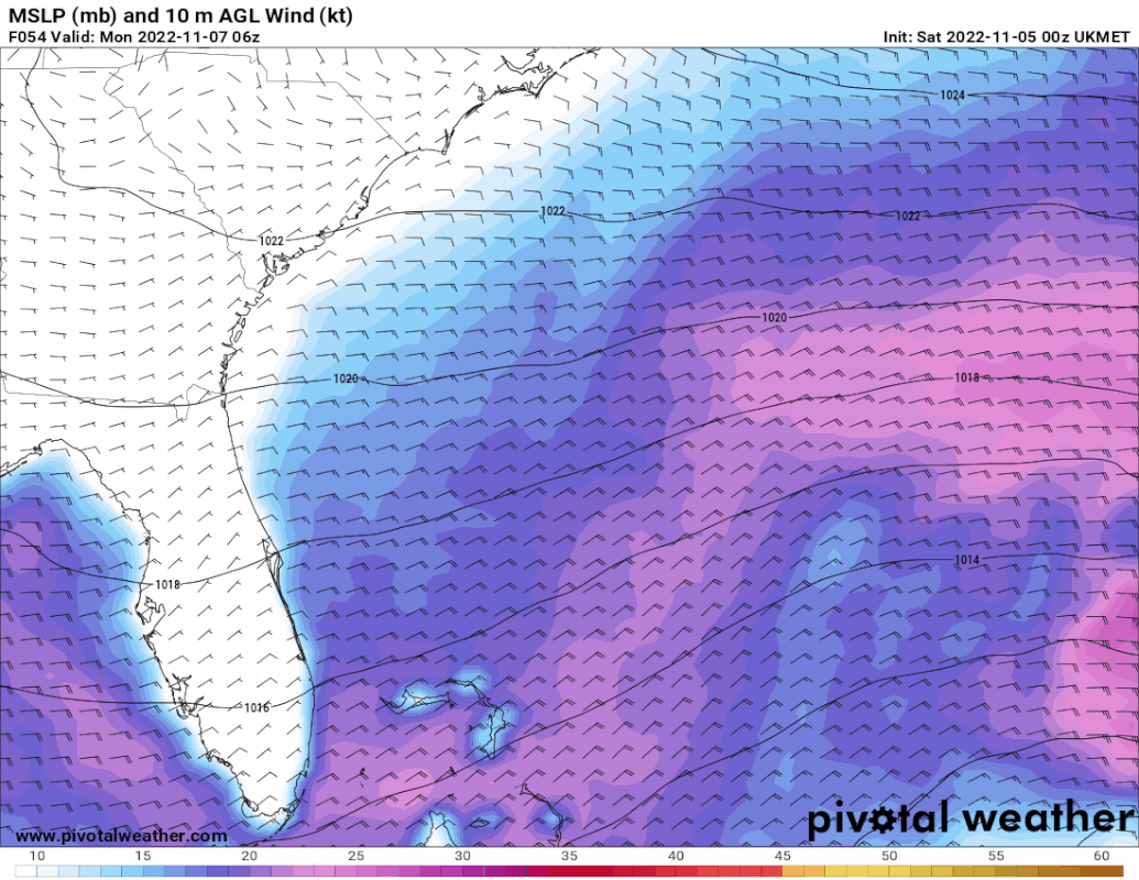
00z Ukmet
0 likes
Hurricane Eye Experience: David 79, Irene 99, Frances 04, Jeanne 04, Wilma 05… Hurricane Brush Experience: Andrew 92, Erin 95, Floyd 99, Matthew 16, Irma 17, Ian 22, Nicole 22…

Re: Possible Development Near the GA/Bahamas Early Next Week (10/60)
Shear-induced convection firing south of Hispaniola.
Right on schedule
Right on schedule
0 likes
Who is online
Users browsing this forum: hurricanes1234, WaveBreaking and 166 guests