Fair enough again; but still not the certifiably lowest pressure AND if you'll note that by this time the storm was indeed in rapid decline... the very NEXT advisory after this shows top winds of 115 kt.. with the pressure having risen only 10 mb higher. These are clearly not even remotely evidence that you have a landfalling 5 above 935... again, however, I reiterate what I stated now on three occassions... I don't believe it's "impossible"... but it certainly isn't "easy" as was claimed... and that Hugo was decidedly not one of them.
A2K
Cat 4 hurricanes very unlikely north of Florida on E Coast
Moderator: S2k Moderators
Forum rules

The posts in this forum are NOT official forecasts and should not be used as such. They are just the opinion of the poster and may or may not be backed by sound meteorological data. They are NOT endorsed by any professional institution or STORM2K. For official information, please refer to products from the National Hurricane Center and National Weather Service.
-
Audrey2Katrina

- Category 5

- Posts: 4252
- Age: 76
- Joined: Fri Dec 23, 2005 10:39 pm
- Location: Metaire, La.
0 likes
Flossy 56 Audrey 57 Hilda 64* Betsy 65* Camille 69* Edith 71 Carmen 74 Bob 79 Danny 85 Elena 85 Juan 85 Florence 88 Andrew 92*, Opal 95, Danny 97, Georges 98*, Isidore 02, Lili 02, Ivan 04, Cindy 05*, Dennis 05, Katrina 05*, Gustav 08*, Isaac 12*, Nate 17, Barry 19, Cristobal 20, Marco, 20, Sally, 20, Zeta 20*, Claudette 21 IDA* 21 Francine *24

I totally agree Audery it seems clear that Allen was in its weaken phase at that point, though the next adviosary may well be exaplained by Eyewall replacement, sounds like it to me anyway. It certainly isn't easy and I'd guess it has the same chances of happenign as a storm getting below say 890mbs in the Atlantic.
0 likes
Personal Forecast Disclaimer:
The posts in this forum are NOT official forecast and should not be used as such. They are just the opinion of the poster and may or may not be backed by sound meteorological data. They are NOT endorsed by any professional institution or storm2k.org. For official information, please refer to the NHC and NWS products
The posts in this forum are NOT official forecast and should not be used as such. They are just the opinion of the poster and may or may not be backed by sound meteorological data. They are NOT endorsed by any professional institution or storm2k.org. For official information, please refer to the NHC and NWS products
-
dwsqos2
Another Potential High Latitude Category 5
The wind speeds in Isabel's TCR are given in knots ( i.e. 69 KT, 55 KT ); however, this does not change much. Also, although the value was unofficial, a private weather station in New Bern recorded a sustained wind of 80 KT [1], and although this is below the accepted 1-minute 10 m winds at landfall, taking reduction due to friction into account, it is not inconsistent with the 90 KT assessed in best track.
Additionally, it is interesting to note, that at 1753 UTC 13 September, a dropsonde recorded a maximum of 203 KT at 806 mb [1]. Even after the 2005 and 2004 hurricane seasons, this stands as the strongest wind ever observed in a tropical cyclone. Moreover, Isabel's intensity at the time of this extreme observation was 932 mb/140 KT [1]. However, Isabel, despite this and despite being a sizable hurricane, is probably not the best example of a category 5 hurricane with a high minimum central pressure, given that this extreme intensity occurred at a far more southern latitude than the hurricane under consideration.
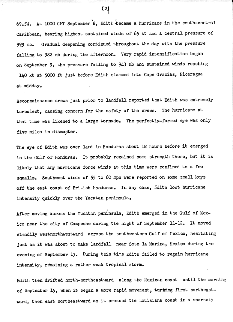
Moreover, to consider at least one of KWT's examples, Edith, following its reanalysis, probably will not retain category 5 intensity. For in Edith's Preliminary Report, it is noted that "sustained winds [reached] 140 KT at 5000 feet just before Edith slammed into Cape Gracias, Nicaragua later that day" [2]. Using the accepted reduction factor for such an altitude of 0.80, the observed winds are suggestive of 1-minute 10 m wind of 112 KT; that is, Edith's landfall intensity could be reduced to category 3.
However, regardless of these examples, if one wants a hurricane that potentially was a category 5 with a minimum central pressure greater than 934 mb, then one should consider hurricane Gladys of 1975. In the paper "Atlantic Hurricane Season of 1975," it is noted that "Air Force reconnaissance [measured a] minimum central pressure of 939 mb at 0846 GMT 2 October" [3, p. 11]. Occurring concurrently was the measurement of 700 mb winds as high as 169 KT [3,p. 11]. Using the time given and Gladys' best track, it follows that the measurement of the pressure and winds occurred between 32.9N and 35.3N [4]; the accepted latitude of Hugo's landfall is 32.8N [5]. If one assumes that the peak wind represents a 10-second average, then applying the standard 0.90 reduction factor to this value yields a 1-minute 10 m wind of 152 KT. In order to obtain Gladys' maximum intensity in best track, a reduction factor of 0.71 must be applied.
As a caveat, one might argue that the 169 KT value does not represent a 10-second wind; rather, it might have potentially been a 1-second wind. In this case the appropriate reduction factor is a complete mystery to this poster. However, it probably guarantees that the 10-second wind exceeded 150 KT. Also, given Gladys' recurvature and acceleration, baroclinic influences are likely a given, and consequently a lower reduction factor might be appropriate. Obviously, many of the above musings of the complete novice are based entirely upon mathematical inference, so please feel free to toy away, tear apart, and toss aside.
[1]http://www.nhc.noaa.gov/2003isabel.shtml?
[2]http://www.nhc.noaa.gov/archive/storm_wallets/atlantic/atl1971-prelim/edith/prelim02.gif
[3]http://www.aoml.noaa.gov/general/lib/lib1/nhclib/1975.pdf
[4]http://weather.unisys.com/hurricane/atlantic/1975/GLADYS/track.dat
[5]http://www.nhc.noaa.gov/archive/storm_wallets/atlantic/atl1989-prelim/hugo/prelim07.gif
Additionally, it is interesting to note, that at 1753 UTC 13 September, a dropsonde recorded a maximum of 203 KT at 806 mb [1]. Even after the 2005 and 2004 hurricane seasons, this stands as the strongest wind ever observed in a tropical cyclone. Moreover, Isabel's intensity at the time of this extreme observation was 932 mb/140 KT [1]. However, Isabel, despite this and despite being a sizable hurricane, is probably not the best example of a category 5 hurricane with a high minimum central pressure, given that this extreme intensity occurred at a far more southern latitude than the hurricane under consideration.
Moreover, to consider at least one of KWT's examples, Edith, following its reanalysis, probably will not retain category 5 intensity. For in Edith's Preliminary Report, it is noted that "sustained winds [reached] 140 KT at 5000 feet just before Edith slammed into Cape Gracias, Nicaragua later that day" [2]. Using the accepted reduction factor for such an altitude of 0.80, the observed winds are suggestive of 1-minute 10 m wind of 112 KT; that is, Edith's landfall intensity could be reduced to category 3.
However, regardless of these examples, if one wants a hurricane that potentially was a category 5 with a minimum central pressure greater than 934 mb, then one should consider hurricane Gladys of 1975. In the paper "Atlantic Hurricane Season of 1975," it is noted that "Air Force reconnaissance [measured a] minimum central pressure of 939 mb at 0846 GMT 2 October" [3, p. 11]. Occurring concurrently was the measurement of 700 mb winds as high as 169 KT [3,p. 11]. Using the time given and Gladys' best track, it follows that the measurement of the pressure and winds occurred between 32.9N and 35.3N [4]; the accepted latitude of Hugo's landfall is 32.8N [5]. If one assumes that the peak wind represents a 10-second average, then applying the standard 0.90 reduction factor to this value yields a 1-minute 10 m wind of 152 KT. In order to obtain Gladys' maximum intensity in best track, a reduction factor of 0.71 must be applied.
As a caveat, one might argue that the 169 KT value does not represent a 10-second wind; rather, it might have potentially been a 1-second wind. In this case the appropriate reduction factor is a complete mystery to this poster. However, it probably guarantees that the 10-second wind exceeded 150 KT. Also, given Gladys' recurvature and acceleration, baroclinic influences are likely a given, and consequently a lower reduction factor might be appropriate. Obviously, many of the above musings of the complete novice are based entirely upon mathematical inference, so please feel free to toy away, tear apart, and toss aside.
[1]http://www.nhc.noaa.gov/2003isabel.shtml?
[2]http://www.nhc.noaa.gov/archive/storm_wallets/atlantic/atl1971-prelim/edith/prelim02.gif
[3]http://www.aoml.noaa.gov/general/lib/lib1/nhclib/1975.pdf
[4]http://weather.unisys.com/hurricane/atlantic/1975/GLADYS/track.dat
[5]http://www.nhc.noaa.gov/archive/storm_wallets/atlantic/atl1989-prelim/hugo/prelim07.gif
0 likes
-
wxman57

- Moderator-Pro Met

- Posts: 23131
- Age: 68
- Joined: Sat Jun 21, 2003 8:06 pm
- Location: Houston, TX (southwest)
Audrey2Katrina wrote:Camille hit nearly the same point as Katrina, but it approached the coast from the southeast rather than from the south. This greatly reduced the storm surge west of the track.
But wouldn't that have greatly "increased" the storm surge "east" of the track? I can assure you that the Mobile area did not get the surge from Camille, that she did from Katrina.
One could argue the vaguary or "nearly" but I believe Camille hit some 10 or 20 miles to the east, but that's admittedly a guess, perhaps statistically insignificant; on the other hand, Camille's approach to the coast was not all that different from Katrina's in the last couple of hundred of miles of approach. In looking at the track, if anything, Camille came from a much more "southern" approach than did Katrina, which came from a much more overall "eastern" direction... it was that last hundred or so miles of approach that mattered, and in this, they really are not all that different. The bottom line is that Katrina was MUCH bigger than Camille, with the latter having MUCH tighter intensity--and as you aptly suggested, the swath of the wind field created Katrina's much worse surge. Had Camille been the size of Katrina, the surge damage would have been very similar in the size of the swath of devastation, and in this category, there isn't a remote comparison as Katrina inundated practically from the Ala/Florida border well into SE Louisiana.
A2K
I believe there were a severalreasons for Camille's lower and less extensive surge.
1. Though Camille wasn't tiny, its radius of max winds were considerably smaller than Katrina's. Therefore, the surge did not extend as far to the right of the track.
2. Katrina had a larger wind field (radius of max winds) than Camille and it was accelerating to a speed which nearly matched the velocity of the very large waves it was generating (trapped fetch waves). So Katrina produced maximum waves of 75-85 feet, likely a good bit higher than Camille's waves and covering a much larger area.
3. Katrina was moving on a path that drove very large waves to the NW into the SE LA delta. This onshore flow ahead of landfall produced a setup tide of 6-8 feet prior to the arrival of the center. With Camille, NE winds ahead of landfall actually resulted in tides 3-5 feet below normal prior to the arrival of the center.
4. Camille's core of max winds passed well east of downtown New Orleans.
I believe that the above reasons are why Camille caused less of a problem in the New Orleans area. Tides/surge were not as high west of Camille's track and winds were lower in New Orleans. The levees held for Camille.
0 likes
-
Audrey2Katrina
- Category 5
- Posts: 4252
- Age: 76
- Joined: Fri Dec 23, 2005 10:39 pm
- Location: Metaire, La.
a dropsonde recorded a maximum of 203 KT at 806 mb
Well, it also concedes this was almost certainly a "gust" and not a 1m sustained windspeed. Additionally, I am confident that greater speeds have been recorded in dropsondes since that time--nonetheless the information is intriguing.
Incidentally; on the Isabel note, I have had the good fortune to communicate directly with one of the mets who prepared that report... and he suggests two things he feels very confident of: 1.) Isabel was a much SMALLER (hence "intense" gradient) storm when it was a 5 than it was at landfall... AND, that 2.) He is very firmly of he belief that Hugo was definitely not more than a 4 at landfall.
A2K
0 likes
Flossy 56 Audrey 57 Hilda 64* Betsy 65* Camille 69* Edith 71 Carmen 74 Bob 79 Danny 85 Elena 85 Juan 85 Florence 88 Andrew 92*, Opal 95, Danny 97, Georges 98*, Isidore 02, Lili 02, Ivan 04, Cindy 05*, Dennis 05, Katrina 05*, Gustav 08*, Isaac 12*, Nate 17, Barry 19, Cristobal 20, Marco, 20, Sally, 20, Zeta 20*, Claudette 21 IDA* 21 Francine *24
-
Audrey2Katrina
- Category 5
- Posts: 4252
- Age: 76
- Joined: Fri Dec 23, 2005 10:39 pm
- Location: Metaire, La.
Wxman57, there's not much, if anything I would dispute in the last post... seems very logical to me. BTW, I didn't call Camille "tiny"... but decidedly smaller than Katrina.
A2K
A2K
0 likes
Flossy 56 Audrey 57 Hilda 64* Betsy 65* Camille 69* Edith 71 Carmen 74 Bob 79 Danny 85 Elena 85 Juan 85 Florence 88 Andrew 92*, Opal 95, Danny 97, Georges 98*, Isidore 02, Lili 02, Ivan 04, Cindy 05*, Dennis 05, Katrina 05*, Gustav 08*, Isaac 12*, Nate 17, Barry 19, Cristobal 20, Marco, 20, Sally, 20, Zeta 20*, Claudette 21 IDA* 21 Francine *24

In Isabel we had a pressure here in Greenville NC of 970MB which is a CAT 2 pressure, for example Hurricane Juan that year was a 105 MPH hurricane and the lowest pressure recorded in that hurricane as 969mb. During Isabel we did not even have a gust much over 50 MPH here in Greenville however to our northeast Elizabeth City NC where the lowest pressure was 981.5mb they had winds well over hurricane force in gust and sustained winds over 50 mph.
0 likes
-
MGC

- S2K Supporter

- Posts: 5938
- Joined: Sun Mar 23, 2003 9:05 pm
- Location: Pass Christian MS, or what is left.
Yes, Camille's core of winds were relativly small. In New Orleans East, where we road out Camille (imagine not evacuation for Camille, what were my parents thinking?) winds were only up to Cat-1 strength. I even doubt my parents house saw Cat-1 winds during Camille. Winds were way lower at the house in NO East during Camille than during Betsy. Betsy & Katrina uprooted many trees, Camille didn't......MGC
0 likes

Audrey2Katrina wrote:a dropsonde recorded a maximum of 203 KT at 806 mb
Well, it also concedes this was almost certainly a "gust" and not a 1m sustained windspeed. Additionally, I am confident that greater speeds have been recorded in dropsondes since that time--nonetheless the information is intriguing.
Incidentally; on the Isabel note, I have had the good fortune to communicate directly with one of the mets who prepared that report... and he suggests two things he feels very confident of: 1.) Isabel was a much SMALLER (hence "intense" gradient) storm when it was a 5 than it was at landfall... AND, that 2.) He is very firmly of he belief that Hugo was definitely not more than a 4 at landfall.
A2K
I have never come across a reputable meteorologist who believes that Hugo was a Cat 5 at landfall. Any evidence provided in this thread so far is marginal at best.
0 likes
-
Audrey2Katrina
- Category 5
- Posts: 4252
- Age: 76
- Joined: Fri Dec 23, 2005 10:39 pm
- Location: Metaire, La.
who believes that Hugo was a Cat 5 at landfall. Any evidence provided in this thread so far is marginal at best
I completely agree.
A2K
0 likes
Flossy 56 Audrey 57 Hilda 64* Betsy 65* Camille 69* Edith 71 Carmen 74 Bob 79 Danny 85 Elena 85 Juan 85 Florence 88 Andrew 92*, Opal 95, Danny 97, Georges 98*, Isidore 02, Lili 02, Ivan 04, Cindy 05*, Dennis 05, Katrina 05*, Gustav 08*, Isaac 12*, Nate 17, Barry 19, Cristobal 20, Marco, 20, Sally, 20, Zeta 20*, Claudette 21 IDA* 21 Francine *24
-
Sean in New Orleans

- Category 5
- Posts: 1794
- Joined: Thu Aug 28, 2003 7:26 pm
- Location: New Orleans, LA 30.0N 90.0W
- Contact:
Derek Ortt wrote:not that I am surprised by the Jaggar and Elsner study, as the only cat 4 hurricane that I know of to hit the EC north of Florida was Hugo
Not that the EC should not take major hurricanes seriously, as the return period of cat 3's is much more frequent and as we saw last year, cat 3's are very destructive events
Cat. 3 storms are destructive, but, Cat. 5 storm surges, no matter what the wind speed of the system is what really wreaks the havoc and death. Considering, that Katrina had 10 feet higher storm surge than any in recorded history, I think it's easy to see why this is the largest, most damaging meteorological tropical event since record keeping began. We've cleaned up over 8X the debris Andrew left behind in Florida, already, and not even half of our debris has been picked up yet! It's truly unreal isn't it?!
0 likes
You know, I remember the last time Derek posted something that almost everyone on this board disagreed with. It turned into a 40-plus page topic... yes, I'm talking about some data that indicated Katrina might have been a category 3 at landfall instead of a category 4. And -- you guessed it -- the NHC later said in its post-storm report that Katrina was indeed a cat 3 at landfall.
I'm not saying that Hugo was a category 5. It probably wasn't, based on the statistics that were supposed to be the topic of this thread. Derek hasn't even unequivocally stated that himself; he's simply said that he thinks the chances are greater than most people believe. But I've doubted him before and I turned out to be wrong. I'd think twice before questioning his credibility or reputation.
I'm not saying that Hugo was a category 5. It probably wasn't, based on the statistics that were supposed to be the topic of this thread. Derek hasn't even unequivocally stated that himself; he's simply said that he thinks the chances are greater than most people believe. But I've doubted him before and I turned out to be wrong. I'd think twice before questioning his credibility or reputation.
0 likes
mtm4319 wrote:You know, I remember the last time Derek posted something that almost everyone on this board disagreed with. It turned into a 40-plus page topic... yes, I'm talking about some data that indicated Katrina might have been a category 3 at landfall instead of a category 4. And -- you guessed it -- the NHC later said in its post-storm report that Katrina was indeed a cat 3 at landfall.
I'm not saying that Hugo was a category 5. It probably wasn't, based on the statistics that were supposed to be the topic of this thread. Derek hasn't even unequivocally stated that himself; he's simply said that he thinks the chances are greater than most people believe. But I've doubted him before and I turned out to be wrong. I'd think twice before questioning his credibility or reputation.
What is Derek's reputation in the eyes of those on this board?
0 likes
-
Sean in New Orleans
- Category 5
- Posts: 1794
- Joined: Thu Aug 28, 2003 7:26 pm
- Location: New Orleans, LA 30.0N 90.0W
- Contact:
mtm4319 wrote:You know, I remember the last time Derek posted something that almost everyone on this board disagreed with. It turned into a 40-plus page topic... yes, I'm talking about some data that indicated Katrina might have been a category 3 at landfall instead of a category 4. And -- you guessed it -- the NHC later said in its post-storm report that Katrina was indeed a cat 3 at landfall.
I'm not saying that Hugo was a category 5. It probably wasn't, based on the statistics that were supposed to be the topic of this thread. Derek hasn't even unequivocally stated that himself; he's simply said that he thinks the chances are greater than most people believe. But I've doubted him before and I turned out to be wrong. I'd think twice before questioning his credibility or reputation.
Katrina was a category 3...that's one thing that I won't deny...we only had sustained 120mph winds in New Orleans with gusts to 135mph to 140 mph...but, that baby, came with a Cat. 5 storm surge and nobody is denying that...I really think that, after what happened last year, with Katrina, the NHC should offer two forecasts...one forecast would categorize the winds and another would categorize the surge. It would keep things much clearer for people. For people to think that Katrina was a category 3 is somewhat misleading because that refers only to winds...people don't think about a 30+ foot storm surge when they think of a category 3 hurricane...at least I don't.
0 likes
-
Audrey2Katrina
- Category 5
- Posts: 4252
- Age: 76
- Joined: Fri Dec 23, 2005 10:39 pm
- Location: Metaire, La.
I'm not saying that Hugo was a category 5. It probably wasn't, based on the statistics that were supposed to be the topic of this thread. Derek hasn't even unequivocally stated that himself; he's simply said that he thinks the chances are greater than most people believe. But I've doubted him before and I turned out to be wrong. I'd think twice before questioning his credibility or reputation.
Number 1: There were questions about Katrina's actual landfalling intensity quite some time ago. It was being vociferously debated as to whether it was a 3, 4, or 5 on boards all over the net--I'd been to quite a few; many foresaw a 3 landfall well before the report was issued--to his credit, Mr. Ortt was one of this number... it just didn't become official until the release of the NHC report, and just in the name of "equal time", while that is the "official" record of date, it does not make it "gospel"... as there remain plenty pro-mets around the country to this day, including some who flew into Katrina, who still feel this may well have been a rush to judgment--don't want to go there again--another dead horse--just making a point that there were many disputing Katrina's landfall intensity before the report--this is not to credit or discredit anyone--only to place it in a more proper context.
Number 2. Indeed, Hugo probably wasn't a Cat 5, even among the very mets working for the TPC who WROTE the Isabel report do not think this likely at all. I would not hold my breath waiting on any such reclassification--won't happen.
As far as Mr. Ortt's credibility or reputation is concerned, I know of no one attempting to convey a slur on either of those simply by disagreeing. Why is it that when one voices a disagreement, that to some this is miraculously morphed into an attack on their reputation or credibility. Heck, meteorologists disagree among THEMSELVES all the time--and this is not to be perceived as an attack on anyone's credibility, or reputation. Now were I to start doing searches, and citing this or that instance where he, or anyone else has been habitually wrong--well then one might justifiably assume that I would be attempting to present a case attacking credibility--but that clearly is not the case here. It is merely a point of respectful disagreement and the two are mutually EXCLUSIVE.
I've said it before, and I'll say it again. I have great respect for ANY professional meteorologist, and certainly will give their viewpoints just consideration; likewise I do not see the need to bend a knee at the altar of someone because they are a pro-met as having any sort of neo-papal infallibility. Like all other "pros" they are subject to the foibles and viscissitudes of human nature--it's just that they know a heck of a lot more about weather than pretty much all the rest of us laymen!
A2K
0 likes
-
Opal storm
N.O didn't get the cat 3 winds,mostly cat 1 conditions.Sean in New Orleans wrote:mtm4319 wrote:You know, I remember the last time Derek posted something that almost everyone on this board disagreed with. It turned into a 40-plus page topic... yes, I'm talking about some data that indicated Katrina might have been a category 3 at landfall instead of a category 4. And -- you guessed it -- the NHC later said in its post-storm report that Katrina was indeed a cat 3 at landfall.
I'm not saying that Hugo was a category 5. It probably wasn't, based on the statistics that were supposed to be the topic of this thread. Derek hasn't even unequivocally stated that himself; he's simply said that he thinks the chances are greater than most people believe. But I've doubted him before and I turned out to be wrong. I'd think twice before questioning his credibility or reputation.
Katrina was a category 3...that's one thing that I won't deny...we only had sustained 120mph winds in New Orleans with gusts to 135mph to 140 mph...but, that baby, came with a Cat. 5 storm surge and nobody is denying that...I really think that, after what happened last year, with Katrina, the NHC should offer two forecasts...one forecast would categorize the winds and another would categorize the surge. It would keep things much clearer for people. For people to think that Katrina was a category 3 is somewhat misleading because that refers only to winds...people don't think about a 30+ foot storm surge when they think of a category 3 hurricane...at least I don't.
0 likes
-
Audrey2Katrina
- Category 5
- Posts: 4252
- Age: 76
- Joined: Fri Dec 23, 2005 10:39 pm
- Location: Metaire, La.
What is Derek's reputation in the eyes of those on this board?
That should not even be an issue, or discussed! He's a professional meteorologist, and should be respected as such. This does not mean unflagging devotion to every utterance he makes, any more than my students owe me unflagging devotion to every vocalization I make in a classroom... we are, after all, humans--professionals in our respective fields and respected as such--but decidedly: Human!
A2K
0 likes
Flossy 56 Audrey 57 Hilda 64* Betsy 65* Camille 69* Edith 71 Carmen 74 Bob 79 Danny 85 Elena 85 Juan 85 Florence 88 Andrew 92*, Opal 95, Danny 97, Georges 98*, Isidore 02, Lili 02, Ivan 04, Cindy 05*, Dennis 05, Katrina 05*, Gustav 08*, Isaac 12*, Nate 17, Barry 19, Cristobal 20, Marco, 20, Sally, 20, Zeta 20*, Claudette 21 IDA* 21 Francine *24
-
Audrey2Katrina
- Category 5
- Posts: 4252
- Age: 76
- Joined: Fri Dec 23, 2005 10:39 pm
- Location: Metaire, La.
Katrina was a category 3...that's one thing that I won't deny...
And I respect that viewpoint... as for me... I'm still open to the probability of a 4 at initial landfall--just not enough data IMO... but I REALLY don't want to re-open that can of worms, I just had to say that I feel opinions vary widely on this issue--especially at first landfall.... that said, I respect your opinion.
A2K
0 likes
Flossy 56 Audrey 57 Hilda 64* Betsy 65* Camille 69* Edith 71 Carmen 74 Bob 79 Danny 85 Elena 85 Juan 85 Florence 88 Andrew 92*, Opal 95, Danny 97, Georges 98*, Isidore 02, Lili 02, Ivan 04, Cindy 05*, Dennis 05, Katrina 05*, Gustav 08*, Isaac 12*, Nate 17, Barry 19, Cristobal 20, Marco, 20, Sally, 20, Zeta 20*, Claudette 21 IDA* 21 Francine *24
-
Audrey2Katrina
- Category 5
- Posts: 4252
- Age: 76
- Joined: Fri Dec 23, 2005 10:39 pm
- Location: Metaire, La.
N.O didn't get the cat 3 winds,mostly cat 1 conditions
Boy did I EVER see this coming! NO East Got at least Cat 2 winds... officially! Remember New Orleans extends all the way to practically the Mississippi line where Katrina made landfall---moot point---dead horse *sigh*
A2K
0 likes
Flossy 56 Audrey 57 Hilda 64* Betsy 65* Camille 69* Edith 71 Carmen 74 Bob 79 Danny 85 Elena 85 Juan 85 Florence 88 Andrew 92*, Opal 95, Danny 97, Georges 98*, Isidore 02, Lili 02, Ivan 04, Cindy 05*, Dennis 05, Katrina 05*, Gustav 08*, Isaac 12*, Nate 17, Barry 19, Cristobal 20, Marco, 20, Sally, 20, Zeta 20*, Claudette 21 IDA* 21 Francine *24
-
gatorcane

- S2K Supporter
- Posts: 23703
- Age: 47
- Joined: Sun Mar 13, 2005 3:54 pm
- Location: Boca Raton, FL
Audrey2Katrina wrote:N.O didn't get the cat 3 winds,mostly cat 1 conditions
Boy did I EVER see this coming! NO East Got at least Cat 2 winds... officially! Remember New Orleans extends all the way to practically the Mississippi line where Katrina made landfall---moot point---dead horse *sigh*
A2K
The bottom-line is that CAT 4+ hurricanes are very rare north of Florida and even the northern GOM. I did state my reasons earlier up on this thread.
It is very easy to mistaken a CAT 1-2 wind of 100 mph+ with CAT 3+ winds if you never have been through CAT 3+ winds. For example, many areas of South Florida only received CAT 1-2 winds from Wilma although people insisted they had been through a major hurricane - NOT TRUE!
I think Derek has it nailed no matter how you analyze it folks. Unfortunately South Florida is a ticking timebomb waiting to go off - I just hope it is not anytime soon.
Last edited by gatorcane on Sat Jul 08, 2006 7:41 pm, edited 1 time in total.
0 likes
Who is online
Users browsing this forum: No registered users and 38 guests