Analysis,Models,Sat Pics of Low in Western Atlantic

This is the general tropical discussion area. Anyone can take their shot at predicting a storms path.

Moderator: S2k Moderators

Forum rules

The posts in this forum are NOT official forecasts and should not be used as such. They are just the opinion of the poster and may or may not be backed by sound meteorological data. They are NOT endorsed by any professional institution or STORM2K. For official information, please refer to products from the National Hurricane Center and National Weather Service.

Help Support Storm2K
Message
Author
User avatar
cycloneye
Admin
Admin
Posts: 143867
Age: 68
Joined: Thu Oct 10, 2002 10:54 am
Location: San Juan, Puerto Rico

#101 Postby cycloneye » Sat May 05, 2007 5:31 pm

canegrl04 wrote:I'm not too surprised.Its been pretty da**ed warm and steamy in Texas now for the past week.Next week will be no exception.Conditions ae right for something to develope in th GOM.Even if its just a TS,it could do great damage.Remeber Allison in 2003? :eek:


This low of cold core origin will not be in the Gulf of Mexico,but off the East Coast of the U.S.
0 likes   
Visit the Caribbean-Central America Weather Thread where you can find at first post web cams,radars
and observations from Caribbean basin members Click Here

User avatar
brunota2003
S2K Supporter
S2K Supporter
Posts: 9476
Age: 34
Joined: Sat Jul 30, 2005 9:56 pm
Location: Stanton, KY...formerly Havelock, NC
Contact:

#102 Postby brunota2003 » Sat May 05, 2007 5:34 pm

fact789 wrote:Is this it or is it not there yet?

That little blob of lowpressure off of SC that looks completely harmless right now? Yep...thats it...here over the next 24 hours it is going to transform into something...bad...
0 likes   

User avatar
Tampa Bay Hurricane
Category 5
Category 5
Posts: 5597
Age: 37
Joined: Fri Jul 22, 2005 7:54 pm
Location: St. Petersburg, FL

#103 Postby Tampa Bay Hurricane » Sat May 05, 2007 5:53 pm

Whoaa...my bet is we see a strong tropical storm out
of this.
-reduced shear
-hot gulf stream waters
-moisture
= KaBOOM for a warmcore low
I'd say this system hits 70 mph
sustained winds with gusts to 90
mph by thursday or friday
0 likes   

Opal storm

#104 Postby Opal storm » Sat May 05, 2007 5:56 pm

I'm not buying into the hype yet, I'll believe it when I see it.
0 likes   

User avatar
brunota2003
S2K Supporter
S2K Supporter
Posts: 9476
Age: 34
Joined: Sat Jul 30, 2005 9:56 pm
Location: Stanton, KY...formerly Havelock, NC
Contact:

#105 Postby brunota2003 » Sat May 05, 2007 5:58 pm

Opal storm wrote:I'm not buying into the hype yet, I'll believe it when I see it.
Same, but it is interesting to see the model runs and possiblities into it...Sadly, looks like I'll be dealing with this storm twice, if it does loop back around O.o
0 likes   

User avatar
cycloneye
Admin
Admin
Posts: 143867
Age: 68
Joined: Thu Oct 10, 2002 10:54 am
Location: San Juan, Puerto Rico

#106 Postby cycloneye » Sat May 05, 2007 6:04 pm

18z GFS Loop

:uarrow: :uarrow: :uarrow:

In this 18z GFS run,this model deepens the low down to 1001 mbs while it moves it slowly towards the coast but does not get more closer.Later in the loop interesting stuff appears in the Caribbean moving northward.
0 likes   
Visit the Caribbean-Central America Weather Thread where you can find at first post web cams,radars
and observations from Caribbean basin members Click Here

User avatar
Tampa Bay Hurricane
Category 5
Category 5
Posts: 5597
Age: 37
Joined: Fri Jul 22, 2005 7:54 pm
Location: St. Petersburg, FL

#107 Postby Tampa Bay Hurricane » Sat May 05, 2007 6:04 pm

I know I've been hyping a lot more than I normally would, but
the environmental conditions are going to be very conducive
for the formation of a potent tropical storm by next week
with low shear, moisture, warm gulf stream waters...the surface
low that forms is going to take advantage of these factors
(moisture, oceanic heat content) and intensify to likely
a potent tropical storm. The global models
back this up with many indicating a 996 mb surface
warm core low which would be a moderate tropical
storm.
0 likes   

User avatar
Tampa Bay Hurricane
Category 5
Category 5
Posts: 5597
Age: 37
Joined: Fri Jul 22, 2005 7:54 pm
Location: St. Petersburg, FL

#108 Postby Tampa Bay Hurricane » Sat May 05, 2007 6:08 pm

We could also see some action in the Caribbean according to the latest GFS run.
0 likes   

User avatar
NDG
S2K Supporter
S2K Supporter
Posts: 15446
Joined: Sun Jul 09, 2006 10:14 pm
Location: Orlando, FL

#109 Postby NDG » Sat May 05, 2007 6:48 pm

Tampa Bay Hurricane wrote:We could also see some action in the Caribbean according to the latest GFS run.


The GFS has been insisting in some development in the southcentral Caribbean for the past 10 days or so for the end of next week, but so far no other global model has jumped on board with the GFS, even for the last day or so the GFS has become inconsistant on the formation of an organized low pressure down there, one problem is the very low pressure forming off the SE US coast, which was not forecasted by the GFS until a few days ago, will keep shear high in the caribbean longer through at least the end of next week.
0 likes   

cpdaman
Category 5
Category 5
Posts: 3131
Joined: Sat Jun 10, 2006 11:44 am
Location: SPB county (gulf stream)

#110 Postby cpdaman » Sat May 05, 2007 6:50 pm

boaters in the gulf stream take note all the way down into broward county florida seas are forecast to be 12 to as high as 15 feet in the gulf stream late mon and tuesday
0 likes   

User avatar
cycloneye
Admin
Admin
Posts: 143867
Age: 68
Joined: Thu Oct 10, 2002 10:54 am
Location: San Juan, Puerto Rico

#111 Postby cycloneye » Sat May 05, 2007 7:45 pm

A reminder that if and it's a big if,invest 90L pops up for the low pressure,a new thread will be made.
0 likes   

User avatar
HURAKAN
Professional-Met
Professional-Met
Posts: 46086
Age: 38
Joined: Thu May 20, 2004 4:34 pm
Location: Key West, FL
Contact:

#112 Postby HURAKAN » Sat May 05, 2007 7:55 pm

cycloneye wrote:A reminder that if and it's a big if,invest 90L pops up for the low pressure,a new thread will be made.


In tropical meteorology we live of "ifs"!!!
Last edited by HURAKAN on Sat May 05, 2007 7:59 pm, edited 1 time in total.
0 likes   

User avatar
cycloneye
Admin
Admin
Posts: 143867
Age: 68
Joined: Thu Oct 10, 2002 10:54 am
Location: San Juan, Puerto Rico

#113 Postby cycloneye » Sat May 05, 2007 7:59 pm

LONG TERM /MONDAY THROUGH SATURDAY/...A POTENTIALLY SIGNIFICANT
COASTAL STORM MAY IMPACT THE RGN THIS WEEK BRINGING A VARIETY OF
HAZARDS THE PARTS OF THE AREA INCLUDING HIGH WINDS...DANGEROUS
SURF...STRONG RIP CURRENTS AND BEACH EROSION. ALL OF THE MODELS ARE
IN GENERAL AGREEMENT THAT FRONTAL CYCLOGENESIS WL OCCUR OFF THE
SC/NC COAST LTE TNGT INTO SUN AS THE SUPPORTING UPR TROF DIGS DOWN
THE ERN SEABOARD AND EVENTUALLY CUTS OFF JUST E OF CAPE HATTERAS.
THE 05/12Z GFS IS SIMILAR TO ITS PREVIOUS RUNS IN BEING THE ERN MOST
OUTLIER OF THE VARIOUS MODEL PKGS WITH THE ECMWF LOOKING MORE
REASONABLE AT THIS JUNCTURE. THIS TRACK WOULD RETROGRADE THE SFC LOW
CLOSER TO THE GA/SC COAST WITH THE LOW BEING CNTRD ABT 200 E OF SAV
BY THE END OF THE WEEK. THIS TRACK IS VERY CLOSE TO THE LATEST
MANUAL HPC PROGS. OBVIOUSLY THE EVENTUAL IMPACTS FROM THIS SYSTEM WL
BE HIGHLY DEPENDANT ON THE EVENTUAL MOVEMENT AND STRENGTH OF THE SFC
LOW AND THE STRENGTH OF THE RIDGE TO THE N OF THE SYSTEM.
COMPLICATING MATTERS IS THAT THERE ARE SIGNALS IN THE VARIOUS MODELS
THAT THIS SYSTEM COULD BECOME A SUBTROPICAL STORM OR SUBTROPICAL
DEPRESSION HYBRID...WHICH IS FURTHER SUPPORTED BY PHASE DIAGRAMS OUT
OF FSU.

http://www.erh.noaa.gov/displayprod.php ... =CAEAFDCHS

Above is the discussion from the Charleston NWS office.
0 likes   
Visit the Caribbean-Central America Weather Thread where you can find at first post web cams,radars
and observations from Caribbean basin members Click Here

User avatar
Nimbus
Category 5
Category 5
Posts: 5274
Joined: Mon Jul 19, 2004 10:54 am

#114 Postby Nimbus » Sat May 05, 2007 8:05 pm

A retrograding hybrid storm going warm core under that southeastern ridge?

Is this the first actual forecast this year for a warm core system?
0 likes   

User avatar
HURAKAN
Professional-Met
Professional-Met
Posts: 46086
Age: 38
Joined: Thu May 20, 2004 4:34 pm
Location: Key West, FL
Contact:

#115 Postby HURAKAN » Sat May 05, 2007 8:17 pm

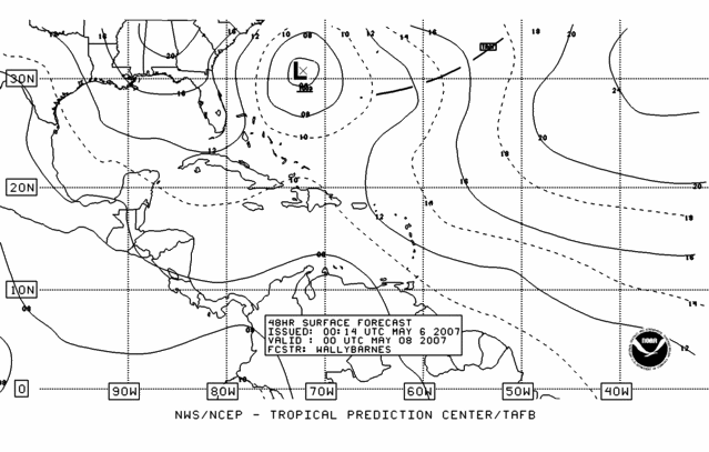
NHC 48 hrs:
Image

Low pressure, 1003 mb.
0 likes   

cpdaman
Category 5
Category 5
Posts: 3131
Joined: Sat Jun 10, 2006 11:44 am
Location: SPB county (gulf stream)

#116 Postby cpdaman » Sat May 05, 2007 8:46 pm

water temps off melborne are 79 degrees

also water temps above 77 run from a line about 31n 78 west NE thru 32N 74.5 west which is roughly offshore GA from 100 to 300 miles

then temps 72-76 immediately north and west of that line as well as running about 100 miles south of NC outer banks
0 likes   

JonathanBelles
Professional-Met
Professional-Met
Posts: 11430
Age: 34
Joined: Sat Dec 24, 2005 9:00 pm
Location: School: Florida State University (Tallahassee, FL) Home: St. Petersburg, Florida
Contact:

#117 Postby JonathanBelles » Sat May 05, 2007 9:23 pm

looks like every thing on the IR is moving SE.
0 likes   

User avatar
MGC
S2K Supporter
S2K Supporter
Posts: 5885
Joined: Sun Mar 23, 2003 9:05 pm
Location: Pass Christian MS, or what is left.

#118 Postby MGC » Sat May 05, 2007 11:01 pm

A couple of the models at 1800 5/5/07 (NAM, HRW) deepen this low under 990mb. With a ridge over the SE and the low parked over the GS it is possible that a transistion to some type of warm core or hybrid system is possible. Could possibly have a TS or STS next week if the models are right......MGC
0 likes   

cpdaman
Category 5
Category 5
Posts: 3131
Joined: Sat Jun 10, 2006 11:44 am
Location: SPB county (gulf stream)

#119 Postby cpdaman » Sat May 05, 2007 11:32 pm

key west NOAA discussion says a 7 pm quickskat pass showed low pressure developing about 200-250 miles east of south carolina and this low is supposed to move SE to near 31N 71W per sw n atlantic 1130 discussion and then drift westward and strengthen thru mon nite and maintain strength thru early tuesday reaching 31n 74 w then weaken thereaftore and turn "offshore"

to bad the bouy 250 miles east of charleston, sc is " reparied but turned off, and will be turned on when we can work it into the schedule" per NDBC heading sounds laughable 2 me
Last edited by cpdaman on Sat May 05, 2007 11:34 pm, edited 1 time in total.
0 likes   

User avatar
NDG
S2K Supporter
S2K Supporter
Posts: 15446
Joined: Sun Jul 09, 2006 10:14 pm
Location: Orlando, FL

#120 Postby NDG » Sat May 05, 2007 11:33 pm

New 00z GFS run makes it even more complicating, very inconsistant, it now forecasts to retrograde westward a lot faster moving it inland near Charleston S.C. Wednesday morning.
0 likes   


Return to “Talkin' Tropics”

Who is online

Users browsing this forum: Google [Bot], IsabelaWeather and 195 guests