2018 EPAC Season
Moderator: S2k Moderators
Forum rules
The posts in this forum are NOT official forecasts and should not be used as such. They are just the opinion of the poster and may or may not be backed by sound meteorological data. They are NOT endorsed by any professional institution or STORM2K. For official information, please refer to products from the National Hurricane Center and National Weather Service.
Re: 2018 EPAC Season
Still an agitated basin.
1 likes
The above post and any post by Ntxw is NOT an official forecast and should not be used as such. It is just the opinion of the poster and may or may not be backed by sound meteorological data. It is NOT endorsed by any professional institution including Storm2k. For official information, please refer to NWS products.
- Yellow Evan
- Professional-Met
- Posts: 15960
- Age: 25
- Joined: Fri Jul 15, 2011 12:48 pm
- Location: Henderson, Nevada/Honolulu, HI
- Contact:
Re: 2018 EPAC Season
426
ABPZ20 KNHC 240553
TWOEP
Tropical Weather Outlook
NWS National Hurricane Center Miami FL
1100 PM PDT Thu Aug 23 2018
For the eastern North Pacific...east of 140 degrees west longitude:
A trough of low pressure is producing disorganized showers and
thunderstorms several hundred miles south-southwest of the southern
tip of the Baja California Peninsula. Gradual development of this
system is possible through early next week while the disturbance
moves westward around 10 mph.
* Formation chance through 48 hours...low...near 0 percent.
* Formation chance through 5 days...medium...40 percent.
An area of low pressure could form in a few days well to the
east-southeast of the Hawaiian Islands. Some slow development of
this system is possible early next week while it moves westward or
west-northwestward at about 10 mph.
* Formation chance through 48 hours...low...near 0 percent.
* Formation chance through 5 days...low...30 percent.
$$
Forecaster Beven
0 likes
Re: 2018 EPAC Season
More organized this morning? Now 10/40
1 likes
The above post and any post by Ntxw is NOT an official forecast and should not be used as such. It is just the opinion of the poster and may or may not be backed by sound meteorological data. It is NOT endorsed by any professional institution including Storm2k. For official information, please refer to NWS products.
- Yellow Evan
- Professional-Met
- Posts: 15960
- Age: 25
- Joined: Fri Jul 15, 2011 12:48 pm
- Location: Henderson, Nevada/Honolulu, HI
- Contact:
Re: 2018 EPAC Season
635
ABPZ20 KNHC 241736
TWOEP
Tropical Weather Outlook
NWS National Hurricane Center Miami FL
1100 AM PDT Fri Aug 24 2018
For the eastern North Pacific...east of 140 degrees west longitude:
A broad area of low pressure located about 1000 miles west-southwest
of the southern tip of the Baja California peninsula continues to
produce disorganized shower activity. Gradual development of this
system is possible during the next several days while the
disturbance moves westward around 10 mph.
* Formation chance through 48 hours...low...10 percent.
* Formation chance through 5 days...medium...50 percent.
An area of low pressure could form within the next few days well to
the east-southeast of the Hawaiian Islands. Development, if any, of
this system should be slow to occur next week while it moves
westward or west-northwestward at about 10 mph.
* Formation chance through 48 hours...low...near 0 percent.
* Formation chance through 5 days...low...20 percent.
$$
Forecaster Cangialosi
0 likes
Re: 2018 EPAC Season
Lane will likely be in the history book of hurricane names; looks almost certain to be retired.
0 likes
blonde stacey (xe/xem/xir)
- cycloneye
- Admin
- Posts: 139593
- Age: 67
- Joined: Thu Oct 10, 2002 10:54 am
- Location: San Juan, Puerto Rico
Re: 2018 EPAC Season
Tropical Weather Outlook
NWS National Hurricane Center Miami FL
500 PM PDT Fri Aug 24 2018
For the eastern North Pacific...east of 140 degrees west longitude:
1. An elongated area of low pressure located about 1000 miles
south-southwest of the southern tip of the Baja California peninsula
continues to produce disorganized showers and a few thunderstorms.
Gradual development of this system is possible during the next
several days, and a tropical depression could form by the middle of
next week while the system moves westward around 10 mph.
* Formation chance through 48 hours...low...10 percent.
* Formation chance through 5 days...medium...50 percent.
2. An area of low pressure could form well to the east-southeast of the
Hawaiian Islands in a couple of days. Development of this system, if
any, should be slow to occur next week while it moves westward or
west-northwestward at about 10 mph.
* Formation chance through 48 hours...low...near 0 percent.
* Formation chance through 5 days...low...10 percent.
Forecaster Zelinsky
0 likes
Visit the Caribbean-Central America Weather Thread where you can find at first post web cams,radars
and observations from Caribbean basin members Click Here
Re: 2018 EPAC Season
18z GFS finally turns the 10/50 into a potent system after being so so for days. Develops more behind it, another outburst is in the works. NHC may need to bring out the colors again. As has been the past month, anything that wants to spin up seemingly has been doing so.
2 likes
The above post and any post by Ntxw is NOT an official forecast and should not be used as such. It is just the opinion of the poster and may or may not be backed by sound meteorological data. It is NOT endorsed by any professional institution including Storm2k. For official information, please refer to NWS products.
- Kingarabian
- S2K Supporter
- Posts: 15461
- Joined: Sat Aug 08, 2009 3:06 am
- Location: Honolulu, Hawaii
Re: 2018 EPAC Season
The EPAC squad on Storm2k has grown with Hector and Lane, and I think we set a record for an EPAC/CPAC storm with 100+ pages.
Looks like we're in for a busy September with more long trackers.
4 likes
RIP Kobe Bryant
- Kingarabian
- S2K Supporter
- Posts: 15461
- Joined: Sat Aug 08, 2009 3:06 am
- Location: Honolulu, Hawaii
Re: 2018 EPAC Season
FV3-GFS has an odd track for Miriam in the long range:
Euro like 0/10 system more, GFS likes the 0/50.
0 likes
RIP Kobe Bryant
- cycloneye
- Admin
- Posts: 139593
- Age: 67
- Joined: Thu Oct 10, 2002 10:54 am
- Location: San Juan, Puerto Rico
Re: 2018 EPAC Season
Tropical Weather Outlook
NWS National Hurricane Center Miami FL
1100 PM PDT Fri Aug 24 2018
For the eastern North Pacific...east of 140 degrees west longitude:
1. An elongated area of low pressure located about 1000 miles
south-southwest of the southern tip of the Baja California peninsula
continues to produce disorganized showers and a few thunderstorms.
Gradual development of this system is possible during the next
several days, and a tropical depression could form by the middle of
next week while the system moves westward around 10 mph.
* Formation chance through 48 hours...low...10 percent.
* Formation chance through 5 days...medium...50 percent.
2. An area of low pressure could form well to the east-southeast of the
Hawaiian Islands in a couple of days. However, development of this
system, if any, should be slow to occur next week while it moves
westward or west-northwestward at about 10 mph.
* Formation chance through 48 hours...low...near 0 percent.
* Formation chance through 5 days...low...near 0 percent.
3. A broad area of low pressure has developed several hundred miles
south-south of Acapulco, Mexico. Some gradual development of this
system is possible over the next several days while it moves
westward or west-northwestward at about 10 mph.
* Formation chance through 48 hours...low...near 0 percent.
* Formation chance through 5 days...low...20 percent.
Forecaster Stewart
0 likes
Visit the Caribbean-Central America Weather Thread where you can find at first post web cams,radars
and observations from Caribbean basin members Click Here
- cycloneye
- Admin
- Posts: 139593
- Age: 67
- Joined: Thu Oct 10, 2002 10:54 am
- Location: San Juan, Puerto Rico
Re: 2018 EPAC Season
Tropical Weather Outlook
NWS National Hurricane Center Miami FL
500 AM PDT Sat Aug 25 2018
For the eastern North Pacific...east of 140 degrees west longitude:
Shower activity has changed little since yesterday in association
with a broad area of low pressure located about 1000 miles southwest
of the southern tip of the Baja California peninsula. Gradual
development of this system is possible during the next several days,
and a tropical depression could form by the middle of next week
while the system moves westward around 10 mph.
* Formation chance through 48 hours...low...10 percent.
* Formation chance through 5 days...medium...50 percent.
Another broad area of low pressure is located several hundred miles
south of Acapulco, Mexico. Some slow development of this
system is possible over the next several days while it moves
westward or west-northwestward at 10 mph.
* Formation chance through 48 hours...low...near 0 percent.
* Formation chance through 5 days...low...20 percent.
Forecaster Cangialosi
0 likes
Visit the Caribbean-Central America Weather Thread where you can find at first post web cams,radars
and observations from Caribbean basin members Click Here
- xtyphooncyclonex
- Category 5
- Posts: 3688
- Age: 22
- Joined: Sat Dec 08, 2012 9:07 am
- Location: Cebu City
- Contact:
Re: 2018 EPAC Season
The current season is the season of intense long-tracking hurricanes. Best season I've tracked so far, surpassing 2015. Correct me if I'm wrong, but 2018 is the first season in the 21st century to have at least two hurricanes with ACE above 40 each. Miriam (and other storms) could follow Hector and Lane. I also expect and hope for a system similar to Ioke crossing the West Pacific and racking up heaps of ACE, except for the Johnston Atoll impact. High ACE long trackers that avoid land are my favorite.
2018 is on its way to becoming a hyperactive season. Perhaps it could be the first >200 season since 2015, and the second in the century. The streak would have continued if it weren't for 2017.
2 likes
REMINDER: My opinions that I, or any other NON Pro-Met in this forum, are unofficial. Please do not take my opinions as an official forecast and warning. I am NOT a meteorologist. Following my forecasts blindly may lead to false alarm, danger and risk if official forecasts from agencies are ignored.
Re: 2018 EPAC Season
xtyphooncyclonex wrote:2018 is on its way to becoming a hyperactive season. Perhaps it could be the first >200 season since 2015, and the second in the century. The streak would have continued if it weren't for 2017.
Getting to 200 isn't difficult given where things are. A long tracker, and a few typical eastern basin systems Sept/Oct/Nov can easily do it. So if we just follow climo it's there. Now to get within striking distance of 1992/2015 we'll need two long trackers similar to that of Lane/Hector and a bunch of shorter ACE systems. Or we can pull it off like 2015 and a whole bunch of Cat 4s in the eastern basin the rest of the way.
4 likes
The above post and any post by Ntxw is NOT an official forecast and should not be used as such. It is just the opinion of the poster and may or may not be backed by sound meteorological data. It is NOT endorsed by any professional institution including Storm2k. For official information, please refer to NWS products.
- Yellow Evan
- Professional-Met
- Posts: 15960
- Age: 25
- Joined: Fri Jul 15, 2011 12:48 pm
- Location: Henderson, Nevada/Honolulu, HI
- Contact:
Re: 2018 EPAC Season
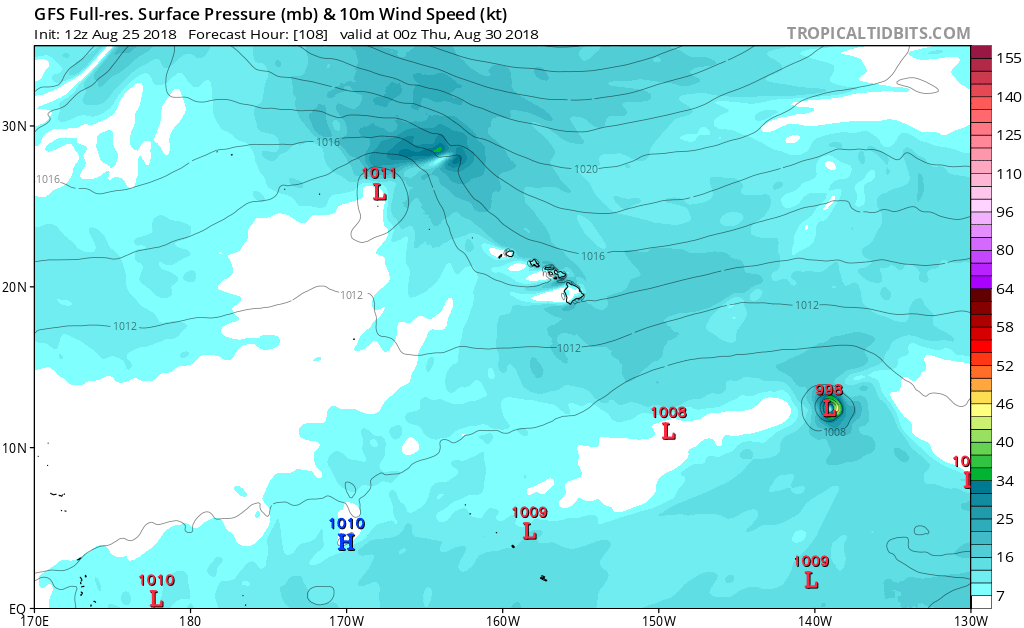
Kingarabian wrote:FV3-GFS has an odd track for Miriam in the long range:
https://i.imgur.com/sAQkPrd.gif
Euro like 0/10 system more, GFS likes the 0/50.
ECMWF is high on the 10/50 while the GFS is showing the 0/20.
1 likes
Re: 2018 EPAC Season
Something to note. I know Yellow Evan touched based with this but the longer range guidance has had northerly bias with west tracking systems. Miriam to be, like Lane and Hector, what looked like a safe east recurve is now progged further south on the guidance. Sitting near the same spots the predecessors were. Sprawling 500mb north Pacific ridge.
Hawaii could be staring at another system nearby
1 likes
The above post and any post by Ntxw is NOT an official forecast and should not be used as such. It is just the opinion of the poster and may or may not be backed by sound meteorological data. It is NOT endorsed by any professional institution including Storm2k. For official information, please refer to NWS products.
- cycloneye
- Admin
- Posts: 139593
- Age: 67
- Joined: Thu Oct 10, 2002 10:54 am
- Location: San Juan, Puerto Rico
Re: 2018 EPAC Season
12z GFS is loaded with 5 systems developing. (Longtrackers and less longtrackers)
1 likes
Visit the Caribbean-Central America Weather Thread where you can find at first post web cams,radars
and observations from Caribbean basin members Click Here
- cycloneye
- Admin
- Posts: 139593
- Age: 67
- Joined: Thu Oct 10, 2002 10:54 am
- Location: San Juan, Puerto Rico
Re: 2018 EPAC Season
Tropical Weather Outlook
NWS National Hurricane Center Miami FL
1100 AM PDT Sat Aug 25 2018
For the eastern North Pacific...east of 140 degrees west longitude:
An area of low pressure located about 1000 miles southwest of the
southern tip of the Baja California peninsula continues to produce
disorganized showers and thunderstorms. Environmental conditions
appear conducive for gradual development, and a tropical depression
could form within the next few days while the system moves
westward around 10 mph.
* Formation chance through 48 hours...low...20 percent.
* Formation chance through 5 days...medium...60 percent.
A broad low pressure system located about 500 miles south
of Acapulco, Mexico, is producing a large area of disorganized
showers and thunderstorms. Slow development of this system is
expected, and a tropical depression could form by the middle of
next week while it moves westward or west-northwestward at 10 mph.
* Formation chance through 48 hours...low...10 percent.
* Formation chance through 5 days...medium...40 percent.
$$
Forecaster Cangialosi
0 likes
Visit the Caribbean-Central America Weather Thread where you can find at first post web cams,radars
and observations from Caribbean basin members Click Here
- cycloneye
- Admin
- Posts: 139593
- Age: 67
- Joined: Thu Oct 10, 2002 10:54 am
- Location: San Juan, Puerto Rico
Re: 2018 EPAC Season
The 10/40 system near 100W should be Invest 90E very soon looking at how it is trending on convection having a spin.
1 likes
Visit the Caribbean-Central America Weather Thread where you can find at first post web cams,radars
and observations from Caribbean basin members Click Here
- 1900hurricane
- Category 5
- Posts: 6044
- Age: 33
- Joined: Fri Feb 06, 2015 12:04 pm
- Location: Houston, TX
- Contact:
Re: 2018 EPAC Season
Monsoon troughing for the win!
4 likes
Contract Meteorologist. TAMU & MSST. Fiercely authentic, one of a kind. We are all given free will, so choose a life meant to be lived. We are the Masters of our own Stories.
Opinions expressed are mine alone.
Follow me on Twitter at @1900hurricane : Read blogs at https://1900hurricane.wordpress.com/
Opinions expressed are mine alone.
Follow me on Twitter at @1900hurricane : Read blogs at https://1900hurricane.wordpress.com/
Who is online
Users browsing this forum: Cpv17, duilaslol, IsabelaWeather, Killjoy12, MEANINGLESS_NUMBERS, skyline385, South Texas Storms, StormWeather, wwizard and 96 guests