Yes Orlando, West Palm Beach, Fort Lauderdale, and Miami metropolitan areas really lucked out over the past four seasons when it came to Matthew, Irma, and Dorian. Though Miami got some decent storm surge from Irma. One of these days our luck will run out!
2020 Indicators: SST's / SAL / MSLP / Steering / Shear / Instability / Sat Images
Moderator: S2k Moderators
Forum rules

The posts in this forum are NOT official forecasts and should not be used as such. They are just the opinion of the poster and may or may not be backed by sound meteorological data. They are NOT endorsed by any professional institution or STORM2K. For official information, please refer to products from the National Hurricane Center and National Weather Service.
-
TheStormExpert
Re: 2020 Indicators: SST's / SAL / MSLP / Steering / Shear / Instability / Sat Images
Yes Orlando, West Palm Beach, Fort Lauderdale, and Miami metropolitan areas really lucked out over the past four seasons when it came to Matthew, Irma, and Dorian. Though Miami got some decent storm surge from Irma. One of these days our luck will run out!
7 likes
Re: 2020 Indicators: SST's / SAL / MSLP / Steering / Shear / Instability / Sat Images
The last major to pass over my neighborhood...was 99 years ago. TCs are sufficiently rare that they operate on a timescale beyond a human lifetime leading to either a false sense of security or an unreasonable fear depending on recent history in a given locale. that's one of their secret weapons. they fool us with long term randomness. Enjoy the tranquility while it is here. there's probably going to be more than one life changing impact somewhere in the basin this year.
2 likes
-
Socalhurcnegirl227
- Category 1

- Posts: 267
- Age: 37
- Joined: Mon Jun 06, 2016 6:39 pm
- Location: Santa Barbara, CA
Re: 2020 Indicators: SST's / SAL / MSLP / Steering / Shear / Instability / Sat Images
TheStormExpert wrote:
Yes Orlando, West Palm Beach, Fort Lauderdale, and Miami metropolitan areas really lucked out over the past four seasons when it came to Matthew, Irma, and Dorian. Though Miami got some decent storm surge from Irma. One of these days our luck will run out!
The one city im afraid for when their luck runs out in terms of a major hit is New Orleans. No major since Katrina I believe.
1 likes
"I'm a wandress, i'm a one night stand,
dont belong to no city, dont belong to no man
i'm the violence in the pouring rain,
I'm a hurricane"
dont belong to no city, dont belong to no man
i'm the violence in the pouring rain,
I'm a hurricane"
-
CYCLONE MIKE
- Category 5

- Posts: 2183
- Joined: Tue Aug 31, 2004 6:04 pm
- Location: Gonzales, LA
Re: 2020 Indicators: SST's / SAL / MSLP / Steering / Shear / Instability / Sat Images
Socalhurcnegirl227 wrote:TheStormExpert wrote:
Yes Orlando, West Palm Beach, Fort Lauderdale, and Miami metropolitan areas really lucked out over the past four seasons when it came to Matthew, Irma, and Dorian. Though Miami got some decent storm surge from Irma. One of these days our luck will run out!
The one city im afraid for when their luck runs out in terms of a major hit is New Orleans. No major since Katrina I believe.
Katrina was barely a cat 3 and brushed New Orleans. If it wasn’t for the levees failing it would have been a minimal hit and never would have made the story it did. It was Mississippi that caught the full force of her and didn’t get the news coverage that it should have.
But yes you would think New Orleans’ luck would eventually run out as almost every storm that threatens the area either veers off to the east or weakens substantially off the coast before landfall. But that being said we can do this all day and say almost every big city along the coast is way overdue.
10 likes
-
Dougiefresh
- Tropical Depression

- Posts: 55
- Age: 36
- Joined: Thu Jun 08, 2017 8:07 am
- Location: Barbados
Re: 2020 Indicators: SST's / SAL / MSLP / Steering / Shear / Instability / Sat Images

This is the worst Sahara dust outbreak I have seen in Barbados. Visibility is almost down to the level of fog.
8 likes

Re: 2020 Indicators: SST's / SAL / MSLP / Steering / Shear / Instability / Sat Images
One final post on July storms: I went back to all the seasons from 1980-2019 and recorded every single named July system, and divided them into two categories. There are those formed from AEWs (they don’t have to be within the MDR/Caribbean), and those formed in other ways (decaying fronts, random areas of low pressure, etc). More than half of the seasons in the 1980-2019 time frame had at least one July system, and many of those had storms from both categories, either a storm from an AEW and another from a different method, or one storm formed from a combination of those methods. Bolded years only have AEW-based July systems, italic years only have systems from other types of precursor disturbances, and years with an “*” have both.
1985*, 1989*, 1990*, 1991, 1995*, 1996, 1997, 1998, 2002, 2003, 2004*, 2005, 2006, 2007, 2008*, 2010, 2011*, 2013, 2014, 2015, 2017, 2018*, 2019.
Afterwards, I took the mean seasonal parameters for both categories. The “double-dipper” seasons were included in both averages. The average for AEW seasons did change because I expanded my definition.
AEW SEASONS
—1985, 1989, 1990, 1995, 1996, 1998, 2003, 2004, 2005, 2008, 2010, 2011, 2013, 2017, 2018
—16.1 named storms
—8.7 hurricanes
—3.9 major hurricanes
—158.66 ACE
OTHER FORMATION SEASONS
—1985, 1989, 1990, 1991, 1995, 1997, 2002, 2004, 2006, 2007, 2008, 2011, 2014, 2015, 2018, 2019
—13.1 named storms
—6.4 hurricanes
—2.8 major hurricanes
—108.56 ACE
As suspected a little earlier in this thread, July MDR/Caribbean systems formed from AEWs do indeed signal a more active season than July systems formed from other methods. I’m quite surprised at the significant differences between the averages; the first is on the border of an above-average and hyperactive season, and the second is near the Atlantic average of 12/6/3 and 93 ACE. I think there’s now plenty of evidence to say that if we get at least one July system from a tropical wave in the MDR, 2020 will be an active season.
8 likes
Irene '11 Sandy '12 Hermine '16 5/15/2018 Derecho Fay '20 Isaias '20 Elsa '21 Henri '21 Ida '21
I am only a meteorology enthusiast who knows a decent amount about tropical cyclones. Look to the professional mets, the NHC, or your local weather office for the best information.
I am only a meteorology enthusiast who knows a decent amount about tropical cyclones. Look to the professional mets, the NHC, or your local weather office for the best information.
Re: 2020 Indicators: SST's / SAL / MSLP / Steering / Shear / Instability / Sat Images
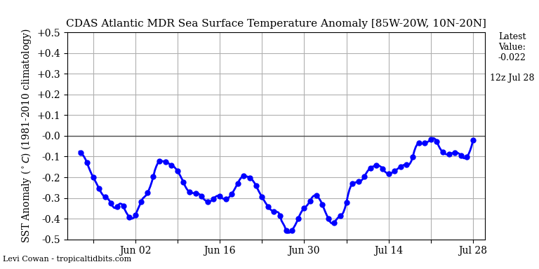
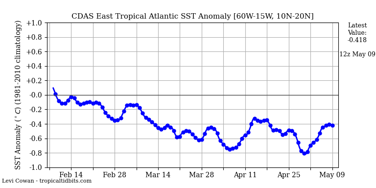
Despite the sal, atlantic STT in The MDR, and east tropical atlantic don't decrease
1 likes


-
BYG Jacob
Re: 2020 Indicators: SST's / SAL / MSLP / Steering / Shear / Instability / Sat Images
Looks like the setup for at least 1 MDR storm
0 likes

Re: 2020 Indicators: SST's / SAL / MSLP / Steering / Shear / Instability / Sat Images
SFLcane wrote:So we have come to agreement on cv storms recurving east of the islands this year? Folks let’s wait till mid July or early August for an idea how the Bermuda high will setup. I am concerned about impacts the season especially to the Caribbean and also Florida.
Oh hell no
 I personally am firmly in the "low-rider" and Caribbean camp and am particularly concerned that this year will bring an increased risk to Florida, W. Cuba, Central America, and Gulf Coast area's as well. I do think that a secondary split of tracks might re-curve east of the Lesser Antilles but unlike most from past years, I think strong N.W. Atlantic ridging will result in these tracks to bend back to the N.W. and eventually threaten the Northeast U.S. seaboard & Canadian maritime's. There may be a couple mid-Atlantic re-curves but I think that may simply be a result of latter season MDR development (late Sept/Oct) when Climo would typically suggest receding mid level heights across the Eastern/Central Atlantic at that time.
 It would be an interesting poll to see where others think that most tracks will occur but I can't think of any way to break down the possibilities especially given that there's generally at least a couple of seasonal track patterns each season (and sometimes a broad spread of "south to north" tracks across the basin).
5 likes
Andy D
(For official information, please refer to the NHC and NWS products.)
(For official information, please refer to the NHC and NWS products.)
-
Shell Mound
- Category 5
- Posts: 2432
- Age: 33
- Joined: Thu Sep 07, 2017 3:39 pm
- Location: St. Petersburg, FL → Scandinavia
Re: 2020 Indicators: SST's / SAL / MSLP / Steering / Shear / Instability / Sat Images
CyclonicFury, is the June NMME more or less favourable for the Atlantic vs. its May run?
0 likes
CVW / MiamiensisWx / Shell Mound
The posts in this forum are NOT official forecasts and should not be used as such. They are just the opinion of the poster and may or may not be backed by sound meteorological data. They are NOT endorsed by any professional institution or STORM2K. For official information, please refer to products from the NHC and NWS.
-
CyclonicFury

- Category 5
- Posts: 2033
- Age: 27
- Joined: Sun Jul 02, 2017 12:32 pm
- Location: NC
- Contact:
Re: 2020 Indicators: SST's / SAL / MSLP / Steering / Shear / Instability / Sat Images
Shell Mound wrote:CyclonicFury, is the June NMME more or less favourable for the Atlantic vs. its May run?
It's about the same, but NMME has not run in two weeks.
0 likes
NCSU B.S. in Meteorology Class of 2021. Tropical weather blogger at http://www.cyclonicfury.com. My forecasts and thoughts are NOT official, for official forecasts please consult the National Hurricane Center.

Re: 2020 Indicators: SST's / SAL / MSLP / Steering / Shear / Instability / Sat Images
Socalhurcnegirl227 wrote:TheStormExpert wrote:
Yes Orlando, West Palm Beach, Fort Lauderdale, and Miami metropolitan areas really lucked out over the past four seasons when it came to Matthew, Irma, and Dorian. Though Miami got some decent storm surge from Irma. One of these days our luck will run out!
The one city im afraid for when their luck runs out in terms of a major hit is New Orleans. No major since Katrina I believe.
That's right, and it was a mostly favorable track east of us. We've been hit or had impacts from several storms since, but they've all been minor for us in comparison (Rita, Gustav, Ike, Isaac, Olga, Crystobal). In yesterday's Saturday summary, Joe B showed that the closest water temperature profile is 2005. He said he's not calling for 2005 results, but obviously that warm / cold / warm configuration in the Atlantic Ocean is at least concerning now if it stays similar over the next 2-3 months.
3 likes
Re: 2020 Indicators: SST's / SAL / MSLP / Steering / Shear / Instability / Sat Images
One last post about July storms: it turns out I completely forgot about Emily ‘17, so 2017 is another double-dipper season. The revised mean seasonal parameters for years with non-AEW July systems are:
—13.4 named storms
—6.6 hurricanes
—2.9 major hurricanes
—115.40 ACE
So even with systems that don’t form from waves, there’s a decent chance of the season being at least slightly above-average if it has any kind of storm in July.
However, I was becoming curious about whether or not frequency of storms in July really has any impact on seasonal activity. Two seasons that led me to wonder this were 2004 and 2013. The former didn’t have its first storm until the last day in July, and the latter had two MDR tropical storms. 2004 was one of the most active on record while 2013 had less ACE than Hurricane Jose. After combing through all of those seasons once again, this is why I found.
SEASONAL AVERAGES FOR 1 JULY STORM
—1991, 1998, 2002, 2004, 2007, 2010, 2014, 2015, 2019
—13.3 named storms
—6.8 hurricanes
—3.0 major hurricanes
—112.57 ACE
SEASONAL AVERAGES FOR 2+ JULY STORMS
—1985, 1989, 1990, 1995, 1996, 1997, 2003, 2005, 2006, 2008, 2011, 2013, 2017, 2018
—15.1 named storms
—7.6 hurricanes
—3.4 major hurricanes
—137.52 ACE
So even with a couple of outliers like 2004 and 2013, more July storms does usually mean a more active season overall, but it’s not as much of a difference as the formation methods of these systems. Now we can see what kind of scenarios in July would favor more or less activity for the rest of the season. No systems or 1 July system formed from alternative methods would indicate a near-average season (80-120 ACE), while multiple MDR/AEW systems would suggest a hyperactive season (220-250 ACE). A mix of AEW and alternative formation July systems, or one MDR system, would indicate an active season in the 130-160 ACE range.
One key takeaway: if we get at least 2 July systems this year from AEWs, then it’s time to panic.
5 likes
Irene '11 Sandy '12 Hermine '16 5/15/2018 Derecho Fay '20 Isaias '20 Elsa '21 Henri '21 Ida '21
I am only a meteorology enthusiast who knows a decent amount about tropical cyclones. Look to the professional mets, the NHC, or your local weather office for the best information.
I am only a meteorology enthusiast who knows a decent amount about tropical cyclones. Look to the professional mets, the NHC, or your local weather office for the best information.
-
SFLcane

- S2K Supporter

- Posts: 10281
- Age: 48
- Joined: Sat Jun 05, 2010 1:44 pm
- Location: Lake Worth Florida
Re: 2020 Indicators: SST's / SAL / MSLP / Steering / Shear / Instability / Sat Images
Hi StruThi0, Not sure what we are looking at here it's not showing TCs.
0 likes
-
Socalhurcnegirl227
- Category 1
- Posts: 267
- Age: 37
- Joined: Mon Jun 06, 2016 6:39 pm
- Location: Santa Barbara, CA
Re: 2020 Indicators: SST's / SAL / MSLP / Steering / Shear / Instability / Sat Images
Steve wrote:Socalhurcnegirl227 wrote:TheStormExpert wrote:Yes Orlando, West Palm Beach, Fort Lauderdale, and Miami metropolitan areas really lucked out over the past four seasons when it came to Matthew, Irma, and Dorian. Though Miami got some decent storm surge from Irma. One of these days our luck will run out!
The one city im afraid for when their luck runs out in terms of a major hit is New Orleans. No major since Katrina I believe.
That's right, and it was a mostly favorable track east of us. We've been hit or had impacts from several storms since, but they've all been minor for us in comparison (Rita, Gustav, Ike, Isaac, Olga, Crystobal). In yesterday's Saturday summary, Joe B showed that the closest water temperature profile is 2005. He said he's not calling for 2005 results, but obviously that warm / cold / warm configuration in the Atlantic Ocean is at least concerning now if it stays similar over the next 2-3 months.
Thats exactly where my concern grows for the gulf region especially following Joe Bs constant comparison for 2005 in terms of the conditions developing.
On a side note with that being said, i hope Brees reconsiders retirement and plays one last season in 2021, with all the varying issues and potential issues that could plague the fall of 2020
1 likes
"I'm a wandress, i'm a one night stand,
dont belong to no city, dont belong to no man
i'm the violence in the pouring rain,
I'm a hurricane"
dont belong to no city, dont belong to no man
i'm the violence in the pouring rain,
I'm a hurricane"
-
cycloneye

- Admin

- Posts: 149431
- Age: 69
- Joined: Thu Oct 10, 2002 10:54 am
- Location: San Juan, Puerto Rico
Re: 2020 Indicators: SST's / SAL / MSLP / Steering / Shear / Instability / Sat Images
I guess some will not like this Webb thread.
https://twitter.com/webberweather/status/1274804010596405258
https://twitter.com/webberweather/status/1274807563150917633
https://twitter.com/webberweather/status/1274804010596405258
https://twitter.com/webberweather/status/1274807563150917633
1 likes
Visit the Caribbean-Central America Weather Thread where you can find at first post web cams,radars
and observations from Caribbean basin members Click Here
and observations from Caribbean basin members Click Here
Re: 2020 Indicators: SST's / SAL / MSLP / Steering / Shear / Instability / Sat Images
3 likes
Irene '11 Sandy '12 Hermine '16 5/15/2018 Derecho Fay '20 Isaias '20 Elsa '21 Henri '21 Ida '21
I am only a meteorology enthusiast who knows a decent amount about tropical cyclones. Look to the professional mets, the NHC, or your local weather office for the best information.
I am only a meteorology enthusiast who knows a decent amount about tropical cyclones. Look to the professional mets, the NHC, or your local weather office for the best information.
Who is online
Users browsing this forum: Cdenton12 and 44 guests