2022 Indicators (SSTs/SAL/MSLP/Shear/Steering/Instability) and >Day 16 Models

This is the general tropical discussion area. Anyone can take their shot at predicting a storms path.

Moderator: S2k Moderators

Forum rules

The posts in this forum are NOT official forecasts and should not be used as such. They are just the opinion of the poster and may or may not be backed by sound meteorological data. They are NOT endorsed by any professional institution or STORM2K. For official information, please refer to products from the National Hurricane Center and National Weather Service.

Help Support Storm2K
Message
Author
Nuno
Category 2
Category 2
Posts: 533
Joined: Fri Aug 30, 2019 8:35 am
Location: Coral Gables, FL

Re: 2022 Indicators (SSTs/SAL/MSLP/Shear/Steering/Instability) and >Day 16 Models

#1001 Postby Nuno » Sun Jun 05, 2022 5:16 pm

toad strangler wrote:So much SST handwringing across the campus :D

The AEW's will be there and they will move W. If SST's are off a smidge for the most part they will move a bit further W. And so on.


I am with you, Toad. On cue, every season here it is. SSTs will not be a problem in the MDR.
3 likes   
Andrew (1992), Irene (1999), Frances (2004), Katrina (2005), Wilma (2005), Fay (2008), Irma (2017), Eta (2020), Ian (2022)

User avatar
SFLcane
S2K Supporter
S2K Supporter
Posts: 9627
Age: 46
Joined: Sat Jun 05, 2010 1:44 pm
Location: Lake Worth Florida

Re: 2022 Indicators (SSTs/SAL/MSLP/Shear/Steering/Instability) and >Day 16 Models

#1002 Postby SFLcane » Sun Jun 05, 2022 7:51 pm

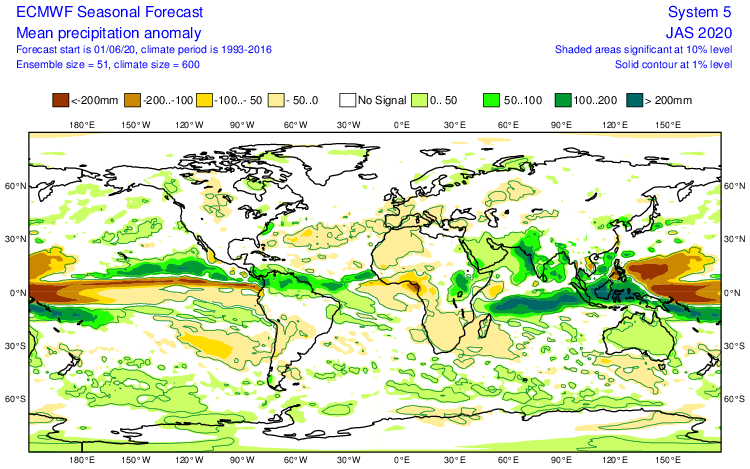
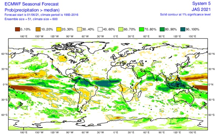
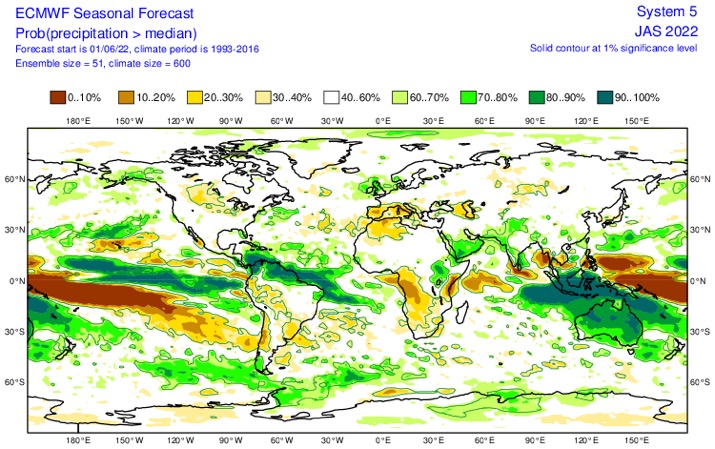
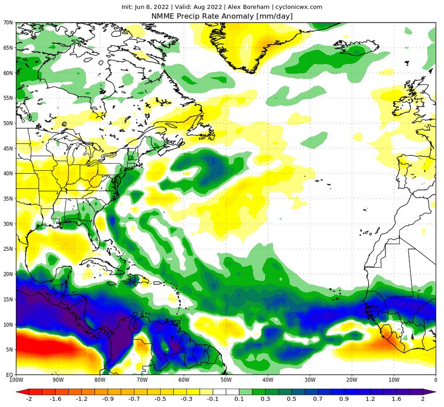
I seriously think that Florida’s shield unfortunately will finally give way this season. Be ready!

June 2020: dry SW Atlantic

Image

June 2021: Dry SW Atlantic

Image

June 2022 is very different

Image
9 likes   

User avatar
Category5Kaiju
Category 5
Category 5
Posts: 3447
Age: 22
Joined: Thu Dec 24, 2020 12:45 pm
Location: Seattle

Re: 2022 Indicators (SSTs/SAL/MSLP/Shear/Steering/Instability) and >Day 16 Models

#1003 Postby Category5Kaiju » Sun Jun 05, 2022 8:00 pm

SFLcane wrote:I seriously think that Florida’s shield unfortunately will finally give way this season. Be ready!

June 2020: dry SW Atlantic

https://i.postimg.cc/sXFvLP5p/D44-CFD7-F-A549-4-FFD-B7-EC-EA499-DF17-CBE.png

June 2021: Dry SW Atlantic

https://i.postimg.cc/Wb0SYSr7/BA6595-E3-9121-4-DE5-9-E3-B-B84-F80-F77-E4-E.jpg

June 2022 is very different

https://i.postimg.cc/wjH2CJQY/707446-AF-49-B9-4882-AEAB-D37742-F49250.jpg


Based on those maps, I think one nightmare (but plausible) storm track I could see panning out at some point this year is a very powerful Cat 4/5 Caribbean cruiser that turns north before hitting CA, passes through the Yucatan channel, and hits SW or W Florida.
3 likes   
Unless explicitly stated, all information covered in my posts is based on my opinions and observations. Please refer to a professional meteorologist or an accredited weather research agency otherwise, especially if serious decisions must be made in the event of a potentially life-threatening tropical storm or hurricane.

User avatar
LemieT
Tropical Depression
Tropical Depression
Posts: 75
Age: 38
Joined: Sun Jun 13, 2021 5:31 pm
Location: Barbados

Re: 2022 Indicators (SSTs/SAL/MSLP/Shear/Steering/Instability) and >Day 16 Models

#1004 Postby LemieT » Mon Jun 06, 2022 4:46 pm

Category5Kaiju wrote:
SFLcane wrote:I seriously think that Florida’s shield unfortunately will finally give way this season. Be ready!

June 2020: dry SW Atlantic

https://i.postimg.cc/sXFvLP5p/D44-CFD7-F-A549-4-FFD-B7-EC-EA499-DF17-CBE.png

June 2021: Dry SW Atlantic

https://i.postimg.cc/Wb0SYSr7/BA6595-E3-9121-4-DE5-9-E3-B-B84-F80-F77-E4-E.jpg

June 2022 is very different

https://i.postimg.cc/wjH2CJQY/707446-AF-49-B9-4882-AEAB-D37742-F49250.jpg


Based on those maps, I think one nightmare (but plausible) storm track I could see panning out at some point this year is a very powerful Cat 4/5 Caribbean cruiser that turns north before hitting CA, passes through the Yucatan channel, and hits SW or W Florida.


Ivan 2.0 - A distinct possibility.
1 likes   

zzh
Category 1
Category 1
Posts: 375
Joined: Fri Aug 27, 2021 2:18 pm

Re: 2022 Indicators (SSTs/SAL/MSLP/Shear/Steering/Instability) and >Day 16 Models

#1005 Postby zzh » Mon Jun 06, 2022 6:35 pm

Image
Long range EPS shows westerlies across the entire MDR.
5 likes   

User avatar
skyline385
Category 5
Category 5
Posts: 2615
Age: 33
Joined: Wed Aug 26, 2020 11:15 pm
Location: Houston TX

2022 Indicators (SSTs/SAL/MSLP/Shear/Steering/Instability) and >Day 16 Models

#1006 Postby skyline385 » Mon Jun 06, 2022 7:10 pm

zzh wrote:https://i.imgur.com/wWXrhjU.png
Long range EPS shows westerlies across the entire MDR.


There is still a significant amount of cooling going on in the eastern MDR regardless, what's interesting to me are the continuous westerlies across Nino 3.4.

Image
Last edited by skyline385 on Mon Jun 06, 2022 7:10 pm, edited 2 times in total.
0 likes   

User avatar
Kingarabian
S2K Supporter
S2K Supporter
Posts: 15462
Joined: Sat Aug 08, 2009 3:06 am
Location: Honolulu, Hawaii

Re: 2022 Indicators (SSTs/SAL/MSLP/Shear/Steering/Instability) and >Day 16 Models

#1007 Postby Kingarabian » Mon Jun 06, 2022 7:17 pm

zzh wrote:https://i.imgur.com/wWXrhjU.png
Long range EPS shows westerlies across the entire MDR.

Yeah pretty much the same as the CFS. Almost 3 weeks of uninterrupted slow trades.
1 likes   
RIP Kobe Bryant

User avatar
weeniepatrol
Category 3
Category 3
Posts: 871
Joined: Sat Aug 22, 2020 5:30 pm
Location: WA State

Re: 2022 Indicators (SSTs/SAL/MSLP/Shear/Steering/Instability) and >Day 16 Models

#1008 Postby weeniepatrol » Mon Jun 06, 2022 9:21 pm

Quite robust for 6 June...

4 likes   

User avatar
skyline385
Category 5
Category 5
Posts: 2615
Age: 33
Joined: Wed Aug 26, 2020 11:15 pm
Location: Houston TX

Re: 2022 Indicators (SSTs/SAL/MSLP/Shear/Steering/Instability) and >Day 16 Models

#1009 Postby skyline385 » Tue Jun 07, 2022 3:10 am

0 likes   

User avatar
Kingarabian
S2K Supporter
S2K Supporter
Posts: 15462
Joined: Sat Aug 08, 2009 3:06 am
Location: Honolulu, Hawaii

Re: 2022 Indicators (SSTs/SAL/MSLP/Shear/Steering/Instability) and >Day 16 Models

#1010 Postby Kingarabian » Tue Jun 07, 2022 4:17 am

skyline385 wrote:
zzh wrote:https://i.imgur.com/wWXrhjU.png
Long range EPS shows westerlies across the entire MDR.


There is still a significant amount of cooling going on in the eastern MDR regardless, what's interesting to me are the continuous westerlies across Nino 3.4.

https://uploads.tapatalk-cdn.com/20220607/f0caae8e4a3b96a02a5812d628307d44.jpg


Those are trades around Nino 3.4.
0 likes   
RIP Kobe Bryant

User avatar
NotSparta
Professional-Met
Professional-Met
Posts: 1660
Age: 22
Joined: Fri Aug 18, 2017 8:24 am
Location: Naples, FL
Contact:

Re: 2022 Indicators (SSTs/SAL/MSLP/Shear/Steering/Instability) and >Day 16 Models

#1011 Postby NotSparta » Tue Jun 07, 2022 7:08 am

weeniepatrol wrote:Quite robust for 6 June...

https://imgur.com/39XzU2Z


Yeah, convective activity has been quite impressive with several waves in that area the past week or so. Guessing they're getting a leg up thanks to MJO/CCKW
0 likes   
This post was probably an opinion of mine, and in no way is official. Please refer to http://www.hurricanes.gov for official tropical analysis and advisories.

My website, with lots of tropical wx graphics, including satellite and recon: http://cyclonicwx.com

User avatar
skyline385
Category 5
Category 5
Posts: 2615
Age: 33
Joined: Wed Aug 26, 2020 11:15 pm
Location: Houston TX

Re: 2022 Indicators (SSTs/SAL/MSLP/Shear/Steering/Instability) and >Day 16 Models

#1012 Postby skyline385 » Tue Jun 07, 2022 8:27 am

Kingarabian wrote:
skyline385 wrote:
zzh wrote:https://i.imgur.com/wWXrhjU.png
Long range EPS shows westerlies across the entire MDR.


There is still a significant amount of cooling going on in the eastern MDR regardless, what's interesting to me are the continuous westerlies across Nino 3.4.

https://uploads.tapatalk-cdn.com/20220607/f0caae8e4a3b96a02a5812d628307d44.jpg


Those are trades around Nino 3.4.

Yea but there is potential for the warmth to spread into it

https://twitter.com/andyhazelton/status ... 9804769282
0 likes   

User avatar
SFLcane
S2K Supporter
S2K Supporter
Posts: 9627
Age: 46
Joined: Sat Jun 05, 2010 1:44 pm
Location: Lake Worth Florida

Re: 2022 Indicators (SSTs/SAL/MSLP/Shear/Steering/Instability) and >Day 16 Models

#1013 Postby SFLcane » Tue Jun 07, 2022 8:32 am

0 likes   

User avatar
SFLcane
S2K Supporter
S2K Supporter
Posts: 9627
Age: 46
Joined: Sat Jun 05, 2010 1:44 pm
Location: Lake Worth Florida

Re: 2022 Indicators (SSTs/SAL/MSLP/Shear/Steering/Instability) and >Day 16 Models

#1014 Postby SFLcane » Tue Jun 07, 2022 8:40 am

......Watch......

Historic Hurricane Season Possible? New ECMWF Data Suggests So - June 6, 2022 (Hurricanetrack.com)

https://www.youtube.com/watch?v=ncL0WPTRVeU
5 likes   

User avatar
cycloneye
Admin
Admin
Posts: 139756
Age: 67
Joined: Thu Oct 10, 2002 10:54 am
Location: San Juan, Puerto Rico

Re: 2022 Indicators (SSTs/SAL/MSLP/Shear/Steering/Instability) and >Day 16 Models

#1015 Postby cycloneye » Tue Jun 07, 2022 9:18 am

3 likes   
Visit the Caribbean-Central America Weather Thread where you can find at first post web cams,radars
and observations from Caribbean basin members Click Here

User avatar
skyline385
Category 5
Category 5
Posts: 2615
Age: 33
Joined: Wed Aug 26, 2020 11:15 pm
Location: Houston TX

Re: 2022 Indicators (SSTs/SAL/MSLP/Shear/Steering/Instability) and >Day 16 Models

#1016 Postby skyline385 » Tue Jun 07, 2022 9:21 am


But subtropics continued to warm up during May?

Image
0 likes   

User avatar
SFLcane
S2K Supporter
S2K Supporter
Posts: 9627
Age: 46
Joined: Sat Jun 05, 2010 1:44 pm
Location: Lake Worth Florida

Re: 2022 Indicators (SSTs/SAL/MSLP/Shear/Steering/Instability) and >Day 16 Models

#1017 Postby SFLcane » Tue Jun 07, 2022 9:22 am

Watchout eastcoast... :crazyeyes:

Image
0 likes   

User avatar
SFLcane
S2K Supporter
S2K Supporter
Posts: 9627
Age: 46
Joined: Sat Jun 05, 2010 1:44 pm
Location: Lake Worth Florida

Re: 2022 Indicators (SSTs/SAL/MSLP/Shear/Steering/Instability) and >Day 16 Models

#1018 Postby SFLcane » Tue Jun 07, 2022 9:24 am

Certainly not the look of a TUTT protecting Florida this season. :eek:
0 likes   

User avatar
skyline385
Category 5
Category 5
Posts: 2615
Age: 33
Joined: Wed Aug 26, 2020 11:15 pm
Location: Houston TX

Re: 2022 Indicators (SSTs/SAL/MSLP/Shear/Steering/Instability) and >Day 16 Models

#1019 Postby skyline385 » Tue Jun 07, 2022 9:24 am

Even on his own site, subtropics have warmed up during May

Image
0 likes   

User avatar
Stormybajan
Category 1
Category 1
Posts: 428
Joined: Thu May 20, 2021 3:21 pm
Location: Windward Islands

Re: 2022 Indicators (SSTs/SAL/MSLP/Shear/Steering/Instability) and >Day 16 Models

#1020 Postby Stormybajan » Tue Jun 07, 2022 9:34 am


Definitely a concerning trend with the CSU,ECMWF hyperactive forecasts AND the track into the lesser antilies..BUT I am still not ready to hop onto the hyperactive train yet, the MDR will continue to cool for the next 2 weeks before we see some sustained warming until the end of June- Early July. I believe July will tell us a lot,2005,2017,2020 ALL had active MDRs during the month of July coupled with strong AEWS. If the MDR warms more than usual then look out but right now I think "just" above average is the best bet. Hyperactivity in the Atlantic is a rarity for a reason 8-)
3 likes   
Sad West Indies and Manchester United fan ⚽️


Return to “Talkin' Tropics”

Who is online

Users browsing this forum: No registered users and 33 guests