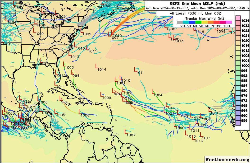
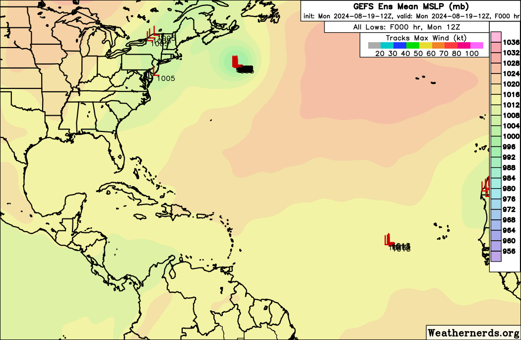
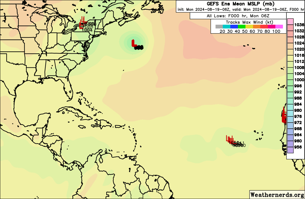
06z GEFS... A bit more active... Everything getting pulled N quickly, +NAO??
Moderator: S2k Moderators


mantis83 wrote:
looks like recurve city on those maps....

ConvergenceZone wrote:mantis83 wrote:
looks like recurve city on those maps....
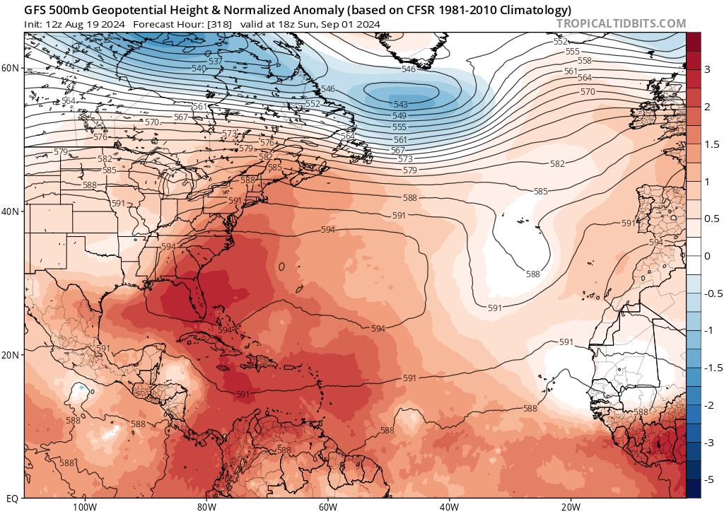
That actually makes sense as Met WXMAN mentioned the Bermuda High not being near as strong as forecasted.
Ubuntwo wrote:ConvergenceZone wrote:mantis83 wrote:looks like recurve city on those maps....
That actually makes sense as Met WXMAN mentioned the Bermuda High not being near as strong as forecasted.
This same met called for a TS or low end cat 1 Beryl into Belize not making it into the Gulf except for ‘maybe briefly into the BOC’, I would never take an individual’s word as gospel. You know as well as the rest of upper-level setups change on a dime this far out, most of those tracks were into the Carib two runs ago.
IcyTundra wrote:Ubuntwo wrote:ConvergenceZone wrote:
That actually makes sense as Met WXMAN mentioned the Bermuda High not being near as strong as forecasted.
This same met called for a TS or low end cat 1 Beryl into Belize not making it into the Gulf except for ‘maybe briefly into the BOC’, I would never take an individual’s word as gospel. You know as well as the rest of upper-level setups change on a dime this far out, most of those tracks were into the Carib two runs ago.
I agree it’s usually best to get opinions from multiple different meteorologists to form your opinion. Wxman is great and one of the many meteorologists I pay attention to.

boca wrote:I was always under the impression that in a possible La Niña or in this case cool neutral that the Bermuda high would be stronger. I guess it’s not the case or just temporary.


boca wrote:I was always under the impression that in a possible La Niña or in this case cool neutral that the Bermuda high would be stronger. I guess it’s not the case or just temporary.


SFLcane wrote:REDHurricane wrote:TomballEd wrote:
Harvey was not yet a hurricane, so two hurricanes and a TS. My bad. But the point remains the tropics aren't about to explode. 2017, to this point, is not 2024.
If we're defining "about to explode" as "going to produce a major hurricane within the next 7 days" then sure, but I can basically guarantee you that 2 (maybe even up to 3 if things progress much slower than expected but I personally doubt that'll happen) weeks from now there will be no more discussion of the season being cancelled or seriously busting relative to expectations. Whether the tropics start really blowing up in the last week of August or the second week of September shouldn't really matter all that much, this season is still extremely likely to meet the hyperactive threshold of 175 ACE or whatever it is, very likely to exceed 200 ACE in my opinion regardless of when "the switch" fully comes into fruition, and has at least like a 25-30% chance of surpassing 2017's ACE of 224.9.
I'll be happy to eat crow if I'm wrong, but either way I still think it's too early to begin doubting the seasonal forecasts put out by CSU, NCSU, NOAA, etc. when we're still nearly two weeks away from September and more than three weeks away from the climatological peak of the season. Will the Atlantic break the all-time ACE record as I predicted in my seasonal forecast submission? Probably not at this point since that would require more consistent activity throughout July/August, but until there's real evidence that the tropics aren't going to ramp up sometime in the next 2ish weeks I see no reason to believe that it won't happen.
We play this game every year until there is 3 hurricanes spinning across the Atl 9/10
wxman57 wrote:It's amazing that we're approaching the peak of the season in 3 weeks and the models are not showing any significant development over the next two weeks. Some here are resorting to finding a possible storm in an odd ensemble member or two. Typically, about half the storms develop prior to Sept. 10th. We might be able to squeeze out another 2-3 named storms by then, making the total 7-8 named storms for the first half of the season (with Sept. 10 as the mid-point). It's going to be hard to reach even 20 named storms unless September turns out to be extremely active with 8-10 named storms and October is equally active. ACE is another story. A single long-tracked major hurricane can generate 50-60 ACE points, so we could be "hyperactive" ACE-wise but a little above normal numbers-wise. I know how quickly the tropics can switch "on", though, but my numbers are now 19/8/5 and that may be a bit too high.
Numbers don't really matter, though. What matters is where the storms track. For now, the Bermuda high is weaker than predicted. We can track waves moving across the MDR, but they're having trouble generating convection due to dry, sinking air. Will this suddenly change over the next 2-3 weeks? The year started off as I suspected, with a long-tracked strong hurricane tracking across the Caribbean. After Beryl, though, things changed. Debby recurved over the NE Caribbean, and other waves just can't generate convection in the MDR.
Those of you in the NE Caribbean, like Luis, are certainly not "out of the woods", as conditions across the MDR will likely become more favorable eventually. Just because waves can't maintain convection in the Caribbean now doesn't mean Gulf Coast residents are safe from any hurricane threat. I've seen many convectionless waves move across the Caribbean suddenly blow up into hurricanes near the Yucatan and move north into the coast. I keep telling my team to track all waves moving across the MDR and Caribbean, as they can blow up in the NW Caribbean and become a "surprise" hurricane in the Gulf.
Let's hope for the best (fewer storms and a reduced risk) but always prepare for the worst.
Users browsing this forum: Google [Bot] and 154 guests


