

2018 EPAC Season
Moderator: S2k Moderators
Forum rules

The posts in this forum are NOT official forecasts and should not be used as such. They are just the opinion of the poster and may or may not be backed by sound meteorological data. They are NOT endorsed by any professional institution or STORM2K. For official information, please refer to products from the National Hurricane Center and National Weather Service.
Re: 2018 EPAC Season
0 likes
The above post and any post by Ntxw is NOT an official forecast and should not be used as such. It is just the opinion of the poster and may or may not be backed by sound meteorological data. It is NOT endorsed by any professional institution including Storm2k. For official information, please refer to NWS products.
Help support Storm2K!
-
cycloneye

- Admin

- Posts: 149505
- Age: 69
- Joined: Thu Oct 10, 2002 10:54 am
- Location: San Juan, Puerto Rico
Re: 2018 EPAC Season
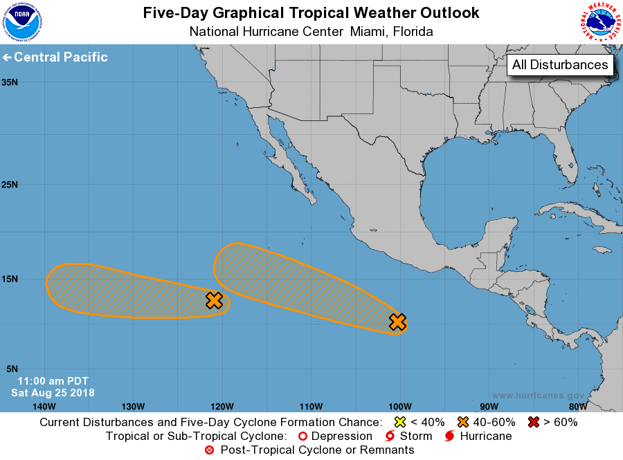
Tropical Weather Outlook
NWS National Hurricane Center Miami FL
500 PM PDT Sat Aug 25 2018
For the eastern North Pacific...east of 140 degrees west longitude:
2. A broad low pressure system located about 500 miles south of
Acapulco, Mexico, continues to produce a large area of disorganized
showers and thunderstorms. Slow development of this system is
expected over the next several days, and a tropical depression could
form by the middle of next week while it moves westward or
west-northwestward at 10 mph.
* Formation chance through 48 hours...low...20 percent.
* Formation chance through 5 days...medium...60 percent.
Forecaster Zelinsky
0 likes
Visit the Caribbean-Central America Weather Thread where you can find at first post web cams,radars
and observations from Caribbean basin members Click Here
and observations from Caribbean basin members Click Here
Re: 2018 EPAC Season
Next names up on the list is Miriam, Norman, and Olivia. Miriam and Norman will likely be taken by the two areas colored. 18z GFS has Olivia and Paul in the longer range but way out there for now.
2 likes
The above post and any post by Ntxw is NOT an official forecast and should not be used as such. It is just the opinion of the poster and may or may not be backed by sound meteorological data. It is NOT endorsed by any professional institution including Storm2k. For official information, please refer to NWS products.
Help support Storm2K!
Help support Storm2K!
-
cycloneye
- Admin
- Posts: 149505
- Age: 69
- Joined: Thu Oct 10, 2002 10:54 am
- Location: San Juan, Puerto Rico
Re: 2018 EPAC Season
Ntxw wrote:Next names up on the list is Miriam, Norman, and Olivia. Miriam and Norman will likely be taken by the two areas colored. 18z GFS has Olivia and Paul in the longer range but way out there for now.
If what GFS has pans out,then the 200 ACE mark will be reached fast.
0 likes
Visit the Caribbean-Central America Weather Thread where you can find at first post web cams,radars
and observations from Caribbean basin members Click Here
and observations from Caribbean basin members Click Here
-
cycloneye
- Admin
- Posts: 149505
- Age: 69
- Joined: Thu Oct 10, 2002 10:54 am
- Location: San Juan, Puerto Rico
Re: 2018 EPAC Season
EPac continues to give birth to Tropical Cyclones as the active period continues to extend after Hector and Lane.We have TD Fifteen-E (Miriam) poised to rack up big ACE numbers and INVEST 90E (Norman) will do the same with even racking up much more than Miriam after it is upgraded.The 200 ACE mark will be reached with Miriam and Norman.Wow,what a hyperactive season the basin has turned out to be in 2018 and after these two are gone,there will be more on the pipe.
3 likes
Visit the Caribbean-Central America Weather Thread where you can find at first post web cams,radars
and observations from Caribbean basin members Click Here
and observations from Caribbean basin members Click Here
Re: 2018 EPAC Season
Might want to start thinking about a top 5 ACE season for the EPAC. The two projected long trackers could each produce 25-30+ easily and that will get it to 200 or more. Anything after is going to to be padding numbers.
When Aletta went beyond forecast to many's surprise as the first storm, was a precursor to the favorable atmosphere. More like what Amanda/Andres did.
When Aletta went beyond forecast to many's surprise as the first storm, was a precursor to the favorable atmosphere. More like what Amanda/Andres did.
3 likes
The above post and any post by Ntxw is NOT an official forecast and should not be used as such. It is just the opinion of the poster and may or may not be backed by sound meteorological data. It is NOT endorsed by any professional institution including Storm2k. For official information, please refer to NWS products.
Help support Storm2K!
Help support Storm2K!
-
1900hurricane

- Category 5

- Posts: 6063
- Age: 34
- Joined: Fri Feb 06, 2015 12:04 pm
- Location: Houston, TX
- Contact:
Re: 2018 EPAC Season
With Lane's downgrade, August ACE is at 108 units even right now. The September 1992 basin ACE record is in trouble at this point with two more imminent tropical storms.
1 likes
Contract Meteorologist. TAMU & MSST. Fiercely authentic, one of a kind. We are all given free will, so choose a life meant to be lived. We are the Masters of our own Stories.
Opinions expressed are mine alone.
Follow me on Twitter at @1900hurricane : Read blogs at https://1900hurricane.wordpress.com/
Opinions expressed are mine alone.
Follow me on Twitter at @1900hurricane : Read blogs at https://1900hurricane.wordpress.com/
-
cycloneye
- Admin
- Posts: 149505
- Age: 69
- Joined: Thu Oct 10, 2002 10:54 am
- Location: San Juan, Puerto Rico
Re: 2018 EPAC Season
Season is at 13/6/4 with newly named Tropical Storm Miriam.
1 likes
Visit the Caribbean-Central America Weather Thread where you can find at first post web cams,radars
and observations from Caribbean basin members Click Here
and observations from Caribbean basin members Click Here
-
Shell Mound
- Category 5
- Posts: 2432
- Age: 33
- Joined: Thu Sep 07, 2017 3:39 pm
- Location: St. Petersburg, FL → Scandinavia
Re: 2018 EPAC Season
1900hurricane wrote:With Lane's downgrade, August ACE is at 108 units even right now. The September 1992 basin ACE record is in trouble at this point with two more imminent tropical storms.
Much of that ACE is likely to be discarded in a credible posthumous analysis (finalised TCR-based best track), given that CPHC grossly overestimated Lane's intensity during its weakening phases. Based on satellite data, the high-bias errors were of substantial magnitude: on the order of 30 knots or more at times. For instance, after Lane's initial Cat-4 peak of 120 knots, it likely weakened to below major-hurricane status, as subsequent satellite imagery suggested only a strong Cat-1 (~80 knots) at most, though CPHC maintained the best track at Cat-3 intensity. Obviously, after attaining its secondary, Cat-5 peak of 140 knots, Lane weakened much more rapidly than officially depicted, as it neared the Hawaiian Islands. CPHC was maintaining the winds at 90 knots when satellite and land data showed only a low-end TS by then. Even slight downward adjustments to Irma (2017) made a rather noticeable difference in ACE totals, so any big adjustments to Lane's intensity would shave quite a bit of the seasonal ACE.
Last edited by Shell Mound on Sun Aug 26, 2018 11:58 am, edited 1 time in total.
0 likes
CVW / MiamiensisWx / Shell Mound
The posts in this forum are NOT official forecasts and should not be used as such. They are just the opinion of the poster and may or may not be backed by sound meteorological data. They are NOT endorsed by any professional institution or STORM2K. For official information, please refer to products from the NHC and NWS.
Re: 2018 EPAC Season
Shell Mound wrote:1900hurricane wrote:With Lane's downgrade,August ACE is at 108 units even right now. The September 1992 basin ACE record is in trouble at this point with two more imminent tropical storms.
Much of that ACE is likely to be discarded in a credible posthumous analysis (finalised TCR-based best track), given that CPHC grossly overestimated Lane's intensity during its weakening phases. Based on satellite data, the high-bias errors were of substantial magnitude: on the order of 30 knots or more at times. For instance, after Lane's initial Cat-4 peak of 120 knots, it likely weakened to below major-hurricane status, as subsequent satellite imagery suggested only a strong Cat-1 (~80 knots) at most, though CPHC maintained the best track at Cat-3 intensity. Obviously, after attaining its secondary, Cat-5 peak of 140 knots, Lane weakened much more rapidly than officially depicted, as it neared the Hawaiian Islands. CPHC was maintaining the winds at 90 knots when satellite and land data showed only a low-end TS by then. Even slight downward adjustments to Irma (2017) made a rather noticeable difference in ACE totals, so any big adjustments to Lane's intensity would shave quite a bit of the seasonal ACE.
Also some low estimates prior to Cat 5 status as well. Hector may also need to be re-looked at so in my opinion it may not be substantial markups or down in the end net wise. Miriam alone the next few days will make up for it regardless. You're looking at a few points here and there which is within margins, tenths of a point a day is not going to swing it wildy.
7 likes
The above post and any post by Ntxw is NOT an official forecast and should not be used as such. It is just the opinion of the poster and may or may not be backed by sound meteorological data. It is NOT endorsed by any professional institution including Storm2k. For official information, please refer to NWS products.
Help support Storm2K!
Help support Storm2K!
-
cycloneye
- Admin
- Posts: 149505
- Age: 69
- Joined: Thu Oct 10, 2002 10:54 am
- Location: San Juan, Puerto Rico
Re: 2018 EPAC Season
There will be plenty of fuel out there for TS Miriam,future Norman and the ones that will form on long range if GFS/Euro are right.

0 likes
Visit the Caribbean-Central America Weather Thread where you can find at first post web cams,radars
and observations from Caribbean basin members Click Here
and observations from Caribbean basin members Click Here
-
Astromanía
- Category 2

- Posts: 796
- Age: 27
- Joined: Sat Aug 25, 2018 10:34 pm
- Location: Monterrey, N.L, México
Re: 2018 EPAC Season
Is it possible have an hyperactive season in both EPAC and NATL in one year?
0 likes
Re: 2018 EPAC Season
Astromanía wrote:Is it possible have an hyperactive season in both EPAC and NATL in one year?
It's not very likely. You can have similar ACE finishes when both are near normal. But to have one be Hyperactive, the other is not likely to be hyperactive due to the nature of favored areas of rising motion and shifts of the walker circulation etc. See-saw relationship.
1 likes
The above post and any post by Ntxw is NOT an official forecast and should not be used as such. It is just the opinion of the poster and may or may not be backed by sound meteorological data. It is NOT endorsed by any professional institution including Storm2k. For official information, please refer to NWS products.
Help support Storm2K!
Help support Storm2K!
-
Astromanía
- Category 2
- Posts: 796
- Age: 27
- Joined: Sat Aug 25, 2018 10:34 pm
- Location: Monterrey, N.L, México
Re: 2018 EPAC Season
Ntxw wrote:Astromanía wrote:Is it possible have an hyperactive season in both EPAC and NATL in one year?
It's not very likely. You can have similar ACE finishes when both are near normal. But to have one be Hyperactive, the other is not likely to be hyperactive due to the nature of favored areas of rising motion and shifts of the walker circulation etc. See-saw relationship.
So we might expect a near average season for NATL this year at best, right?
1 likes
Re: 2018 EPAC Season
Astromanía wrote:Ntxw wrote:Astromanía wrote:Is it possible have an hyperactive season in both EPAC and NATL in one year?
It's not very likely. You can have similar ACE finishes when both are near normal. But to have one be Hyperactive, the other is not likely to be hyperactive due to the nature of favored areas of rising motion and shifts of the walker circulation etc. See-saw relationship.
So we might expect a near average season for NATL this year at best, right?
Probably so if you are using the EPAC as a measuring stick. The hyperactive Atlantic seasons (1995, 1996, 1998, 1999, 2003, 2004, 2005, 2010, 2017) were all near normal or below normal EPAC seasons (using 1971 as starting point since EPAC data is limited prior). For the EPAC years that went over 200 ACE (1978, 1983, 1990, 1992, 1993, 2015) were near normal to below normal Atlantic seasons. Sample size being small as a caveat. 2016 is probably the closest year that both seasons were well above normal ACE almost to hyperactive threshold.
4 likes
The above post and any post by Ntxw is NOT an official forecast and should not be used as such. It is just the opinion of the poster and may or may not be backed by sound meteorological data. It is NOT endorsed by any professional institution including Storm2k. For official information, please refer to NWS products.
Help support Storm2K!
Help support Storm2K!
-
xtyphooncyclonex

- Category 5
- Posts: 3891
- Age: 24
- Joined: Sat Dec 08, 2012 9:07 am
- Location: Cebu City
- Contact:
Re: 2018 EPAC Season
Astromanía wrote:Is it possible have an hyperactive season in both EPAC and NATL in one year?
I doubt it.
But in 2016, the ATL was (close to) hyperactive since it was definitely above-average and the EPAC was hyperactive, the last season in the 2014-16 string.
0 likes
REMINDER: My opinions that I, or any other NON Pro-Met in this forum, are unofficial. Please do not take my opinions as an official forecast and warning. I am NOT a meteorologist. Following my forecasts blindly may lead to false alarm, danger and risk if official forecasts from agencies are ignored.
-
xtyphooncyclonex
- Category 5
- Posts: 3891
- Age: 24
- Joined: Sat Dec 08, 2012 9:07 am
- Location: Cebu City
- Contact:
Re: 2018 EPAC Season
xtyphooncyclonex wrote:Going for a rather active season, possibly a repeat of 2006.... I can't give my numners yet, but I like the names in this list, especially Lane, Olivia, my name (Sergio)and Tara!!
Forgot Hector. Add Miriam and Norman to these. I was not really impressed with short-lived Aletta and Bud.
I'm going with 21/12/8 (give or take two) with an ACE index of slightly over 200. Yes, I expect six of the next seven to eight storms to become hurricanes.
3 likes
REMINDER: My opinions that I, or any other NON Pro-Met in this forum, are unofficial. Please do not take my opinions as an official forecast and warning. I am NOT a meteorologist. Following my forecasts blindly may lead to false alarm, danger and risk if official forecasts from agencies are ignored.
-
cycloneye
- Admin
- Posts: 149505
- Age: 69
- Joined: Thu Oct 10, 2002 10:54 am
- Location: San Juan, Puerto Rico
Re: 2018 EPAC Season
Here comes another one.

Another area of low pressure is forecast to form well south or
southwest the coast of southwestern Mexico later this week.
Conditions are expected to be conducive for gradual development of
this system this weekend.
* Formation chance through 48 hours...low...near 0 percent.
* Formation chance through 5 days...low...20 percent.
southwest the coast of southwestern Mexico later this week.
Conditions are expected to be conducive for gradual development of
this system this weekend.
* Formation chance through 48 hours...low...near 0 percent.
* Formation chance through 5 days...low...20 percent.
0 likes
Visit the Caribbean-Central America Weather Thread where you can find at first post web cams,radars
and observations from Caribbean basin members Click Here
and observations from Caribbean basin members Click Here
-
Yellow Evan

- Professional-Met

- Posts: 16240
- Age: 27
- Joined: Fri Jul 15, 2011 12:48 pm
- Location: Henderson, Nevada/Honolulu, HI
- Contact:
Who is online
Users browsing this forum: Ntxw and 309 guests