Low pressure developing over the western Caribbean Sea (Is Invest 97L)
Moderator: S2k Moderators
Forum rules

The posts in this forum are NOT official forecasts and should not be used as such. They are just the opinion of the poster and may or may not be backed by sound meteorological data. They are NOT endorsed by any professional institution or STORM2K. For official information, please refer to products from the National Hurricane Center and National Weather Service.
-
redingtonbeach
- Tropical Depression

- Posts: 65
- Joined: Mon Sep 04, 2017 12:05 am
Re: Area of low pressure to develop over the western Caribbean sea (0/70)
Should have already been tagged. Agree. Having a senior at UF and watching the public schools making dangerous last minute decisions this year already worries me a bit with this storm. With Gainesville all but certain to see some wrath from this storm, and all the brand new freshmen who just hit campus and 70% of the students living off campus mostly in flood zone relic shacks, somebody needs to get their act together in a hurry. Last time the university cancelled classes students stayed put because classes were cancelled too late and many didn’t even know they didn’t have to go in for exams or classes. Very dangerous setup, especially with the increasing intensity modeling.
2 likes
-
SFLcane

- S2K Supporter

- Posts: 10281
- Age: 48
- Joined: Sat Jun 05, 2010 1:44 pm
- Location: Lake Worth Florida
Re: Area of low pressure to develop over the western Caribbean sea (0/70)
Easy trend continues with still 5-6 days before this even becomes a threat to anyone.
1 likes
-
redingtonbeach
- Tropical Depression
- Posts: 65
- Joined: Mon Sep 04, 2017 12:05 am
Re: Area of low pressure to develop over the western Caribbean sea (0/70)
sorry for dupe posts. There used to be an "X" we could delete our posts - I don't see that now on my dupes
1 likes

Re: Area of low pressure to develop over the western Caribbean sea (0/70)
redingtonbeach wrote:sorry for dupe posts. There used to be an "X" we could delete our posts - I don't see that now on my dupes
I was going to spare you the “you can say that again” razz but you are correct. X is gone from the site. Remind me again (and again and again) not to drink coffee at a restaurant at 11:30pm again.
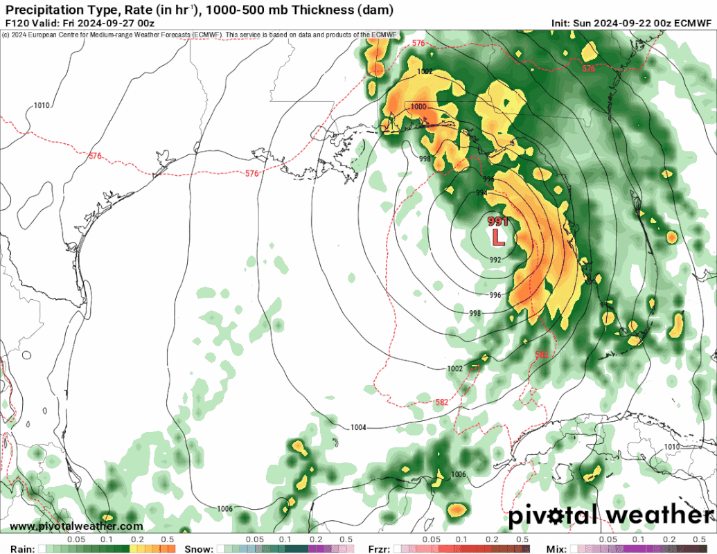
EC hits Apalachicola at 989 Friday morning at 1:00am. This is a believable run in my opinion though I wouldn’t be surprised to see it a hair farther west toward Bay County. Upper low that grabs it is at MO/AR border and pulls it up from the perimeter.
https://www.pivotalweather.com/model.ph ... &dpdt=&mc=
2 likes
-
AtlanticWind

- S2K Supporter
- Posts: 1898
- Age: 67
- Joined: Sun Aug 08, 2004 9:57 pm
- Location: Plantation,Fla
Re: Area of low pressure to develop over the western Caribbean sea (0/70)
redingtonbeach wrote:CrazyC83 wrote:Despite being 0% for the next 2 days, I'd tag it as 97L ASAP, since we need the model runs as the thinking is that this could be a quick-hitter.
Should have already been tagged. Agree. Having a senior at Uf and watching the public schools making dangerous last minute decisions this year already worries me a bit with this storm. With Gainesville all but certain to see some wrath from this storm, and all the brand new freshmen who just hit campus and 70% of the students living off campus mostly in flood zone relic shacks, somebody needs to get their act together in a hurry. Last time the university cancelled classes students stayed put because classes were cancelled too late and many didn’t even know they didn’t have to go in for exams or classes. Very dangerous setup.
Hurricane Model runs won’t help until we get at least an idea where the center is forming
0 likes
-
ThunderForce

- Tropical Storm

- Posts: 208
- Age: 26
- Joined: Tue Sep 27, 2022 6:20 pm
- Location: Calhoun County, Florida
Re: Area of low pressure to develop over the western Caribbean sea (0/70)
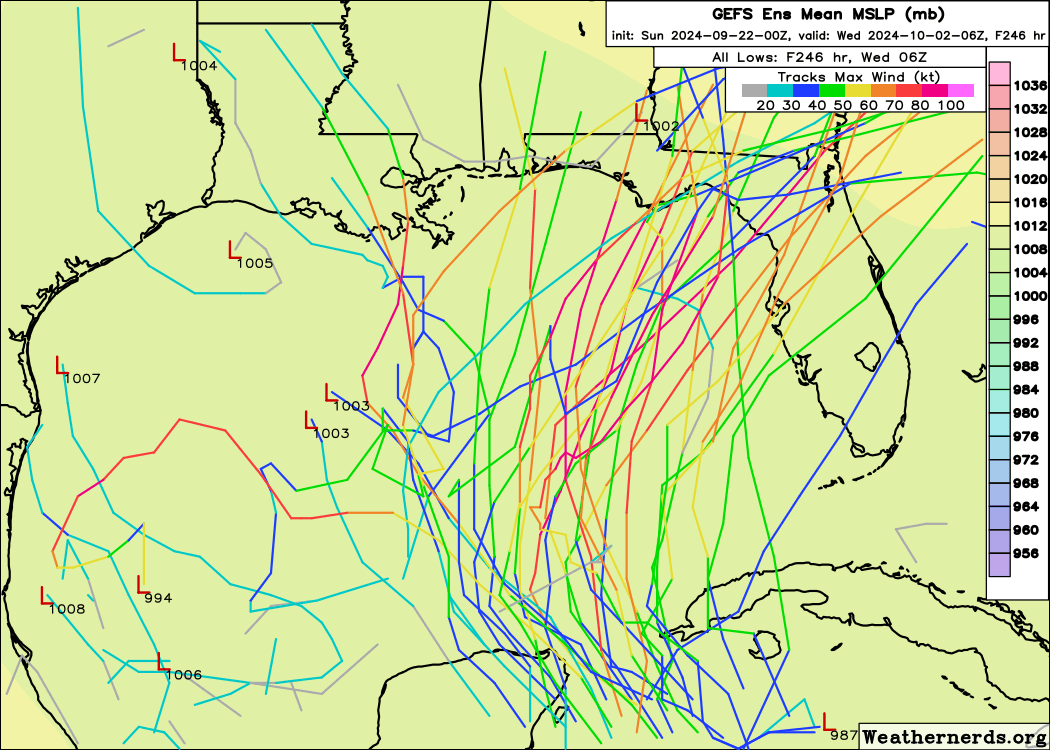
Weathernerds 00z GEFS ensembles:
0 likes
Please refer to the NWS, NHC, SPC or a professional meteorologist for information and decision making during storms.

Re: Area of low pressure to develop over the western Caribbean sea (0/70)
AtlanticWind wrote:redingtonbeach wrote:CrazyC83 wrote:Despite being 0% for the next 2 days, I'd tag it as 97L ASAP, since we need the model runs as the thinking is that this could be a quick-hitter.
Should have already been tagged. Agree. Having a senior at Uf and watching the public schools making dangerous last minute decisions this year already worries me a bit with this storm. With Gainesville all but certain to see some wrath from this storm, and all the brand new freshmen who just hit campus and 70% of the students living off campus mostly in flood zone relic shacks, somebody needs to get their act together in a hurry. Last time the university cancelled classes students stayed put because classes were cancelled too late and many didn’t even know they didn’t have to go in for exams or classes. Very dangerous setup.
Hurricane Model runs won’t help until we get at least an idea where the center is forming
Recon adds valuable data to feed to the models and they won't run recon missions until an invest is labeled
0 likes
-
Stormlover70
- Tropical Storm
- Posts: 194
- Age: 56
- Joined: Fri Jun 21, 2024 5:31 am
- Location: New port richey
Re: Area of low pressure to develop over the western Caribbean sea (0/70)
getting concerned here in Pasco County.SFLcane wrote:Easy trend continues with still 5-6 days before this even becomes a threat to anyone.
https://i.postimg.cc/BQLMZQfH/IMG-9460.gif
0 likes

Re: Area of low pressure to develop over the western Caribbean sea (0/70)
Massive 700mb gyre centered over Honduras with a strong 500mb vort centered just south of Grand Cayman.
Just as GFS forecasted a few days ago.
Looks like GFS is on par.
Big positive-tilted 250mb trough overhead currently creating shear induced convection.
Any big hot-towers should drive the mid-level vorts to the surface in the next couple days.
GFS has the LL vort entering the GoM thru the Yucatan Channel.
Will be ahead of the tail of a Rossby Wave then.
At that point need to see if an anti-cyclone develops overhead or if gets caught up in the RW's UL flow and gets sheared.
5 likes
-
eastcoastFL

- Category 5

- Posts: 3996
- Age: 44
- Joined: Thu Apr 12, 2007 12:29 pm
- Location: Palm City, FL
Re: Area of low pressure to develop over the western Caribbean sea (0/70)
EC-AIFS brings it into the big bend area in the 970's on Thursday. So that's a landfilling cat 2 hurricane just 5 days from now. Yet 5 days out we don't even have a system to investigate and we're unable to issue proper public warnings. This could get ugly fast and have very little lead time.
I think we're pretty safe on my side of the state but I'm going to get some fuel and water today just to be safe.
I think we're pretty safe on my side of the state but I'm going to get some fuel and water today just to be safe.
1 likes
Personal Forecast Disclaimer:
The posts in this forum are NOT official forecast and should not be used as such. They are just the opinion of the poster and may or may not be backed by sound meteorological data. They are NOT endorsed by any professional institution or storm2k.org. For official information, please refer to the NHC and NWS products.
The posts in this forum are NOT official forecast and should not be used as such. They are just the opinion of the poster and may or may not be backed by sound meteorological data. They are NOT endorsed by any professional institution or storm2k.org. For official information, please refer to the NHC and NWS products.

Re: Area of low pressure to develop over the western Caribbean sea (0/70)
Stormlover70 wrote:getting concerned here in Pasco County.SFLcane wrote:Easy trend continues with still 5-6 days before this even becomes a threat to anyone.
https://i.postimg.cc/BQLMZQfH/IMG-9460.gif
And folks between Pensacola and Biloxi should equally be concerned if they follow the EURO members. So now, which model is going to be more accurate?
0 likes
-
eastcoastFL
- Category 5
- Posts: 3996
- Age: 44
- Joined: Thu Apr 12, 2007 12:29 pm
- Location: Palm City, FL
Re: Area of low pressure to develop over the western Caribbean sea (0/70)
GCANE wrote:Massive 700mb gyre centered over Honduras with a strong 500mb vort centered just south of Grand Cayman.
Just as GFS forecasted a few days ago.
Looks like GFS is on par.
Big positive-tilted 250mb trough overhead currently creating shear induced convection.
Any big hot-towers should drive the mid-level vorts to the surface in the next couple days.
GFS has the LL vort entering the GoM thru the Yucatan Channel.
Will be ahead of the tail of a Rossby Wave then.
At that point need to see if an anti-cyclone develops overhead or if gets caught up in the RW's UL flow and gets sheared.
Hey G, is that slop moving around the W. Carib the ingredients to our future storm? Is that expected to move into the AOI published by the NHC?
1 likes
Personal Forecast Disclaimer:
The posts in this forum are NOT official forecast and should not be used as such. They are just the opinion of the poster and may or may not be backed by sound meteorological data. They are NOT endorsed by any professional institution or storm2k.org. For official information, please refer to the NHC and NWS products.
The posts in this forum are NOT official forecast and should not be used as such. They are just the opinion of the poster and may or may not be backed by sound meteorological data. They are NOT endorsed by any professional institution or storm2k.org. For official information, please refer to the NHC and NWS products.
Re: Area of low pressure to develop over the western Caribbean sea (0/70)
Looks like everything is getting sheared at tbe moment down there in the Caribbean. Going to be difficult to get any cyclogenisis for a number of days… 
ATM I doubt this turns out to be nothing more than a Francine or even less than Francine.
ATM I doubt this turns out to be nothing more than a Francine or even less than Francine.
1 likes
-
eastcoastFL
- Category 5
- Posts: 3996
- Age: 44
- Joined: Thu Apr 12, 2007 12:29 pm
- Location: Palm City, FL
Re: Area of low pressure to develop over the western Caribbean sea (0/70)
3090 wrote:Looks like everything is getting sheared at tbe moment down there in the Caribbean. Going to be difficult to get any cyclogenisis for a number of days…
ATM I doubt this turns out to be nothing more than a Francine or even less than Francine.
I don't think it's expected to develop there. Looking at the red area marked off by the NHC it seems like they expect it develop further north and west.
0 likes
Personal Forecast Disclaimer:
The posts in this forum are NOT official forecast and should not be used as such. They are just the opinion of the poster and may or may not be backed by sound meteorological data. They are NOT endorsed by any professional institution or storm2k.org. For official information, please refer to the NHC and NWS products.
The posts in this forum are NOT official forecast and should not be used as such. They are just the opinion of the poster and may or may not be backed by sound meteorological data. They are NOT endorsed by any professional institution or storm2k.org. For official information, please refer to the NHC and NWS products.
Re: Area of low pressure to develop over the western Caribbean sea (0/70)
eastcoastFL wrote:3090 wrote:Looks like everything is getting sheared at tbe moment down there in the Caribbean. Going to be difficult to get any cyclogenisis for a number of days…
ATM I doubt this turns out to be nothing more than a Francine or even less than Francine.
I don't think it's expected to develop there. Looking at the red area marked off by the NHC it seems like they expect it develop further north and west.
What red “X”, of the NHC? There is none ATM. Nothing (no low pressure) is expected to form any where in the next 48 hours.
0 likes
-
Stormlover70
- Tropical Storm
- Posts: 194
- Age: 56
- Joined: Fri Jun 21, 2024 5:31 am
- Location: New port richey
Re: Area of low pressure to develop over the western Caribbean sea (0/70)
gfs has been consistently shifting east.3090 wrote:Stormlover70 wrote:getting concerned here in Pasco County.SFLcane wrote:Easy trend continues with still 5-6 days before this even becomes a threat to anyone.
https://i.postimg.cc/BQLMZQfH/IMG-9460.gif
And folks between Pensacola and Biloxi should equally be concerned if they follow the EURO members. So now, which model is going to be more accurate?
1 likes
Re: Area of low pressure to develop over the western Caribbean sea (0/70)
Steve wrote:MetroMike wrote:Blown Away wrote:[url]https://i.postimg.cc/k5KDyWF9/icon-mslp-pcpn-watl-fh48-180.gif [/url]
00z ICON… Large shift E from 12z near LA now in line with GFS near FL Big Bend…
Not an unusual track for this time of year given current set-up
No but that pressure is way low from what we’d typically see in that area. There might have been a couple systems, if that, in the last 200 years that got into the 940’s and hit the big bend. Idalia got to 950 (I think?) last year and was historic. This would be in that range back to back years which would be unprecedented. Not saying it can’t happen but it’s suspect at 949.
Hey Bud. I Hope you are well. I think that's due to just blind luck. Charley, Irma and Ian were all at one point were due to hit us here in the Tampa Bay and just a slight shift right and it went South. Just a small shift left they hit further North. The bullseye has certainly been on the big bend last few years and we're sitting here in the Tampa Bay area between the goal posts.
2 likes
-
eastcoastFL
- Category 5
- Posts: 3996
- Age: 44
- Joined: Thu Apr 12, 2007 12:29 pm
- Location: Palm City, FL
Re: Area of low pressure to develop over the western Caribbean sea (0/70)
3090 wrote:eastcoastFL wrote:3090 wrote:Looks like everything is getting sheared at tbe moment down there in the Caribbean. Going to be difficult to get any cyclogenisis for a number of days…
ATM I doubt this turns out to be nothing more than a Francine or even less than Francine.
I don't think it's expected to develop there. Looking at the red area marked off by the NHC it seems like they expect it develop further north and west.
What red “X”, of the NHC? There is none ATM. Nothing (no low pressure) is expected to form any where in the next 48 hours.
You need to look at the 7 day map
https://www.nhc.noaa.gov/gtwo.php?basin=atl
c&fdays=7
1 likes
Personal Forecast Disclaimer:
The posts in this forum are NOT official forecast and should not be used as such. They are just the opinion of the poster and may or may not be backed by sound meteorological data. They are NOT endorsed by any professional institution or storm2k.org. For official information, please refer to the NHC and NWS products.
The posts in this forum are NOT official forecast and should not be used as such. They are just the opinion of the poster and may or may not be backed by sound meteorological data. They are NOT endorsed by any professional institution or storm2k.org. For official information, please refer to the NHC and NWS products.

Re: Area of low pressure to develop over the western Caribbean sea (0/70)
I continue to remain skeptical of development until actually seeing development. Having said that, seeing all global models roughly share similar forecasts for genesis and intensity does give me pause. For now however, I will remain firmly perched upon the wild steel fence that I ride (wait, isn't that the theme song from Deadliest Catch?  )
)
1 likes
Andy D
(For official information, please refer to the NHC and NWS products.)
(For official information, please refer to the NHC and NWS products.)
Who is online
Users browsing this forum: No registered users and 168 guests