Low pressure developing over the western Caribbean Sea (Is Invest 97L)
Moderator: S2k Moderators
Forum rules

The posts in this forum are NOT official forecasts and should not be used as such. They are just the opinion of the poster and may or may not be backed by sound meteorological data. They are NOT endorsed by any professional institution or STORM2K. For official information, please refer to products from the National Hurricane Center and National Weather Service.
-
otowntiger
- Category 5

- Posts: 1932
- Joined: Tue Aug 31, 2004 7:06 pm
Re: Area of low pressure to develop over the western Caribbean sea (0/70)
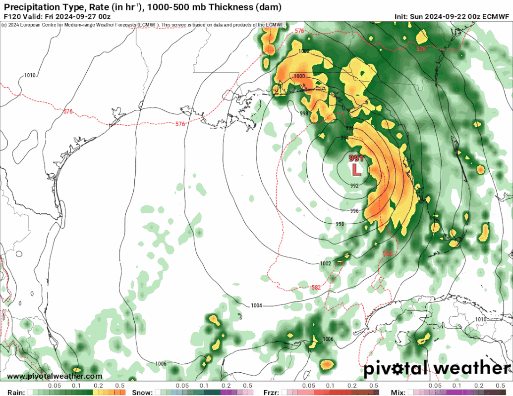
Gfs not good for FL - back to back majors- but of course a lot can change- especially for the second one in long range. Btw- what’s up with The Euro run on Tropical tidbits? It keeps show the halfway run from midday yesterday. Doesn’t seem to updating can’t tell what it’s showing now.
0 likes
-
jlauderdal
- S2K Supporter

- Posts: 7240
- Joined: Wed May 19, 2004 5:46 am
- Location: NE Fort Lauderdale
- Contact:
Re: Area of low pressure to develop over the western Caribbean sea (0/70)
3090 wrote:Stormlover70 wrote:getting concerned here in Pasco County.SFLcane wrote:Easy trend continues with still 5-6 days before this even becomes a threat to anyone.
https://i.postimg.cc/BQLMZQfH/IMG-9460.gif
And folks between Pensacola and Biloxi should equally be concerned if they follow the EURO members. So now, which model is going to be more accurate?
We can't discount the Euro completely, but what we do know is that it had a westerly solution and now has moved significantly to the east, playing catch up with the other guidance. Watch the trends and it has been significantly east the last 24 hours. Apalachicola to Sarasota, I moved my goal posts in on the east and west sides.
0 likes
-
Stormlover70
- Tropical Storm

- Posts: 194
- Age: 56
- Joined: Fri Jun 21, 2024 5:31 am
- Location: New port richey
Re: Area of low pressure to develop over the western Caribbean sea (0/70)
link to long range gfs?otowntiger wrote:Gfs not good for FL - back to back majors- but of course a lot can change- especially for the second one in long range. Btw- what’s up with The Euro run on Tropical tidbits? It keeps show the halfway run from midday yesterday. Doesn’t seem to updating can’t tell what it’s showing now.
0 likes
-
otowntiger
- Category 5
- Posts: 1932
- Joined: Tue Aug 31, 2004 7:06 pm
Re: Area of low pressure to develop over the western Caribbean sea (0/70)
Stormlover70 wrote:link to long range gfs?otowntiger wrote:Gfs not good for FL - back to back majors- but of course a lot can change- especially for the second one in long range. Btw- what’s up with The Euro run on Tropical tidbits? It keeps show the halfway run from midday yesterday. Doesn’t seem to updating can’t tell what it’s showing now.
https://www.tropicaltidbits.com/analysi ... 92118&fh=6
0 likes
-
ThunderForce

- Tropical Storm
- Posts: 208
- Age: 26
- Joined: Tue Sep 27, 2022 6:20 pm
- Location: Calhoun County, Florida
Re: Area of low pressure to develop over the western Caribbean sea (0/70)
Looks like the GFS caved to the Euro and CMC. The storm is quite a bit west on the 06z run, with the trough's progression being closer to those two models than the previous GFS run.
EDIT: Makes landfall as a 961 MB hurricane in Walton County, FL.
EDIT: Makes landfall as a 961 MB hurricane in Walton County, FL.
Last edited by ThunderForce on Sun Sep 22, 2024 5:11 am, edited 1 time in total.
1 likes
Please refer to the NWS, NHC, SPC or a professional meteorologist for information and decision making during storms.
-
Stormlover70
- Tropical Storm
- Posts: 194
- Age: 56
- Joined: Fri Jun 21, 2024 5:31 am
- Location: New port richey
Re: Area of low pressure to develop over the western Caribbean sea (0/70)
wow!otowntiger wrote:Stormlover70 wrote:link to long range gfs?otowntiger wrote:Gfs not good for FL - back to back majors- but of course a lot can change- especially for the second one in long range. Btw- what’s up with The Euro run on Tropical tidbits? It keeps show the halfway run from midday yesterday. Doesn’t seem to updating can’t tell what it’s showing now.
https://www.tropicaltidbits.com/analysi ... 92118&fh=6
0 likes
-
otowntiger
- Category 5
- Posts: 1932
- Joined: Tue Aug 31, 2004 7:06 pm
Re: Area of low pressure to develop over the western Caribbean sea (0/70)
Latest GFS windshield wipering way west- between Pensacola and Panama City, lol! So much for easterly ‘trends’ lol!  . But I do understand these wild swings in location and intensity in model runs to be like this until there is a consolidated center to actually track. The next run may show central Texas, and then the next could show South FL for all I know, which isn’t much less than the models at this time.
Last edited by otowntiger on Sun Sep 22, 2024 5:18 am, edited 1 time in total.
0 likes
-
ThunderForce
- Tropical Storm
- Posts: 208
- Age: 26
- Joined: Tue Sep 27, 2022 6:20 pm
- Location: Calhoun County, Florida
Re: Area of low pressure to develop over the western Caribbean sea (0/70)
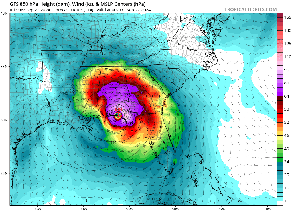
What's bad is that the GFS has this making landfall by sometime during the evening/night on the 26th on forecast hour 114. It seems to start organizing into a TD/TS on the 24th.
06z GFS has formation into a TD/TS only 2 days away, and landfall as a hurricane only 4 days away. Assuming NHC waits until it organizes into a TD to designate it in some capacity, and it goes like the current GFS is showing, people will have very little time and notice to prepare/evacuate.
06z GFS has formation into a TD/TS only 2 days away, and landfall as a hurricane only 4 days away. Assuming NHC waits until it organizes into a TD to designate it in some capacity, and it goes like the current GFS is showing, people will have very little time and notice to prepare/evacuate.
Last edited by ThunderForce on Sun Sep 22, 2024 5:19 am, edited 3 times in total.
0 likes
Please refer to the NWS, NHC, SPC or a professional meteorologist for information and decision making during storms.
-
jlauderdal
- S2K Supporter
- Posts: 7240
- Joined: Wed May 19, 2004 5:46 am
- Location: NE Fort Lauderdale
- Contact:
Re: Area of low pressure to develop over the western Caribbean sea (0/70)
otowntiger wrote:Latest GFS windshield wipering way west- between Pensacola and Panama City, lol! So much for easterly ‘trends’ lol!
Lets see if this is a trend or just a one off.
1 likes
-
Stratton23
- Category 5
- Posts: 3575
- Joined: Fri Jul 21, 2023 10:59 pm
- Location: Katy, Tx
Re: Area of low pressure to develop over the western Caribbean sea (0/70)
GFS shifted west because it now cuts off the trough instead of just progressing eastward, it cuts off and dives to the SW, allowing a little more of a ridge to build off the se US ,
1 likes
-
Ivanhater

- Storm2k Moderator

- Posts: 11222
- Age: 39
- Joined: Fri Jul 01, 2005 8:25 am
- Location: Pensacola
Re: Area of low pressure to develop over the western Caribbean sea (0/70)
Well shoot. Euro, GFS and CMC liking northwest Florida currently. Hopefully today they will change somewhere else 
1 likes
Michael

Re: Area of low pressure to develop over the western Caribbean sea (0/70)
Stratton23 wrote:GFS shifted west because it now cuts off the trough instead of just progressing eastward, it cuts off and dives to the SW, allowing a little more of a ridge to build off the se US ,
Stronger ridging this run but other than taking the time to look, I don't think this can qualify as a trend till all the models show the same evolution. LLC position is still unknown, the surface pressure yoyo'd again south of Jamaica but no circulation yet, just the shear induced convection as the high builds over the area.
2 likes
-
Weathertracker96
- Tropical Storm
- Posts: 150
- Joined: Mon Oct 16, 2023 3:41 pm
Re: Area of low pressure to develop over the western Caribbean sea (0/70)
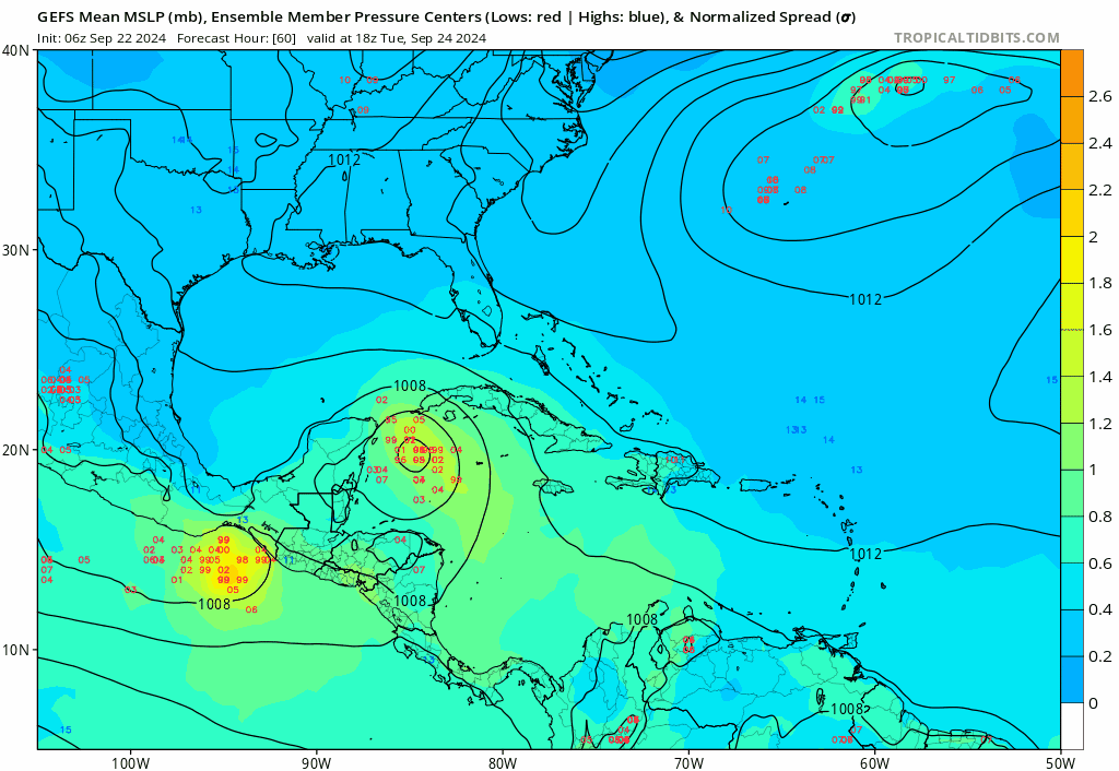
The 06 GEFS ensembles looks more east over the peninsula of FL. Definitely need to see where the center forms and watch the trough progression
Last edited by Weathertracker96 on Sun Sep 22, 2024 5:46 am, edited 2 times in total.
0 likes
Re: Area of low pressure to develop over the western Caribbean sea (0/70)
Ivanhater wrote:Well shoot. Euro, GFS and CMC liking northwest Florida currently. Hopefully today they will change somewhere else
yeah not looking good for your area at this time, things could change but models seem to be honing in.......
0 likes
Re: Area of low pressure to develop over the western Caribbean sea (0/70)
Lets hope for a dud.....hopefully tha forces of nature will be kind....
2 likes
-
gatorcane

- S2K Supporter
- Posts: 23708
- Age: 48
- Joined: Sun Mar 13, 2005 3:54 pm
- Location: Boca Raton, FL
Re: Area of low pressure to develop over the western Caribbean sea (0/70)
Weathertracker96 wrote:The 06 GEFS ensembles looks more east over the peninsula of FL. Definitely need to see where the center forms and watch the trough progression
Saved looped, lots turning this NE into the FL peninsula:
1 likes
-
cycloneye

- Admin

- Posts: 149720
- Age: 69
- Joined: Thu Oct 10, 2002 10:54 am
- Location: San Juan, Puerto Rico
Re: Area of low pressure to develop over the western Caribbean sea (0/70)
This area just east of Nicaragua is the one to watch for consolidation and to form a low pressure.

You nailed it. This thread has the new record for more posts for a pre invest area surpassing the 1075 number of posts from the pre Francine thread.
Category5Kaiju wrote:Oh boy, here we go...
I have a feeling this will be quite the thread.
You nailed it. This thread has the new record for more posts for a pre invest area surpassing the 1075 number of posts from the pre Francine thread.
7 likes
Visit the Caribbean-Central America Weather Thread where you can find at first post web cams,radars
and observations from Caribbean basin members Click Here
and observations from Caribbean basin members Click Here
-
gatorcane
- S2K Supporter
- Posts: 23708
- Age: 48
- Joined: Sun Mar 13, 2005 3:54 pm
- Location: Boca Raton, FL
Re: Area of low pressure to develop over the western Caribbean sea (0/70)
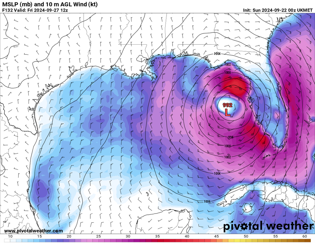
Huge shift east by the UKMET, eventually landfalls near Cedar Key:
1 likes
Re: Area of low pressure to develop over the western Caribbean sea (0/70)
cycloneye wrote:This area just east of Nicaragua is the one to watch for consolidation and to form a low pressure.
https://i.imgur.com/jgkHuP8.gifCategory5Kaiju wrote:Oh boy, here we go...
I have a feeling this will be quite the thread.
You nailed it. This thread has the new record for more posts for a pre invest area surpassing the 1075 number of posts from the pre Francine thread.
I was about to post the same area. Surprised no invest yet.
1 likes
-
eastcoastFL

- Category 5
- Posts: 3996
- Age: 44
- Joined: Thu Apr 12, 2007 12:29 pm
- Location: Palm City, FL
Re: Area of low pressure to develop over the western Caribbean sea (0/70)
ThunderForce wrote:What's bad is that the GFS has this making landfall by sometime during the evening/night on the 26th on forecast hour 114. It seems to start organizing into a TD/TS on the 24th.
06z GFS has formation into a TD/TS only 2 days away, and landfall as a hurricane only 4 days away. Assuming NHC waits until it organizes into a TD to designate it in some capacity, and it goes like the current GFS is showing, people will have very little time and notice to prepare/evacuate.
Lead time is going to be a major issue here if this pans out. I imagine they'll slap a PTC on the board as soon as they possibly can. But the first advisory is probably going to already be in the 3 day forecast cone for landfall.
1 likes
Personal Forecast Disclaimer:
The posts in this forum are NOT official forecast and should not be used as such. They are just the opinion of the poster and may or may not be backed by sound meteorological data. They are NOT endorsed by any professional institution or storm2k.org. For official information, please refer to the NHC and NWS products.
The posts in this forum are NOT official forecast and should not be used as such. They are just the opinion of the poster and may or may not be backed by sound meteorological data. They are NOT endorsed by any professional institution or storm2k.org. For official information, please refer to the NHC and NWS products.
Who is online
Users browsing this forum: Kingarabian and 143 guests